Thursday, December 31, 2009

MWN thanks YOU for a great 2009!

I want to take this opportunity to thank all of my blog readers, website visitors, fans, and followers on my social media sites for their fabulous support throughout 2009. It has been a great year for MemphisWeather.net and that can only be attributed to your patronage. I have said before that MWN only exists because of all of you - without you there would be no need to update the web, blog, or social media sites. As it turns out, you are visiting in droves and for that I am grateful!

In 2009, MemphisWeather.net jumped into the social media realm - once again I was blown away by the response! The Facebook site opened up on Feb. 28 - in the midst of the biggest snow storm of the year. Ten months later, MWN has 225 fans on Facebook. MWN's Twitter feed started April 30. Once again, just 8 months later, there are 247 legitimate followers (yes, I block and report spammers). I expect those numbers to grow even more in 2010.

The website and blog continue to grow as well. According to SiteMeter, the MWN Blog recorded almost 21,500 visitors in 2009, visiting over 32,000 pages. Internal stats reveal that the MemphisWeather.net website itself recorded over 40,000 visitors in 2009!

I have some great ideas in the works for MWN for 2010, so stay tuned to the blog and website and be sure to follow MWN on Twitter and Facebook so that you won't miss a thing! Thanks so much and have a fabulous New Year!

--
Erik, Webmaster and Forecaster
MemphisWeather.net

Recap of Mid-South weather events for 2009

Since it's the end of another year, and on the cusp of a new decade, I thought it would be appropriate to take a look back at Memphis and Mid-South weather that was newsworthy from 2009. Links point back to my blog posts that covered these events as they were occurring.

Early in the year, the metro area dodged a major bullet as Arctic air just to our north combined with a storm system to produce a devastating ice storm for places north of the area late in the month. The metro region got, on average, just under an inch of snow and schools were closed on January 28, but that was far less than what was expected when an Ice Storm Warning was put into effect for the region. As it turns out, northeast AR and extreme northwest TN got about an inch of ice, while the lower OH Valley, including Paducah, were hammered by accumulating ice. Recall the 1994 Ice Storm that hit Memphis and you get the picture.

A couple of weeks later, on February 11, another strong storm system hit, this one with thunder and high wind behind the non-severe squall line. A High Wind Warning was issued, power outages were widespread in the wake of the system, and wind gusts to 50 mph were common.

"The big snow" that everyone has waited years for ended up being a late season event as Winter Storm Warnings were posted and snow fell over the region on February 28-March 1. The heaviest snow occurred in the northern and eastern sections of the metro, with a very tight gradient of snowfall totals when all was said and done (from 3" at Memphis Int'l to about 12" in Arlington, eastern Tipton, and Fayette Counties). In the heaviest band, snow fell at rates of up to 2"/hr during the late afternoon of the 28th. The snow was even impressive in visible satellite imagery.


Within a week of the big snow, it was all but a memory as temps climbed into the 70s, followed by another wild drop in temperatures that prompted the issuance of a Winter Storm Watch on March 11. Fortunately, icy conditions on the 12th managed to stay just north of the suburbs and we escaped relatively unscathed.


The rest of the spring was fairly typical. April precipitation was 2"+ below normal, but was made up in May, which ended up 2.5"+ above normal. Temperatures averaged near normal. We did experience less severe weather than usual during the transition months. One powerful storm moved through on the morning of May 6, bringing isolated tornado to areas to our south. Areas not too distant received violent weather though, as Murfreesboro was hit by an EF-4 tornado on Good Friday.


Late in May, a low pressure system (with tropical origins) parked itself over the Mid-South and produced some showers and an impressive satellite presentation. As summer get into full swing, so did severe weather. June 12th was the first major severe weather case as a derecho swept in from the Ozarks during the Friday afternoon rush-hour. A huge swath of high winds produced widespread power loss (139,000 MLGW customers at it's peak) and an EF-1 tornado in Bartlett. An entire page on MWN is devoted to this storms system, which you can find here. It contains links to a PDF report, damage pics, and a video of the sky as the storm passed overhead.

The severe storm system was followed by our most intense heat wave of the year with highs in the mid to upper 90s for the last half of the month of June. This streak helped to produce an average temperature for the month that was 2.6 degrees above normal for the month. In direct contrast to June, July was cool and wet and Mid-South Bermuda lawns flourished as we had five days with more than one inch of rain and ended up the month 3.2 degrees below normal for temperature and almost 4 1/4" above normal for rainfall.

Most people will remember how the month of July ended - with tornadoes striking the Wolfchase Mall area in Cordova (EF-1) and Olive Branch, MS (EF-2) on July 30 as severe thunderstorms rumbled through the metro area. Thankfully, though these storms hit during rush hour in highly-populated areas, there were no deaths or serious injuries as a direct result of the twisters. One death occurred later during clean-up efforts. Damage pics from Cordova can be found here.


August ended up slightly drier and cooler than a typical August. Flash flooding was the result of localized storms on the 18th. September began a new wet trend as the month ended up with more than 5" above normal rainfall and recorded precipitation on 13 of 14 days from the 13th-26th. This pattern continued into October which is climatologically our driest month of the year, but not so in 2009. The month ended up as the wettest October on record, more than 7" of rainfall above normal and recording six days with more than an inch of rain. Also in October, a fall pattern began to emerge and the first Frost Advisories were issued, signalling the beginning of the cool season.

Just as the spigots were turned on for September and October, they were shut off in November, which ended up being one of the driest months of the year with just 1.37" of rain, 4.39" below normal. It also was a "warm" month, averaging 2.8 degrees above normal and likely saving Mid-Southerners a lot on their heating bills. In early November, strong Tropical Storm Ida made landfall along the Gulf Coast, but made a hard right turn before reaching the Mid-South.


December began the winter of 2009-2010, which will be another El Nino winter. Winter outlooks describe a cool and wet southeastern U.S. and a drier than normal period for the Ohio and Tennessee Valleys. It remains to be seen what that means for the Mid-South. Outside the Mid-South, December did see massive storms hit first the central region of the country, followed by an epic Nor'easter a week before Christmas, then a Christmas Week Blizzard that pummeled the Midwest and Northern Plains. Meanwhile, we settled for gusty cold wind and a trace of snow on Christmas morning! The month will end up being cooler than normal with slightly below normal precipitation.

Overall, we have gotten quite a mix of weather types this year, from tornadoes to floods to "big snow" - enough to keep all the weathermen busy and the rest of you guessing I suppose? I wish you all a prosperous New Year and thank you again for your support of MemphisWeather.net! I'm looking forward to a bigger and better 2010!

Photo of Murfreesboro, TN tornado taken by Titus Bartos, TitusBartos.com/PhotoBlog/
Other photos taken by Erik Proseus, MemphisWeather.net

----
Get the latest weather conditions and much more by following MemphisWeather.net on Facebook and Twitter!

Wednesday, December 30, 2009

Brief update on morning winter weather possibility

Appears the slim chance of a wintry mix has now gone by the wayside for much of the region this morning. As clouds thickened and wind turned southeasterly overnight, temperatures responded by flatlining or slowly rising in some instances. At 5:30am, temps range from the mid to upper 30s across the region (see metro temps graphic below).


A few spits of precip are occurring but for the most part it is dry as the best moisture has yet to make it to the region thanks to very dry air in place. This will change as the day goes on, with the lower atmosphere moistening and rain making it to the ground. The best chances will be this afternoon but even then amounts should be light.


Light rain chances continue off and on through Thursday as temperatures stay warm enough for all liquid precip. Heavier amounts will go by to our south, closer to low pressure moving along the Gulf Coast. By late New Year's Eve (late afternoon to evening), colder air will be diving into the region, possibly squeezing out a few flurries at the end of the event.

For all the details on the forecast, visit the MWN Forecast page. I'll post any "breaking weather news" items to Twitter (memphisweather1) or Facebook, so check us out there as well!

Tuesday, December 29, 2009

Special Weather Statement: winter weather potential on Wednesday

SPECIAL WEATHER STATEMENT
NATIONAL WEATHER SERVICE MEMPHIS TN / MEMPHISWEATHER.NET
720 AM CST TUE DEC 29 2009

...LIGHT SNOW AND SLEET WILL BE POSSIBLE LATE TONIGHT INTO WEDNESDAY MORNING ACROSS THE NORTHERN HALF OF THE MID-SOUTH...

LIGHT SNOW AND SLEET WILL DEVELOP LATE TONIGHT INTO EARLY WEDNESDAY MORNING ACROSS PORTIONS OF NORTHEAST ARKANSAS... THE MISSOURI BOOTHEEL... AND FAR WEST TENNESSEE... MAINLY ALONG AND NORTH OF INTERSTATE 40. THIS SNOW AND SLEET WILL SPREAD EASTWARD ACROSS THE REMAINDER OF WEST TENNESSEE THROUGH WEDNESDAY MORNING. AREAS SOUTH OF INTERSTATE 40... INCLUDING THE MAJORITY OF THE MEMPHIS METRO AREA... MAY EXPERIENCE A BRIEF PERIOD OF MIXED SNOW... SLEET... AND RAIN BEFORE TRANSITIONING TO ALL RAIN EARLY WEDNESDAY MORNING.

MINOR SNOW AND SLEET ACCUMULATIONS WILL BE POSSIBLE ALONG AND NORTH OF INTERSTATE 40... WITH UP TO ONE INCH ACCUMULATION POSSIBLE THROUGH NOON WEDNESDAY. NO SIGNIFICANT ACCUMULATIONS ARE EXPECTED IN THE MEMPHIS AREA... THOUGH THERE MAY BE SOME SLICK SPOTS DURING THE WEDNESDAY MORNING COMMUTE. A WINTER WEATHER ADVISORY MAY BECOME NECESSARY LATER TONIGHT INTO WEDNESDAY MORNING IF CONFIDENCE INCREASES WITH RESPECT TO SNOW AND SLEET ACCUMULATIONS.

PLEASE CONTINUE TO MONITOR THE LATEST FORECAST AND STATEMENTS CONCERNING THIS WINTER WEATHER EVENT. THE POTENTIAL EXISTS FOR MINOR SNOW AND SLEET ACCUMULATIONS WHICH MAY RESULT IN A PERIOD OF HAZARDOUS TRAVEL CONDITIONS ACROSS PORTIONS OF THE MID-SOUTH.

$$

JLH/MWN

Monday, December 28, 2009

Winter weather - the current water cooler topic

I hope that everyone had a very enjoyable, if cold, Christmas! After nearly two weeks of discussion on the possibility of winter weather for Christmas this year (see previous blog posts from this month on the subject), the net result was a couple of hours of flurries/light snow over the metro area. Most of it ended up in the joints of roof lines thanks to a very gusty wind and an official "trace" of snow was recorded for Christmas Day. Not a "White Christmas" by any stretch, but we can say it snowed on Christmas Day!

As cold air continues to hang over the region, we now turn our attention to the next weather system taking shape to our west. An upper-level low over Baja California will move east-northeast over the next 24 hours, encountering cold air over southern and western TX and form into low pressure that will again move by to our south. As with all of these scenarios, the timing of moisture and the amount/depth of cold air will be crucial for the formation of any wintry weather.

It appears that the moisture side of the equation arrives just before dawn on Wednesday, while the cold air side indicates temperatures in the lower to mid 30s at the surface at that time. Temperatures just above the surface will be warm enough for rain, but also very dry, so as the initial precipitation falls it will evaporate, moistening the air it is falling through, and cooling it (a process called evaporative cooling). How much cooling takes place will determine the initial precipitation type Wednesday morning. One thing is fairly certain, and that is that as the low pressure system gets closer, the atmosphere will get warmer and precip will become all rain by late in the morning, continuing Wednesday and Wednesday night. On the backside of the system, cold air will once again filter in, leaving us in the predicament of timing the cold air's arrival and sufficient moisture departing. Recent computer model runs have been trending warmer with the whole system, which is not good for winter weather lovers.

So, given that, my forecast this afternoon will call for a slight chance of wintry precipitation, perhaps a rain/sleet/snow mix, for a few hours Wednesday morning before changing over to rain that will last through at least Thursday morning. There could be some flurries Thursday afternoon as that next round of cold air moves in. Overall, no big deal though. I don't think there is any threat for poor road conditions Thursday afternoon if you are headed to the sold-out FedExForum to see the Memphis Tigers take on the UT Vols. Take a coat though; temps will be dropping (outside) even as the building inside heats up!

----
Get the latest weather conditions and much more by checking out MemphisWeather.net on Facebook and Twitter!

Thursday, December 24, 2009

Christmas morning snow?

I've been taking a close look at the computer models this morning and it appears there has been a slight shift in the track of the low pressure system later today and tonight, which, without getting to technical, could provide us with a chance of snow Christmas morning!

I don't think it would be enough to put us into the "White Christmas" category, but there could be enough moisture hanging around as very cold air moves overhead to cause lingering light rain/drizzle to change to flurries or perhaps a brief snow shower. The best timing appears to be after 4am Christmas morning through noon.

With temps in the 50s the last couple of days, don't expect anything to stick on road surfaces, but a dusting on exposed surfaces is not out of the question. Here's hoping for a nice looking, but low impact, snow shower as we open presents and celebrate the birth of Christ tomorrow morning!

Before that, I urge you to exercise caution today and this evening as it will be VERY windy with heavy rain possible later today. Christmas Day will be much colder (temps in the 30s) and windy, with cold air hanging tough through the weekend.

----
Get your Mid-South weather updates by checking out MemphisWeather.net on Facebook and Twitter!

Wednesday, December 23, 2009

High wind to affect the Mid-South Christmas Eve

URGENT - WEATHER MESSAGE
NATIONAL WEATHER SERVICE MEMPHIS TN / MEMPHISWEATHER.NET
745 PM CST WED DEC 23 2009

...POTENTIAL FOR STRONG WINDS TONIGHT THROUGH CHRISTMAS EVE...

.INTENSE LOW PRESSURE WILL DEVELOP ON CHRISTMAS EVE CAUSING STRONG WINDS TO OCCUR ACROSS OUR REGION. THE WINDS ARE EXPECTED TO DEVELOP AFTER MIDNIGHT TONIGHT AND CONTINUE THROUGH CHRISTMAS EVE.

IN ADDITION... A COLD FRONT IS EXPECTED TO RACE ACROSS THE MID-SOUTH THURSDAY AFTERNOON. THIS HAS THE POTENTIAL TO ENHANCE THE WINDS... HENCE A HIGH WIND WATCH HAS BEEN ISSUED FOR THE MID-SOUTH ON CHRISTMAS EVE FOR THE AFTERNOON AND EVENING HOURS. THE COLD FRONT IS EXPECTED IN THE MEMPHIS METROPOLITAN AREA AROUND MID-AFTERNOON... OR BETWEEN 2 AND 5 PM CST.

THOUGH THE WIND WATCH EXPIRES THURSDAY AT MIDNIGHT... GUSTY WIND OF 25 TO 35 MPH WILL CONTINUE ON CHRISTMAS DAY. COUPLED WITH MUCH COLDER TEMPERATURES IN THE 30S... WIND CHILLS WILL BE WELL BELOW FREEZING ON CHRISTMAS DAY.

...WIND ADVISORY IN EFFECT FROM MIDNIGHT TONIGHT TO NOON THURSDAY...

...HIGH WIND WATCH IN EFFECT FROM THURSDAY NOON THROUGH THURSDAY MIDNIGHT...

THE NATIONAL WEATHER SERVICE IN MEMPHIS HAS ISSUED A WIND ADVISORY WHICH IS IN EFFECT FROM MIDNIGHT TONIGHT TO NOON THURSDAY. A HIGH WIND WATCH HAS ALSO BEEN ISSUED. THIS HIGH WIND WATCH IS IN EFFECT FROM THURSDAY NOON THROUGH THURSDAY MIDNIGHT.

* EXPECT WINDS FROM 20 TO 35 MILES AN HOUR WITH GUSTS TO 40 MILES AN HOUR THURSDAY. THERE IS ALSO THE POTENTIAL FOR WIND GUSTS OF 50 TO 60 MILES AN HOUR THURSDAY AFTERNOON AND EVENING... PARTICULARLY AROUND THE TIME OF THE COLD FRONTAL PASSAGE.

* WINDS OF THIS STRENGTH CAN FALL TREES WHICH CAN THEN TAKE DOWN POWER LINES OR LAND ON HOMES AND BUSINESSES. POWER OUTAGES ARE POSSIBLE. HIGH PROFILE VEHICLES CAN ALSO BE DIFFICULT TO HANDLE. OUTDOOR HOLIDAY DECORATIONS SHOULD BE SECURED.

PRECAUTIONARY/PREPAREDNESS ACTIONS...

A WIND ADVISORY MEANS THAT SUSTAINED WINDS OF 25 TO 39 MPH ARE EXPECTED... OR GUSTS WILL RANGE BETWEEN 40 AND 57 MPH. WINDS THIS STRONG CAN MAKE DRIVING DIFFICULT... ESPECIALLY FOR HIGH PROFILE VEHICLES. USE EXTRA CAUTION.

A HIGH WIND WATCH MEANS THERE IS THE POTENTIAL FOR A HAZARDOUS HIGH WIND EVENT. SUSTAINED WINDS OF AT LEAST 40 MPH... OR GUSTS OF 58 MPH OR STRONGER MAY OCCUR. CONTINUE TO MONITOR THE LATEST FORECASTS.

&&

NWS/MWN

$$

Winter storm to blast the Plains - effects on the Mid-South

A significant winter storm is now upon us as we head into the holiday home stretch. Is it fortunate or unfortunate that warm air is over us as precipitation falls? If you'll remember back about a week and a half ago, I started talking about the possibility of a "White Christmas" and have updated that prediction a couple of times (here and here) . My main points were that the early December pattern would continue through the end of the month (check), it would produce a significant storm within a couple of days of Christmas (check), and that we would get precipitation, which would have a low chance (10-20%) of being "white" (check).

The devil is always in the details though. This particular storm, which will bring nasty winter weather to the Plains and Midwest over the next couple of days, is not taking the "El Nino" track along the Gulf Coast. Instead, it has emerged from the southern Rockies, will hit the southern Plains, then pull north and wrap up over the central Plains before ejecting east late in the weekend.

This will be one doozy of a storm, as locations from the Dakotas south to eastern Kansas and then east into western Wisconsin and Missouri will get anywhere from 6-12" of snow with more than a foot likely over parts of South Dakota, Nebraska, Minnesota, and Iowa. In the warm sector of the storm, rain and thunderstorms, some of which could be severe in the south, could produce areas of flooding for a large part of the Mississippi River Valley and eastern portions of the Midwestern states. In addition, this storm will be a wind machine for most of the central portion of the country. This will create blizzard conditions for the Plains and possibly damaging straight-line wind and isolated tornadoes along a squall-line that moves across the Gulf Coast states.

As for effects in the Memphis area, rain showers with embedded thunderstorms will continue through the night tonight with wind increasing and becoming gusty. Wind gusts to 30 mph will be likely overnight and into the morning. During the day, we will see scattered showers in the morning followed by a potential squall line during the afternoon. High wind is likely in the afternoon and evening hours with gusts to 40 mph not out of the question, perhaps a little higher as the squall line moves through. The NWS will be issuing a Wind Advisory from midnight tonight until noon Thursday, then a High Wind Watch will be in effect from noon until midnight Christmas night, due to the potential for damaging straight-line gusts that could cause fallen trees and perhaps power outages. Total rainfall from this system will probably end up in the 2" range by midnight on the 25th, with much of that falling during the day on Thursday.

Wind will decrease somewhat on Christmas Day, but will still be gusting and, combined with temperatures that are nearly steady in the upper 30s, will make for a very cold holiday! As to the possibility of winter weather, there is a very small chance of some flurries around the backside of tomorrow's system, which would occur late Thursday night/Christmas morning. Don't get your hopes up - the chance is about 10% as it stands now (amazingly enough, exactly what I predicted 10 days ago!).

The MWN Forecast will be updated with the latest expected conditions throughout the day Thursday. In addition, updates will be sent via MWN's Twitter feed and on our Facebook page.

Finally, I want to thank all of you who read The MWN blog and visit MemphisWeather.net on a periodic or regular basis! I hope you all have a great holiday season and safe travels if you will be visiting family or friends elsewhere in the country.

----
Get the latest weather conditions and much more by checking out MemphisWeather.net on Facebook and Twitter!

Monday, December 21, 2009

December 2009 Nor'Easter storm totals

Extracted from:
Storm Summary Number 9 for Eastern U.S. Winter Storm
NWS/HPC Camp Springs, MD


EASTERN U.S. WINTER STORM SUMMARY
MEMPHISWEATHER.NET...MEMPHIS TN
1050 AM CST MON DEC 21 2009

...STORM TOTAL SNOWFALL IN INCHES THROUGH 300 PM EST SUN DEC 20...

...MASSACHUSETTS...
BOURNE 21.5
KINGSTON 21.0
NEW BEDFORD 20.0
MIDDLEBORO 18.5
MENDON 17.0
ATTLEBORO 15.8
GLOUCESTER 14.5
FOXBOROUGH 14.0
WAYLAND 14.0
BOSTON LOGAN ARPT 9.0

...MAINE...
HAMPSTEAD 5.4
HAMPTON 5.0
KITTERY POINT 4.5

...RHODE ISLAND...
WEST GREENWICH 22.0
WARREN 21.0
NEWPORT 20.5
SOUTH KINSTOWN 19.9
PORTSMOUTH 19.5
CHARLESTOWN 19.2
WOONSOCKET 19.0
CRANSTON 17.0
WEST WARWICK 17.0
CUMBERLAND 15.9

...CONNECTICUT...
CLINTON 20.0
EAST HADDAM 20.0
NORWICH 20.0
PUTNAM 20.0
GROTON 18.0
EAST KILLINGLY 15.7
MANSFIELD 15.5
EASTFORD 14.5
STERLING 14.5
NORTH BRANFORD 12.0

...WASHINGTON, DC...
AMERICAN UNIVERSITY 16.0
THE MALL 16.0

...DELAWARE...
DOVER 18.0
BEAR 17.0
WILMINGTON 17.0
NEWARK 16.1

...KENTUCKY...
HARLAN 7.0
BEATTYVILLE 6.0
WILLIAMSBURG 1NNW 6.0

...MARYLAND...
OLNEY 23.3
BETHESDA 23.0
COLUMBIA 23.0
DERWOOD 23.0
SIMPSONVILLE 1 SSE 22.9
GAITHERSBURG 1 NW 22.0
GERMANTOWN 22.0
MILLINGTON 22.0
ANNAPOLIS 20.8
FREDERICK 19.0

...NORTH CAROLINA ...
ROBBINSVILLE 12 W 24.0
ASHEVILLE 17.0
BOONE 16.0
EAST MARION 15.0
RUTHERWOOD 15.0
FLEETWOOD 14.0
WAYNESVILLE 13.8
WEST JEFFERSON 13.0
MARSHALL 7 N 12.0
GREENSBORO 4.5

...NEW JERSEY...
FOLSOM 25.7
SWEDESBORO 25.0
TABERNACLE 24.8
ATCO 24.0
MEDFORD 24.0
PITTSGROVE 23.5
BRICKTOWN 22.0
CHERRY HILL 19.5
MOUNT HOLLY NWS 16.6
ATLANTIC CITY 12.1

...NEW YORK...
UPTON 26.3
MOUNT SINAI 24.0
ISLIP 23.9
SAG HARBOR 20.0
MEDFORD 18.0
PLAINVIEW 15.2
NYC/JFK ARPT 14.5
LONG BEACH 12.5
BROOKLYN 11.8
NYC/CENTRAL PARK 10.9

...OHIO...
BRIDGEPORT 5.0

...PENNSYLVANIA...
PHILADELPHIA INTL ARPT 23.2
SHARON HILL 23.0
SOUTH MOUNTAIN 22.0
BROGUE 20.0
QUARRYVILLE 20.0
RAINSBURG 19.5
WEST CALN 19.3
ORRTANNA 17.2
ROCKLEDGE 16.5
WEST CHESTER 15.4

...VIRGINIA...
INDIAN VALLEY 26.0
MUSTOE 25.4
FISHERVILLE 25.0
ROCKY BAR 3 ENE 24.0
CROZET 1SSE 23.0
COVINGTON 22.6
CENTREVILLE 1 SE 22.0
ALEXANDRIA 19.0
DULLES INTERNATIONAL 16.0
REAGAN NATIONAL ARPT 15.4

...WEST VIRGINIA...
MARLINTON 26.0
FRIARS HILL 25.0
HORSE SHOE RUN 25.0
BECKLEY 24.0
HENDRICKS 24.0
JUMPING BRANCH 24.0
CANAAN VALLEY STATE 3SW 22.0
WILLIAMSBURG 22.0
GRANDVIEW 21.0
CHARLES TOWN 18.0

...SELECTED PEAK WIND GUSTS IN MILES PER HOUR...

...MASSACHUSETTS...
PROVINCETOWN 65
NANTUCKET 63
BARNSTABLE 62
HYANNIS 54
FALMOUTH 52

$

HPC/MWN

Christmas Week Weather for the Mid-South


I've given a fair amount of "blog time" to the possibility of a White Christmas this year. After watching the computer models over the weekend and this morning, the "confidence factor" in my Christmas Eve/Day forecast is higher than it has been so far as the models are fianlly beginning to sync up.
Unfortunately for winter weather lovers, the news is not good. While previously it appeared that low pressure would move by near the region or possibly to our south, there is now fair consensus that the low that will affect the region during the middle and latter portions of this week will move by to our west, putting us in the "warm sector" of the storm (see graphic above). This will mean unseasonably warm temperatures for Tuesday through Thursday (lower 60s are expected) and a lot of rain, with the real possibility of a couple of inches which raises flooding concerns. The track of the storm also delays the arrival of cold air until late Thursday, which means we stay warm enough for rain throughout the period of potential precipitation. A few flurries can't be ruled out as cold air envelopes the region Christmas Eve night and early Christmas Day, but I think the likelihood is fairly low. Christmas Day and Saturday will be just plain cold.
In addition, the weather system is very strong and poses the risk of a few thunderstorms Wednesday and Thursday, with a slight risk of severe weather now expected for locations west of the metro area. The biggest threat with any thunderstorms, and actually a general threat for the Wednesday/Thursday time frame, will be very gusty winds due to the strength of this system. I expect sustained wind of 20-30 mph both days, with gusts approaching 40 mph at times outside of thunderstorms and maybe higher in storms. Stay with MemphisWeather.net for the latest details on the Christmas week forecast.

Just as we saw extended coverage of the "Nor'Easter of 2009," which blanketed the east with feet of snow and high wind over the weekend, the Midwest and Central Plains will be under the gun this week for significant snowfall accumulations and blizzard conditions that could put a severe damper on Christmas travel plans for that portion of the country. If you are traveling to places in MO, KS, NE, IA or northern IL for Christmas, stay abreast of weather conditions as you make your travel preparations, especially if you are driving.

----
Get the latest weather conditions and much more by checking out MemphisWeather.net on Facebook and Twitter!

Saturday, December 19, 2009

Quick update on Christmas week storm

Once again, the computer models are flip-flopping worse than a candidate for public office in the days leading up to an election. However, a couple of models are now starting to sync up and as the days tick by and the potential storm gets closer at hand, the accuracy should start to increase... hopefully.

Where earlier this week the candidate low pressure system looked to head just to our south and move off the Mid-Atlantic seaboard, it then was forecast to switch direction and move just to our north and towards the Northeast. The latest trend, supported by the last couple of runs from the GFS as well as the European model from last night, indicates it will move from northeastern TX Wednesday to the mid-Mississippi Valley Christmas Eve, and then into the western Great Lakes on Christmas Day.

What this would mean for the Mid-South is a very wet, potentially very windy, day with embedded thunderstorms on Wednesday and Wednesday night (all rain as temps appear to be near to above normal), then continued breezy with scattered rain showers on Thursday as temps fall from the 40s into the upper 30s, followed by the cold air finally blanketing the region Christmas Day into early next weekend. The bad news about this track is the cold air would be so late in arriving (well after the best moisture is gone) that perhaps some flurries or possibly a brief snow shower would be the best we could hope for.

I'll continue to track the situation and provide updates over the coming days, but I think a White Christmas may have to wait for another year. Keep an eye on this blog and the MWN Forecast for more. We'll see...

As a side note, in case you have been living under a rock (now that's not nice...), an "epic" winter storm (Nor'Easter) is headed for the Northeast after wreaking havoc on the Mid-Atlantic over the past 24 hours. Snowfall records are being broken, power outages are widespread, road travel is treacherous or non-existent and air travel has been brought to a standstill, military units are being deployed to assist those stranded, and the wind is creating blizzard conditions for areas along the I-95 corridor from D.C. to NYC and beyond. There are many sources on the web covering the events, including The Weather Channel, independent bloggers, major news networks, and individuals. It's not hard to find something on this storm. Since this blog focuses on Mid-South weather, I'll leave it at that and let you check your favorite national source. I'm just glad it's not here!

----
Get the latest weather conditions and much more by checking out MemphisWeather.net on Facebook and Twitter!

Thursday, December 17, 2009

White Christmas update - 6 days until... snow?

Since I published my post 72 hours ago on the possibility of a white Christmas (which I pegged at less than 10%, subsequently disappointing an entire segment of the Mid-South), computer model data has started to coalesce into a possible scenario that seems viable given the weather pattern that we have been "enjoying" the past couple of weeks.

My overall thinking from that last post is essentially unchanged. And, truth be told, I am now more convinced that my statement "we will see a precip-producing low move by to our south within a couple of days of Christmas" is going to be accurate. The fun part is, it looks like the southern stream low that was anticipated around Christmas will actually affect us during the 48-60 hours leading up to Christmas Day. Why is this "fun," you ask? Think about when we typically get snow in the Mid-South... on the back side of low pressure systems or when cold air is already entrenched. In this region, cold air is typically not entrenched ahead of low pressure systems. SOOO.... low pressure moves by to our south (an optimum pattern for winter snow) a day or two before Christmas and drags the cold air in on Christmas Eve or Christmas Day! Any lingering moisture has the distinct possibility of changing to light snow!

Sounds easy, but will it work out that way? While the computer-generated data is starting to support this scenario, we're still 7-8 days out and things can definitely change. You've heard it before and you'll hear it again: the storm track and timing of the arrival of cold air behind it are crucial, as is moisture behind the departing system. For now, my Thursday forecast carries a good chance of rain Wednesday and a "chance of light rain or light snow" Christmas Eve as cold air pours in. The pattern actually holds on Christmas Day as well, so a few flurries on Christmas are not out of the realm of possibility. Therefore, my "less than 10% chance of a White Christmas" is hereby raised to 20%, given that the definition of "White Christmas" is measurable snow on the ground on Christmas Day. The possibility of seeing some sort of snow, flurries to a dusting, on Christmas Eve is a little higher than that.

Only 6 more grocery shopping days... !!!

I'll post more as conditions warrant.

----
Get the latest weather conditions and much more by checking out MemphisWeather.net on Facebook and Twitter!

Monday, December 14, 2009

Chances of a Mid-South White Christmas

With Christmas now less than two weeks away, I am starting to get more questions about the possibilities of a white Christmas in Memphis this year. What is a White Christmas? There are two definitions that are used most commonly: measurable snow on Christmas Day (this means flurries don't count) and measurable snow on the ground Christmas morning.

First let's take a look at history. This is a recap of last year's post on the subject. Memphis' weather records date back to 1872 - an impressive 137 years. The only time that measurable snow (0.1" or more) has fallen on Christmas Day was in 1913, when 3.5" fell on the 25th. There have been 3 other years that a trace (flurries) of snow fell on Christmas Day: 1975, 1980, and 1992.

As for the latter definition, measurable snow on the ground Christmas morning, the following years could be considered "white Christmases": 1962 (2"), 1998 (1"), and 2004 (2"). A trace of snow was on the ground in 1966, 1980, and 1990. So, no surprise to anyone, history is not on our side - 4 Christmases out of the past 137 have had snow (2.9%). However, according to the National Climatic Data Report report "White Christmas?", published in 1995, Memphis has a 7% chance of 1" of snow on the ground on Christmas morning. I like their odds better. See the map below for the NCDC odds of a White Christmas for the continental U.S.

Next we factor in El Nino. If you haven't heard or read, we are in an El Nino winter. See my previous posts on the winter El Nino pattern and the 2009-2010 winter outlook, and a late November El Nino post. The first of those outlines what the typical weather pattern is during a moderate El Nino, such as exists currently and is forecast to continue. The general pattern is for an active southern (subtropical) jet stream over the southern tier of the U.S., escorting weather systems to our south, and cold air filtering down from the north.

Occasionally, the timing is such that these two factors will mesh into a winter weather-producer, but the timing and placement of the cold air and low pressure system have to be just right. Fortunately for us, El Nino winters tend to provide more opportunities for having "just the right timing." It does not mean our chances are any higher, just that there are more low chance events.

Moving away from climatology and into meteorology, the long-range forecasts now have the period leading up to and including Christmas in their sights. I don't have to tell you however, that computer model accuracy at 10-14 days is not the greatest, but it will give us a look at trends. The trend seems to be for more of the same as we have been getting - southern stream systems with cold air poised just to our north and occasionally infiltrating the Mid-South. Again, it's all about timing.

For comparison purposes down the road, I've posted an image below from the GFS model showing its forecast for precipitation total for the 48 hours leading up to Christmas morning. It does not show precip type, amount of cold air, etc., but other data that I have examined indicate that the precip shown is another rainy system with cold air coming in on the backside of it, similar to what we have seen the past couple of weeks. In addition, the Climate Prediction Center's 8-14 day forecast covering the period around Christmas continues a trend of below normal temperatures for the southeast U.S., but also somewhat below normal precipitation for the Mid-South between December 21-27.

So, my opinion? (That is, after all, why you read this in the first place!) I am fairly confident that the current pattern continues and we will see a precip-producing low move by to our south within a couple of days of Christmas. I also think that, given the track record and the fact that we are still pretty early in the winter season, any precip that falls will be a cold rain. I believe the chances are slightly higher that we could see a little ice vs. snow around Christmas, but I still hold the chances of either of these things happening at less than 10%. I believe climatology will once again win out.

I'll continue to monitor in the days ahead, update you with any new information or major shifts in my thinking, and will post the results of my long-range forecast right after Christmas. Let's hope I'm wrong! I also want to thank Eddie Holmes of Jackson-West Tenn Weather and Paul Yeager of CloudyandCool.com for their previous entries (Christmas Weather in Jackson and White Christmas in the South, respectively) which prompted me to put this post together. It's a fun exercise!

----
Get the latest weather conditions and much more by checking out MemphisWeather.net Facebook and Twitter!

Friday, December 11, 2009

Special Weather Statement concerning Saturday's winter weather potential

SPECIAL WEATHER STATEMENT
NWS-MEMPHIS TN / MEMPHISWEATHER.NET
355 PM CST FRI DEC 11 2009

...POTENTIAL EXISTS FOR A PERIOD OF WINTER WEATHER ACROSS PORTIONS OF THE MID-SOUTH ON SATURDAY...

AN UPPER LEVEL DISTURBANCE APPROACHING THE MID-SOUTH FROM THE WEST ON SATURDAY WILL SPREAD MOISTURE ABOVE A RETREATING MODIFIED ARCTIC AIRMASS. THIS WILL SET THE STAGE FOR A PERIOD OF WINTER WEATHER AT THE ONSET OF PRECIPITATION SATURDAY MORNING ACROSS FAR NORTHERN MISSISSIPPI... EASTERN ARKANSAS... AND SOUTHERN PORTIONS OF WEST TENNESSEE... INCLUDING THE MEMPHIS METRO AREA. LIGHT RAIN MAY BE MIXED WITH SLEET OR FREEZING RAIN FOR A COUPLE OF HOURS BEFORE WARMER TEMPERATURES CHANGE ALL THE PRECIPITATION TO RAIN.

LITTLE IF ANY ICE ACCUMULATIONS ARE EXPECTED ACROSS THE MID-SOUTH AT THIS TIME. DUE TO THE EXPECTED SHORT DURATION AND LIGHT INTENSITY OF ANY WINTER WEATHER... WIDESPREAD TRAVEL DISRUPTIONS ARE NOT ANTICIPATED AT THIS TIME. THERE WILL BE THE POTENTIAL FOR A FEW ICY SPOTS ON ELEVATED ROAD SURFACES FOR A COUPLE OF HOURS BEFORE TEMPERATURES WARM SUFFICIENTLY TO CHANGE ALL PRECIPITATION TO RAIN. IF TRAVELING TOMORROW... PLEASE USE CAUTION WHEN ENCOUNTERING AREAS OF WINTER PRECIPITATION.

PLEASE STAY UP TO DATE ON THE LATEST FORECAST CONCERNING THE POTENTIAL FOR WINTER WEATHER ON SATURDAY. MEMPHISWEATHER.NET WILL BE UPDATED WITH THE MOST CURRENT INFORMATION AS CONDITIONS WARRANT.

$$

JLH/EAP

----
Get the latest weather conditions and much more by checking out MemphisWeather.net on Facebook and Twitter!

Wednesday, December 9, 2009

Recap of first major winter storm of 2009-2010 season

The last few days have been amazingly active for U.S. weather with the 800-lb. gorilla being the massive low pressure system that ejected out of the southwestern U.S. Monday night, blasted through the Plains on Tuesday, and is now moving through the Great Lakes headed for the Northeast U.S. and southeastern Canada tomorrow. There was so much weather of many different types - wind and dust out west, rain in the desert, snow and blizzard conditions in the Plains and Midwest, flooding rains over the Mid-South, and severe thunderstorms and tornadoes in the Southeast. Next up - blizzard conditions winding down while the lake effect snow machine wraps up over the Great Lakes!

There is no way to do it all justice, but here are some links that provide you with some recap information for this storm, most of which come from NWS offices:

Here are also a few blog links that may be of interest:

CoCoRaHS Blog - a nice recap for the entire U.S.
Cloudy and Cool - blog post regarding the widespread nature of snow over the past week
ABC33/40 Weather Blog - extensive coverage and recap of the effects of the storms on the Birmingham area
BamaWx.com - Rainfall reports from Huntsville, wind reports from Birmingham, etc.
Nashville Weather Examiner - report on wind in middle TN and the toppling of the Christmas tree at the TN State Capitol


Locally, the WXLIVE! rain gauge in Bartlett, TN recorded 2.09" of rain on Tuesday, while the official Memphis observation was 2.03" at the airport. For more rainfall and snowfall reports from across the nation, check out the CoCoRaHS website, which shows rain and snow reports from volunteers with standardized equipment. (Click View Data or Maps once you get to the CoCoRaHS website.)

----
Get the latest weather conditions and much more by checking out MemphisWeather.net on Facebook and Twitter!

Monday, December 7, 2009

Severe hail criteria changing in January 2010

How big does hail have to be to be considered "severe?" Well, the official definition that most people know well will be changing on January 5, 2010 nationwide.

Following a public comment period and operational testing in the Central and Western Regions of the National Weather Service (NWS), the NWS will officially raise the criteria required for hail to be considered severe from at least 0.75" (penny-sized) to at least 1.00" (quarter-sized) in about a month. The criteria for thunderstorm wind to be considered severe (50 knots, or 58 mph) is not changing. During the public review and comment period, fully 86% of the comments favored raising the criteria.

As to the expected impact, the NWS estimates that approximately 40% of Severe Thunderstorm Warnings will no longer be required - that many are based solely on hail of less than quarter size. (In fact, Eastern Region testing indicated that only 35% of their hail reports are of quarter-size or greater (Steinbugl, 2009).) In addition, damage assessments indicate that hail must typically be 1.00" or larger to produce damage to structures or automobiles (Marshall, et al.). In the tested locations, the public, media, and emergency managers liked the change.

My opinion is this: The reduction in number of warnings due to the new criteria should make for more meaningful warnings and should eventually (after a period of education) cause the warnings that are issued to carry more weight. The fact of the matter is, currently the vast majority of the public is complacent and has become de-sensitized when a Severe Thunderstorm Warning is issued. That is due in large part to the fact that, much of the time, the weather doesn't get strong enough in Joe Q. Public's eyes to justify taking action when a "severe thunderstorms" rolls through. We've gotten used to these marginal warnings and have let our guard down. I am in favor of the change and hope that this change, in addition to the recently-implemented storm-based warnings (issuing a thunderstorm warning not by county, but along the path of the storm), will eventually cause heightened awareness of, and greater credibility to, thunderstorms that pose a threat to life and property.

References:
Marshall, Timothy P., et al, Haag Engineering Co. "Hail Damage Threshold Sizes for Common Roofing Materials."
Steinbugl, Matt, NWS/State College, PA. "Issues with Transitioning to a New Severe Hail Criteria," 2009.
Runk, Kim, NWS/Central Region. "One-Inch Hail Podcast," 2009.

----
Become a fan of MemphisWeather.net on Facebook and follow MWN on Twitter!

Winter storm brewing in the Central U.S.; storms likely for the Mid-South

It's going to be a wild weather week across much of the nation this week as winter really kicks into full gear with a massive storm system that is moving across the southwestern U.S. today and will bomb out (deepen, or strengthen, very rapidly) as it heads into the Plains and Midwest by tomorrow. Blizzard Watches and Warnings are in effect for large areas of the Central Plains and Upper Midwest as up to a foot or more of snow is expected for some areas, along with wind blowing at 40-50 mph with higher gusts creating white-out conditions. You will definitely be hearing about this one on the news in the next couple of days.

Behind it, very cold polar air will settle in over the northern half of the country and there is already talk of FEET of lake effect snow behind this system for the Great Lakes. For more on the national impact, I'll refer you to another Weather Authority, AccuWeather's Henry Margusity. Check out his video on "Big Daddy Blizzard."

As for the impacts further south, the Storm Prediction Center has highlighted a large area of the southeastern U.S. with the potential for severe storms on Tuesday and Tuesday night (see the national map below). Though the strongest storms will stay south of the Memphis metro area, we will likely hear some thunder on Tuesday and rain totals could mount up with this storm. I won't be surprised at all when most places get more rain from this system than they got in all of November (which isn't exactly saying much). The NWS is predicting the potential for 2-3" of rain for our area, which could cause flooding in low-lying areas and could raise streams outside their banks. Stay with MemphisWeather.net for the latest watches or warnings, as well as an updated forecast.


As this system departs Tuesday night, look for much cooler conditions to set back in again with gusty wind of 30-35 mph late Tuesday night and into Wednesday. Temps may slowly fall during the day on Wednesday, possibly into the upper 30s by the evening rush hour, and with a generous wind, it will feel even colder.

Our weather eyes then turn to Friday night for the possibility of *gasp* wintry precipitation! I'm not ready to pull the trigger on a definite snow fall yet, but it bears watching as yet another southern stream system moves along the Gulf Coast, dropping scattered light precipitation into a very cool airmass. Once again, stay tuned.

----
Get the latest weather conditions and much more by checking out MemphisWeather.net on Facebook and Twitter!

Thursday, December 3, 2009

Snow potential for the Deep South and Mid-Atlantic

One mention of the s-word and all of a sudden people start getting worried or excited, but rarely anything in between, here in the Mid-South. Unfortunately, this time around, we likely aren't going to get any here in the Memphis metro area. If you see a flurry early Saturday morning, feel free to call me out!


However, for folks to our south (yes, I said south!), the next weather system to move through the Gulf Coastal region and into the Mid-Atlantic will bring a swath of the frozen white stuff beginning Friday morning in Texas and moving into the Lower Mississippi and Tennessee Valleys Friday night, then into the Appalachians and Mid-Atlantic Saturday. According to The Weather Channel's maps, snowfall could accumulate up to 1-2" across portions of Texas, from Midland/Odessa in west TX to San Antonio and Houston on Friday, then across central LA and central MS and AL (places like Jackson and Birmingham) on Friday night and early Saturday. Winter Storm Watches and Winter Weather Advisories are already posted for much of southeastern TX, including Houston, Galveston, Austin, and San Antonio, and southwestern LA, including Lake Charles and Lafayette. For those with friends or family in central AL, I enjoy following the ABC33/40 Weather Blog with Dr. Tim Coleman and James Spann, who have great coverage of this storm for their area. You can also check out The Houston Weather Blog, done by ABC13 in Houston.


This particular storm is staying to our south thanks to the extreme southern position of the jet stream (shown below - the greens, yellows, and oranges being the track of the jet Friday evening), which will be flowing out of Texas along the Gulf Coast and then making a hard turn north up the eastern seaboard. We are under the influence of an upper-level trough, which means that the storm track is to our south. Being on the polar air side of the jet means we get the very cold temperatures without the "benefits" of the snowfall.


As mentioned in yesterday's post on the weather patterns associated with El Nino, though, this isn't the last of this pattern we'll see this winter, and it's just early December, so we have some chances yet to get in on the act of one of these southern stream storm systems!

----
Become a fan of MemphisWeather.net on Facebook and follow MWN on Twitter!

November climate data and forecast accuracy

The weather took a sharp right turn in November, as compared to the previous couple of months, especially in the precipitation category. While September and October were excessively wet, this month nearly set a record for the driest November on record until a storm system on the 29th-30th erased that possibility. It still ended up being the 12th driest November in Memphis' recorded history. Temperatures also averaged above normal, which is good for November heating bills! Following are climate summaries for Memphis and Bartlett, TN.

Memphis International Airport, Memphis, TN
At Memphis Int'l Airport, the average temperature was 55.1 degrees, which was 2.8 degrees above normal. The highest temperature for the month was 77 degrees on the 8th and the lowest was 29 on the 27th. This was also the only day the temperature dropped below freezing for the month and no temperature records were set in November. The airport recorded only 1.37" of rain for the month, which was 4.39" below normal. Up until the 29th, the monthly total stood at only 0.35", which would have been the driest November on record. There were only 6 days with measurable rainfall and only one day with over 0.50" of rain recorded. The peak wind gust was 40 mph, recorded on the 2nd. Click here for the NWS climate recap for November.

Bartlett, TN
WXLIVE! also recorded a very dry month with above normal temperatures. The average temperature for November was 53.2 degrees, with a maximum of 77.6 on the 10th and a minimum of 26.6 degrees on the 27th, one of 3 days for the month that dropped below freezing. November precipitation totaled 1.39" at the automated WXLIVE! gauge, while a co-located manual gauge used for the CoCoRaHS program measured 1.35". The peak wind gust was 20 mph on the 3rd. Click here for the MWN recap.

MWN Forecast Accuracy
The MWN Forecast continues to best the available computer models and the National Weather Service. In November, the average temperature error in all MWN forecasts was 2.18 degrees, or 0.30 of a degree better than the NWS and the most accurate computer model. More detailed accuracy statistics can be found here.

----
Become a fan of MemphisWeather.net on Facebook and follow MWN on Twitter!

Tuesday, December 1, 2009

It's beginning to look a lot like... El Nino!

Source: NOAA/CPC

The weather pattern over the Mid-South and southeastern U.S. is starting to take on a fairly typical "El Niño" look as we approach mid-week. The pattern is marked by progressive low pressure systems that emerge from the Desert Southwest into the western Gulf of Mexico on a fast-moving subtropical jet stream that zips over the southern tier of the U.S. They then tap into copious moisture from the Gulf, bringing torrential rains and the occasional chance of severe weather to the Gulf Coast. The lows then continues east or move northeast, depending on the track of the jet stream, sometimes continuing into the major metros of the Northeast U.S.

For the Mid-South, there are many factors that determine what results these western Gulf systems have on our weather. These include the exact track of the low itself, the amount of moisture it contains and the dynamics associated with the system, as well as the degree of cold air in place over the region, particularly in the lowest few thousand feet of the atmosphere. All of these factors make these systems some of the hardest to forecast for this region of the country, especially when cold air has to be factored in.

With respect to the upcoming system, which is already bringing flooding rains to the central Gulf coastal region and the possibility of severe weather to portions of the Gulf Coast and southeast, the low will likely track through the Tennessee Valley and up the spine of the Appalachians on Wednesday. (This track is somewhat atypical of a track for the classic El Niño storm, but it's origins are fairly El Niño-esque.) The low will be strengthening and there is plenty of moisture associated with it.

Fortunately, at least this time around, there just won't be enough cold air in place during the time the precipitation is falling to have to worry too much about the chance of anything but rain. For areas to the north of the metro, there is a small chance that sufficient cold air could seep in Wednesday night as the precipitation is ending to produce a few flurries. I do not expect this in the Memphis metropolitan region however, and there should be no accumulations anywhere in the Mid-South that flurries might fall thanks to warm ground temperatures during the very early stages of winter.

After this system passes us by, the coldest air of the season will set in, with temperatures falling below freezing Friday, Saturday, and probably Sunday mornings area-wide and highs Friday maybe struggling to reach 40 degrees! Saturday morning will be the coldest morning so far this winter with lows in the mid 20s likely in the city and maybe near 20 in outlying areas. Not good news for those running the St. Jude/Memphis Marathon or Half-Marathon on Saturday or attending one of many holiday events or parades around town this weekend!

Keep an eye on the MWN Forecast for the latest details on our first winter blast!

----
Become a fan of MemphisWeather.net on Facebook and follow MWN on Twitter!

Friday, November 27, 2009

Remembering the Germantown tornado, 15 years later

Erik Proseus, MemphisWeather.net
Originally published - November 27, 2009
Updated - December 11, 2009 & November 27, 2019


What was expected to be a festive family gathering on Thanksgiving weekend turned into a nightmare during the afternoon hours on Sunday, November 27, 1994. Sixteen family members and friends had gathered at the Germantown, TN home of landscape architect Walter V. Person, Jr. for a family reunion. Person's home was located on Gotten Way in the Dogwood Grove subdivision, which his family had moved into only two weeks earlier.

Outside, environmental conditions were primed as temperatures ahead of a cold front were in the 70s and wind shear existed throughout the atmosphere. These conditions came together to support the formation of tornadoes earlier in the day across portions of central AR, including Sharpe and Van Buren Counties, as well as a small twister in West Memphis and another in Crockett County, TN that resulted in the death of a 75-year-old woman.

By the time the storms reached southeastern Shelby County, conditions came together to spawn a major tornado that blasted through upper-middle class suburban Germantown neighborhoods of Dogwood Grove, Farmington East, and the Woodlands of Forest Hills. The area, shown in the map below, is roughly bounded by Dogwood Road on the north, Houston Levee on the east and Johnson Road on the west, including the immediate area around Houston High School. Though there was damage to the southwest and northeast of this area, these subdivisions received the brunt of the storm.

The tornado that struck Germantown on that day touched down about 3:15pm in the southern part of Germantown and moved northeast (as depicted on the track below) for 16 miles before lifting just north of I-40 near the Shelby/Fayette County line. The city of Germantown was the most densely populated area it traveled through, though it also went through the eastern portion of the county (east of Cordova and near Eads). The maximum width of the twister was about 200 yards, over a tenth of a mile, and it was rated an F-3 with maximum wind between 158-206 mph.

Personal property damage was extensive, including roofs caved in, second stories collapsed, homes lifted off their foundations, windows broken, fences blown away, and trees downed, in addition to water damage from the heavy rain that accompanied the storm. In terms of structural damage, 28 homes were destroyed and 300 others damaged, with damage estimates totaling $25-30 million. There was significant structural damage to the front of Grace Evangelical Church on Dogwood Road and roof damage to Houston High School, located across the street from Grace church. Houston H.S. ended up closing until after the Christmas break for repairs. Students at Germantown High School made room to share their facilities with their rivals from Houston H.S. for the last few weeks of the fall semester. There were also 30 utility poles downed and two mobile homes in Fayette County were destroyed just before the tornado lifted. To view damage photos taken mostly by (at the time) Battalion Chief Edgar Babian with the Germantown Fire Department, follow this link.


Photos above courtesy Edgar Babian, Germantown Fire Department.
Besides property damage, three people lost their lives in the Person home, including Walter Person, his brother, and his 11-year-old son, while another 25 were injured along the storm's path in Germantown. In fact, the damage to Person's Gotten Way home was so extensive that rescue dogs, helicopter-mounted infrared cameras, search probes, and heavy equipment had to be used to locate the bodies of the dead under all of the rubble. Two people were not recovered until the following morning. A command post was set up at Houston Middle School, west on Dogwood Road from Houston High, to coordinate efforts by various agencies, who all “just showed up” without an official request going out and no initial coordination effort, according to acting Fire Chief Dennis Wolf. Local television coverage from the event can be found here, or watch below.


Shortly after the tornado struck, Shelby County Sheriff's Reserve Officer Art B. was called out to the area as part of a group of officers assigned to patrol and secure the neighborhood from possible looters and gawkers. Art remembers vividly the extensive damage, specifically recalling a 2x4 piece of wood "impaled diagonally with surgical precision" through a car door. The car itself was untouched and still sitting in the carport!

Curt B., a young man in his mid-twenties at the time, recalled "leaving church on Sunday morning with a feeling that the warm, humid November day just wasn't right." He continues:

"My afternoon job at the pharmacy led me to deliver medications to the Hickory Hill area, south of Germantown. As I travelled, I followed a dark, ominous, rotating cloud from the south near Olive Branch as it crossed the border into TN. I never saw the actual tornado, but [later] saw numerous emergency vehicles speeding down Poplar towards Germantown. It was confirmed shortly thereafter that a tornado had touched down off Houston Levee and Dogwood. I was forced off of Poplar to drive back home via Collierville Arlington Rd. and upon nearing Fisherville, it was obvious the tornado had crossed the road here as several large transformer towers were completely bent to the ground.

"Back then, the internet was not as widespread, so word really didn't spread of the massive destruction and fatalities until the news at 10pm. My mother was a teacher at ECS, which met at Grace Evangelical Church which was heavily damaged. Had this been a school day, the tragedy could have been even worse as the playground would have been full of children waiting on their ride home from school. I recollect my mom telling me that the playground equipment was never found."


Shelby County Mayor Jim Rout, who toured the destruction that evening, was quoted as saying, "[the area] looks like it's been blown up by some kind of explosion. [...] It looks like Sarajevo or one of those places that's in the news, where you see tremendous, tremendous damage."

In an interview with Germantown Fire officials, who were the first responders on the scene that day, Fire Chief Wolf recalled responding to a call for aid at the Person home without knowing the extent of the damage he would encounter. Initially, Chief Wolf could not reach the scene due to downed power lines across Dogwood Road. A Shelby County Engine Company cut the lines, allowing him and other responders to reach the scene, which was much more widespread than initially reported. Chief Wolf also specifically recalled one home in which the first story had collapsed and the second story was resting on it. The residents of the home were escaping through a second-story dormer window that was now just feet off the ground.

Then-Assistant Fire Chief John Selberg was aware of the Tornado Warning and said he put his family in the closet as the storm approached, before also responding to the scene. Asst. Chief Selberg was placed in charge of operations at the Person home and used the home next door, which was not as severely damaged, as a triage center for those who were injured. He also relayed a story in which a nearby home, which was for sale at the time, was being inspected by a potential buyer. The buyers (a couple) had left their daughter in the car in the driveway next door while they visited the home for sale. The tornado tore through the neighborhood while they were in the sale home and their daughter was in the car – there simply was not time to get back to the car before the storm hit. Fortunately, all parties were okay.

Interestingly enough, the tornado sirens in Germantown were activated by an alert firefighter at the southernmost fire station in the city as he recalled seeing a funnel go directly over the station and activated the warning sirens.

In response to the tragedy, there are several “positives” that came about as a result, according to Assistant Chief Selberg. Mutual aid efforts between various departments from surrounding municipalities is now much better coordinated and policy and procedures help ensure that all responding personnel are able to provide the maximum effort to aid in the situation. The lack of coordination and communication on that day resulted in some efforts being duplicated and other opportunities being missed, which prevented the best use of all responders. A training program for mutual aid, “Incident Management Teams,” has been developed, which teaches emergency responders the right way to accomplish their mission in mutual aid scenarios.

In addition, many of the responders, particularly from GFD, were a part of TN-TF1, which was a fledgling urban search-and-rescue (SAR) unit at the time. Now, TN-TF1 is one of the premier urban SAR units in the country and have responded to such incidents as the 9/11 attack on the Pentagon, multiple hurricanes (including Katrina and Ike), and the space shuttle disaster. Asst. Chief Selberg is the Task Force Leader for TN-TF1.

The Germantown tornado served as a wake-up call 15 years ago, and stands as a reminder still today, that severe weather and tornadoes can form at any time in the Mid-South. The Thanksgiving weekend tornado is often cited when meteorologists educate the public that November is secondary severe weather season in our region. Of course, since then several other storms have also served as reminders that metropolitan areas are not immune from Mother Nature's wrath. We remember today the lives of those individuals who perished in the storm and pray that the circumstances of their passing serve as constant reminders that we should all be prepared for, and heed the warnings of, the possibility of severe weather. We are also very grateful for the service and heroism of all first responders.

References: http://www.midsouthtornadoes.msstate.edu - NWS Memphis Tornado Database http://www.commercialappeal.com/ - CA archives

A special thank you also to those who provided personal accounts and photos for this writing, especially officials at the Germantown Fire Department.

Monday, November 23, 2009

Climate trends, El Nino, and waterfowl

I have seen several interesting weather items of note in the past couple of days that I thought I would touch on today. Here they are, in decreasing scale order (globally to locally):

October Climate Stats
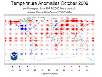
While the U.S. experienced its wettest, and third coolest, October in recorded history, that didn't bear out across the rest of the globe. NCDC indicates, and Dr. Jeff Masters of Weather Underground reports, that last month was the 6th warmest October on record globally. In the U.S., temperatures averaged 4.0F below normal, while precipitation was almost double the typical October average. It appears from the graphic above that outside of the continental U.S., northern Europe was the only other region where temps averaged below normal. In addition, U.S. drought and fire activity both decreased in October.


El Nino Strengthens
According to the Climate Prediction Center's (CPC) weekly El Nino report issued this morning, El Nino conditions have strengthened across the central and eastern Pacific in the past month, with sea surface temperatures now averaging 1.0-2.0 degrees above normal. In fact, the most watched region of the Pacific (dubbed "El Nino 3.4") has now crossed a threshold that allows this El Nino event to be classified a "strong" event. Model forecasts call for moderate to strong El Nino conditions to continue through the 2009-2010 Northern Hemisphere winter. Three-month forecasts for the Mid-South reflect semi-typical El Nino considerations, including slightly below normal temperatures and below normal precipitation. More on the current El Nino conditions can be found here.


Another Winter Forecast
My blogosphere friend Paul Yeager of CloudyandCool.com wrote yesterday about a computer model called the NCEP coupled forecast system (CFS) that has advantages over typical day-to-day models in forecasting long-range (read Paul's blog for a great explanation). In the FWIW category, the CFS output agrees with the CPC and most other winter forecasts that have taken into consideration the effects of El Nino and forecasted cool and dry winter months for the Mid-South. For a look at U.S. temperature forecast maps from the CFS, click here, and for precipitation, click here.


Doppler Ducks
Ryan Vaughan with KAIT-TV in Jonesboro woke up Saturday morning to reports of large flocks of waterfowl (likely geese and some ducks) flying south over northeast AR. As he checked NWS Doppler Radar, he noticed what appeared to be light rain showers headed south over the area (while other returns were moving northeast through north MS). Putting two and two together, it was determined that the migratory birds were showing up on radar! (Read more on Ryan's blog, including a radar loop of the occurrence.)

While a very cool thing to witness, birds on radar is certainly not unprecedented (see my previous blog, "The Birds"). In fact, during certain times of year, at sunrise, "expanding donuts" of radar echoes appear near Reelfoot Lake and other areas around the region known to be excellent sleeping spots for our feathered friends. As the waterfowl take off in all directions, they show up as an ever-expanding ring of echoes.

So hunters, not only will checking the early morning forecast on MemphisWeather.net be helpful in determining the weather conditions for your stakeout, but accessing Doppler radar on MWN Mobile might net you a heads-up to an approaching flock!

----
Become a fan of MemphisWeather.net on Facebook and follow MWN on Twitter!