6/30/10 - 9PM CDT UPDATE:
NATIONAL WEATHER SERVICE DOPPLER RADAR FROM BROWNSVILLE TEXAS AND AIR FORCE RESERVE UNIT HURRICANE HUNTER OBSERVATIONS INDICATE THAT THE EYE OF HURRICANE ALEX MADE LANDFALL AROUND 9 PM CDT... 0200 UTC... ALONG THE COAST OF MEXICO IN THE MUNICIPALITY OF SOTO LA MARINA... ABOUT 110 MI SOUTH OF BROWNSVILLE. MAXIMUM SUSTAINED WINDS AT LANDFALL WERE ESTIMATED TO BE 105 MPH... A CATEGORY TWO HURRICANE ON THE SAFFIR-SIMPSON HURRICANE WIND SCALE.
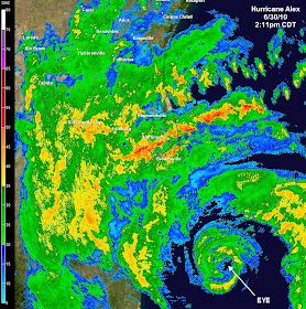
Hurricane Alex, the first Atlantic basin hurricane in the month of June since 1995, is churning towards the Mexican coastline, about 100 miles south of south Texas and the Rio Grande Valley, this afternoon. Radar from mid-afternoon (above, click for larger image) shows that the eye of the category 1 storm is now evident on Brownsville, TX radar.
With about 12 hours left until landfall (expected shortly after midnight tonight Central), time is running out for rapid intensification, though satellite and radar presentations are improving and the central pressure is much more indicative of a stronger hurricane than the wind fields are. The Hurricane Center predicts sustained wind will increase another 10-15 knots, making the storm a category 2 at landfall.
The biggest threat to the U.S., however, will be flooding. Rainfall is expected to be between 6-12", locally up to 20", in south Texas where extreme rain events can easily cause massive flooding due to poor drainage and arid land. A storm surge of 3-5 feet above normal tide levels is also expected in exteme southern TX. The storm itself is so large that it is causing tropical rains and strong thunderstorms all along the Gulf Coast, where 4-6" of rain could fall from Houston to Pensacola.
More information on Alex can be found on the MWN Tropical Weather page, as well as the National Hurricane Center website. Some of the best graphics on the web can be found at StormPulse.com.
----


