Pages

Tuesday, November 30, 2010

Summary of tornado damage from selected Mississippi storms on 11/29/10


Tornadoes struck portions of Mississippi late Monday evening as a potent weather system moved through the region. Thankfully, the severe weather stayed south of the Memphis metropolitan area, however other folks weren't so lucky. The image above shows the warnings issued as the storm system moved through.

Below are storm survey results conducted by the NWS on storms in Monroe County, MS (in the Memphis NWS service area) and Oktibbeha County, home to Starkville and Mississippi State University.

PUBLIC INFORMATION STATEMENT
NATIONAL WEATHER SERVICE MEMPHIS TN
208 PM CST TUE NOV 30 2010

...PRELIMINARY EF-2 TORNADO IN MONROE COUNTY MISSISSIPPI...

* COUNTY/COUNTIES: MONROE.

* LOCATION OF EVENT: 8 MILES SOUTH SOUTHEAST OF AMORY.

* TIME OF EVENT: APPROXIMATELY 1152 PM CST ON NOVEMBER 29 2010.

* BEGINNING POINT: LATITUDE: 33 DEG...52 MIN...36.0 SEC.
LONGITUDE: 88 DEG...27 MIN...45.9 SEC.

* RATING: EF-2.

* ESTIMATED PEAK WIND: APPROXIMATELY 115 MPH.

* PATH LENGTH: 500 YARDS.

* MAXIMUM WIDTH: 125 YARDS.

* FATALITIES: NONE AT THIS TIME.

* INJURIES: 11.

* SUMMARY OF DAMAGES: APPROXIMATELY 20 MANUFACTURED HOMES DAMAGED OR DESTROYED... TREES SNAPPED AND POWER LINES DOWN.

$$


PUBLIC INFORMATION STATEMENT
NATIONAL WEATHER SERVICE JACKSON MS
1230 PM CST TUE NOV 30 2010

COUNTY/COUNTIES: OKTIBBEHA

BEGINNING POINT: 1.5 MILES SW STARKVILLE AT 1108 PM CST

ENDING POINT: STARKVILLE AT 1109 PM CST

RATING: EF2, MAX ESTIMATED WINDS 115 MPH

PATH LENGTH: 1.5 MILES

MAXIMUM WIDTH: 200 YARDS

FATALITIES: 0

INJURIES: SOME MINOR INJURIES

SUMMARY OF DAMAGE: INITIAL DAMAGE WAS ROOF AND SIDING DAMAGE TO A CHURCH ALONG LYNN LANE. THE TORNADO MOVED NORTHEAST THROUGH AN AREA OF APARTMENT BUILDINGS, CAUSING MINOR TO MODERATE ROOF DAMAGE TO A NUMBER OF BUILDINGS, AS WELL AS DOWNING SEVERAL TREES. THE TORNADO THEN MOVED INTO THE PINES TRAILER PARK, WHERE IT DESTROYED A NUMBER OF MOBILE HOMES. TWO LARGE MOBILE HOMES WERE ROLLED AND DESTROYED, AND SEVERAL MOBILE HOMES WERE MOVED A SUBSTANTIAL DISTANCE AND DESTROYED. NUMEROUS LARGE PINE TREES WERE SNAPPED NEAR THE BASE, WITH SEVERAL LANDING ON MOBILE HOMES CAUSING MAJOR DAMAGE. NUMEROUS UTILITY LINES WERE SNAPPED AND DOWNED, AND A COUPLE OF POLES WERE DOWNED. THIS WAS THE LOCATION OF MAXIMUM DAMAGE. THE TORNADO THEN MOVED NORTHEAST ACROSS LOUISVILLE ROAD, CAUSING ROOF DAMAGE TO SEVERAL HOMES AND CONTINUING TO SNAP TREES. IT MOVED THROUGH ANOTHER TRAILER PARK, BLOWING OUT THE SKIRTING ON SEVERAL MOBILE HOMES AND CAUSING MINOR ROOF AND STRUCTURAL DAMAGE TO A COUPLE. AS THE TORNADO PASSED THROUGH THE EAST SIDE OF THE STARKVILLE HIGH SCHOOL COMPLEX, IT TWISTED SOME LIGHT STANDARDS ON THE ATHLETIC FIELDS AND CAUSED SOME MINOR FENCE DAMAGE. IT THEN CROSSED YELLOW JACKET DRIVE, BLOWING OUT A PORCH ON A RESTAURANT AND CAUSING SOME MINOR ROOF DAMAGE. AS IT CROSSED HIGHWAY 12, IT BLEW DOWN A COUPLE OF TRAFFIC LIGHTS, BLEW OUT A BUSINESS SIGN, AND DAMAGED ANOTHER PORCH ON A RESTAURANT. THE TORNADO SNAPPED A FEW TREES AND CAUSED SOME SHINGLE DAMAGE TO A COUPLE OF HOMES ON SOUTH MONTGOMERY STREET, AND THEN APPEARS TO HAVE DISSIPATED. THE TORNADO WAS RATED EF2 BASED ON THE SMALL AREA OF THE MOST INTENSE DAMAGE IN THE PINES TRAILER PARK; THE REMAINDER OF THE DAMAGE WAS GENERALLY EF1 IN NATURE.

In addition, while the survey results are not available yet as of this writing, Accuweather blogger Jesse Ferrell took a look at the preliminary information on an EF-2 tornado that struck Yazoo City, MS last night, along nearly the same track as the EF-4 Yazoo City tornado in April. Here's the post.

----
Get the latest weather conditions and much more by checking out MemphisWeather.net on Facebook and Twitter!

Monday, November 29, 2010

Update on severe weather and flooding risk for today

A strong frontal system is poised to move through the region this evening. Atmospheric conditions are coming together to create the potential for severe weather over the Lower Mississippi River Valley into parts of the Tennessee Valley, including a portion of the Mid-South. In addition, the risk for flooding in low-lying and urban areas remains as well.

The map above shows the SLIGHT RISK area that the Storm Prediction Center will be closely monitoring today. Storms are expected to increase in intensity by mid-afternoon along the western portion of the slight risk area and move slowly east overnight. As you can see, the Memphis area is now encompassed within the slight risk. The most likely time for severe weather in the metro area will be between 4-10 pm with the main risks being damaging thunderstorm wind and isolated tornadoes.

The second map (above) highlights the tornado risk area for today and tonight. As low pressure develops and moves northeast through Arkansas, areas ahead of the low (in the "warm sector"), mainly SE AR, NW LA, and MS, will be at the most risk of seeing tornadoes. The risk extends north into the metro area though as well, just not as high of a threat. The areas within the hatched blue circle have the greatest threat of significant tornadoes.


Finally, this weather system will be quite the rain-maker as well. The last map above shows the expected 12-hour rainfall totals from noon today until midnight tonight. Most of the area should see anywhere from 1-2" of rain, while isolated areas could see higher amounts. This is the reason for the Flash Flood Watch that is in effect, which could be exacerabted by the heavy rain we received last week.

MemphisWeather.net will have full coverage of this developing weather scenario on the web, Twitter (@memphisweather1), and Facebook (MemphisWeather.net). You can also receive severe weather alerts via Twitter for Shelby County by following @shelbyalerts or sign up to receive alerts by e-mail for any metro county as they are issued from the National Weather Service.

Flash Flood Watch in effect tonight


FLOOD WATCH
NATIONAL WEATHER SERVICE MEMPHIS TN
408 AM CST MON NOV 29 2010

...FLASH FLOODING POSSIBLE TONIGHT MAINLY EAST OF THE MISSISSIPPI RIVER...

.UPPER LEVEL MOISTURE WILL SPREAD INTO THE MIDSOUTH TODAY AHEAD OF A STRONG UPPER LEVEL LOW PRESSURE SYSTEM MOVING INTO THE SOUTHERN PLAINS. THIS MOISTURE WILL OVERSPREAD AN INITIALLY DRY AIRMASS NEAR THE SURFACE. NUMEROUS SHOWERS AND A FEW THUNDERSTORMS WILL MOVE IN FROM THE WEST LATE THIS MORNING AND AFTERNOON WITH
GENERALLY LIGHT RAIN AMOUNTS.

LOW LEVEL MOISTURE WILL INCREASE LATE THIS AFTERNOON AHEAD OF AN APPROACHING COLD FRONT. THIS INCREASED MOISTURE WILL GREATEST EAST OF THE MISSISSIPPI RIVER... AND WILL BE SUPPORTIVE OF HEAVY RAIN ALONG AND AHEAD OF AN EASTWARD ADVANCING COLD FRONT.

BY TUESDAY MORNING... RAIN AMOUNTS OF 1 TO 3 INCHES WILL BE POSSIBLE EAST OF THE MISSISSIPPI RIVER.

...FLASH FLOOD WATCH NOW IN EFFECT FROM THIS EVENING THROUGH LATE TONIGHT...

THE FLASH FLOOD WATCH IS NOW IN EFFECT FOR

* PORTIONS OF NORTH MISSISSIPPI AND WEST TENNESSEE... INCLUDING THE FOLLOWING AREAS... IN NORTH MISSISSIPPI... ALCORN... BENTON...CALHOUN... CHICKASAW...COAHOMA...DESOTO... ITAWAMBA... LAFAYETTE... LEE... MARSHALL... MONROE... PANOLA... PONTOTOC... PRENTISS... QUITMAN... TALLAHATCHIE... TATE... TIPPAH... TISHOMINGO... TUNICA... UNION AND YALOBUSHA. IN WEST TENNESSEE... CARROLL... CHESTER... CROCKETT... DECATUR... DYER... FAYETTE... GIBSON... HARDEMAN... HARDIN... HAYWOOD... HENDERSON... HENRY...L AKE... LAUDERDALE... MADISON... MCNAIRY... OBION... SHELBY... TIPTON AND WEAKLEY.

* FROM THIS EVENING THROUGH LATE TONIGHT

* 1 TO 3 INCHES OF RAINFALL POSSIBLE.

* THE HEAVY RAIN MAY CAUSE FLASH FLOODING OF LOW WATER CROSSINGS... LOW LYING AREAS... AND CREEKS.

PRECAUTIONARY/PREPAREDNESS ACTIONS...

A FLASH FLOOD WATCH MEANS THAT CONDITIONS MAY DEVELOP THAT LEAD TO FLASH FLOODING. FLASH FLOODING IS A VERY DANGEROUS SITUATION.

YOU SHOULD MONITOR LATER FORECASTS AND BE PREPARED TO TAKE ACTION SHOULD FLASH FLOOD WARNINGS BE ISSUED.

Saturday, November 27, 2010

Mid-South drought status as November draws to a close

Little has been said in the past month about the drought conditions that impacted the Mid-South (and much of the south-central and southeast U.S. in fact) late this summer and into the fall months. Perhaps because the growing season has ended and we've seen more rain in the past 4 weeks or so, it's no longer a hot topic.

However, the U.S. Drought Monitor still classifies the tri-state area and the Memphis metro as being in a "severe" drought in it's latest weekly release. The Mid-South area map is shown above. After only 4.50" of rain at Memphis International Airport from August 1-October 31, November has seen some welcome relief from the dry spell, with 5.39" of precipitation falling so far this month, which is above average for the month and more than we got in the previous 3 months combined.

There will be one more opportunity to pad November's rainfall total, and it could be a significant one. A storm system will move out of the Rockies Sunday night and tap into moisture from the Gulf of Mexico that increases over the area into Monday. Low pressure will develop over Arkansas and further enhance the rain amounts. We could be looking at precipitation totals of 1.50-2.00" or more between noon Monday and early Tuesday morning as rain could be heavy at times. Flood Warnings are possible - even in an area classified as having "severe drought" conditions. Certainly, November's rain will help as the Mid-South climbs out of the drought conditions of previous months.

----
Get the latest weather conditions and much more by checking out MemphisWeather.net on Facebook and Twitter!

Friday, November 26, 2010

16 years since the Thanksgiving weekend Germantown tornado


In the wake of thunderstorms that rumbled through yesterday along a powerful cold front, it's a good time to remember that November and early December is secondary severe weather season in the Mid-South. The best reminder of this fact though is the Thanksgiving weekend tornado that struck the city of Germantown, TN several years ago. In fact, tomorrow (November 27) marks the 16th anniversary of that destructive and deadly event in which three people from one family lost their lives while gathered for a Thanksgiving celebration at the home of Walter Person, Jr.

Last year at this time, I posted details of the event on the 15th anniversary of the storm, including recapping discussions I had with officials with the Germantown Fire Department who were first responders on that date. I invite you to read (or re-read) the blog post from last year: Remembering the Germantown Tornado, 15 Years Later

You can also see pictures of the event, courtesy of GFD Deputy Fire Chief Edgar Babian, here.

----
Get the latest weather conditions and much more by checking out MemphisWeather.net on Facebook and Twitter!

Wednesday, November 24, 2010

Winter Weather Advisory - just in time for Black Friday

URGENT - WINTER WEATHER MESSAGE
NATIONAL WEATHER SERVICE MEMPHIS TN
355 PM CST WED NOV 24 2010

...FIRST TASTE OF WINTER WILL ARRIVE THURSDAY EVENING...

.AN ARCTIC COLD FRONT WILL PASS THROUGH THE MIDSOUTH THURSDAY AND EARLY THURSDAY EVENING. A SHALLOW BUT MUCH COLDER AIRMASS WILL FOLLOW THE FRONT. PRECIPITATION SHOULD LAG THROUGH THE EVENING HOURS BEHIND THE FRONT... THEREFORE A TRANSITION FROM RAIN TO A MIXTURE OF SNOW AND SLEET IS EXPECTED FROM NORTHWEST TO SOUTHEAST THROUGH THE EVENING AND EARLY OVERNIGHT. ABOUT A 3 HOUR BURST OF WINTRY PRECIPITATION IS EXPECTED. DUE TO THE WARM GROUND... LITTLE IF ANY ACCUMULATIONS ARE EXPECTED IN MOST PLACES... BRIDGES AND OVERPASSES AND LESS TRAVELED ROADS MOST PRONE TO FREEZING MAY ALLOW FOR SOME ACCUMULATION.


THE NATIONAL WEATHER SERVICE IN MEMPHIS HAS ISSUED A WINTER WEATHER ADVISORY FOR SNOW AND SLEET... WHICH IS IN EFFECT FROM 9 PM THURSDAY TO 3 AM CST FRIDAY.

* ONLY MINOR SNOW AND SLEET ACCUMULATIONS ARE EXPECTED... HOWEVER MUCH COLDER AIR BEHIND AN ARCTIC COLD FRONT COULD FREEZE BRIDGES AND SECONDARY ROADS... ALLOWING FOR MORE ROBUST ACCUMULATION OF SNOW AND SLEET ON THOSE SURFACES.

* RAIN WILL TRANSITION TO SNOW AND SLEET BETWEEN 9 PM AND MIDNIGHT THURSDAY EVENING AND GRADUALLY TAPER OFF BY 3 AM.

* SECONDARY ROADS AND BRIDGES AND OVERPASSES MAY BECOME QUITE SLICK THURSDAY NIGHT.

PRECAUTIONARY/PREPAREDNESS ACTIONS...

A WINTER WEATHER ADVISORY MEANS THAT PERIODS OF SNOW... SLEET... OR FREEZING RAIN WILL CAUSE TRAVEL DIFFICULTIES. BE PREPARED FOR SLIPPERY ROADS AND LIMITED VISIBILITIES... AND USE CAUTION WHILE DRIVING.

Tuesday, November 23, 2010

Winter weather on Black Friday - as welcome as your mother-in-law at the Thanksgiving table

So the doom and gloom forecasts have been issued and widespread panic is beginning to set in as Thanksgiving travelers and Black Friday shoppers decide whether to adjust their plans (or at least what to plan for) weather-wise. Here's the official take on the forecast from MemphisWeather.net:

I'll skip briefly through the next 36 hours... a warm front moves through early tomorrow (Wednesday) with scattered showers and a few thunderstorms during the morning, then things warm up into the 70s by afternoon and stay unseasonably warm Wednesday night with a steady (at times gusty) wind. Early Thursday, before dawn, that warm front makes one more run at the Mid-South as a cold front as it gets shoved east by a modified arctic airmass that dives south into the Mid-Mississippi Valley. The front will move through during the day on Thanksgiving, bringing with it a main course of moderate to heavy rain, a side of thunder and another of gusty north wind, and for dessert - quickly falling temperatures. The meal will be served during the afternoon hours.

The overnight period is the trickiest and computer models continue to disagree like in-laws around the Thanksgiving table. As rain continues to fall during the evening, temperatures will also fall, likely reaching the 30s by midnight. Sometime around then, rain will taper off as temperatures start to reach a crucial level - the lower 30s. As of right now, it is possible that the Memphis metro area could see a little light freezing drizzle or rain, snow flurries, or light sleet for a couple of hours between midnight and about 5am Friday - or roughly during the biggest doorbuster sales of the day. I can just it see it now... but I digress. I DO NOT expect to see any accumulations of wintry mess in the metro area, but perhaps some camped-out plastic toy needers will get a boost of Christmas mood by seeing a snowflake or two. Let's not call it Black Ice Friday just yet though OK?

After dawn Friday, I expect to see clouds quickly depart, leaving behind temperatures that will feel as cool as leftover turkey just removed from the refrigerator. Moderating temperatures are expected over the weekend. Have a great Thanksgiving - and stay with MemphisWeather.net for the latest.

----
Get the latest weather conditions and much more by checking out MemphisWeather.net on Facebook and Twitter!

Sunday, November 21, 2010

Thanksgiving Week forecast discussion


With one of the biggest travel weeks of the year coming up and plenty of celebrations planned, there is certainly more interest in the weather forecast than usual. It doesn't help that long-range forecasts to this point have been pointing towards a wet scenario and major temperature swings. Now that the first half of the week and Thanksgiving holiday are moving into the "shorter range" of the forecast, what does the Mid-South have in store? Glad you asked... as the Facebook relationship status says, "it's complicated."

Unfortunately, computer models are not doing a good job of painting a clear picture, making for less confidence in the forecast than we meteorologists typically like to see for holiday weeks. A frontal system will be making what appears to be two passes at us this week. Ahead of the front, abnormally mild conditions will continue on Monday with highs in the 70s and windy weather continuing. As the front will be closer to the region, a slight chance of a shower or thunderstorm appears in the forecast. By Monday night, that cold front approaches and then moves through the metro area on Tuesday. That will mean rain and thunderstorms will be likely during that time frame.

This is where things get tricky. How far south the front moves will determine rain chances Tuesday afternoon and night. One thing is fairly clear - sometime Wednesday (probably early), that front will return as a warm front as low pressure developing to the west drags the front back north. This puts the Mid-South back in the "warm sector" with more scattered showers and thunderstorms possible Wednesday - one of the biggest travel days of the year.

Up until today, I had forecast the front to finally move all the way through the region by Wednesday night, bringing in much cooler weather, but ending the rain chances by Thanksgiving. Now I am much less convinced and am hedging towards the front making it's last move through the region on Thanksgiving Day, accompanied by the potential for rain and thunderstorms, some of which could be heavy as a strong surge of Canadian air pushes in behind the front. There is still plenty of time for things to change, but as of now that is my best forecast. This will delay the very cold air, so Thanksgiving Day may not be as chilly as previously thought, but Black Friday could be the coldest day of the fall to this point with highs in the 40s. Moderation in temperatures is expected next weekend and behind this front I expect the weekend itself to be dry.

Stay tuned into the MemphisWeather.net forecast for the latest in expected conditions for Thanksgiving week. I'll also be posting updates on Facebook and Twitter throughout the week.

----
Get the latest weather conditions and much more by checking out MemphisWeather.net on Facebook and Twitter!

Winter Weather Awareness Week 2010 - Safety rules for your home

PUBLIC INFORMATION STATEMENT
NATIONAL WEATHER SERVICE MEMPHIS TN
600 AM CST FRI NOV 19 2010

...WINTER WEATHER AWARENESS IN THE MID SOUTH...

NOVEMBER 15TH THROUGH 19TH IS WINTER WEATHER AWARENESS WEEK IN THE MID SOUTH. PEOPLE ARE ASKED TO TAKE SOME TIME AND PREPARE FOR THE UPCOMING WINTER SEASON.

TODAYS TOPIC IS WINTER WEATHER SAFETY RULES FOR YOUR HOME.

THE BEST WAY TO SURVIVE A WINTER STORM IS TO PLAN AND PREPARE FOR THE HAZARDS OF WINTER WEATHER. ALTHOUGH SOME WINTER STORMS DEVELOP QUICKLY AND WITH SHORT NOTICE... MOST EVENTS CAN BE PLANNED FOR.

AT HOME... THE PRIMARY CONCERNS ARE FOR THE POTENTIAL LOSS OF POWER... HEAT AND TELEPHONE SERVICE. FOOD SUPPLIES MAY ALSO RUN LOW IF CONDITIONS PERSIST FOR SEVERAL DAYS. SOME ITEMS THAT SHOULD BE READILY AVAILABLE AROUND THE HOME PRIOR TO THE ONSET OF WINTER WEATHER INCLUDE...

-EXTRA FOOD AND WATER...ESPECIALLY CANNED GOODS
-A FLASHLIGHT WITH EXTRA BATTERIES
-FIRST-AID SUPPLIES AND EXTRA MEDICINE
-EXTRA BABY ITEMS
-EXTRA WOOD FOR EMERGENCY HEATING
-A BATTERY POWERED NOAA WEATHER RADIO AND PORTABLE RADIO

IF POWER IS LOST... NEVER USE A GASOLINE OR DIESEL POWERED GENERATOR INSIDE THE HOUSE... IN THE GARAGE... OR ANY OTHER ENCLOSED SPACE. GENERATORS CAN CAUSE CARBON MONOXIDE TO BUILD UP TO DEADLY LEVELS IN ENCLOSED SPACES. OPERATE SUCH GENERATORS OUTDOORS ONLY.

ANOTHER WINTER THREAT IS HOUSE FIRES. DECEMBER... JANUARY... AND FEBRUARY ARE THE LEADING MONTHS FOR HOUSE FIRES IN THIS COUNTRY. MORE THAN ONE-THIRD OF FIRE DEATHS TYPICALLY OCCUR DURING THE WINTER MONTHS.

HERE ARE SOME PRECAUTIONS YOU CAN TAKE...

-CENTRAL HEATING SYSTEMS SHOULD BE KEPT IN PROPER WORKING
ORDER. THIS INCLUDES REGULAR INSPECTIONS.
-SPACE HEATERS NEED TO BE AT LEAST 36 INCHES AWAY FROM ANY
FLAMMABLE MATERIALS. THE HEATERS SHOULD NOT BE LEFT ON
WHEN NO ONE IS PRESENT OR WHEN PEOPLE ARE ASLEEP. THE
HEATERS SHOULD HAVE AUTOMATIC SHUT-OFF SWITCHES THAT TURN
THE UNIT OFF IF IT TIPS OVER.
-FIREPLACES AND CHIMNEYS SHOULD BE INSPECTED AND CLEANED ON
A REGULAR BASIS. THE FIREPLACES SHOULD HAVE A STURDY SCREEN...
AND ONLY WOOD SHOULD BE BURNED.
-WOOD STOVES SHOULD BE INSTALLED...USED...AND MAINTAINED IN
ACCORDANCE WITH INSTRUCTIONS FROM THE MANUFACTURER. USE OF
A STOVE BOARD WILL PROTECT THE FLOOR. ONLY WOOD SHOULD BE
BURNED IN THE STOVE.
-KITCHEN RANGES AND OVENS... CHARCOAL GRILLS... AND HIBACHIS
SHOULD NEVER BE USED FOR HEATING.
-CARBON MONOXIDE IS ANOTHER HAZARD. IT IS A COLORLESS...
ODORLESS GAS AND IS PRODUCED BY GAS-FIRED APPLIANCES...
CHARCOAL GRILLS... AND WOOD-BURNING FURNACES AND FIREPLACES.
CARBON MONOXIDE ALARMS SHOULD BE INSTALLED TO PROVIDE AN
EARLY WARNING WHEN THE GAS BEGINS TO BUILD UP.

$$

Thursday, November 18, 2010

Winter Weather Awareness Week 2010 - Precipitation Types

PUBLIC INFORMATION STATEMENT
NATIONAL WEATHER SERVICE MEMPHIS TN
600 AM CST THU NOV 18 2010

...WINTER WEATHER AWARENESS IN THE MID SOUTH...

NOVEMBER 15TH THROUGH 19TH IS WINTER WEATHER AWARENESS WEEK IN THE MID SOUTH. PEOPLE ARE ASKED TO TAKE SOME TIME AND PREPARE FOR THE UPCOMING WINTER SEASON.

TODAYS TOPIC IS WINTER PRECIPITATION TYPES.

SNOW -- SNOW FORMS IN THE CLOUDS AND REMAINS AS SNOW ALL THE WAY TO THE GROUND. IT MOST COMMONLY TAKES THE FORM OF SNOWFLAKES... WHICH ARE THE FAMILIAR SIX-SIDED ICE CRYSTALS. IT MAY ALSO FALL IN THE FORM OF SNOW PELLETS OR SNOW GRAINS.

SNOW FLURRIES ARE MOST COMMONLY SEEN AS A FEW SNOWFLAKES FALLING... ALTHOUGH VISIBILITIES CAN BE REDUCED AT TIMES. IN THE MID SOUTH... THE TERM SNOW FLURRIES IS USED TO INDICATE THAT NO ACCUMULATION IS EXPECTED.

SNOW SHOWERS IS A TERM NOT OFTEN USED IN THE MID SOUTH. IN THIS TYPE OF PRECIPITATION... THE SNOW FALLS AT VARYING INTENSITIES OVER BRIEF PERIODS OF TIME. ACCUMULATION MAY OCCUR... ESPECIALLY DURING MODERATE TO HEAVY SNOW SHOWERS.

BLOWING SNOW MOST COMMONLY REFERS TO SNOW THAT IS ALREADY ON THE GROUND AND IS LIFTED INTO THE AIR BY THE WIND.

IN THE MID SOUTH... HEAVIER SNOWS MOST COMMONLY OCCUR WHEN COLD AIR IS ALREADY IN PLACE OVER THE REGION AND A STRONG UPPER LEVEL LOW PRESSURE SYSTEM MOVES OUT OF THE SOUTHWESTERN UNITED STATES. THE LOW SERVES TO PULL MOIST AIR NORTHWARD INTO THE COLD AIR. LIGHT SNOW OR SNOW FLURRIES CAN ALSO OCCUR IN THE COLD AIR THAT FOLLOWS THE PASSAGE OF AN ARCTIC COLD FRONT.

SLEET - SLEET CONSISTS OF PELLETS OF ICE. IN FACT... FOR PEOPLE WHO HAVE TROUBLE WITH THE DIFFERENCE BETWEEN SLEET AND FREEZING RAIN... IT MAY BE EASIER TO ASSOCIATE SLEET WITH ITS TECHNICAL NAME... WHICH IS ICE PELLETS. FOR SLEET TO FORM...SNOW BEGINS FALLING FROM THE CLOUDS BUT THEN GOES THROUGH A LAYER OF ABOVE-FREEZING AIR THOUSANDS OF FEET ABOVE THE GROUND. THIS CAUSES THE SNOW TO CHANGE TO RAIN. THEN... THE RAIN GOES THROUGH A LAYER OF BELOW-FREEZING AIR... USUALLY AT LEAST TWO TO THREE THOUSAND FEET THICK... AND THE PRECIPITATION TURNS INTO PELLETS OF ICE.

SLEET TYPICALLY OCCURS IN A FAIRLY NARROW BAND. THIS BAND USUALLY MOVES... BUT AT TIMES MAY REMAIN NEARLY STATIONARY... RESULTING IN ACCUMULATIONS OF SLEET.

IN THE MID SOUTH... SLEET MOST COMMONLY OCCURS IN A NARROW BAND BETWEEN AN AREA OF RAIN TO THE SOUTH AND AN AREA OF SNOW TO THE NORTH.

FREEZING RAIN -- THIS WEATHER PHENOMENON IS SOMETIMES CALLED GLAZE... BECAUSE OF THE GLAZE OF ICE IT PUTS ON SURFACES AT THE GROUND. FREEZING RAIN MOST COMMONLY OCCURS WHEN PRECIPITATION FALLS FROM THE CLOUDS AS SNOW... THEN GOES THROUGH AN ABOVE-FREEZING LAYER... WHICH TURNS THE PRECIPITATION TO RAIN. THEN... THE RAIN REACHES THE GROUND WHERE TEMPERATURES ARE BELOW FREEZING. THE RAIN THEN FREEZES AS IT HITS EXPOSED OBJECTS. IN THE WORST CASES... EVERYTHING BECOMES COATED WITH A LAYER OF ICE.

IN THE MID SOUTH... FREEZING RAIN COMMONLY OCCURS AS AN ARCTIC HIGH PRESSURE SYSTEM BEGINS TO MOVE AWAY FROM THE STATE. IN THIS SITUATION... COLD AIR IS STILL LINGERING AT THE GROUND... BUT WARMER SOUTHERLY WINDS FROM THE GULF OF MEXICO BEGIN BRINGING MOISTURE BACK OVER THE TOP OF THE COLD AIR. SINCE THE AIR AT THE GROUND HAS NOT WARMED ABOVE FREEZING... THE RAIN THAT FALLS FREEZES ON THE GROUND AND OTHER OBJECTS. FREEZING RAIN... AND ITS COUSIN FREEZING DRIZZLE... OFTEN DEVELOP DURING THE LATE NIGHT HOURS... CREATING ICY CONDITIONS FOR MORNING RUSH HOUR.

FREEZING FOG -- WHILE THIS IS NOT PRECIPITATION FALLING FROM THE CLOUDS... IT IS ANOTHER WINTER WEATHER HAZARD. FREEZING FOG TYPICALLY DEVELOPS ON CLEAR... CALM NIGHTS WHEN TEMPERATURES ARE BELOW FREEZING. FOG FORMS AND FREEZES... USUALLY ON BRIDGES... OVERPASSES... AND OTHER ELEVATED ROADWAYS. IT CAN CREATE QUITE A SURPRISE FOR MOTORISTS... DUE TO THE PRESENCE OF CLEAR SKIES OVERHEAD.

FROST -- FROST DESCRIBES THE FORMATION OF THIN ICE CRYSTALS ON THE GROUND OR OTHER SURFACES IN THE FORM OF SCALES... NEEDLES... FEATHERS... OR FANS. FROST FORMS WHEN WATER VAPOR IN THE AIR TURNS DIRECTLY TO ICE CRYSTALS ON AN OBJECT. THE TEMPERATURE OF THE OBJECT MUST BE BELOW FREEZING FOR FROST TO OCCUR. HOWEVER... FROST IS SOMETIMES SEEN ON THE GROUND WHEN OFFICIAL TEMPERATURES ARE REPORTED TO BE ABOVE FREEZING. THIS IS BECAUSE THE OFFICIAL TEMPERATURE IS TAKEN ABOUT FIVE FEET ABOVE THE GROUND... WHERE THE AIR CAN BE A FEW DEGREES WARMER THAN THE TEMPERATURE AT GROUND LEVEL.

$$

Wednesday, November 17, 2010

Winter Weather Awareness Week 2010 - Winter Travel

PUBLIC INFORMATION STATEMENT
NATIONAL WEATHER SERVICE MEMPHIS TN
600 AM CST WED NOV 17 2010

...WINTER WEATHER AWARENESS IN THE MID SOUTH...

NOVEMBER 15TH THROUGH 19TH IS WINTER WEATHER AWARENESS WEEK IN THE MID SOUTH. PEOPLE ARE ASKED TO TAKE SOME TIME AND PREPARE FOR THE UPCOMING WINTER SEASON.

TODAY WE WILL FOCUS ON WINTER WEATHER TRAVEL TIPS AND SAFETY RULES.

THANKSGIVING IS JUST AROUND THE CORNER AND OTHER HOLIDAY TRAVEL IS COMING SOON. NOW IS A GOOD TIME FOCUS ON WINTER TRAVEL.

ABOUT 70 PERCENT OF DEATHS LINKED TO WINTRY WEATHER HAPPEN IN AUTOMOBILES. HERE ARE SOME TIPS TO HELP FROM BEING PART OF THAT WOEFUL STATISTIC...

MAKE CHECKING THE LATEST WEATHER REPORTS PART OF YOUR TRAVEL PLANS SO YOU CAN AVOID STORMS.

CARRY A NOAA WEATHER RADIO ALONG TO TUNE INTO LOCAL WEATHER INFORMATION 24 HOURS A DAY.

FULLY CHECK AND WINTERIZE YOUR VEHICLE BEFORE THE WINTER SEASON BEGINS.

CARRY A WINTER STORM SURVIVAL KIT IN YOUR CAR. THE KIT SHOULD INCLUDE ...

1. BLANKETS OR SLEEPING BAGS
2. A FLASHLIGHT WITH EXTRA BATTERIES
3. A FIRST AID KIT
4. A KNIFE
5. SOME HIGH-CALORIE, NON-PERISHABLE FOOD
6. EXTRA CLOTHING TO KEEP DRY
7. A LARGE EMPTY CAN AND PLASTIC COVER WITH TISSUES AND PAPER TOWELS FOR SANITARY PURPOSES
8. A SMALLER CAN AND WATER-PROOF MATCHES TO MELT SNOW FOR DRINKING WATER
9. A SACK OF SAND OR CAT LITTER FOR TRACTION
10. A SHOVEL
11. A WINDSHIELD SCRAPER AND BRUSH
12. A TOOL KIT FOR EMERGENCY REPAIRS
13. A TOW ROPE
14. BATTERY BOOSTER CABLES
15. A CLEAN WATER CONTAINER
16. A COMPASS AND ROAD MAPS.

KEEP YOUR GAS TANK NEAR FULL TO AVOID ICE IN THE TANK AND FUEL LINES. TRY NOT TO TRAVEL ALONE. LET SOMEONE KNOW YOUR TIMETABLE AND PRIMARY AND ALTERNATE ROUTES.

A LAST REMINDER... A WINTER STORM WATCH MEANS THAT WINTER WEATHER IS POSSIBLE... A WINTER STORM WARNING IS WHEN WINTER WEATHER HAS BEGUN OR IS ABOUT TO BEGIN. START YOUR PREPARATIONS NOW FOR THE SAFEST WINTER SEASON POSSIBLE AND STAY TUNED TO THE FORECAST.

WE WANT THIS AND ALL WINTER SEASONS TO BE THE SAFEST POSSIBLE. IF YOU HAVE QUESTIONS ABOUT THIS OR ANY WEATHER RELATED QUESTIONS... FEEL FREE TO CONTACT THE NATIONAL WEATHER SERVICE OFFICE IN MEMPHIS OR E-MAIL US AT MEMPHISWEATHER.NET AT WEBMASTER(AT)MEMPHISWEATHER(DOT)NET.

$$

Tuesday, November 16, 2010

Winter Weather Awareness Week 2010 - Frostbite and Hypothermia

PUBLIC INFORMATION STATEMENT
NATIONAL WEATHER SERVICE MEMPHIS TN
600 AM CST TUE NOV 16 2010

...WINTER WEATHER AWARENESS IN THE MID SOUTH...

NOVEMBER 15TH THROUGH 19TH IS WINTER WEATHER AWARENESS WEEK IN THE MID SOUTH. PEOPLE ARE ASKED TO TAKE SOME TIME AND PREPARE FOR THE UPCOMING WINTER SEASON.

TODAYS TOPIC IS FROSTBITE AND HYPOTHERMIA.

FROSTBITE CAUSES NUMBNESS AND WHITE OR BLUE TINTED SKIN AND OCCURS MOST COMMONLY IN THE FINGERS... TOES... EARS... AND NOSE.

HYPOTHERMIA... AN ABNORMALLY LOW BODY CORE TEMPERATURE... IS CAUSED BY PROLONGED EXPOSURE TO COLD. HYPOTHERMIA CAN OCCUR INDOORS AS WELL AS OUTSIDE. BODY FUNCTIONS SLOW TO A DANGEROUSLY LOW LEVEL. SYMPTOMS INCLUDE SLURRED SPEECH... INCOHERENCE... DROWSINESS... POOR COORDINATION... A SLOW HEART BEAT... UNCONTROLLABLE SHIVERING OR NO SHIVERING AT ALL.

TO AVOID HYPOTHERMIA... KEEP YOUR CLOTHES DRY. WET CLOTHING LOSES ALL INSULATING VALUE AND SHOULD BE CHANGED AS QUICKLY AS POSSIBLE.

MITTENS AND A WARM HAT ARE NECESSITIES. THE BODY LOSES ABOUT 50 PERCENT OF ITS HEAT THROUGH THE HEAD... SO WHETHER YOU ARE OUTDOORS OR INSIDE AN UNHEATED HOME... DAY OR NIGHT... A HAT WILL GO A LONG WAY IN HELPING YOU STAY WARM.

WIND CHILL IS BASED ON THE RATE OF HEAT LOSS FROM EXPOSED SKIN CAUSED BY THE COMBINED EFFECTS OF WIND AND COLD. AS THE WIND INCREASES... HEAT IS CARRIED AWAY FROM THE BODY... DRIVING DOWN THE BODY TEMPERATURE. REMEMBER THAT ANIMALS ARE AFFECTED BY WIND CHILL AS WELL.

AVOID OVEREXERTION... SUCH AS SHOVELING HEAVY SNOW OR WALKING IN DEEP SNOW. THE STRAIN FROM THE COLD AND HARD LABOR MAY CAUSE A HEART ATTACK. WEAR LOOSE... LIGHT-WEIGHT... WARM CLOTHING IN SEVERAL LAYERS. TRAPPED AIR IS AN INSULATOR. LAYERS CAN BE REMOVED TO AVOID PERSPIRATION AND SUBSEQUENT CHILL. OUTER GARMENTS SHOULD BE WATER REPELLENT AND HOODED. ALWAYS COVER YOUR HEAD... AS YOU CAN LOSE HALF OF YOUR BODY HEAT THROUGH AN UNCOVERED HEAD. BE PREPARED FOR THE STORM BY LISTENING TO NOAA WEATHER RADIO... COMMERCIAL RADIO OR TELEVISION FOR THE LATEST WINTER STORM ADVISORIES.

Winter Weather Awareness Week 2010 - Watches and Warnings

...WINTER WEATHER AWARENESS IN THE MID SOUTH...

NOVEMBER 15TH THROUGH 19TH IS WINTER WEATHER AWARENESS WEEK IN THE MID SOUTH. PEOPLE ARE ASKED TO TAKE SOME TIME AND PREPARE FOR THE UPCOMING WINTER SEASON.

OVER THIS WEEK WE WILL BRING UP A FEW WINTER WEATHER ISSUES AND WAYS TO AVOID DANGEROUS SITUATIONS. DURING EACH WEEKDAY... A DIFFERENT WINTER WEATHER TOPIC WILL BE COVERED IN A PUBLIC INFORMATION STATEMENT...

TODAY...WINTER WEATHER WATCHES...AND WARNINGS
TUESDAY...FROSTBITE...AND HYPOTHERMIA
WEDNESDAY...WINTER WEATHER TRAVEL TIPS AND SAFETY RULES
THURSDAY...WINTER PRECIPITATION TYPES
FRIDAY...WINTER SAFETY FOR YOUR HOME

HERE ARE A FEW TERMS THE NATIONAL WEATHER SERVICE USES WITH WINTER WEATHER.

WINTER STORM WATCH...
A WINTER STORM WATCH MEANS THAT DANGEROUS WINTER WEATHER IS POSSIBLE AND YOU NEED TO BE ALERT TO CHANGING WEATHER CONDITIONS AND AVOID UNNECESSARY TRAVEL.

WINTER STORM WARNING...
A WINTER STORM WARNING MEANS SEVERE WINTER WEATHER HAS BEGUN OR ARE ABOUT TO BEGIN IN YOUR AREA. STAY INDOORS DURING THE STORM. IF YOU MUST GO OUTDOORS... SEVERAL LAYERS OF LIGHTWEIGHT CLOTHING WILL KEEP YOU WARMER THAN A SINGLE HEAVY COAT. WEARING GLOVES AND A HAT WILL PREVENT LOSS OF BODY HEAT. COVER YOUR MOUTH TO PROTECT YOUR LUNGS. UNDERSTAND THE HAZARDS OF WINDCHILL. WALK CAREFULLY ON SNOWY... ICY SIDEWALKS.

THE NATIONAL WEATHER SERVICE REMINDS YOU TO BE PREPARED BEFORE WINTER STORMS STRIKE. HAVE EXTRA BATTERIES FOR FLASHLIGHTS... FOOD AND WATER... EXTRA MEDICATION... FIRST-AID SUPPLIES... AND BLANKETS FOR ADDITIONAL WARMTH AVAILABLE IN CASE OF EMERGENCIES. BE READY FOR WINTER STORMS BY LISTENING TO NOAA WEATHER RADIO OR YOUR LOCAL NEWS STATION.

DURING WINTER STORM EMERGENCIES... STAY TUNED TO NOAA WEATHER RADIO FOR INFORMATION AND EMERGENCY INSTRUCTIONS. POST EMERGENCY TELEPHONE NUMBERS BY THE PHONE AND KEEP ENOUGH SUPPLIES IN YOUR HOME TO MEET YOUR NEEDS FOR AT LEAST THREE DAYS. PREPARE FOR WINTER WEATHER BEFORE IT ARRIVES.

Chilly rain today, but more warmth on the horizon

The Mid-South is in the midst of a fairly active period weather-wise. Strengthening low pressure that originated in the western Gulf of Mexico yesterday is moving just to the east of the metro area this morning and will quickly depart the area by this evening, taking the rain and clouds with it. Another low pressure system diving out of the northern Rockies will pass by to our north Wednesday evening. Between these systems, a breezy but warmer day is expected Wednesday. With the passage of the Wednesday evening cold front, a few light showers could develop, but most areas will likely just see clouds from late afternoon through late evening. Cool air of Pacific origin will keep temperatures on Thursday cool once again.

Beginning Friday, another period of pleasantly warm weather begins as high pressure builds over the southeastern U.S. Southwesterly wind will help temperatures warm into the 60s Saturday and near 70 Sunday, making for a very nice weekend! This pattern will continue into early next week. Currently, long-range models are indicating that this nice weather will come to an abrupt end around Thanksgiving Day as a strong cold front moves through, bringing much cooler temperatures (more typical of late November) and a decent shot at rain. This is still beyond the range of the MWN Extended Forecast, so we'll continue to monitor. Given the time of year, it's definitely reasonable though that the 70 degree weather will not last forever - it's just a matter of exactly when and how hard it comes crashing down!

----
Get the latest weather conditions and much more by checking out MemphisWeather.net on Facebook and Twitter!

Saturday, November 13, 2010

After the rain... a beautiful sunset as clouds depart


A brief post to share some sunset photos I took around 5:00 this evening. A welcome rain brought roughly a quarter-inch of precipitation to the region this morning with cloudy skies behind the cold front this afternoon. Temperatures fell from near 60 this morning to near 50 by late in the afternoon. Clouds began clearing out just in time for a gorgeous sunset.

----
Get the latest weather conditions and much more by checking out MemphisWeather.net on Facebook and Twitter!

Wednesday, November 10, 2010

Contrails: worth a closer look


I found myself gazing at the sky this morning, taking particular notice of the contrails that marked the lanes of mid-air expressways used by commercial jetliners as they criss-cross the countryside. Above is a picture I snapped from the area near Memphis International Airport at about 8:30am. The contrails were aligned generally east-southeast to west-northwest, or along a "highway in the sky" that connects Memphis to Atlanta. I decided this might be a good opportunity to provide a little background on what contrails are and how they form and dissipate, since weather plays an important role in these processes.

Contrails, short for "condensation trails," are trails of millions of tiny ice crystals formed by the exhaust of jet engines mounted on aircraft. When the hot and humid air from a jet engine mixes with surrounding air that is much colder and of lower pressure, the exhaust forces the humidity of that air to rise and condense, similar to the way clouds form. It is similar to the process that causes one to "see their breath" on very cold days.

At very cold temperatures, a trigger is required for condensation to take place and exhaust particles serve as that triggering mechanism (ice nuclei), forming artificial clouds of condensed water vapor. Also at very cold temperatures, the water vapor that is created rapidly freezes, creating the ice crystals that are visible as contrails. It is interesting that contrails will generally only form above about 26,000 feet (almost 5 miles - an altitude at which most commercial jets traveling an hour or more to their destination easily reach) and when the air temperature drops to -40 F (also, -40 C) [CIMSS, UW-Madison]. At the time of the picture above, the temperature was -40F at an altitude of approximately 32,000 feet (6 miles) over Memphis, so the contrails above were created by aircraft flying at or above that level.

Another interesting contrail picture is shown below. This one was sent to MemphisWeather.net by a SKYWARN spotter in northeast Mississippi, who happened to spot, and photograph, a Delta airliner flying overhead with one engine out. It is fairly obvious that this is the case when looking at the single contrail behind the airplane. (There were no reports of aircraft mishaps on that day, so it obviously landed safely.)


As for dissipation, contrails can last anywhere from just a few seconds to hours and can remain as narrow as a 6-mile high tightrope or spread out to become a blanket of cirrus clouds covering a large area. How long they last and whether they spread out or distort in shape depends on the humidity of the air they reside in and the wind direction and speed at the level of the jetliner producing them. The drier the air is at the level contrails are created, the shorter their duration. Drier, less humid air tends to "absorb" the humid contrail more quickly than humid air as it mixes with the drier environment, thus dissipating more quickly.

In very dry air, the contrail may disappear just after being created. If the air is moist and the contrail remains in the sky for a long period of time, then the wind has an opportunity to act on the contrail. If the wind at that level is calm, the contrail remains intact or drifts slowly without spreading. If the wind is blowing strongly, which is more typical at 30-35,000 feet, than the contrail will move more quickly in the direction the wind is blowing and likely spread out and become diffuse as it forms an artificial cirrus canopy. Changes in wind speed (turbulence) can be noted if the contrail snakes across the sky.

Check out the picture below, courtesy of NASA, of a satellite picture of contrails traversing the southeastern U.S. during ideal conditions. It's pretty easy to tell from this image where the higher moisture resides at the upper levels of the atmosphere. It's not that there are no planes over northern South Carolina/Georgia or Tennessee, the air is simply drier and they have dissipated. The presence of cirrus clouds (very thin light grey in the areas where contrails exist) also indicates upper-level moisture. This would explain why many times contrails tend to last longer when there are also cirrus clouds in the area. Crystal clear skies tend to not support long contrails as the air is typically drier.

The contrail topic is timely due to a recent "mystery contrail" off the coast of Los Angeles (see still image from video below) that is now being hypothesized to be that of a commercial jet. I'm not certain at this point, but it definitely is some sort of vapor trail (video of the contrail from KCBS in L.A.). The video at first appears to show a missile, rocket, or other projectile traveling up and away from the camera angle, however an excellent write-up, with many similar examples, on ContrailScience.com tends to support the jet contrail hypothesis - specifically that of America West flight 808 from Honolulu to Phoenix, which would have been traveling inbound to the L.A. Basin.


----
Get the latest weather conditions and much more by checking out MemphisWeather.net on Facebook and Twitter!

Tuesday, November 9, 2010

End of the growing season; pleasant weather won't last long!

Our recent bout of cold weather has ended and high pressure positioned just to our east is allowing warmer air from the south to blanket the region this week. We will enjoy afternoon temperatures in the 70s through Friday with a few clouds but no rain. Overnight lows are also moderating, from the sub-freezing mark over the weekend back into the 40s and some lower 50s by tomorrow morning. More details can be found in the MWN Forecast.

The very cold morning lows over the weekend officially brought an end to the growing season - a term more familiar to those in agriculture than the general public. It is still a useful way to gauge the length of the "warm" season though. The growing season is defined as the period between the last spring freeze and the first fall freeze. This year, the last 32-degree reading in the spring (at Memphis International) was March 5 and we hit 32 for the first time this fall on Saturday morning, November 6 (a few days earlier than average). Thus, the growing season was 245 days long, or 13 days longer than the climatological average. If you are a farmer, that is good news, though I am pretty sure the flooding in April/May, late summer drought, and extreme heat of the summer probably did more to harm the crops than a little longer growing season might have helped!

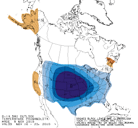
Looking ahead, the overall weather pattern changes again this weekend and we say good-bye to the 70s for a while. A fairly strong cold front will move through on Saturday, dropping highs by 15 degrees or so and ushering in a decent chance of rain Saturday. After Saturday, the computer models diverge and the solution is not as clear, but what is known is that there will be more clouds and possibly rain chances heading into next week and temperatures will be much cooler for the week before Thanksgiving. The NWS is expecting the same thing - take a look at the 8-14 day temperature outlook below! It appears temps across much of the continental U.S. will be well below normal and there is a 60%+ chance that temperatures in the Mid-South will average below normal for the week of Nov. 16-22. Enjoy the warmer weather this week while you have it!

8-14 Day Temperature Outlook
----
Get the latest weather conditions and much more by checking out MemphisWeather.net on Facebook and Twitter!

Thursday, November 4, 2010

International Space Station captures Memphis at night

Can you find the city of Memphis in this "night lights" image taken from the International Space Station on October 29, 2010? The answer is posted below. Click either image for a larger version. (Hint: one of the brightest cities in this image is New Orleans.)


For more information on the photo, click this link from NASA.

----
Get the latest weather conditions and much more by checking out MemphisWeather.net on Facebook and Twitter!

Wednesday, November 3, 2010

Damp, then chilly, weather - a sure sign of fall

With a couple of days of cool and damp weather nearly behind us and our first blast of cold late autumn-like air just around the corner, it is definitely feeling like fall! I don't think too many people are complaining about the recent rain considering the lack of it the past couple of months. It has kept temperatures cool and, honestly, was pretty poorly forecast by the computer models until it was already here.

The clouds clear out this evening as the upper-level low pressure system responsible for the rain moves farther south into the Gulf of Mexico and a huge upper-level trough dives south towards the region from the north. This trough will settle in Thursday and Friday before moving east this weekend (see computer model graphic above with the trough [red line] positioned just to our east on Friday morning). A trough in the upper levels this time of year means only one thing = much cooler weather! Consequently, I expect high temps to struggle to reach 60 on Thursday and remain in the lower half of the 50s on Friday. While 30s are expected across the region Friday morning, Friday night's low will likely be the coldest yet this fall with nearly everyone dropping below freezing. I am forecasting 35 at the airport and in downtown Memphis and 29-32 in the suburbs (perhaps 26-27 in low-lying colder rural areas).

A warm-up begins this weekend as high pressure moves east and brings southerly wind back. Temps should rebound into the 60s by Sunday and near 70 next week. No rain is in the forecast after this evening for the next 5-6 days. Visit the MemphisWeather.net forecast for complete details.

---
Get the latest weather conditions and much more by checking out MemphisWeather.net on Facebook and Twitter!

Tuesday, November 2, 2010

October Climate Data and MWN Forecast Accuracy

Memphis International Airport, Memphis, TN
October is generally a very pleasant weather month in the Mid-South, with moderating temperatures and dry conditions for the most part. While the dry weather of previous months continued, temperatures averaged above normal as well, with two temperature records being set or tied. The very dry conditions resulted in the metro area being classified as being in a "severe drought" at the end of the month.

For the month, the average temperature was 66.1 degrees, which was 2.3 degrees above normal. The average high temperature was 79.1 degrees and the average low was 53.1, with 2 days reaching a high of 90 and 91 - both of which tied or set record highs for the date (9th and 10th, respectively). The minimum low temperature for the month was 38 degrees on the 30th.

Precipitation for the month of October totaled 2.04", or 1.27" below the normal of 3.31". There were just 3 days with measurable rainfall though, as the maximum one day total was 1.65", or over 80% of the month's total. There was one day in which thunder was recorded (24th). The peak wind gust was 48 mph on the 25th, while the average wind speed for the month was 5.6 mph. Click here for a daily statistical recap for October.

Bartlett, TN
Bartlett also saw a very warm and dry month. The average temperature for October at the WXLIVE! station in north Bartlett was 61.6 degrees with a maximum of 92.9 on the 10th and a minimum of 29.3 degrees on the 30th.

October precipitation ended up well below normal with a precipitation total of 1.73" and only 5 days of measurable rainfall. A co-located manual gauge used for the CoCoRaHS program measured 1.75" in October. The peak wind gust was 34 mph on the 26th. Average relative humidity was 60%. Click here for a daily statistical recap on MemphisWeather.net.

MWN Forecast Accuracy
For the month of October, the average temperature error in all MWN temperature forecasts was only 2.41 degrees, besting all compared computer models, including the National Weather Service, by 6% or more. Over 60% of the MWN temperature forecasts for the month were within 2 degrees of the actual temperature. MWN's forecasts extend out five periods (or 2.5 days). For dewpoint accuracy, the MWN forecast was the second best of the data sources at 3.06 degrees average error and was within 2 degrees of the actual dewpoint over 50% of the time. More detailed accuracy statistics can be found here.

----
Get the latest weather conditions and much more by checking out MemphisWeather.net on Facebook and Twitter!