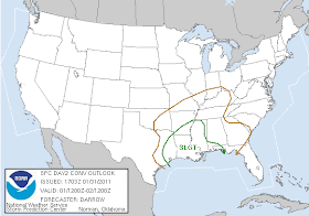
You can see that the low pressure responsible for the brutal weather to our north will pass very nearly over the metropolitan area. Heavy rain will surround the low, so I expect we'll see widespread rain totals of an inch of rain or more here. Thunderstorms will also be likely ahead of the cold front that will move through late tomorrow afternoon, though the greatest threat will be in the areas in the SLIGHT RISK region defined by the Storm Prediction Center in the map below.
 |
| Day 2 (Tuesday) Severe Weather Outlook from SPC |
Behind the front, look for a very rapid temperature change, thanks to strong Arctic high pressure building in behind the front. Temperatures could drop 20-25 degrees in a couple of hours, from the 60s head of the front to the 30s behind it. In fact, any lingering precipitation could change to flurries or a light snow shower after 9pm, though no accumulation is expected. By Wednesday morning, low temperatures will be in the mid 20s and Wednesday's high in the mid 30s will be nearly 30 degrees colder than Tuesday's high.
----
Stay up to date on the latest weather conditions and forecast by checking out MemphisWeather.net on Facebook and Twitter!


No comments:
Post a Comment