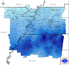
The Mid-South was blanketed by an early January snow storm during the evening hours on January 9th into the early morning of the 10th. Low pressure along the Gulf Coast provided the moisture while an upper-level low transiting north Mississippi brought the necessary lift that resulted in heavy snow and significant accumulations, especially near the track of the upper level low.
The entire region ended up under a Winter Storm Warning and, generally, final amounts were well forecast. As evidence, see MWN's post from Thursday morning indicating possibly enough snow to close schools and pretty much describing the scenario exactly as it unfolded, including timing. That afternoon, the NWS called for 2-5" across west TN and 5-8" south of I-40. A Friday morning update by MWN hit the timing and expected snow amounts over 48 hours in advance, while also predicting the afternoon issuance of a Winter Storm Watch. MWN's Saturday morning update was again on track, with a slight underestimation of actual snow amounts. The NWS issued a Winter Storm Warning Saturday afternoon, forecasting 3-6" for the metro area.
Below is a graphic produced by the National Weather Service in Memphis showing accumulations across the region, as well as a listing of individual reports received. Click here for the full graphic.

...SNOWFALL ACCUMULATIONS FROM JANUARY 9TH THROUGH 10TH...
COUNTY SNOWFALL (INCHES)
IN MISSOURI...
DUNKLIN........0.5
PEMISCOT.......1
IN ARKANSAS...
CLAY...........0.5
CRAIGHEAD......1-2
CRITTENDEN.....3-6
CROSS..........3
GREENE.........1 OR LESS
LAWRENCE.......1 OR LESS
LEE............4
MISSISSIPPI....1-3
PHILLIPS.......5
POINSETT.......2-3
RANDOLPH.......0.5
ST. FRANCIS....4
IN TENNESSEE...
CARROLL........1-2
CHESTER........3-4
CROCKETT.......1-2
DECATUR........3-6
DYER...........1
FAYETTE........5
GIBSON.........1
HARDEMAN.......4-8
HARDIN.........5-6
HAYWOOD........2
HENDERSON......3
HENRY..........1
LAKE...........1
LAUDERDALE.....2
MCNAIRY........5-8
MADISON........3
OBION..........1
SHELBY.........3-4
TIPTON.........4
WEAKLEY........1
IN MISSISSIPPI...
ALCORN.........7-10
BENTON.........9-10
CALHOUN........M
CHICKASAW......4-5
COAHOMA........7
DESOTO.........4-6
ITAWAMBA.......6
LAFAYETTE......7-8
LEE............6-10
MARSHALL.......5-7
MONROE.........4-6
PANOLA.........7-9
PONTOTOC.......8
PRENTISS.......8
QUITMAN........8
TALLAHATCHIE...5
TATE...........4-8
TIPPAH.........10
TISHOMINGO.....10
TUNICA.........5
UNION..........M
YALOBUSHA......3-5
----

No comments:
Post a Comment