One thing is for certain regarding the winter weather potential tomorrow versus the storm last week -- it won't compare in terms of snow amounts, duration, or degree of cold air behind the front. Until earlier today, the primary two computer models that provide detailed information beyond 24 hours have not agreed well. One (the NAM) has consistently been warmer ahead of the front and wetter behind the front, yielding snow amounts of 3" or more. The other (the GFS) has tempered the warm air ahead of the front reflected in lower high temperatures and has also been less aggressive with precipitation amounts, averaging about 3/4" of snow. Those differences, as hoped, narrowed today and as of mid-day are now very similar.
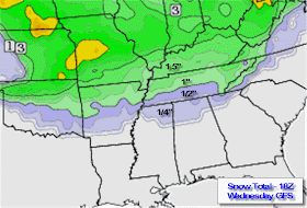
Here is the consensus and most plausible solution this evening: temperatures overnight will fall to near freezing then rise into the upper 30s to near 40 by noon. Light rain could begin by late morning. The cold front will slide through the metro area in the early afternoon and temperatures will begin to fall in the lowest several thousand feet of the atmosphere. As they do, precipitation may briefly change to sleet before becoming snow by about 3pm. Snow will continue for a few hours and taper off substantially after rush hour, ending by late evening. Snow amounts will average between 1/2" and 1" across the metro area with 1-2" not out of the question (see GFS model graphic solution below).
Temperatures will fall below freezing around rush hour and bottom out near 20 degrees Friday morning, only reaching the mid 30s on Friday under partly cloudy skies.


No comments:
Post a Comment