 |
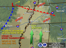
| Possible setup for severe thunderstorms on Thursday, courtesy NWS-Memphis |
The NAM and European models have a slightly faster solution and move the surface low across northeast Arkansas into western Kentucky during the evening - a track favorable for severe weather as the entire area would get into what is called the "warm sector" of the storm, where warm moist Gulf air can flow unabated into region. The GFS model takes the low a little farther south, almost directly over Memphis, and is slower by about 6 hours. It also is the wettest solution, though the severe weather threat would be lower due to the warm sector remaining to our south. The warm sector is the most favorable region for severe thunderstorms in most cases. At this time, the favored model solution is the NAM/Euro, which is depicted in the graphicast provided by the NWS above.
The one thing I do expect is a lot of rain, with the possibility of flash flooding. I would expect anywhere from 1-3" of rain depending on the ultimate placement of the fronts and low pressure track. Thunderstorms will first appear overnight Wednesday night (though these will likely be below severe limits with an outside chance of small hail) followed by a possible lull in the action during the morning hours Thursday. As the low and cold front approach, the "main event" will occur between Thursday mid-afternoon and midnight Thursday night.
Expect further blog updates as forecast confidence increases. Facebook and Twitter will be the best sources for real-time information during the event itself.
----
Stay up to date on the latest weather conditions and forecast by checking out MemphisWeather.net on Facebook and Twitter!

No comments:
Post a Comment