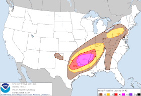
For the rest of the day and night, the metro counties remain under a MODERATE RISK of severe weather (see maps at bottom). Expect a few thunderstorms this evening once the atmosphere "re-energizes" following the mid-day storms. Some of these storms could be strong to severe. Then, the next major round of weather will likely be in the form of another squall line, though probably stronger and certainly cover a larger area than the mid-day storms. It too will be severe with the threat of large hail, damaging wind, and tornadoes. In addition, torrential rain will lead to some flash flooding. I expect a Tornado Watch to be issued by this evening, with the line moving through the metro area between 10pm and midnight (in fact, a Tornado Watch for central and northern AR is forthcoming as I type). Steady, perhaps heavy, rain will last for a few hours behind the line, or into the early morning hours. The timing of the line could be about the same time as the FedExForum will empty tonight, following a Grizzles victory over the Spurs.
Following tonight's line, it should be a little quieter through much of the morning and possibly early afternoon Tuesday before scattered supercell storms fire late Tuesday afternoon ahead of a developing surface low pressure system to our west. This low will have the greatest impact on our weather Tuesday night into early Wednesday, when the threat of severe storms will be maximized with the possibility of tornadoes, some of which could be long-lived and strong. This is still a developing situation and we'll have more on this threat during the day tomorrow.
The other threat that must be mentioned is that of flooding. The possibility of major flash flooding, urban flooding, and river flooding cannot be understated. By Wednesday afternoon, some places in the metro area may receive up to 8-12" of total rainfall. Creeks, streams, drainage ditches, low-lying areas, underpasses... all of these will become danger zones and could (hopefully not) take someone's life. Besides preparing for severe weather, also be prepared for the possibility of flooding. Some areas could see flooding that rivals May 1-2 last year! A complete set of safety tips for severe weather, tornadoes, and flooding, can be found at the bottom of the MWN Storm Center page and you can sign up to receive severe weather warnings by e-mail on our Severe Weather Notification page.
Below are the severe weather risk maps from the Storm Prediction Center:
 |
| Moderate Risk of severe storms over the metro area for tonight |
 |
| Hail threat for tonight, mainly southwest of the metro |
 |
| Tornado threat for tonight, indicating a risk of significant tornadoes (black hatched area) |
 |
| Damaging wind threat for tonight - nearly a 50/50% chance of severe wind |
 |
| Tuesday night convective outlook - significant severe weather is likely again overnight Tuesday |
Stay up to date on the latest weather conditions and forecast by checking out MemphisWeather.net on Facebook and Twitter and our new iPhone and Android apps!

No comments:
Post a Comment