Pages

Wednesday, November 30, 2011

Recap of a rare late-November Mid-South snow storm

It’s still November, but Mid-Southerners have already experienced the first snow event of the winter season! Thanks to a strong upper-level low pressure center which developed and moved through the region Monday night, the right combination of significant moisture and cold temperatures were able to make a rare early appearance. As a result, rain in the Mid-South began to change to snow and for some in the area it was enough for a decent accumulation! In general, it was the first measurable November snowfall in the region in two decades!

As is typical in Mid-South winter weather events, location made a great difference in just how much snowfall occurred. The strongest dynamics of the system, where the heaviest precipitation was able to develop, set up over a rather localized area and ended up largely north of the Memphis metro area. Complicating matters further, temperatures during the event were borderline, with readings generally remaining just above freezing, between 33 and 35 degrees. Additionally, ground temperatures remained well above freezing (in the 40s) due to the very warm temperatures preceding the system – it was 73 degrees in Memphis on Saturday! These factors served to limit snow accumulation potential greatly, but in areas where snow was able to fall hard enough, these limitations were overcome, allowing for accumulations in grassy areas and elevated and non-paved surfaces. Fortunately, roadways across the region remained just wet for the most part, resulting in few significant travel problems.

Across the city of Memphis, snow amounts were minor, a half inch or less. Memphis International Airport recorded just one-tenth of an inch of snowfall, with 0.3” recorded at the National Weather Service office at the Agricenter in East Memphis. Slightly higher amounts, up to 1”, occurred across northern Shelby County, with 0.6” recorded at MWN headquarters in Bartlett. Other areas of the metro, however, saw more significant snow accumulations. In Tipton and Fayette Counties, 1 to 2” of snowfall was a common occurrence, with localized higher amounts up to 2.5” in Fayette County. Amounts up to 1” also occurred across Crittenden, DeSoto and Tunica Counties.  

The most significant snowfall of this event though was north of the metro area. Several places in northwest Tennessee, the Missouri Bootheel, and especially northeast Arkansas saw snow accumulations of 2-4 inches as heavier snow bands redeveloped and persisted in these areas overnight Monday into early Tuesday morning. There were even isolated reports of up to 6”+ of snow accumulation, nearly hard to fathom for November in the Mid-South! See the map below for a more complete depiction of snow amounts across the entire region.

Map of snow accumulations reported across the region from Monday night – Tuesday morning. The heaviest amounts were to the north of the metro area. Map from the National Weather Service.
Once snow tapered off by Tuesday morning, whatever snow was left on the ground generally melted away very fast as temperatures recovered to near 40 degrees. However, to our north where the most significant snow occurred (and thus took longer to completely melt), visible satellite imagery was able to detect remnants of snow cover as late as Wednesday morning (see image below). Some of the most visible (and thus deepest) snow that remained was along the higher terrain of Crowley’s Ridge.

Remnant snow cover across northern portions of the Mid-South as detected by the GOES-East visible satellite on Wednesday morning. Cloud cover is noted to the east across Middle TN into Alabama.

It’s impossible to say whether this early start to the winter weather season in the Mid-South is a sign of things to come, but whatever lies ahead, you can count on MemphisWeather.Net to keep you accurately informed and up-to-date!

--Kevin Terry, MemphisWeather.Net

----
For weather information for Memphis and the Mid-South, where and when you need it, visit MemphisWeather.net on the web, m.memphisweather.net on your mobile phone, download our iPhone or Android apps, or visit us on Facebook or Twitter.

StormView Radar to be unavailable December 1-15 due to radar upgrade

Beginning Thursday morning, December 1, MemphisWeather.net's StormView Radar will be unavailable for two weeks.  It is expected to return to service on December 15.  Alternate radar links will be provided on the StormView Radar webpages, as well as on our mobile site (m.memphisweather.net).  On the MWN Android and iPhone apps, radar data will NOT be available during the outage due to programming constraints.

The reason for the outage is a significant upgrade to the National Weather Service (NWS) Doppler radar in Millington, TN.  The Millington radar (KNQA) provides the raw data to power StormView Radar. The upgrade, known as "dual polarization" (or dual-pol), was described in a previous blog post and represents the largest advancement in technology applied to the nationwide Doppler radar network since it's initial installment in the 1990s.  There are many benefits that meteorologists with access to the radar data (especially those who provide warning services to the public from the NWS) will reap.  Those are also described in the previous post linked above.

We apologize in advance for the inconvenience this will likely cause, though we ask you to understand that this is completely beyond our control and is a necessary and highly beneficial upgrade to the weather community.

To learn more about dual polarization, or to take online training designed for non-meteorologists on the changes, visit this MWN blog post or the NWS-Memphis dual-pol overview page.

----
For weather information for Memphis and the Mid-South, where and when you need it, visit MemphisWeather.net on the web, m.memphisweather.net on your mobile phone, download our iPhone or Android apps, or visit us on Facebook or Twitter.

Monday, November 28, 2011

Monday mid-day update on tonight's winter weather potential

Only a few changes since our post last evening with respect to the developing winter weather scenario that will play out in the next 24 hours across the Mid-South.

Newer model data has arrived and is continuing a similar solution to yesterday with the potential for a band of moderate snow to setup in the Mid-South.  Yesterday, we downplayed any significant accumulations due to climatology and recent warmth that could cause significant melting as the snow hits the surface, particularly paved surfaces.  While these factors have not changed, a case could be made that the strength of the now-formed upper level low pressure system (see graphic below) could produce some moderate snowfall, which could overcome (at least in the short term) surface melting.  (Surface temperatures on pavement are currently in the mid 40s in the metro.)  The result could be slushy streets wherever the heavier band(s) set up.  The biggest question is where the heavier band(s) will setup!

The upper level low pressure system responsible for our upcoming snow was over extreme western MS at mid-morning (red X in the graphic) and will be shifting to the northeast over the next 24 hours.

The forecast position of the upper low by 6am Tuesday, showing it moving into the Tennessee Valley Tuesday morning

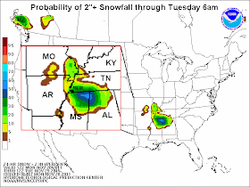
Morning model data has shifted just slightly where it thinks the heaviest snow may line up, from southern west TN into northeast MS yesterday to more squarely over west TN and even, to an extent, northeast AR.  We'll have to see how this development plays out.  Regardless, for the Memphis metropolitan area, we are still fairly confident in a light accumulation of snow (perhaps 1-2"), mainly on elevated and grassy surfaces overnight.  The graphic below is from the National Weather Service depicting the probability of a 2" snowfall by 6am Tuesday, which continues to indicate the highest chance east of the city, closer to the center of the low.


A Winter Weather Advisory covers most of the metro except for Fayette and Marshall Counties (and points east) where a Winter Storm Watch is in effect for tonight.  Expect the Winter Storm Watch to be upgraded to a Winter Storm Warning or a Winter Weather Advisory (depending on the expected snow amounts at that time) by the NWS around 4pm this afternoon.  A map of the counties affected as of late morning is below.


As for Tuesday morning rush hour impacts, it's hard to say what to expect at this time.  School systems will likely have to make a decision Tuesday morning.  I doubt many will decide before seeing what is actually on the roads.  Be prepared for possible hazardous conditions early Tuesday morning, mainly in outlying areas, and stay tuned to MWN on Facebook and Twitter (at the links below) for the latest information.

Finally, one other interesting question was posed: will the official recording station for Memphis (Memphis International Airport) receive snow before it gets it's first fall freeze?  It's looking more and more likely!  The lowest temperature so far this fall has been 33 degrees at the airport.

----
For weather information for Memphis and the Mid-South, where and when you need it, visit MemphisWeather.net on the web, m.memphisweather.net on your mobile phone, download our iPhone or Android apps, or visit us on Facebook or Twitter.

Sunday, November 27, 2011

Straight talk on our snow chances for the next 36 hours

The Mid-South is buzzing about the possibility of snow tonight and again Tuesday night.  Several have asked for my opinion, or what I think of "this forecast" and "that forecast."  So here it is!

DISCLAIMER: So everyone knows where I am coming from, this is the stance I am taking with regards to this event (and all potential "impact" events) - it's no hype, an educated forecast, straight talk, and my gut feelings, all wrapped into one.  I've seen 25 Mid-South winters, so my instincts are generally decent with regards to Mid-South weather patterns.  Also, the thoughts in this blog apply to the Memphis metropolitan area ONLY. Other excellent and well-educated folks cover other regions or larger regions; MWN specializes in the eight-county metro region.  With all due respect to The Weather Channel, I'm not interested in what they put on a national map, highlighting large areas and indicating a potential of 4" of snow.  That's not local forecasting - what we do is.

Back to the matter at hand... The meteorological discussion surrounding the chance of snow was discussed at length yesterday and still pretty much applies. I won't re-hash.

First, the "easier" of the two potential snow events, which is tonight. The good news is that most precipitation should be very light tonight and the chances of rain or whatever falls have decreased. I've posted them at 40% in the MWN Forecast.  We could see a few flakes mix in with light rain or drizzle in the wee hours of Monday morning.  It won't be enough to coat grass, streets, or anything else. Schools will be in session and roads will be fine (other than potentially wet).  It will stay cold and possibly wet throughout much of Monday.  Look for a high near 40 and intermittent rain showers, becoming steadier as the day goes on.

For Monday night: As the upper level low mentioned in my previous blog post (linked above) strengthens and moves from north MS/AL into middle TN Monday night, even colder air aloft will develop over the region and the Mid-South will be in a favorable position with respect to the low for precipitation formation.  Due to the cold air aloft, cooling surface temperatures into the 30s, and plenty of dynamics from the strengthening system, there appears to be a better chance of winter precipitation Monday night than tonight.  With more total precipitation expected, it makes sense that we could see more snow. Right?  Kind of.

The details continue to be sketchy, but the above logic seems to be panning out in the computer models.  Thus, the chances of snow in our forecast are higher Monday night than tonight. BUT (there is always a but), it will all depend on the position of the low and the degree of cold air.  I don't think we have to worry about whether there will be precip at this point.  I also don't think we have to worry about whether there will be enough cold air under the low. But the position of the low, potentially a couple hundred miles to our east, could mean that we miss out on the brunt of the cold air and we get more rain than snow. More rain than snow means virtually no accumulation.  The other factor against accumulation is the warm ground.  Face it - it's November, not January.  Snow just doesn't accumulate much in late November in the Mid-South because snow melts when it hits warm ground.  It has to snow pretty hard to overcome the rapid melting.

Having said all that, there is a CHANCE that some areas (I think those east of the Memphis metro in northeast MS and closer to the Tennessee River in west TN) could see minor accumulations by Tuesday morning (perhaps an inch or so on non-paved surfaces). I'm not holding out any hope, especially in the metro, of that happening.  But it could and I would be doing you a disservice to dismiss it. I haven't posted any maps of potential accumulation or favored areas here because, well, I haven't found one I like!

Another day of computer models and monitoring the ground temps will help a great deal.  More tomorrow... maybe with a map. :-)

Follow MWN on Facebook and Twitter for more regular updates.  Links can be found below.

Erik Proseus
Meteorologist, MemphisWeather.net

----
For weather information for Memphis and the Mid-South, where and when you need it, visit MemphisWeather.net on the web, m.memphisweather.net on your mobile phone, download our iPhone or Android apps, or visit us on Facebook or Twitter.
Saturday, November 26, 2011

Snow or no? Discussion on the possibility of Mid-South November snow

It seems much too early in the year to be discussing a real threat of snow in the forecast (as opposed to wish-casting a storm in the model output 2 weeks out).  But it appears Mother Nature wants us Mid-South meteorologists to fine-tune our winter forecast skills early this year as she is throwing a doozy at us! Not so much in the way of a big snowfall, but in the complexity of the factors that could come together to bring us our first flakes of the winter of 2011-2012!

We'll start with the "easier" part. A potent cold front stretching from southern Canadian into the Gulf of Mexico will move through the Mid-South overnight tonight, tapping an abundance of moisture that will produce widespread rainfall, mainly from evening through the overnight hours. In addition, a weak surface low will form in the Lower Mississippi Valley, which could provide enough lift for some scattered rumbles of thunder and periods of heavy rainfall. Rainfall amounts of up to 2"+ are not out of the question tonight.

Surface map valid at 6am Sunday showing a cold front near the Tennessee River and  low pressure over northeast MS

24-hour projected rainfall totals from HPC/NWS through 6am Sunday
As low pressure develops along the front, it will effectively stall out just to our east and low pressure will also form in the upper air pattern behind the front.  The complexity in the forecast deals with the strength, position, and movement of the upper low.  The forecast graphics below are from the generally-preferred model this morning, the European model (or ECMWF), showing the expected position of the low Monday morning and Tuesday morning.  The upper low is right over the Mid-South Monday morning and shifts east to the TN Valley Tuesday morning.

The European model shows upper level low pressure centered over the Mid-South on Monday morning
The European model shows the upper level low moving east into the TN Valley on Tuesday morning
The position of the low is not the only factor in a snow forecast, however.  Far from it!  The amount of available moisture, strength of the low, and degree of cold air throughout the atmosphere (from surface on up) all play a major role.  And in November, things have to be pretty much perfect to get accumulating snow south of the Mason-Dixon line!

Computer models don't necessarily know that though and can spit out some pretty incredible forecasts, such as the overnight run of the NAM from last night (shown below), which brings Memphis a couple of inches of snow on Sunday night!  The very next run of the same model (this morning) indicates less than 1" for the Memphis area and 8-10"+ for middle TN!  (I wouldn't bet on either one, by the way... fickle models!)  This is what we meteorologists get to deal with and why southern snow forecasts can be the hardest of them all!

Total snowfall forecast from the NAM midnight model run showing 4"+ over Memphis... not likely
For comparison, the Saturday morning NAM model run, which now shows <1" for Memphis and 8"+ for middle TN
We'll be watching the models closely over the next 48-72 hours, especially watching for more agreement among them, which would lead to a higher confidence forecast.  For the time being, the MWN Forecast carries a chance of a rain/snow mix late Sunday night/early Monday with another chance Monday night as the low pulls away.  Due to warm ground temperatures (it's over 70 degrees today), I would be surprised if more than a little sticks on grassy surfaces by Monday morning.  Given that there is a chance of snow, you can BET on cold temperatures!  We'll see the mercury fall through the 40s Sunday and perhaps remain in the 30s all day on Monday!

Further updates to the blog can be expected through the weekend.

----
For weather information for Memphis and the Mid-South, where and when you need it, visit MemphisWeather.net on the web, m.memphisweather.net on your mobile phone, download our Android app, or visit us on Facebook or Twitter.

Thursday, November 24, 2011

Happy Thanksgiving from MWN!


MemphisWeather.net and Cirrus Weather Solutions thanks you for your support, trust, and patronage throughout 2011!  Wishing you all a happy, healthy, and prosperous holiday season and 2012.


Tuesday, November 22, 2011

MWN 2011-2012 Winter Outlook

This is the 3rd year I have put together a winter outlook on the MWN Blog.  You could say I am "cheating" this year since it is coming out about a month later that the past 2 years.  Instead of calling me a cheater, consider yourself lucky - I almost didn't do one. But then I might let down a certain East Memphis dentist who has asked my opinion on the subject annually for at least a decade now... you know who you are.  To view my last two winter outlooks, click these links:  2009-2010  or  2010-2011

Climatological factors in the forecast
As many of you will remember, last year's winter pattern was driven by two factors, a strong La Nina and a strongly negative North Atlantic Oscillation (NAO-) (both link to Wikipedia).  Combined, they produced a hellacious winter in the Northern Plains and eastern U.S.  While the NAO is somewhat difficult to predict more than a couple of weeks in advance, scientists are fairly confident that we will experience a second straight La Nina winter after briefly emerging from La Nina conditions earlier in 2011.  (La Nina is a cooling of the waters of the equatorial Pacific.)  The consensus seems to be that it won't be as strong of a La Nina as last year, however.  The graphic below shows the general or typical conditions expected for North American winters during a La Nina pattern.  The jet stream pattern under average La Nina conditions blows across the southern U.S. from origins in the central Pacific (off the Mexican coast) as shown below.  However, at times, the polar jet stream will take large dips into the eastern U.S bringing a blast of cold air.

A typical La Nina pattern and resultant effects on North American winter
What others are saying
Based primarily on a weak to moderate La Nina episode this winter, NOAA, Accuweather, and others have put together their winter outlooks for 2011-2012.  In general, the effects are similar to last year only slightly tempered due to the weaker La Nina expected.

NOAA, the parent organization of the National Weather Service, predicts well above normal temperatures for the southern U.S. from the Desert Southwest to the Lower Mississippi River Valley, while cooler than normal conditions will be found on the west coast and colder than normal across the Northern Plains into the western Great Lakes. Precipitation-wise, the northern half of the country is expected to be wet, especially across the Pacific Northwest and Northern Rockies, as well as the Ohio Valley.  Drier than normal conditions are forecast across the southern tier of the U.S., particularly the Southern Plains (where an exceptional drought is ongoing) and the Gulf Coast into the southeast Atlantic coast.  Graphics below depict the NOAA forecast for December - February.

NOAA Temperature Outlook for Winter 2011-2012. Click for larger image.

NOAA Precipitation Outlook for Winter 2011-2012. Click for larger image.
Another winter forecast that some like to look to comes from private weather firm Accuweather.  It is similar to the NOAA outlook, highlighting cold and wet conditions across the north, wet weather in the northwest, and dry weather continuing across the south-central U.S.  The Accuweather outlook also includes the possibility of stormy conditions (including winter precipitation) over the Mid-South and Tennessee and Ohio Valleys, as well as up the east coast.

Accuweather Winter Outlook for 2011-2012. Click for larger image.
Finally, it's always interesting to look at what the Farmer's Almanac has to say. Their graphical outlook is below, which in their article is termed "Clime and Punishment."  It also indicates a mild and wet winter for the Mid-South.
Farmer's Almanac Winter Outlook for 2011-2012. Click for larger image.
MWN's Outlook
I'm the first to admit I am not a climatologist, nor a very good research scientist.  I'm better at the next couple of hours than the next couple of months.  So in long-range outlooks, I typically take the path of least resistance and that is what I will do this time. Last winter, La Nina produced several snow storms and late winter severe weather in February and March.  Temperatures were below average in December (in particular) and January and below normal precipitation throughout the winter, despite above average snowfall.

Given we are likely in for a tempered La Nina winter and the forecasts described above, I expect that precipitation and temperatures will be near normal over the course of the entire winter.  However, I also believe that we will see some extremes at times, with a chance of late winter severe weather once again and at least a couple of decent chances at snow or ice.  We'll see how it all works out!  One thing you can be assured of - just because it's warm one day doesn't mean it will the next!  In fact, it almost guarantees it won't!

Here's to a few snow storms and no ice this winter!

Erik Proseus, Meteorologist
Cirrus Weather Solutions/MemphisWeather.net

----
Visit MemphisWeather.net on the web, m.memphisweather.net on your mobile phone, and download our iPhone or Android apps. Nowcasting services provided on Facebook and Twitter.

Saturday, November 19, 2011

The latest on an extended wet weather pattern

Clouds have been on the increase this Saturday with moisture levels on the rise under breezy southerly wind. Moisture is increasing ahead a cold front moving southeast out of the Central Plains states, headed for the Mid-South. The front will approach the region Sunday, but like we saw with our previous cold front earlier in the week, it will not sweep through very quickly at all. In fact, the front will stall just north of our area, resulting in extended rain chances that will continue through late Tuesday, with periods of heavy rainfall and thunderstorms possible.

Though the regional radar is dry as of Saturday afternoon, expect that to be changing soon. Rain will begin breaking out ahead of the front after midnight across Arkansas and Missouri, slowly pushing southeast. This first round of rain will impact the metro during the day Sunday. At the same time, the front is expected to stall just north of the region. As this happens, repeated upper level disturbances will track along the stalled surface boundary, resulting in additional rounds of rain that will continue into Monday.  After a brief break late Monday into early Tuesday, a final and much stronger upper level disturbance will move in from the southwest, resulting in the development of surface low pressure that will move just north of the region, finally sweeping the cold front through by Tuesday evening. This will lead to the final round of rain for the metro area.

Though confidence is high that the front will stall somewhere just north of the area on Sunday, exactly where that happens remains uncertain, which will be key to what parts of the metro see the heaviest rainfall amounts during this period. At this time, the latest computer model guidance indicates the front’s stall will occur near the Arkansas/Missouri border. Should this happen, the steadiest and heaviest rain would be north of Interstate 40, while areas to the south may have more extended dry periods and thus lesser rainfall amounts, especially between Sunday and Monday when the front is stalled.  This would be quite similar to the situation earlier in the week with our previous system.

The most significant hazardous weather threat during this period will be heavy rainfall. In general, 1 to 4 inches of rainfall can be expected across the metro between Sunday and Tuesday. However, areas north of Interstate 40, closer to the stalled front, may see even higher amounts, with totals up to 6 inches possible.  In these areas, specifically across Crittenden and Tipton Counties (which also saw the heaviest rainfall earlier in the week), a threat of flash flooding may develop. Therefore, a Flash Flood Watch has been issued by the National Weather Service from Sunday night through Tuesday afternoon. Across the remainder of the metro, even though a widespread flooding threat is currently not anticipated, some issues with standing water may still develop, especially in flood-prone areas. No matter where you are, if you encounter a flooded roadway, as the National Weather Service says: Turn Around, Don’t Drown!

National Weather Service forecast precipitation between Sunday and Tuesday, indicating rain amounts of 1 to 3 inches in the metro. Higher amounts are possible north of Interstate 40.
In addition to the heavy rain and flooding potential, thunderstorms are possible as well during this period. The best threat for storms is expected to be with the final round of rain on Tuesday, with a band of thunderstorms likely to sweep through ahead of the cold front. As is typical during the fall season, the amount of expected instability is in question, but strong wind dynamics will be in place. Nevertheless, some strong thunderstorms may occur. A better assessment of this potential will be possible closer to Tuesday itself, as more computer model data will be available.
GFS model forecast for Tuesday morning (11/22), depicting a low pressure area to our NW, which will help sweep the cold front and a final band of rain and thunderstorms through the region.
Stay with MemphisWeather.Net for the very latest information on the heavy rain and thunderstorm threat as it evolves over the next few days. Our MWN Storm Center and forecast page will have full and updated details, with social media nowcasting on Facebook and Twitter expected as well.

--Kevin Terry, MemphisWeather.Net

----
For weather information for Memphis and the Mid-South, where and when you need it, visit MemphisWeather.net on the web, m.memphisweather.net on your mobile phone, download our Android app, or visit us on Facebook or Twitter.

Thursday, November 17, 2011

The cycle continues … another round of weather ups and downs ahead

It’s becoming a bit of a broken record by this point, but the cycle of ups and downs that have highlighted November’s weather thus far will not be letting up in the week ahead.  After our last bout of rain brought some impressive totals, and much needed as well, to the region – from 1 to as much as 3 inches – we’ve now settled back into a period of high pressure, dry conditions, and much cooler temperatures.  However, as with the last several weeks, the mild weather’s return is not far off in the distance, and neither are our next rain chances. In fact, it appears another extended period of wet weather is on the way to the region for next week.

First, the cool temperatures still have another day or two left to go, as readings have struggled to climb through the 50s today with a light northerly breeze and crystal clear, sunny skies aided by very low humidity levels.  These conditions will set up a cold night tonight, with another freeze expected for most of the metro area, including upper 20s outside the Memphis city limits. Southerly wind flow will set back in on Friday, marking the start of a gradual warmup, though readings will remain a bit below the mid-November average for one more day.

Breezy south winds Saturday will allow moisture levels to increase, leading for increased mid and high level cloudiness, with temperatures back well into the 60s. Meanwhile, a cold front will begin slowly pushing southeast out of the Central Plains states, and it will begin impacting Mid-South weather on Sunday.  Rain will break out along and ahead of the front, and push through the region Sunday and Sunday night. A few thunderstorms are possible as well, but with no severe weather expected.

Very similar to the situation earlier this week, it appears the front will then stall Sunday night just north of the metro area, across Northeast Arkansas into Northwest Tennessee, and will remain nearby the area through at least Tuesday. This will mean continued rain chances, with several rounds of showers and a few thunderstorms possible. On Tuesday, a stronger upper level disturbance will allow a low pressure area to develop and track through the region, finally sweeping the cold front through by early Wednesday. A final round of rain and thunderstorms is anticipated as this happens. Models are still not in agreement on the exact timing and track of this low pressure, which will ultimately determine if there is any threat of stronger thunderstorms with this final round of wet weather.  Regardless, between Sunday and Tuesday, total rainfall amounts of a few inches are certainly possible. With this week’s rainfall, this may allow for some ponding and standing water issues to develop in flood prone areas.

National Weather Service surface weather forecast for Monday shows the stalled front just north of the Memphis metro area, which will keep clouds and rain chances in the forecast through Tuesday.
Fortunately, this system looks to exit the area just in time for the Thanksgiving holiday, with a return to high pressure, drying conditions and cooler temperatures anticipated. Those traveling on Wednesday currently look to have no significant weather concerns to deal with, and Thanksgiving itself currently looks sunny and seasonably cool.

Early look at the GFS model forecast for Thanksgiving afternoon shows nice weather for the Mid-South and much of the country.
You’ll want to stay close to MemphisWeather.Net over the next several days as new details emerge on our rain and thunderstorm chances early next week, with the forecast fine-tuned. We’ll also keep you up-to-date on the Thanksgiving weekend forecast!

--Kevin Terry, MemphisWeather.Net

----
For weather information for Memphis and the Mid-South, where and when you need it, visit MemphisWeather.net on the web, m.memphisweather.net on your mobile phone, download our iPhone or Android apps, or visit us on Facebook or Twitter.

Wednesday, November 16, 2011

Altostratus Undulatus (wavy clouds!) visit the Mid-South

This afternoon as the weather system that has been plaguing the Mid-South for a couple of days was departing, atmospheric conditions came together to produce some stunning clouds.  After researching the conditions, the pictures received, and observing the clouds firsthand, I came to the conclusion that these were undulatus clouds, or more specifically Altostratus Undulatus.  You'll notice the word "undulating" in the name and that is exactly what they looked like.  As my 6-year-old astutely described them, they looked like the ocean, only up in the sky!  Below is a short video clip and a couple of pictures I took of the "wavy clouds" near Memphis International Airport this afternoon.


Pics and video above of the undulatus clouds as seen at Memphis International Airport. All  were taken by  MWN meteorologist Erik Proseus.
Being able to see undulatus clouds is fairly rare, even though the conditions that cause them are not. There are several factors that seem to come into play to produce visible undulatus.  The presence of abundant moisture at the right level in the atmosphere to create clouds in the first place is obviously important. Without moisture, there are no clouds and any atmospheric waves slip by unnoticed. Second, a trigger for the rising air is needed - in this case a weak upper level disturbance or set of gravity waves moving by could very well have been that trigger. Finally, to get the wave motion, the rising air needs to be forced back down and the cycle repeated (upward motion, then downward motion of the air). This is accomplished with a "stable layer" in the atmosphere.

Think of it in this manner - if a pond is undisturbed by wind, animals, bugs, or any other external force, it is perfectly flat (stable). Drop a pebble in the pond and ripples move out from the point where the pebble was dropped in. The water rises and falls creating miniature waves.  It doesn't keep rising; it doesn't keep falling. The waves move out from the center and try to regain equilibrium, or stability, which is the flat and still pond. In the atmosphere, rising air reaches a stable point, gets forced back down once it rises above that stable point, then starts rising again, over and over as it attempts to regain equilibrium.

The atmospheric cross-section (or profile) from 3pm this afternoon is shown below.  The red line is temperature, the green line is dewpoint (or moisture), the ground is at the bottom of the picture, and as you go up in the image, you are going up into the atmosphere. Wind is shown on the far right.  This cross-section shows a stable layer (or inversion base) at about 3,000'.  It also happens to be where the red and green line meet, representing 100% humidity and the presence of clouds.  In today's case, the upper level disturbance or gravity waves moving through triggered rising air, which got to about 3,000 feet, reached the stable layer, and then rose and fell around that inversion base or stable layer - thus "ripples" or waves in the atmosphere. We wouldn't have "seen" those ripples except that that level was also where the moisture existed (the clouds).  The stable layer separates wind above it that was blowing from the west and wind below it that was blowing from the north to northeast.

Atmospheric sounding from the NAM forecast model for 3pm CST. Details described in text above.
Here's one more interesting piece of evidence regarding the waves.  Check out the radar loop below during the same time frame.  There are a series of bands of light rain moving from west to east and oriented northeast to southwest. This could very well be the "triggering mechanism," i.e., the upper-level trough or gravity waves, reflected in some bands of light precipitation near the surface.  A very interesting weather phenomena today no doubt!


If you snapped any pics or video of the clouds, feel free to send them to our Twitter account (@memphisweather1), put them on our Facebook wall (link below), or send them to photos MemphisWeather net.

----
For weather information for Memphis and the Mid-South, where and when you need it, visit MemphisWeather.net on the web, m.memphisweather.net on your mobile phone, download our iPhone or Android apps, or visit us on Facebook or Twitter.

Sunday, November 13, 2011

Another week, another high chance of rain and thunder in the forecast

If there’s one word to describe this weekend’s weather, it’s undoubtedly windy! Just days after experiencing our first widespread freeze of the fall, southerly winds have made their return to the Mid-South and in a very strong fashion. Winds have frequently been sustained between 20 and 30 mph, with gusts near 40 mph, and a few gusts even over 40 mph on Sunday. The weekend has also brought back the mild temperatures, with readings reaching the 70s, along with a high overcast as moisture levels begin increasing ahead of our next system.  This system will be moving into the region late Monday into Tuesday, bringing more rain and possibly a few thunderstorms.

The high overcast, windy conditions and mild temperatures will continue through Monday before the arrival of rain, with highs approaching the upper 70s, and wind gusts to near 30 mph possible. Meanwhile, showers and a few thunderstorms will begin developing to our northwest by Monday afternoon, slowly pushing southeast along a cold front.  This rain will move through the Memphis metro area Monday night, but as it pushes through, the cold front will stall near or just north of the region.

National Weather Service surface weather map forecast for Monday evening, showing the cold front to our northwest that will eventually stall in the area by Tuesday morning.
With the front’s stall, widespread rain and isolated thunderstorms will continue developing in the front’s vicinity Tuesday. After a brief break in rainfall is possible early in the day, rain will be moving back in by the evening, and may continue into much of Tuesday night, making for a wet 18 to 24 hour period. Between Monday and Tuesday night, total rainfall amounts of 1 to 2 inches will be possible. Severe thunderstorms are not expected at this time as instability levels, like in previous systems, will be limited.

NAM model forecast for Midnight Tuesday night showing widespread rainfall over the region occurring along the stalled cold front.
The front will finally be able to push through and out of the region by Wednesday morning, leading to drying conditions along with a cooler airmass dominated by high pressure. High temperatures will return back to the 50s to near 60 to close out the workweek, with lows in the 30s and 40s. Southerly flow looks to be back in the picture for next weekend, along with the milder temperatures and increasing clouds, with our next system and associated rain chances likely to start off the following workweek.

--Kevin Terry, MemphisWeather.Net

----
For weather information for Memphis and the Mid-South, where and when you need it, visit MemphisWeather.net on the web, m.memphisweather.net on your mobile phone, download our iPhone or Android apps, or visit us on Facebook or Twitter.

Saturday, November 12, 2011

A primer on dual polarization radar – coming soon to the Mid-South!

You’re probably well aware of the use of “Doppler” radar technology in the Mid-South, and across the country, to detect and track areas of precipitation - whether rain, snow, or severe thunderstorms. This technology has been in widespread use since the 1990s and has helped to vastly improve the forecast and warning process for all types of weather phenomena. Now, nearly 20 years later, the National Weather Service is undertaking the most comprehensive and significant upgrade to its Doppler radar network since its inception. This upgrade, known as dual polarization (or polarimetric radar), will provide new and more accurate information to meteorologists about various precipitation areas detected by radar, allowing for even further improvements in the forecast and warning process.

So what exactly is dual-polarization and how does it differ from the conventional Doppler radar that we’ve used for years now? All weather radars, including Doppler, send out pulses of energy into the atmosphere in order to detect precipitation. When a pulse of energy hits a raindrop or a snowflake, for example, some of that energy is “reflected” back to the radar, which can then be mapped through computer software for display to meteorologists and general public. If you've seen or heard the term “radar reflectivity” before on TV or the internet, this is where that comes from! The radar is simply measuring the amount of reflected energy it’s received back. The more reflected energy that’s received back, in general, the heavier the  precipitation that is being detected. This is how we can differentiate between areas of lighter and heavier precipitation.

Up until recently, weather radars have sent out these pulses of energy oriented in only one direction - horizontally (see animation below). While this is sufficient for the general detection and overall intensity of precipitation, characteristics of the precipitation droplets, such as their size, shape, dimensions, and composition, can not be determined using only radar pulses oriented horizontally. In meteorology, knowing these details can be crucial in identifying whether precipitation is in the form of rain, snow, or even hail.

Conventional Doppler radar transmits and receives pulses of energy in a horizontally-oriented direction. This provides good detail on where precipitation areas are and how heavy they might be, but with little other information available. Image courtesy National Weather Service.
That is where the new technology comes into play. With dual polarization employed, the radar will now send and receive back pulses of energy oriented both horizontally and vertically (see animation below). With the vertical pulse added, we now are sent back some of those crucial details about precipitation returns that can help better identify some of their specific characteristics.

With dual polarization technology, the radar now transmits and receives pulses of energy in both a horizontal and vertical orientation. New details about precipitation returns are available, that can more accurately identify precipitation types and other characteristics. Image courtesy National Weather Service.
Among the benefits dual polarization may provide, based on National Weather Service research:
  • Better estimation of overall precipitation amounts
  • Improved detection of areas of heavy rainfall and flooding potential, improving the warning process
  • Improved detection and mitigation of non-weather echoes (removal of false returns such as ground clutter from the radar display)
  • Ability to classify possible precipitation types (which will improve even more with the subsequent software updates following the initial deployment of dual polarization)
  • New severe thunderstorm signatures, including better detection of hail and even tornado debris, aiding in the warning process
These potential benefits will be found through the addition of 14 new radar products that will become available once dual polarization is activated at each radar site. Even more benefits currently unknown may be found as the technology is deployed and used operationally across the country. However, with that said, it should be noted that there will remain limitations and drawbacks. Radar remains just one tool of a vast array of information available to meteorologists, and none will ever be more valuable than actual reports and observations by the “eyes and ears” at the surface - NWS severe storm spotters and the general public!

One of 14 new radar products available with dual polarization: Differential Reflectivity (DR). DR compares the intensity of energy reflected back in the horizontal pulse vs. the vertical pulse, which helps determine the shape and size of a precipitation return. In this example, cooler colors (blues/greens) are areas of snowfall; warmer colors (yellows/reds) are areas of ground clutter and other non-weather related returns
The National Weather Service is in the early stages of its transition to dual polarization technology, with its entire network of radars not expected to be completely upgraded until 2013. We are fortunate here in the Memphis area however, as we will become one of the first locations in the nation to receive the upgrade! The NWS Doppler radar in Millington, TN will receive dual polarization during the month of December. The upgrade consists not of replacing the entire radar itself, but rather replacing hardware within the already existing radar. Because of that, the radar must be taken offline during the installation process. The process takes about two weeks and is scheduled to be unavailable from December 1st-15th.

During this time, data from the NWS radar in Millington, which also powers MemphisWeather.Net’s StormView Radar, will not be available. Surrounding regional radars should remain online to help monitor the weather conditions in the Memphis metro and Mid-South area, and MWN provides links to those surrounding radar sites in the “Radar/Satellite” menu on our website. We will also provide links as needed on our Facebook and Twitter feeds during the upgrade.

If you want more information on the impending radar upgrade to dual polarization and other general information about it, visit the links below.
--Kevin Terry, MemphisWeather.net

----
For weather information for Memphis and the Mid-South, where and when you need it, visit MemphisWeather.net on the web, m.memphisweather.net on your mobile phone, download our iPhone or Android apps, or visit us on Facebook or Twitter.

Tuesday, November 8, 2011

National Emergency Alert Test on November 9, 2011

On Wednesday, November 9, at 1:00 PM CST, a first-of-its-kind nationwide test will be conducted in order to fully test the Emergency Alert System. The following statement comes from FEMA:

As part of our ongoing efforts to keep our country and communities safe during emergencies, we’re working in partnership with the Federal Communications Commission (FCC) and the National Oceanic and Atmospheric Administration (NOAA) to conduct the first nationwide test of the Emergency Alert System (EAS). The EAS test plays a key role in ensuring the nation is prepared for any type of hazard, and that the U.S. public can receive critical and vital information should it ever be needed.

Here are specific items we want everyone to know about the test:
  • It will be conducted Wednesday, November 9 at 1:00 PM CST. 
  • It will be transmitted via television and radio stations within the U.S., including Alaska, Hawaii, the territories of Puerto Rico, the U.S. Virgin Islands, and American Samoa. 
  • Similar to local emergency alert system tests, an audio message will interrupt television and radio programming indicating: “This is a test.” 
  • When the test is over, regular programming will resume. 
MemphisWeather.net intends to also use this opportunity to test our StormWatch alert services. This will involve sending a test Tornado Warning for all counties in the MWN coverage area, including Crittenden in east AR; Shelby, Tipton, and Fayette in west TN; and DeSoto, Tunica, Marshall, and Tate in north MS. MWN testing will be conducted between 2:00-3:00 PM CST. Those subscribed to StormWatch e-mail alert lists or who are following StormWatch Twitter feeds will receive the test Tornado Warning. No action is needed on your part.

For more information on the national EAS test, please see these FEMA FAQ's.

Monday, November 7, 2011

Secondary severe weather season returns to the Mid-South

While most Mid-Southerners are fully aware of the possibility of severe weather from mid-March through early June, there is also a distinct "secondary severe weather season" in the Mid-South that runs from November into early December.  The autumn transition season brings an increased number of frontal systems and diverse airmasses battling for control of the sky.  With cold air beginning to dive south out of Canada, strong Pacific fronts moving across the country, and Gulf moisture still exerting it's influence on the region due to southerly wind between frontal systems, the stage can be set for violent weather this time of year. Those who have lived in the region a number of years will recall the Thanksgiving weekend tornado that devastated a portion of Germantown in 1994 and be reminded that spring is not the only time we receive severe weather.

Now is a good time to review severe weather safety tips. The MWN Storm Center contains tips for severe thunderstorms, tornadoes, and flooding. Be sure that your NOAA Weather Radio (you do have one right?)  is programmed and has fresh batteries in case of a power outage. Share your severe weather plans with your family, especially any minors living at home, so that everyone is on the same page if severe weather does strike.

In addition, be sure to take advantage of a variety of ways MemphisWeather.net helps you stay informed before and during severe weather. MWN's array of "StormWatch" services include notifications of severe weather watchs and warnings by e-mail and Twitter, nowcasting during severe weather via Facebook and Twitter, and - coming very soon - StormWatch+!  While our e-mail and Twitter severe weather feeds will alert you if any part of your county is warned, StormWatch+ takes the process one step further, using the latest technology to alert you only in the event that your specific location is in the warned area, as defined by the National Weather Service.  StormWatch+ is coming to the MemphisWeather.net app for Android and iPhone in the coming days. (Android release is expected on November 14; iPhone release is pending Apple approval.)

For more details and information, or to sign up for StormWatch warning notifications, visit www.MemphisWeather.net/stormwatch.  You may also wish to follow @mwnstormwatch on Twitter for updates as they become available.

Finally, if you are interested in underground storm shelters, MWN endorses Take Cover Storm Shelters (read our endorsement review here).  Take Cover will provide you that extra peace of mind you may need during severe weather.  Give Jessica or Jon a call and tell them I sent you!
----
For weather information for Memphis and the Mid-South, where and when you need it, visit MemphisWeather.net on the web, m.memphisweather.net on your mobile phone, download our iPhone or Android apps, or visit us on Facebook or Twitter.

Space invaders: details on Earth's upcoming close encounter with an asteroid

During the early evening on Tuesday, November 8 (tomorrow if you are reading this on Monday), an asteroid called 2005 YU55 will make a close encounter with Earth.  Now don't worry - NASA has assured us that we are not in harm's way and no species will be extinct Wednesday morning from a collision!  However, it is the first time that an asteroid this large will make a close approach with prior knowledge of it doing so, allowing astronomers a chance to gather valuable data on 20005 YU55 as it zips by.  Here are some factoids:

Name: 2005 YU55
Size: 400 meters (about the size of an aircraft carrier)
Closest approach to Earth: 201,700 miles at 5:28pm CST Tuesday
Distance to the moon from Earth: 252,386 miles (on November 8)
Last Earth approach of an asteroid this large: 1976 (not known until 2000 though)
Next Earth approach of an asteroid this large: 2028

Will Mid-Southerners be able to see it?  Not likely - for two reasons. First, NASA indicates that a mid-size telescope (or better) will be required for backyard astronomers to view it.  Not many of us have that type of instrumentation. Second, if you did, unfortunately the weather will likely not cooperate. A storm system arriving Tuesday night will be throwing a large amount of cloud cover over the Mid-South throughout the day Tuesday. Even with the proper telescope and the knowledge to use it, clouds will likely obscure the phenomena. We'll have to resort to seeing other's reports of it on the news!  Below is an animated image of the path of 2005 YU55 relative to the path of Earth and the moon, courtesy of NASA.


For even more information from NASA on 2005 YU55, watch the two-minute video embedded below.

Information above courtesy SpaceWeather.com and NASA.  Visit these sites for additional info.

----
For weather information for Memphis and the Mid-South, where and when you need it, visit MemphisWeather.net on the web, m.memphisweather.net on your mobile phone, download our iPhone or Android apps, or visit us on Facebook or Twitter.

Sunday, November 6, 2011

Week ahead features high chance of rain and thunderstorms Tuesday night

As is typical for fall, the last few weeks have featured their share of “ups and downs” in weather conditions over the Mid-South region, as several cold fronts have brought rain, followed by cooler weather, then the return of mild conditions ahead of the next front. This week promises another cycle of the same, with our next cold front expected to move in on Tuesday night bringing with it more rain, but also a good chance of thunderstorms.

Ahead of Tuesday’s system, mid and high level cloudiness began increasing today over the region, which will be here to stay until the front clears the area. Still, temperatures will manage to warm into the lower 70s on Monday, and mid 70s on Tuesday as southerly wind flow increases. Meanwhile, the front will be making its approach from the west, sparking off areas of rain and thunderstorms.

By Tuesday afternoon and evening, rain and thunderstorms will begin organizing over Arkansas and Missouri ahead of the front, then spreading east. This activity will move into the Memphis metro during the course of Tuesday night into early Wednesday morning.  The heaviest activity will likely become focused within a squall line. While strong wind energy throughout the atmosphere will allow storms to become organized, instability is expected to be limited overall. Nevertheless, a few strong to severe storms are not out of the question as the squall line moves through the area, with the main threat being strong to potentially damaging wind gusts.

A large-scale trough and cold front will move through the region Tuesday night, bringing a chance of severe weather
The Storm Prediction Center in Norman, OK has the Memphis metro area on the eastern fringe of a slight risk area for Tuesday night (see below) with most severe weather expected to occur west of the Memphis metro area early Tuesday evening across central Arkansas. We will be closely monitoring the situation and bring you updates on the thunderstorm potential as it evolves over the next few days.  Total rainfall amounts of 1/2 to 1 inch, with locally higher amounts, are also possible.  Visit the MWN Storm Center and MWN Forecast for full details.
SPC places AR and the western portions of the Memphis metro in a slight risk of severe storms Tuesday 
The cold front should be pushing east of the area Wednesday morning, with clouds and perhaps light rain lingering into the day. The front’s passage means another round of cooler weather, as highs return to the 50s to near 60 through Veteran’s Day (Friday) under renewed high pressure. Conditions will be dry and mostly sunny. The entire area should see lows dip into the 30s Thursday night with another round of frost possible. As high pressure moves east, the southerly winds come back for next weekend, bringing with it the milder temperatures before our potential next front and associated rain chances come into play by early next week.

--Kevin Terry, MemphisWeather.Net

----
For weather information for Memphis and the Mid-South, where and when you need it, visit MemphisWeather.net on the web, m.memphisweather.net on your mobile phone, download our iPhone or Android apps, or visit us on Facebook or Twitter.

Thursday, November 3, 2011

October 2011 Climate Data and Forecast Accuracy

September saw a significant cooldown from the record heat of the summer of 2011 and October continued the trend, once again averaging below normal temperature-wise for the month. It was also a very dry month as the airport recorded only 32% of a typical October rainfall. No daily temperature or precipitation records were set during the month.

Memphis International Airport, Memphis, TN

The average temperature for the month of October was 62.7 degrees, which was 1.4 degrees below normal. The average high temperature was a comfortable 74.6 degrees and the average low was 50.8. The coolest temperature of the month was 36 degrees on the 29th, while the highest temperature was 86 degrees set on the 6th, 16th, and 17th.

Precipitation for the month totaled 1.28", which was 2.70" below average.  There were just 6 days with measurable rainfall and only 3 days with more than 0.10". The greatest 24-hour total was 0.50" on the 27-28th. The peak wind gust was 39 mph on the 16th with an average wind speed for the month of 6.4 mph. Click here for a daily statistical recap for Memphis International Airport.

Cirrus Weather Solutions, Bartlett, TN

The average October temperature at Cirrus Weather Solutions in north Bartlett was 58.7 degrees with a maximum of 86.1 degrees on the 17th and a minimum of 29.7 degrees on the 29th.  October precipitation was slightly less than the Memphis airport, totaling just 1.05", which was the driest month at Cirrus Weather Solutions since September 2010. A co-located manual gauge used for the CoCoRaHS program measured 0.98". The peak wind gust was 22 mph on the 26th. Average relative humidity was 69%. Click here for a daily recap on MemphisWeather.net.

MWN Forecast Accuracy

For the month of October, the average temperature error in all MWN temperature forecasts was 1.86 degrees, lower than all compared computer models, including the NWS. Nearly 77% of the MWN temperature forecasts for the month were within 2 degrees of the actual temperature. MWN's forecasts extend out five periods (or 2.5 days). For dewpoint accuracy, the MWN forecast beat all data sources, averaging 1.95 degrees error and falling within 2 degrees of the actual dewpoint almost 74% of the time. Historical accuracy statistics can be found here.

----
For weather information for Memphis and the Mid-South, where and when you need it, visit MemphisWeather.net on the web, m.memphisweather.net on your mobile phone, download our iPhone or Android apps, or visit us on Facebook or Twitter.