Newer model data has arrived and is continuing a similar solution to yesterday with the potential for a band of moderate snow to setup in the Mid-South. Yesterday, we downplayed any significant accumulations due to climatology and recent warmth that could cause significant melting as the snow hits the surface, particularly paved surfaces. While these factors have not changed, a case could be made that the strength of the now-formed upper level low pressure system (see graphic below) could produce some moderate snowfall, which could overcome (at least in the short term) surface melting. (Surface temperatures on pavement are currently in the mid 40s in the metro.) The result could be slushy streets wherever the heavier band(s) set up. The biggest question is where the heavier band(s) will setup!
 |
| The upper level low pressure system responsible for our upcoming snow was over extreme western MS at mid-morning (red X in the graphic) and will be shifting to the northeast over the next 24 hours. |
 |
| The forecast position of the upper low by 6am Tuesday, showing it moving into the Tennessee Valley Tuesday morning |
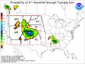
Morning model data has shifted just slightly where it thinks the heaviest snow may line up, from southern west TN into northeast MS yesterday to more squarely over west TN and even, to an extent, northeast AR. We'll have to see how this development plays out. Regardless, for the Memphis metropolitan area, we are still fairly confident in a light accumulation of snow (perhaps 1-2"), mainly on elevated and grassy surfaces overnight. The graphic below is from the National Weather Service depicting the probability of a 2" snowfall by 6am Tuesday, which continues to indicate the highest chance east of the city, closer to the center of the low.
A Winter Weather Advisory covers most of the metro except for Fayette and Marshall Counties (and points east) where a Winter Storm Watch is in effect for tonight. Expect the Winter Storm Watch to be upgraded to a Winter Storm Warning or a Winter Weather Advisory (depending on the expected snow amounts at that time) by the NWS around 4pm this afternoon. A map of the counties affected as of late morning is below.
As for Tuesday morning rush hour impacts, it's hard to say what to expect at this time. School systems will likely have to make a decision Tuesday morning. I doubt many will decide before seeing what is actually on the roads. Be prepared for possible hazardous conditions early Tuesday morning, mainly in outlying areas, and stay tuned to MWN on Facebook and Twitter (at the links below) for the latest information.
Finally, one other interesting question was posed: will the official recording station for Memphis (Memphis International Airport) receive snow before it gets it's first fall freeze? It's looking more and more likely! The lowest temperature so far this fall has been 33 degrees at the airport.
----
For weather information for Memphis and the Mid-South, where and when you need it, visit MemphisWeather.net on the web, m.memphisweather.net on your mobile phone, download our iPhone or Android apps, or visit us on Facebook or Twitter.


No comments:
Post a Comment