 |
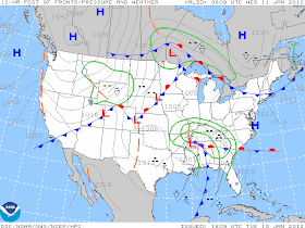
| Low pressure will track over the Memphis metro overnight bringing a potential round of severe weather |
 |
| The SPC convective outlook for today indicates a Slight Risk for severe weather |
Though the threat of severe weather in the greater Memphis area is low, remain aware of changing weather conditions and stay with MemphisWeather.net for the latest forecasts and severe weather information. As thunderstorms approach and cross through the area, we'll be nowcasting the event on our Facebook and Twitter streams (linked below) to keep you abreast of the situation. We also encourage you to check out our MWN Android app, which now includes the option of adding StormWatch+ - our personalized severe weather alert service that delivers watches and warnings directly to your Android device as they occur.
Behind this system, a strong Arctic cold front will move through the area Wednesday night, which will bring the first blast of winter to the area since the New Year. High temperatures will occur early Thursday with temperatures falling through the 30s on a gusty northwest wind during the day. For the complete forecast, visit MWN.
----
For weather information for Memphis and the Mid-South, where and when you need it, visit MemphisWeather.net on the web, m.memphisweather.net on your mobile phone, download our Android app, and visit us on Facebook and Twitter.

No comments:
Post a Comment