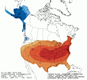
Ahead of this week's cold front, a very nice push of warm moist air originating in the Gulf of Mexico will move over the Mid-South. The air will arrive on gusty south wind, which will begin overnight tonight and last until the cold front arrives on Tuesday. Gusts could reach 30 mph or more on Monday and Monday night and a Wind Advisory may become necessary. The moist air will also mean mainly cloudy conditions and a chance of showers on Monday, but that will be offset by high temperatures in the mid 60s for MLK Day!
 |
| MWN surface map for Monday afternoon. Strong south wind escorts warm temps into the Mid-South ahead of a cold front over the Plains. |
The cold front will move through the region around mid-day on Tuesday and we'll see another "upside down" day as high temperatures in the lower to mid 60s occur in the morning, followed by temperatures falling into the 40s by late afternoon. Rain and t'storm chances will be confined to the pre-frontal atmosphere, which will be mainly in the morning. Behind the front, the wind will remain strong, but shift to the northwest versus the south. Skies clear Tuesday night with lows in the upper 20s and wind chills in the teens. The Wednesday morning "feels like" temperature could be some 40 degrees colder than Tuesday morning!
 |
| MWN surface map for Tuesday morning. A strong cold front nears the Memphis area with very cold temps in it's wake. |
For the complete forecast click here, and stick with MWN as we keep you updated on the rain and thunder chances, as well as our roller coaster temps this week.
What do you prefer - a warm January with highs in the 50s and 60s or cold, occasionally snowy, weather?
----
For weather information for Memphis and the Mid-South, where and when you need it, visit MemphisWeather.net on the web, m.memphisweather.net on your mobile phone, download our Android app, and visit us on Facebook or Twitter.


No comments:
Post a Comment