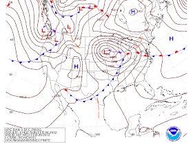
As we first posted yesterday,
MWN is closely monitoring the weather for Tuesday night as thunderstorms, including a threat for severe weather, may develop near or over
the Mid-South region. Since yesterday’s initial post, the timing of this system has changed a bit on the computer models, and
that has made some impact on the threat for the metro area.
 |
| NWS forecast for Wednesday AM, with advertised cold front now likely to pass through around mid-morning. |
 |
| The Storm Prediction Center's "Slight Risk" area has shifted west with this morning's update. |
Despite the focus shifting west, the threat
for severe weather in the metro has not been completely eliminated. With
thunderstorms still likely to impact the area overnight Tuesday into Wednesday
morning, and sufficient wind dynamics in place, some storms may remain strong as
they move through the area with wind gusts the most likely hazard. The largest
limiting factor to more widespread severe weather locally, partly due to the
system’s later timing, will be instability.
With this event still more than 48 hours out, further adjustments are possible. If more sufficient
instability levels appear in later models, or if the timing continues to
change, our threat of severe weather may increase again. MWN is continuing to
closely monitor this situation and will keep you updated via the methods at the
bottom of the post.
As also indicated
yesterday, now is a great time to make sure you are prepared for severe weather
this spring. Review the blog posts from earlier this week on various severe weather types and what to do in case severe weather strikes. We also HIGHLY encourage you to have multiple methods of receiving notification of severe weather threats, especially overnight. NOAA Weather Radio is one; outdoor warning sirens may NOT wake you up and are not intended to. The other is StormWatch+ - now available in the MemphisWeather.net smartphone apps for Android and iPhone. This mobile alerting technology will send you an audio alert (that will wake you up if your phone is not silenced and it's close by) and push notification if your location is under a watch or warning. It's personalized weather alerting in the palm of your hand! Learn more and download the app at StormWatchPlus.com.
--Kevin Terry, MemphisWeather.Net
----
For weather information for Memphis and the Mid-South, where and when you need it, visit MemphisWeather.net on the web, m.memphisweather.net on your mobile phone, download our iPhone or Android apps, or visit us on Facebook or Twitter.

No comments:
Post a Comment