Wednesday, 8:15pm update:
It appears computer models are holding off on any early morning precipitation for the Mid-South. Given the information provided in the blog post immediately below, our confidence is increasing we will see some severe thunderstorms in and around the area beginning anytime after late morning. The most likely time will be during the afternoon and early evening hours. Though a tornado threat can't be completely ruled out, the primary threats with tomorrow's storms will be large hail and high wind. Storms should form into clusters or lines, which could heighten the straight-line wind threat.
MWN will provide nowcasting via social media throughout the event tomorrow. Now is a good time to arm yourself for the potential of severe weather with the MemphisWeather.net app with StormWatch+. StormWatch+ is our personalized severe weather notification tool that will warn the locations you input when severe weather threatens. Check it out now on iTunes/App Store or Google Play for Android.
Previous blog entry:
 |
| The Mid-South is under a Slight Risk of severe weather for Thursday. How the scenario plays out is the subject of this blog. |
 |
| Multiple mesoscale convective systems (MCSs) traverse the Plains and Midwest (June 27, 2011) |
 |
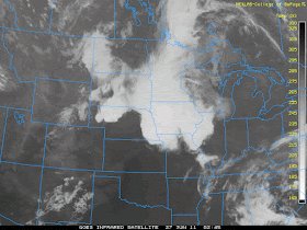
| Satellite imagery at time of above radar image. Extensive cloud cover accompanies MCSs. After the MCS falls apart, the lingering cloud cover can hinder further convection later in the day. |
So, will the overnight storms die off over AR, leaving us with an unaffected "juicy" airmass capable of generating afternoon/evening severe thunderstorms? Or do we get the "fallout zone" - with morning clouds/showers and afternoon storms that fire off to our east? Time will tell... Either way, I think this will be our best chance for meaningful rain in some time.
----
For weather information for Memphis and the Mid-South, where and when you need it, visit MemphisWeather.net on the web, m.memphisweather.net on your mobile phone, download our iPhone or Android apps, or visit us on Facebook or Twitter.

No comments:
Post a Comment