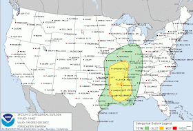
The low pressure system responsible for the significant storm will be over northern OK early Wednesday evening. Ahead of the low, wind at the surface and well overhead will increase and showers and thunderstorms will break out across eastern OK and TX into western AR and LA. The wind energy associated with this system will be the main ingredient that forces the development of a line of thunderstorms during the evening hours well to our west.
As the low moves towards central MO during the evening, storms will break out along and ahead of the cold front and organize into a broken line that will stretch across central AR and down I-30 into northeast TX by about midnight. We expect this line to solidify and move through the metro in the early morning hours Thursday, or likely between 3-6am.
As for impacts, the main threat with the line will be strong to damaging thunderstorm wind gusts of up to 55-70 mph along the squall line. With that much wind in place, both at the surface and above the region, an isolated tornado also cannot be ruled out, but the threat is minimal and seems to be focused over central AR. However, the vast majority of the wind energy will be of the straight-line variety.
 |
| Storm Prediction Center severe weather outlook for Wednesday night. Click for larger image. |
 |
| Behind the cold front, temps will fall into the 40s Thursday and wind will gust to 30-40 mph. Click for larger image |
In the longer term (Christmas time), models are hinting at another strong system for the middle of next week. While there is plenty of time to determine exact impacts to the Mid-South, don't be surprised to see a wet forecast with the potential for thunder around Christmas. We'll monitor and keep you updated.
----
Visit MemphisWeather.net on the web or m.memphisweather.net on your mobile phone.
Download our iPhone or Android apps, featuring a fresh new interface and StormWatch+ severe weather alerts!
Nowcasting services available on our Facebook page and Twitter feed.

No comments:
Post a Comment