 |
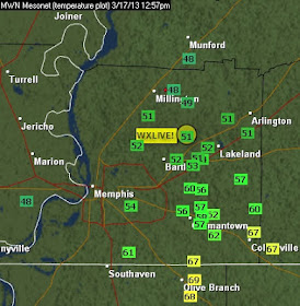
| 1pm temperatures across the metro as a stationary front lingers overhead |
Low pressure over the southern Plains will move just north of the front across AR and into the Ohio Valley by tonight. As it does, the stationary front will lift north as a warm front and a cold front will move towards the region from the west. As the stationary/warm front lifts north, more unstable and warm air will also move north, placing the metro in the "warm sector" of the approaching low pressure system.
 |
| Green line = stationary front draped over the metro at 1pm. Low pressure to the west will move NE, lifting the front north and bringing a cold front into the region late tonight. |
With the low moving in close proximity to the region and warm and moist air just to our south, the Mid-South will be in a corridor for potential severe weather. The stationary front will start lifting north this afternoon. As the sun sets, instability tends to wane - so we have a dilemma regarding the magnitude of the unstable air, which will have a direct effect on the strength of any storms.
It does appear that storms will be likely, however, and there is a risk of a few severe storms south of the path of the low, in the warm sector, and ahead of the approaching cold front. The area delineated by the Storm Prediction Center is the Slight Risk area (shown below) , or that zone where the possibility of strong to severe storms is enhanced. It includes the Memphis and Little Rock metro areas down to Texarkana and north to far western KY.
 |
| Slight Risk area as defined by the Storm Prediction Center. This area has an enhanced risk of severe weather. |
The most likely time for thunderstorms in the metro will be during the overnight hours, or after 10pm until about 4-6am (which doesn't technically make most of these storms St. Patrick's Day storms I guess). The cold front will arrive around dawn on Monday with the strongest storms in the hours leading up to that. Therefore, scattered strong storms are possible after 10pm, but more likely time for storms (with a few being severe) will be after midnight through dawn. The overall risk appears to be conditional - meaning that if certain atmospheric conditions are not met (namely sufficient instability), severe weather is not a given.
As for threats in the local area from any severe storms, there is a 15% chance of large hail (1" or larger), about a 10% chance of damaging wind (60 mph or greater), and less than a 5% risk of a tornado. So, while hail and strong wind are possible in the stronger storms, an isolated tornado cannot be ruled out.
 |
| (Top to bottom) Large hail, damaging wind, and tornado risk maps from SPC. |
We will effort to provide complete overnight coverage of this event on our Facebook and Twitter feeds listed below. Our nowcasting is our bread-and-butter product - and it's free. Tell your friends and stay safe!
----
Follow MWN on Facebook, Twitter, and Google+
Visit MemphisWeather.net on the web or m.memphisweather.net on your mobile phone.
Download our iPhone or Android apps, featuring a fresh new interface and StormWatch+ severe weather alerts!


No comments:
Post a Comment