Synopsis
It was a bit chilly this morning with temperatures dipping into the 50's with plenty of dry air in the region. This is all due to the long-wave trough that made its way through the region a few days ago. The main feature to focus on in the upcoming forecast is a short-wave trough which could bring some rain chances heading into tomorrow.
Analysis
 |
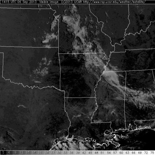
| Visible Satellite Image at 10:15 AM. Shows what the atmosphere looks like from space. |
|
Visible satellite image from this morning (10:15 AM) shows cloudiness associated with the aforementioned short-wave trough
[EP: Basically, an upper-level low pressure system over a somewhat small area...] over the Midwest. This feature will make its way into the area overnight, bringing us scattered showers. The question is how much this short-wave trough can dig, which influences how far south it goes.
 |
| NAM 500 mb (18,000') vorticity at 15Z Tuesday (10 AM Tuesday) |
Weather modeled mid-level vorticity for tomorrow morning (10 AM) shows this trough digging far enough south to bring us some scattered showers. The farther south it digs, the larger the potential coverage and intensity of rain. The colors in this map show vorticity; when this energy is moving into the area in the upper-atmosphere you can expect rising motion.
 |
| NAM 850 mb (5,000') temperatures and winds at 15Z Tuesday (10 AM Tuesday) |
Rising motion can also occur when warm air is advecting or moving into an area. This lower-level map from the same model shows warm air advection at that same time (10 AM). This gives further indication of rising motion and thus rain potential. However, we need to see if other requirements for thunderstorm development are present at this same time.
 |
| NAM sounding for Memphis, TN. Vertical profile of atmosphere at 15Z Tuesday (10 AM Tuesday) |
Other ingredients needed for thunderstorm formation vary. The above map shows a vertical profile of the atmosphere which can be extremely useful for diagnosing the condition of the atmosphere. This particular image is again a modeled image for the same time period (10 AM). This image reveals the biggest problem which is lack of moisture in the mid-levels of the atmosphere. You want the green line (dew point) to be as close to the red line (temperature) as possible to get clouds and rain. That same level in the atmosphere also has a small cap, or increase in temperatures with height. This feature prevents air from rising past it but can easily be eroded with enough heating.
Beyond tomorrow we can expect winds shifting to the south, bringing
warmer temperatures and slowly rising humidity headed toward the
weekend.
Conclusion
Chances for rain and thunderstorms are marginal given all of the atmospheric parameters. The short-wave trough and warm air advection promote rising motion but lack of mid-level moisture and weak temperature inversion will prevent widespread activity. Depending on how far south the trough can dig and how long it takes to move into the area will determine the extent of the strength and coverage of storms. If it digs farther south than this model anticipates then more upper-level energy will be present. More importantly the trough will slow down which will allow for more instability due to morning surface heating. Of course a later arrival would also push back precipitation a few hours toward the late morning to early afternoon.
William's Memphis Forecast
Monday
A few clouds with a high of 84, low of 65.
Tuesday
Scattered showers (mainly in the morning) with a high of 83, low of 67. 40% chance of rain.
Wednesday
A few clouds with a high of 87, low of 68.
Thursday
A few clouds with a high of 89, low of 70.
--William Churchill, MWN Social Media Intern
[Comments by MWN Meteorologist Erik Proseus noted and italicized]
----
Follow MWN on
Facebook,
Twitter, and
Google+
Visit
MemphisWeather.net on the web or
m.memphisweather.net on your mobile phone.
Download our
iPhone or Android apps, featuring a fresh new interface and
StormWatch+ severe weather alerts!


