Pages

Friday, January 31, 2014

A close look at potential winter weather on Sunday night

We've mentioned on social media that there are perhaps multiple scenarios in the coming week in which winter weather is possible. The first of those will be Sunday. We'll take a look at that in just a moment, but first what to expect between now and then.

Leading into Sunday, a very warm day is expected Saturday with highs near 60 and low rain chances.  Saturday night, rain is expected to move in as a cold front arrives between 9pm and midnight.  The front will cause temps to fall overnight to the mid 30s.  It appears that the overnight wave of precipitation will move out Sunday morning, so we expect that precipitation will remain all rain into Sunday morning despite it being cold.

During the day Sunday, we had thought a few days ago that it would be dry. Models are now painting a wetter picture as the front stalls just south of us and an upper-level low moves into the region. Temperatures should remain in the 30s, but above freezing, most of Sunday until the sun goes down so we're again expecting all liquid precip and a cold day.

By Sunday evening, as temperatures fall near the surface and aloft, there is a decent chance that precip will change to some wintry form before tailing off overnight.  In fact, leading to this measured degree of confidence is the fact that 3 of the major weather models that go out that far all show some form of wintry precip. Our best guess (subject to change of course) is that during the Super Bowl rain will mix with sleet and/or freezing rain, then to snow/sleet as temps continue to slowly fall, especially in west TN and eastern AR.

Total expected precipitation through Monday morning as forecast by the Weather Prediction Center. An inch of liquid -equivalent precipitation is possible across the metro, including Saturday night and Sunday's rain and Sunday night's mixed bag. Graphics courtesy WeatherBell.

Below you will see a couple of model graphics for midnight Sunday night that basically show a mixed bag of precip types in the area.  The top one is from the GFS, the bottom from the NAM (graphics courtesy WeatherBell).  The NAM seems to be showing some rain still around, but it also places the 32 degree line (in red) south of Memphis, so we believe it's precip type is a little off.

GFS model of precip type at midnight Sunday night. Green is rain, orange is sleet, pink is freezing rain, blue is snow.

NAM model of precip type at midnight Sunday night. Same color scheme as above.
Another interesting product to use comes from the NWS Winter Weather Desk at the Weather Prediction Center.  They produce probabilities of various winter weather events among other products.  The graphics below show the probability of measurable freezing rain (0.01"+) and 1" of snow in the 24 hours between noon Sunday and noon Monday (though precip should be gone by Monday morning).  Notice the freezing rain probabilities are fairly low (20-30% in the metro), but the chance of 1" of snow is decent, especially along and north of I-40 (higher than the ice probabilities anyway).  And of course these are probabilities of 1" occurring, so we can assume that the probability of ANY snow occurring (based on these graphics) is higher.

Freezing rain probabilities from the Weather Prediction Center from noon Sunday through noon Monday.

1"+ snow probabilities from the Weather Prediction Center from noon Sunday through noon Monday.
We're still 48-60 hours away from this potential event, so there obviously is still a degree of uncertainty, but the signals are present. We'll also continue to monitor the daytime hours Sunday in case models trend colder as moisture looks to remain in place.

After this event, Tuesday also looks wet, but warm enough for rain with precip moving out overnight as temps fall. The chance of wintry weather is fairly low Tuesday night. Cold weather sticks around and there could be another chance of mixed precipitation by Friday, however that is a week out so a lot can change. Stay updated with the latest info by following our social media channels and of course get the latest current metro conditions and the MWN Forecast via our mobile apps and website (all linked below).

--Erik Proseus, MWN Meteorologist

----
Follow MWN on Facebook, Twitter, and Google+
Visit MemphisWeather.net on the web or m.memphisweather.net on your mobile phone.
Download our iPhone or Android apps, featuring StormWatch+ severe weather alerts!

Thursday, January 30, 2014

A Mixed Bag: Warm and wet followed by possible winter weather

Overview:
After a much colder than average January for the Memphis metro we'll finally start to see a warmer pattern take shape for the next few days. A building ridge to our east will help bring warmer, moist air into the region into this weekend. As you can probably expect, with any warm flow coming off the Gulf you're also going to get plenty of chances for rain in the forecast. We'll wrap up discussion with a potentially significant system affecting the Mid-South next week (with relatively cold air in the area) before yet another arctic airmass overtakes the region.

January Climate Summary:
Before we talk about the upcoming weather, lets take a look at just how cold this January was.
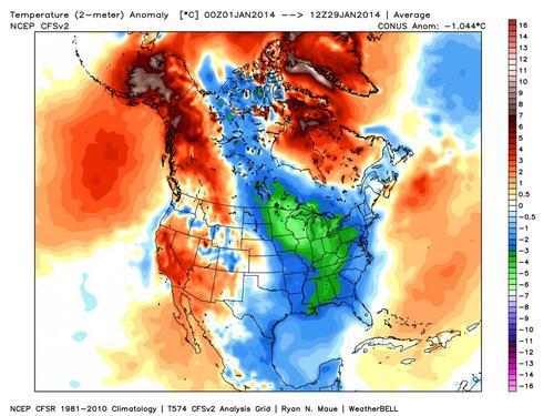
2-meter Temperature Anomalies for (most of) January
The above image shows an average of observed temperatures for the month of January compared to climatology. This indicates that Memphis was nearly 3° Celsius (~5.5° Fahrenheit) below average for the period. Another interesting climate statistic to point out is that Memphis averages 14.5 days out of the month with a low of less than 32°. This January we have had 23 days that meet that criteria! It has without a doubt been a frigid January, so now lets get into the details of the brief warm up.

Weather Discussion:
Significant warming begins today with gusty south winds ushering warmer, moist air into the Mid-South. Expect this to continue through Saturday with rain chances beginning Friday and increasing into Saturday.

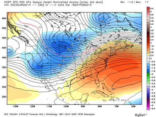
GFS 500 mb Normalized Geopotential Height Anomalies mid-day Saturday
Above is a modeled image of the middle sections of the atmosphere on Saturday. It showcases our warmer pattern with a ridge of high pressure to our east. The broad clockwise flow of this ridge brings warm, moist air from the Gulf of Mexico into the region.

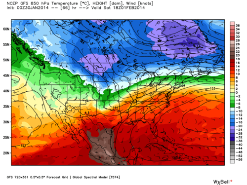
GFS 850 mb Temperatures and Winds mid-day Saturday
The effects of the ridge can be seen in the above modeled image of temperatures in the lower levels of the atmosphere. Relatively warm air can be seen as far north as New England (although snow pack in some of these areas works to prevent these warmer temperatures from reaching the surface).

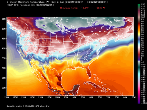
GFS 2-meter Maximum Temperatures for Saturday
Above are forecasted maximum temperatures for the same day, indicating temperatures as high as 60 degrees for the Memphis metro on Saturday.

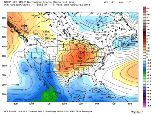
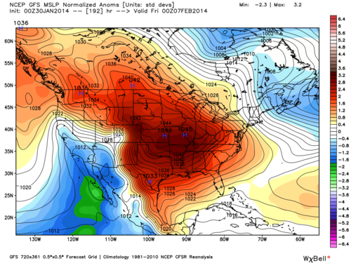
GFS Mean Sea Level Pressure Normalized Anomalies for Sunday night
Unfortunately a brief return to colder (but not frigid) temperatures is expected on Sunday as a cold front moves through the region. The above modeled image shows surface pressure conditions on Sunday evening, with a decent cold core high pressure system over the region. It's important to note that the orange colors do not represent warmer temperatures, but higher pressure values. Since this is a cold core high pressure system, this actually suggests cold temperatures.

Tuesday is where the forecast gets quite tricky, as we have relatively cold air over the area with a low pressure system and its associated precipitation setting up somewhere near the Mid-South.

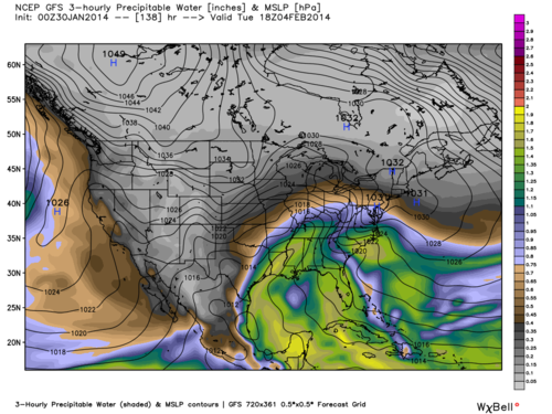
GFS 3-hourly Precipitable Water Values for Tuesday afternoon
Above is a modeled image of precipitable water values mid-day Tuesday. It is basically showing the extent of the deep moisture in the region due to the approaching low pressure system from the Gulf of Mexico. Values are peaking near 1.5 inches which is fairly significant for a potential winter weather event (given that relatively cold air being present at the surface).

Unfortunately I cannot answer all the questions concerning possible winter weather accumulations from this storm system (no one can this far out). This winter weather set up is similar to what we are used to with borderline temperature problems leading up to the event. We will not know for sure the extent of the cold air and the exact track of the low pressure system until the event is actually happening. Both of these things are extremely important as small changes in either factor will lead to huge differences in precipitation types and amounts. However, things will become a bit more clear over the next few days and we'll be sure to let you know when we have a better idea of possible precipitation types and accumulations. As of now we're confident the event will start as rain with a changeover of precipitation possible during the latter half of Tuesday and heading into Wednesday.

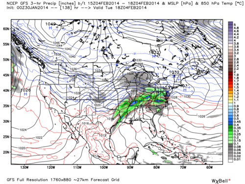
GFS 3-hour Precipitation Amounts and 850 mb Temperatures for Tuesday afternoon
Above is the same weather model's precipitation estimation for late Tuesday morning. This indicates some heavier precipitation is possible with the high amount of moisture present. Currently this model has the freezing line in the lower levels of the atmosphere farther north during the period of heaviest precipitation, meaning mostly rain with perhaps some change over at the end of the event (note that this is just one particular model solution, not a forecast).

GFS Mean Sea Level Pressure Normalized Anomalies for next Thursday night
One thing I can say with some certainty is that frigid temperatures are likely to return for the first weekend of February. The image above shows a huge area of arctic high pressure building in at the end of the modeled period (once again orange and red colors suggesting high pressure strength, not warm temperatures). Don't let this warm Saturday fool you, winter is certainly not over!

Get full details on the forecast from MWN by clicking here.

-William Churchill, MWN Social Media Intern

----
Follow MWN on Facebook, Twitter, and Google+
Visit MemphisWeather.net on the web or m.memphisweather.net on your mobile phone.
Download our iPhone or Android apps, featuring StormWatch+ severe weather alerts!

Monday, January 27, 2014

Frigid Tonight and Tomorrow with Gradual Warming Thereafter

Another arctic air mass is already affecting the Mid-South with frigid conditions expected through Wednesday night. Gradual warming is expected each day, building to the 50's expected Friday.

I'm sure most of our followers know by now that quite the rare winter weather event is setting up for a good portion of the Gulf and Atlantic coasts. It is fairly frustrating to be north of where the wintry action is taking place, so lets breakdown why that is.

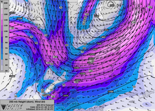
18z GFS 250 mb (jet stream level) heights and wind speeds for Tuesday morning
Above is an image showing wind speed and direction in the upper atmosphere. Depicted is a large area of winds in excess of 160 mph stretching all the way to northern portions of the Mid-South. This screaming jet streak is providing plenty of energy to the upper atmosphere that supports clouds and precipitation. You can actually see in the image a southern and northern component to the jet stream in the Mid-South. This is the subtropical jet and polar jets phasing together to create a very strong single jet stream. So it's not surprise that when this happens there is usually an area that gets nailed with heavy wintry precipitation (in this case the Carolina's).

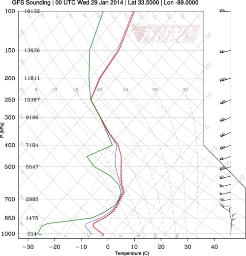
18z GFS atmospheric sounding valid for Tuesday evening
The above image is a modeled vertical profile of the atmosphere which puts into perspective our main problem here in the Mid-South for those who want snow. By Tuesday evening, dew points (green line above) could be less than -20 degrees Celsius, which indicates extremely dry, arctic air being pushed in from the north. This very dry air at the surface is the main reason we won't see snow (although flurries are a possibility). As snow begins to form and falls towards the surface in Memphis, it will inevitably evaporate in the dry air towards the surface. Farther south and east there is a better mixture of the wind energy and moisture that support larger snowfall totals.

18z GFS valid for midday Tuesday showing 2-meter temperatures
So finally we get to the real story in the Mid-South which is frigid arctic air. Above is a temperature anomaly map which shows temperatures as low as 20 degrees below normal during the day tomorrow. In fact, almost the entire eastern and central United States are well below average as the arctic air overtakes the region.

To break it all down in terms of a temperature forecast, expect a 10 degree rise in high temperatures each day. Mid 20's tomorrow, 30's Wednesday, 40's Thursday and 50's Friday. Of course the mornings will still be rather chilly (especially tomorrow and Wednesday with temps in the lower teens). Get full details on the forecast from MWN by clicking here.

-William Churchill, MWN Social Media Intern

----
Follow MWN on Facebook, Twitter, and Google+
Visit MemphisWeather.net on the web or m.memphisweather.net on your mobile phone.
Download our iPhone or Android apps, featuring StormWatch+ severe weather alerts!

Monday, January 20, 2014

Cold Locks in this Week with Little Relief

Hopefully the unseasonably warm weather today was well enjoyed because the weather looks to cool down quite quickly this week!

Two shots of cold air are on the agenda with the second later week blast being more potent than the first. Temperatures are expected to be below average the entirety of the week with some relief possible by the weekend. Lets get into the details of work-week, double-cold snap.


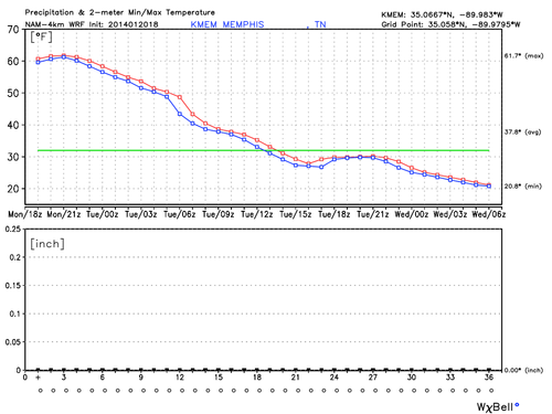
NAM-4km Min/Max Temperature and Precipitation Graph through midnight Tuesday night
This image paints a picture of the first cold snap as we see the comfortable 60's we experienced today succumb to the brutal arctic blast through Tuesday. Temperatures quickly fall tonight to just below 30 while not rebounding much at all tomorrow due to the constant surge of arctic air. Perhaps even more important to note is the lack of precipitation with this frontal passage due to a notable lack of moisture. This will also be the case with the second arctic blast.

Beyond the scope of the graph, temperatures will continue to drop Tuesday night into the teens before attempting to rebound during the day Wednesday to the lower 40's. This is due to the progressive nature of the weather pattern which shifts winds back to the southwest, aiding the sun in warming us to tolerable winter levels.

However, also typical of progressive patterns is quick shifts back to cold before too much warming can happen. This is exactly what we see Wednesday night with the passage of another arctic front, quickly dropping temperatures back into the lower 20's, then struggling to reach 30 on Thursday.

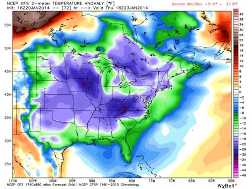
GFS 2-meter Temperature Anomaly valid for midday Thursday
The image above shows the severity of the below average temperatures according to one particular weather model (GFS). It depicts temperatures as low as 20 degrees below normal Thursday.

The situation does not get any better Friday as the progressive nature of the pattern slows down as north winds continue to usher cold air into the region on Friday. [Editor's note: thanks, William, for not calling this the "second coming of the polar vortex."]

As previously mentioned some relief is possible heading into the weekend but we're not too optimistic. So I hope you enjoyed the beautiful warm winter day today as the cold looks to lock in for awhile!

For the complete MWN forecast, with details on exactly how cold it'll be this week, click here or check our MWN mobile apps featuring StormWatch+ nationwide mobile weather alerts.

--William Churchill (MWN Social Media Intern)

----
Follow MWN on Facebook, Twitter, and Google+
Visit MemphisWeather.net on the web or m.memphisweather.net on your mobile phone.
Download our iPhone or Android apps, featuring StormWatch+ severe weather alerts!

Tuesday, January 14, 2014

DIRECTV rains on TWC's parade: what YOU have to say


Last night (Monday, January 13 at 11:00pm CST), the carriage contract between DIRECTV and The Weather Channel (a.k.a. "TWC" - Facebook, Twitter, Google+) expired without a new contract in place and DIRECTV promptly replaced TWC with WeatherNation (Facebook, Twitter, Google+), a new-ish broadcast weather service that identifies itself as "delivering 24/7 coverage of current weather events" and "real weather - pure and simple."

Because weather is an everyday topic of conversation and TWC is the 800 lb gorilla in front of the green screen (no, I'm not referring to any on-air talent), opinions and discussion are aplenty.  We won't go into the behind-the-scenes, or in-front-of-the-camera, verbal sparring that is taking place, particularly on TWC's end (which honestly is making TWC look petty and unprofessional, with scare tactics that approach a TORCON of 10).  What we did want to know was how YOU feel about it.  It's one thing for a bunch of weather geeks to throw their opinions around, but we're in the minority.  What's more important is what the general public perceives of the decision and, maybe more interestingly, what their perception of TWC is.

So we took an anonymous survey! And we have results!  First, a caveat: the survey questions were written by us to be as unbiased as possible, but the survey link was only distributed on MWN Facebook and Twitter feeds.  Since we have some very smart followers who tend to be more weather savvy than the average Joe, the responses likely lean a little more towards what the "above average consumer of weather information" might think. It's also worth noting that nearly two-thirds of those who responded to the survey are DirecTV customers, so they are directly affected.

Here are our survey results, based on 70 responses received by 2:30pm Tuesday (percentages may not total 100% due to rounding):

1. What do you think of the move to drop TWC from DirecTV's lineup?
A. I support DirecTV in dropping TWC: 42%
B. I support TWC. DirecTV needs to get them back on ASAP: 22%
C. It doesn't really matter to me: 36%

2. Overall, what do you think of TWC's current broadcast programming (not web or social media presence)?
A. It's great! I wouldn't change a thing: 7%
B. Decent, but I would make changes if I could: 16%
C. Mediocre. Not nearly what I would like to see: 52%
D. Poor. Nothing they broadcast is worth watching: 25%

3. How often do you watch TWC?
A. Routinely - daily or several times a day: 14%
B. Somewhat regularly (every few days at least): 13%
C. Rarely, and mainly during severe and high-impact weather events: 50%
D. Not at all: 23%

4. How often do you use TWC's online offerings (web, apps, social media)?
A. Multiple times a day: 9%
B. About once a day: 9%
C. A few times a week: 19%
D. Less than once a week: 29%
E. Never: 35%

5. Do you watch TWC or use their online offerings during severe weather events *locally*?
A. Yes, they provide excellent local severe weather coverage: 6%
B. Occasionally, but I tend to rely more on other sources for local severe weather info: 37%
C. No, I use other sources where severe weather affects me personally: 57%

6. Did you lose access to TWC with the decision by DirecTV last night?
A. Yes, and I'm considering changing providers: 7%
B. Yes, but I won't change providers: 58%
C. No: 35%

It's interesting to note that (in our informal survey), the majority of people do not use TWC when severe weather affects them personally, and nearly everyone else may watch TWC but rely more on local sources.  We believe that this has a lot to do with the availability of local information via multiple local broadcast stations and other internet-based sources like MWN.  (By the way, we agree that local is best when wanting the best possible forecast or warning information.)

Also of note is that nearly 3 in 4 respondents "rarely" or "never" watch TWC, which can be explained by question 2, which indicates that the same 3 in 4 find the programming "mediocre" or "poor." More surprising to us is that only 1 in 3 use TWC's online offerings (which we think more highly of than their broadcast) more than once a week.  Finally, with 45 respondents directly affected by DirecTV's decision, only 5 would consider changing providers due to this decision.  Sounds like DirecTV knew what they were doing when they decided to pay hard ball!

The comments on the survey, as well as those we received on Facebook and Twitter are also very telling.  People are simply tired of the lack of "pure weather" from TWC that WeatherNation seems to be capitalizing on.  Many comments were directed towards the increase in reality-based programming and the lack of true local weather information (especially for satellite consumers who weren't privy to true local info during "Local on the 8s").  In addition, many people negatively commented on the recent decisions by TWC to use TORCON (and other proprietary indices) and winter storm names, even describing it as egotistical, stupid, sensationalizing, and even "lacking in credibility."

To their credit, the main time people seemed to tune in was when a national weather event was unfolding (that didn't affect them directly) and they wanted a national perspective. We agree that the best programming, at least as far as we are concerned, is in this area.

Here are a sample of comments we received on Twitter, which seemed to also reflect the opinions we received in our survey:


So, will TWC be back on DirecTV?  I believe they will, and probably before long.  (On the other hand, the CEO of TWC says it's possible they may never be back on DirecTV.)  However, I also believe that they have done possibly-irreparable damage to their brand in the past 48 hours, especially when the consensus seemed to be that their programming wasn't all that great to begin with.

The true winners in this deal, by good fortune and because they didn't allow themselves to get drug into the mud on it, is WeatherNation. Some comments I have seen from those in high places at TWC about WeatherNation staff and their company philosophy honestly should require a public retraction and apology (here from TWC's CEO and here from Al Roker for example).  This is not WeatherNation's fault - they simply positioned themselves to be in the right place at the right time, with the type of product that people were seeking. I don't know enough about WeatherNation to grade them or outright recommend them, but from what I have seen, they appear to be well-positioned for growth using the very basic formula that TWC started with years ago - all weather, all the time.

Thanks for your survey responses and also for mentioning us as a trusted local weather source over and over again!  If you have any comments on the DirecTV/Weather Channel controversy, let us know below or hit us up on social media.

Erik Proseus
Meteorologist and Founder
MemphisWeather.net

----
Follow MWN on Facebook, Twitter, and Google+
Visit MemphisWeather.net on the web or m.memphisweather.net on your mobile phone.
Download our iPhone or Android apps, featuring StormWatch+ severe weather alerts!

Monday, January 13, 2014

Roller-coaster temps this week thanks to mainly dry cold fronts

Temperatures this week will mimic some of the best roller coasters around as multiple cold fronts move through the area.  Fortunately, the fronts will be moisture-starved, bringing little to no rain with them it appears.  The fronts will be noticeable to Mid-Southerners however, marked by cold weather and gusty north wind behind them and warmer days as wind shifts back to south ahead of the next front.  This is what we refer to as a "progressive pattern," meaning that systems do not stall out, but continue moving through every couple of days.  Much like a roller coaster car that doesn't stop in the valley or at the top of the hill, but heads straight for the next loop!

The image below is taken from this morning's GFS (American) computer model showing near-surface temperatures for the next 7 days.  High temperatures for each 6 hour period are in red and low temperatures for each 6 hour period in black.  The daily highs are labelled with the vertical axis on the left indicating the temperatures in degrees F.  Friday morning's low is also labelled as it will be the coldest morning this week.  I'll bet you can even pick out about when the fronts will come through!  Precipitation is represented by blue bars (scale to the right for amounts in inches).  You'll notice that after today's rain (the first 2 blue bars), there is no more precipitation expected from the GFS until early next week, despite the hills and valleys in the temperatures.

GFS Monday morning model data showing temperatures in pink and black (highs and lows for each 6 hour interval, respectively) and precip (blue bars).  Warm temps are expected Tue, Thu, and this weekend, while cold days will be Wed and Fri when highs will probably stay in the 30s!

The official MWN Forecast calls for pleasant days on Tuesday (with a very small chance of a shower as the first front moves through) and Thursday with cold, windy days on Wednesday and Friday.  A moderating trend is expected this weekend.  It looks like another cold snap will arrive early next week.  Overall, a not-unexpected pattern for the middle of winter and thankfully not as cold as the start of last week!

Follow us on Facebook, Twitter, or Google+ for multiple updates each day (links below)!

--Erik Proseus
MWN Meteorologist

----
Follow MWN on Facebook, Twitter, and Google+
Visit MemphisWeather.net on the web or m.memphisweather.net on your mobile phone.
Download our iPhone or Android apps, featuring StormWatch+ severe weather alerts!

Wednesday, January 8, 2014

Winter Weather Advisory: light icing expected Thursday AM

It seems we can't catch a break from wintry weather, and yet no good snowfall!

Before we ended our 67-hour streak of below-freezing temperatures this morning at 10am, the National Weather Service had issued a Winter Weather Advisory for the metro, in effect tonight until noon Thursday.  An upper-level disturbance will move across the area Thursday, bringing with it a good chance of precipitation.  Unfortunately, the remnants of the Arctic outbreak linger and temperatures will be near freezing for at least a portion of the precipitation period.

Winter Weather Advisory area in purple

Without going into much detail on model data, we'll just say it's not been cooperating and confidence in the event has been, and still continues to be to an extent, somewhat low. However, I'm convinced of a couple of things: precipitation will fall and temperatures will (as usual) be tricky, floating near the freezing point for perhaps a good part of the time precip is falling. The main concern for this event will be ice and the potential for hazardous travel conditions, mainly Thursday morning.

Light precipitation has already broken out across portions of AR and this will shift east this evening. Since our starting point for temperatures will be the lower 40s this evening, I expect intermittent periods of mainly light rain or sprinkles from the evening hours into the early overnight period as the lower atmosphere moistens up (the air is very dry in the lowest 3,000'). As it moistens, surface temperatures will be falling into the 30s. Some sleet could mix with the light rain after midnight through about 6am. This will not be a steady period of precipitation through 6am, but rather intermittent "showery" type of precip.

After 6am, and especially after 8am, temperatures will be hovering near the freezing mark as steadier precipitation arrives. The steady, but overall light, precip is expected to last throughout the morning.  The big question - and one that models disagree on - is temps during the morning hours.  One camp says they warm up during the precip resulting in very minor ice accumulations.  The other (and one we put more faith in for METEOROLOGICAL reasons, not HYPE), keeps temps near freezing for much of the morning.  The reason: with steady precip and cloud cover and no movement of warm air into the area from a warmer source nearby (advection), we don't see temps rising much on their own until precip tapers off some. If precip were to be more spotty than we are expecting, then temperatures likely would be a touch warmer and we'd see more rain than ice.

Below you'll see two graphics from the winter weather desk at the Weather Prediction Center at NOAA: the probability of accumulating (at least 0.01") freezing rain and the "worst case" freezing rain accumulation, defined here by the 90% threshold.  In other words, there is only a 10% chance of exceeding the values shown in the second image.  Our chances of accumulating freezing rain are near 100%.  The "worst case," according to WPC, is near 0.10".  (However it should be noted that one model that has been consistent for a couple of days says we get nearly 4 times that during the morning hours. It's an outlier, but it's also a consistent one.)

Probability of freezing rain accumulating at least 0.01" by noon Thursday

"Worst case" map showing the 90th percentile freezing rain accumulation, meaning there is only a 10% chance an area will see more than indicated.

The bottom line

So our forecast is for spotty light rain this evening through midnight, mixing with a little sleet after midnight.  The rain will become light freezing rain mixed with sleet by dawn as temps hit 32, then change back to rain showers by late morning as temps warm above freezing.  No (or VERY little) snow is expected due to above-freezing temperatures aloft. Total freezing rain/sleet accumulations could be up to 0.20" though will more likely be closer to 0.10".  The low will be 31 and tomorrow's afternoon high 40, though we'll be in the 31-34 range throughout the morning.

One-tenth of an inch of ice is enough to cause bridges/overpasses to freeze.  I understand TDOT is already on the roads pre-treating.  This is a wise move.  Plan ahead for tomorrow morning's commute.  By afternoon, I expect very few problems with rising temps, but the morning could be dicey.  I don't know about schools closing, but I do know you working parents want them in school after an extended winter break! LOL  Follow our social media accounts listed below for updates and more detail as they become available.

----
Follow MWN on Facebook, Twitter, and Google+
Visit MemphisWeather.net on the web or m.memphisweather.net on your mobile phone.
Download our iPhone or Android apps, featuring StormWatch+ severe weather alerts!
Monday, January 6, 2014

The Meteorologist Rants...

Yes, I agree... we need to get a good ground-covering, snow angel-making snowfall!  Not because I like to throw snowballs (though I do), or my kids like to play in it (they do), or because snow days rock (hey, most of you are getting out tomorrow anyway!) - but to get some of you off our backs.  "Our," as in your local meteorologists (and yes, I'm speaking on behalf of a small, fairly tight-knit industry without their permission).

You know we're in Sales, not Production, right?  We don't make the stuff that falls from the sky, and contrary to what some of you think we don't have a direct line to the Creator, or Mother Nature, to "dial up" a snow storm (even though we occasionally pretend like we do). Trust me, if we did, we wouldn't be spending hours agonizing over computer model data and trying to figure out the influence of the bluffs, the Pyramid, and I-40 (I kid...).

Technical explanation for Sunday's lack of snow

In the case of this past weekend, I knew several days in advance that Sunday was going to bear watching. I saw model data that predicted up to a couple of inches of snow 2-3 days in advance of the storm and tried to balance that with the local knowledge (something the national personality and some app with millions of downloads doesn't have) that the particular setup doesn't favor a couple of inches of snow in these parts. When a massive cold front sweeps through the South in winter, it's very typical for the cold air to chase the moisture.  If it catches up with it, which occasionally happens, we get a little snow. More often that not, we get what we saw Sunday - light snow that didn't accumulate.

This event was a little different in that a low pressure system was going to move northeast along the front and right through our area. Personally, I thought the models might have been on to something when all agreed 2 days in advance that the low would move by just east of Memphis, thereby bringing in the cold air (sufficient for snow) by about noon. Precip after that time looked sufficient for minor accumulations, perhaps up to an inch. By Saturday, models were back-pedaling, showing the low going by to our WEST. This meant a 2-4 hours delay in the arrival of the cold-enough-to-snow air.

Sure enough, as models continued on that trend, I reduced our snow accumulation forecast. In fact, I showed the graphic below on Facebook and Twitter Saturday with the comment that the snow total in that model (the NAM) was "potential" and that we thought it was a "high end estimate." By Sunday morning, the MWN Forecast was down to "possibly 1/2 inch" accumulation.  We ended up not even getting that.


So the problem on Sunday was not the amount of moisture or the timing of it, but the delay in arrival of cold air.  For instance, MWN in Bartlett received 0.43" of rain Sunday prior to a change to snow at about 3:00pm.  The amount of rain that fell between noon and 3pm was 0.20".  If the change to snow had occurred at noon, as we thought a couple of days earlier, we would have been making snow angels in 1.5"-2" of snow late Sunday afternoon.

The rant

Despite big gains in recent years, the science (more like art, really) of meteorology is not advanced enough to pinpoint exact snow totals or where tornadoes will hit days in advance. It's like predicting the top 10 finishers in a NASCAR race with 43 drivers.  Possible, but highly unlikely. We (most in the industry) work hard to give the BEST information possible given the knowns and unknowns and using our local knowledge and experience.

Having said that, I feel it's ALWAYS better to be prepared and NOT have disaster happen, than to miss a high-impact event. However, this doesn't mean we forecast worst-case. While I personally am always looking to improve based on additional experience, I will not apologize for doing my best to tell you what I expect to happen, my confidence in that forecast, the impacts that could occur, and how you should be prepared. The information we as meteorologists have to examine is getting better (and more voluminous) all the time and our experience and knowledge grow with each event, but we are NOT perfect and never will be. I do promise to give you the facts, NOT hype, and help you to "be prepared, not scared." If disaster doesn't happen, count your blessings.

To end, here's the best suggested response I have seen to someone who wants to throw the first stone, courtesy of Jon Acuff, author of "The Hater Handbook":


Thanks to so many of you for your encouraging words. But I don't do this for praise, I do it because it's what I love. Now to go check the latest data on that freezing rain potential Thursday morning... :-)

Erik Proseus
MWN Meteorologist

----
Follow MWN on Facebook, Twitter, and Google+
Visit MemphisWeather.net on the web or m.memphisweather.net on your mobile phone.
Download our iPhone or Android apps, featuring StormWatch+ severe weather alerts!
December & 2013 Annual Climate Data and MWN Forecast Accuracy

December was marked by huge temperature swings and periods of rain and thunderstorms with several days also seeing very light winter precipitation. When averaged out, temperatures averaged just below normal and precipitation was also below normal at the airport but above normal in other areas of the metro where precipitation was more persistent.  There were two periods of well above normal temperatures (70s), including a couple of record-setting days, while the colder days tended to be very cold with highs in the 30s. Climate details for December, as well as the year 2013, can be found below.

Memphis International Airport, Memphis, TN - December

The average temperature for the month of December was 43.0 degrees, or 0.6 degrees below normal. The average high temperature was 51.4 degrees (0.7 degrees below normal) and the average low was 34.6 degrees (0.5 degrees below normal). The coolest temperature of the month was 22 degrees, reached on the 7th, while the highest temperature was 76 degrees on the 4th and 21st. There were 17 days which saw low temperatures below 32 degrees and one day in which the high did not reach 32.  The low of 61 degrees on the 20th set a record (1931) for the warmest minimum temperature on record for that date. The high of 76 degrees on the 21st also set a record (1967) for the warmest temperature on record for that date.

Precipitation for the month totaled 4.82", which was 0.76" below the average monthly rainfall for Memphis International. There were 11 calendar days with measurable rainfall and one which saw 1" or more.  The greatest 24-hour rainfall occurred on the 20th-21st with 1.95" of precipitation. There were 4 days one which light freezing rain was recorded, 4 days with sleet recorded, and 2 days on which light snow fell.  In sum, 5 days had some form of winter precipitation, however totaling only a trace for the month.

The peak wind was 49 mph from the south on the 21st with an average wind speed for the month of 7.4 mph. The average relative humidity was 71 percent and average sky cover was 70 percent. Click here for a daily statistical recap for Memphis International Airport.

Memphis International Airport, Memphis, TN - 2013 Annual

For the year, the official mean temperature for Memphis was 62.1 degrees with an average high of 71.2 and an average low of 53.0.  The mean is 1.0 degrees below normal, while the average high was 1.3 degrees below normal and the average low 0.6 degrees below normal.  There were 62 days with temps of 90 or greater (2.3 below normal), 58 days with lows at or below 32 (15.2 days above normal), and 3 days with highs at or below 32 (1.4 below normal).

Periods of warm and cold weather are evident in the daily average temperature graphic, particularly in the running mean (shown below). Very warm weather started the year, followed by a cool spring, average summer, then warm early fall and cool start to winter.


Precipitation totaled 59.43" for the year, which is 5.75" above normal, but almost two feet more than 2012. There were 114 "rain days" (measurable precip recorded), which is 6.3 above normal, and 18 days with more than one inch of rain. The wettest day of 2013 was May 21, which recorded 4.18" of rainfall. Snowfall totaled a trace (normal is 3.8") with 11 days recording a trace of snow.

The last freeze in the spring was March 24th and the first fall freeze was November 12, resulting in a growing season of 232 days.  The average wind speed was 7.6 mph, the peak wind was southwesterly at 61 mph on January 29.  Average sky cover was 60%.  Average relative humidity was 65%.  For a summary of 2013 from NWS-Memphis for each of it's climate locations, including Memphis, click here.

Cirrus Weather Solutions, Bartlett, TN - December

The average December temperature at Cirrus Weather Solutions was 41.9 degrees with a maximum of 76.1 degrees on the 4th and a minimum of 18.0 degrees on the 12th. There were 18 days with lows below 32 degrees and 1 day with a high below freezing.

Monthly precipitation was higher than at the airport and measured 5.26" via the Cirrus automated gauge, as well as the manual gauge used for the CoCoRaHS program. Maximum daily precipitation was 1.66" on the 21st on the automated gauge. The measured peak wind gust was 20 mph on the 4th. Average relative humidity was 81%. Click here for a daily recap on MemphisWeather.net.

Cirrus Weather Solutions, Bartlett, TN - 2013 Annual

For the year, the average temperature at MWN was 60.5 degrees with a maximum temperature of 98.9 degrees recorded on June 27th and a minimum of 17.9 degrees on November 28th.

The CoCoRaHS manual rain gauge recorded 56.78" of precipitation, while the automated rain gauge recorded 54.80".  The peak wind speed was 29 mph on March 24th with a dominant direction for the year of southwesterly.  The mean barometric pressure reading was 30.08" and the mean relative humidity 76%.

MWN Forecast Accuracy

For the month of December, the average temperature error in all MWN temperature forecasts was 2.39 degrees, lower than all available computer data models and the National Weather Service forecasts. MWN's forecasts extend out five periods (2.5 days, or roughly 60 hours). Over 62% of the MWN temperature forecasts for the month were within 2 degrees of the actual temperature. For dewpoint accuracy, the MWN forecast averaged 2.80 degrees error and fell within 2 degrees of the actual dewpoint over 56% of the time.

For the year, the average temperature error in all MWN temperature forecasts was 2.13 degrees, lower than all available computer data models and the National Weather Service forecasts. Over 68% of the MWN temperature forecasts were within 2 degrees of the actual temperature. For dewpoint accuracy, the MWN forecast averaged 2.44 degrees error and fell within 2 degrees of the actual dewpoint over 62% of the time.

Historical accuracy statistics can be found here.

----
Follow MWN on Facebook, Twitter, and Google+
Visit MemphisWeather.net on the web or m.memphisweather.net on your mobile phone.
Download our iPhone or Android apps, featuring StormWatch+ severe weather alerts!
Friday, January 3, 2014

Looking ahead to Sunday's Arctic plunge: snow & bitter cold

Temperatures in the lower half of the 30s today will feel like spring warmth by early next week, following an Arctic cold front that moves through Sunday morning. And certainly don't get used to the upper 40s expected Saturday!

Rain chances increase Saturday night ahead of the front being shoved across the eastern U.S. by a massive dome of cold air straight from the north pole.  Rain will be likely Sunday morning with temps in the 40s, however as soon as the front passes through (between 8-11am), cold air pours into the region and we'll reach the freezing mark by noon, if not a bit quicker.  When that happens, rain will change to snow.  The amount of moisture left behind the 32-degree line determine the amount of snow we get.  This is not a case of whether it will get cold enough, because it WILL be cold enough!

Current estimates from various computer models range from a heavy dusting (0.5-0.75") up to a couple of inches.  Our current forecast is for a good inch in the metro, more to the north and less to the south.  It is conceivable that some spots in the metro could see up to 2", however we believe that to be on the high side.  Rain should change to snow by noon with the heaviest prior to 3pm, then flurries possible into the early evening.

European model forecast of precipitation between 6am-noon Sunday and the freezing line at noon (dark blue). MWN believes the cold air might get here an hour or so quicker than this shows. Rain vs. snow is NOT depicted in this image.

European model forecast of temperatures at noon Sunday. Notice how quickly temps transition from 40s to 20s!
The other concern Sunday will be the rapid nature of the falling temps.  Rain that falls before temps reach 32 could quickly freeze on all outdoor surfaces and bridges/overpasses in particular could "flash freeze," meaning that sitting water turns to ice in very short order.  We expect to see temps in the 20s by late afternoon.

This will begin a period of below freezing temps that will last until Wednesday, or as much as 72 hours, including periods of extreme cold (for the South).  Low temperatures in the city will be near 10 Monday and Tuesday mornings, Monday's high will only be in the middle teens, and wind chills Monday morning will drop below zero!  Areas outside the city proper can subtract at least a couple of degrees from those morning low temps. It's been 4 years since we've had lows that cold and maybe as far back as February 1996 since we've seen highs in the teens.

European model graphic of forecast temps and precip through next week. Click for larger image.
Now is the time to prepare for winter weather Sunday and bitter cold for 3 days.  See the graphic below for information from the NWS on cold weather preparation.

Cold weather preparedness from NOAA.  Click for a larger view.
We'll have more information and updates to the forecast on our website, mobile web, and social media platforms, all listed below, in the coming couple of days.  In addition, plan to join us Saturday night at 8pm for a Google+ Hangout on our expectations for the coming several days.  You'll be able to watch live via Google+ or YouTube, or watch a recording after the fact.  Links will be posted on MWN and our social feeds.

----
Follow MWN on Facebook, Twitter, and Google+
Visit MemphisWeather.net on the web or m.memphisweather.net on your mobile phone.
Download our iPhone or Android apps, featuring StormWatch+ severe weather alerts!