After a few lovely days we will be reminded yet again that the cold isn't quite done yet! However, you'll be pleased to know that the impending cold front is not of the arctic variety. Enjoy the rest of today as the front plans to make its appearance tomorrow morning and temperatures will struggle to rise in its wake. Lets take a look at the cause of the cold front and its impacts on the Mid-South tonight and tomorrow.
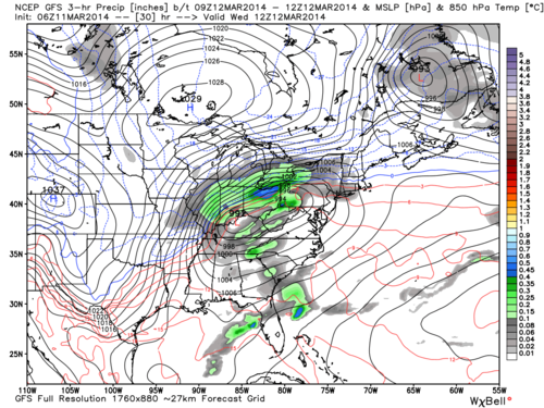 |
| GFS 3-hr precip total, sea level pressure and 5000' temperatures valid at 7AM Wednesday. |
The above depiction of sea level pressure and precipitation by the GFS model shows a low pressure to our northeast by 7AM tomorrow. This indicates that we will not have much to deal with in the way of precipitation with the front as the majority of the best lift and moisture remain closer to the low pressure system itself. Lets zoom into the Mid-South with the use of a high-resolution model.
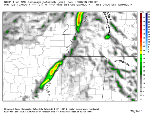 |
| NAM 4-km Composite Reflectivity ("Future Radar") valid at 4AM Wednesday. |
The NAM model suggests a brief shower is possible in the early morning hours as the cold front makes its way through the Memphis metro. A shower is also possible overnight while we remain in the warm, relatively unstable air mass.
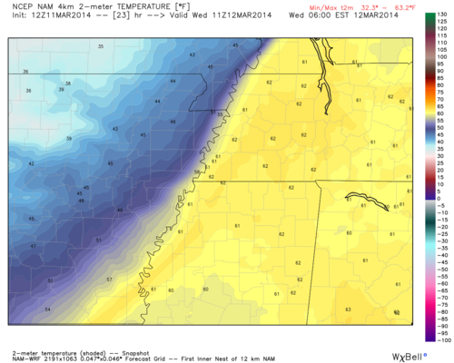 |
| 4km NAM near-surface temperatures valid at 6AM Wednesday. |
By 6AM the difference in temperature east and west of the Mississippi River is quite dramatic. This shows the potency of the cold front as it progresses east during the morning hours. Expect a drastic drop in temperatures into the 40's around this time tomorrow morning.
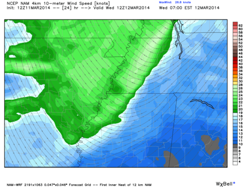 |
| 4km NAM near-surface wind speed and direction valid at 7AM Wednesday. |
The NAM also shows a distinct wind shift to the northwest typically indicative of a cold front. This occurs as the low pressure to our north progresses eastward, wrapping air around it counter-clockwise. As a result it will be quite windy tomorrow, especially in the morning, making those 40's feel quite a bit colder. Expect decreasing clouds as well as cold, stable air works to reduce cloud cover.
Looking out a little further, temperatures will rebound behind the front as we head towards the end of the week, but not quite to the levels of the past couple of days. In addition, mornings will be colder as cool, dry high pressure moves overhead.
For details, reference the full MWN forecast at our
website.
--William Churchill, MWN Social Media Intern
----
Follow MWN on
Facebook,
Twitter, and
Google+
Visit
MemphisWeather.net on the web or
m.memphisweather.net on your mobile phone.
Download our
iPhone or Android apps, featuring
StormWatch+ severe weather alerts!


No comments:
Post a Comment