South of the high pressure that moves by to our north, a low pressure system over south Texas will get its act together and also move east along the Gulf coast. The Mid-South ends up in a squeeze play with cold air from the north moving in as moisture wraps around the low to our south. This is one of our classic winter weather patterns, but it always depends on the details, which are never the same from one storm to the next. How cold will it get and how much moisture will be present. As usual, the intersection of the "just cold enough" air and available moisture will be right over the region. There is still disagreement in the models on the amount of precipitation and degree of cold air. Yesterday, most models were still in the "no precip" camp, but they are coming around.
 |
| NWS forecast position of the low pressure responsible for potential Mid-South snow. The "Gulf low" track is a favorable one for the production of snow in the winter in Memphis. |
So, tell us straight - how much are we talking and schools be cancelled?
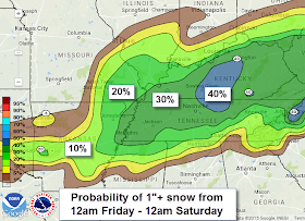
A big factor on any snow accumulation is the fact that we have been warm recently, so streets and even the ground have warmed up a bit from our early January deep freeze. For now, my early expectation is that some areas in the metro might see up to in inch of snow, mainly on grassy or exposed surfaces. Most major and secondary roads would be fine in this scenario, though slick spots could develop in those areas that get slick first - bridges and overpasses. (Note that brine pre-treatment, if applied, will wash off prior to any snow falling. It won't do any good.)
I have NO IDEA about schools, and they aren't making a decision this early anyway. The scenario could completely change by Friday morning. A couple of degrees either way could result in snow amounts ranging from nothing to a few inches based on the amount of precipitation expected. For now, plan ahead for all possibilities and let those paid to make those decisions Friday morning do their job, which always involves the safety of the children over anyone's convenience.
 |
| From the NOAA/NWS Weather Prediction Center - probability of 1" or more snow on Friday. A low chance of 1" doesn't mean no snow however. |
We'll update again as new information arrives or our opinion changes, but no later than Thursday afternoon. Any intermediate updates will be posted on our Facebook and Twitter feeds.
Erik Proseus
MWN Meteorologist
----
Follow MWN on Facebook, Twitter, and Google+ for the latest from your trusted local source
Visit MemphisWeather.net on the web or m.memphisweather.net on your mobile phone.
Download our iPhone or Android apps, featuring StormWatch+ severe and winter weather alerts!


No comments:
Post a Comment