 |
| Departure from normal precipitation for the past 30 days. Yellow/orange are below normal, green/blue above normal. A good part of the Mid-South could use some rainfall. Graphic courtesy NOAA |
Thursday through the weekend
The main spring severe weather events the past several days have been over the central and southern plains. However, the main system that has been nearly stationary and responsible for the plains storms will eject east late this weekend. Ahead of that, waves of energy from the parent system will move towards the Mississippi River Valley over the coming days. Models disagree a bit on how far east the rain chances get, but I wouldn't be surprised to see a few showers or a thunderstorm tomorrow (Thursday) afternoon during the afternoon, and again on Friday.Rain and storm chances look a little higher Saturday, then diminish a bit by Sunday before the main system moves through on Monday with scattered to widespread showers and thunderstorms. Severe weather threat is limited at this time, but we'll be watching Monday closely as the time gets closer. Temperatures will remain above normal with highs in the mid 80s (perhaps a few upper 80s this weekend if we get enough sun) and mild lows in the 60s. Normal highs and lows for this time of year are near 80 and 60, respectively.
Once the main system exits early next week, I expect lower precip chances, cooler weather, and comfortable humidity levels on north wind heading into the middle of next week, just before the Memphis in May Barbecue Contest commences.
Tropics
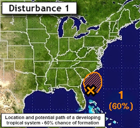
Meanwhile in the western Atlantic, the first potential tropical disturbance is "on the radar" of meteorologists, despite the start of the Atlantic tropical season still over 3 weeks away. The storm, should it become a subtropical or tropical storm, would be called Ana and looks to affect the Carolina coastline this weekend with rain and wind, though the strongest part of the storm would be well offshore, at least initially. See the precip graphics above for possible rainfall totals. |
| The first subtropical or tropical storm of the year could form by this weekend and would be named Ana. |
A new partnership for MWN!
For those who have not read our announcement on social media or in the MWN Newsletter, MemphisWeather.net has partnered with the Memphis Redbirds to provide local weather updates as needed for the 2015 baseball season. We're very excited about this partnership and look forward to serving the Redbirds players and staff, as well as the fans in the stands, over the course of the season! For full details, click here. We have one more big announcement coming soon as well, but can't quite let the cat out of the bag just yet on that!
Enjoy the "early summer" weather and be sure to have sunscreen on when spending more than just a little while outside over the coming days! The May sun, even with some clouds, is enough to burn you!
Erik Proseus
MWN Meteorologist
----
Follow MWN on Facebook, Twitter, and Google+
Visit MemphisWeather.net on the web or m.memphisweather.net on your mobile phone.
Download our iPhone or Android apps, featuring StormWatch+ severe weather alerts!


No comments:
Post a Comment