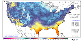
That is surely the case for the 72 or so hours spanning yesterday through Sunday. In the wake of a cold front, cool air under a Canadian high pressure system and abundant cloud cover served to keep temperatures in the 50s Thursday, prompting complaints from some about it being too chilly. As the clouds departed last evening and the high pressure system settled over, wind became light and temperatures fell into the 40s area-wide, including an official low of 48 at Memphis Int'l Airport and 43 at MWN in north Bartlett. (41 is the record low for the airport, so it was not in jeopardy.)
Today, temperatures are rebounding nicely with sunny skies, dry (low humidity) air, and easterly flow around the high bringing temps into the mid 70s. Today is a transition day as even warmer air arrives from the south as the high pressure moves east, resulting in low 80s on Saturday for the grand finale of the Memphis in May AutoZone Sunset Symphony, of which MemphisWeather.net is proud to be the Official Weather Partner! Fortunately, humidity will remain low, but sunscreen will be a good idea if you plan to be at Tom Lee Park, or outdoors for any length of time elsewhere.
By late Saturday night, a warm front will move north across the region and bring a small chance of rain or a t'storm. On Sunday, we'll be back in the "warm sector" with humidity back to late spring levels (dewpoints in the mid 60s), a chance of t'storms, and highs in the mid 80s.
Unfortunately for those who have seen enough rain of late, this pattern sticks around for much of next week it appears. Daily rain chances in the 40-60% range will occur beginning Memorial Day (have a plan B for your grill-outs and picnics) and lasting at least the first half of the week. Highs will be in the 80s, lows near 70, noticeable humidity, and southerly wind. No severe weather is currently expected, though upper-air impulses that can't be timed just yet could serve to intensify precipitation somewhat during the first half of next week. Also of some concern will be rainfall amounts as daily storms could result in flash flooding at some point next week - just in time for the kids to be out of school and summer fun to start!
 |
| The NOAA Weather Prediction Center's rainfall forecast through Wednesday. Another very wet several days across the rain-soaked Southern Plains into the Mid-South! |
Stay tuned and we'll keep you posted on any threat you need to be aware of. Be sure to always get the latest via our social media feeds and MWN mobile app as well. All pertinent links can be found below.
Erik Proseus
MWN Meteorologist
----
Follow MWN on Facebook, Twitter, and Google+
Visit MemphisWeather.net on the web or m.memphisweather.net on your mobile phone.
Download our iPhone or Android apps, featuring StormWatch+ severe weather alerts!


No comments:
Post a Comment