Pages

Tuesday, January 31, 2017

Memphis, TN Annual Climate Summary for 2016

2016 Annual Recap

Overall, 2016 was very warm (only 0.1° short of the all-time warmest, in fact) and alternated between abnormally wet (especially in the spring) and drought (in the fall).


The year started off with a roller coaster January featuring both severe weather and the only winter weather event of 2016. A mix of snow and ice occurred on the 22nd with the official report being 0.3" of snow, though up to 3" fell in Tipton County.

NWS-Memphis graphic showing approximate accumulations from the January 22 winter storm. (NWS-Memphis)
After temperatures were near average in January, the warmth of 2016 started in February with temperatures and precipitation both above normal. The month of March was particularly eventful with multiple heavy rain events leading to flash flooding, as well as a Tornado Warning on the 13th. Temperatures were also well above normal. April continued the trend of above normal temperatures. During the month of May, which typically commences summertime warmth, unusually cool temperatures were experienced mid-month with highs in the 60s and only a couple days above 90°. Only a few spotty severe weather events occurred during the prime severe weather season of April and May.

June began a period of very warm weather and dry conditions that would continue through the summer and into the fall. The month featured 22 days above 90° and was the seventh warmest June on record. Drought conditions began to show up in north MS. July and August continued the hot trend with both months ranking in the top 10 warmest on record and the three-month summer term ending as fourth warmest on record. In fact, persistent heat is best reflected by the fact that a new record was set for consecutive days with low temperatures at or above 70° (83 days ending September 1). Precipitation was fairly abundant locally during July and August though drought conditions continued in north MS.

September continued to be very warm with 20 of the first 25 days of the month above 90° and the month ending as second warmest on record. That was followed by the warmest October on record. Both months were also very dry with drought conditions in north MS spreading north into the metro and most precipitation falling on just a few days. Fall ended with November ending as the eighth warmest on record and the September-November period being the warmest fall on record, as well as the sixth driest. Precipitation in November was sparse, resulting in severe drought conditions across the metro.
A comparison of drought conditions on November 29, when severe drought covered the metro, and January 3, when it was greatly alleviated due to late November and December precipitation. Can't see the animation? Click here. (UNL Drought Monitor) 
Winter began with a wide variety of weather in December - warm spells separated by Arctic blasts and stormy periods that included some severe weather reports in the middle (wind damage, funnel clouds) and end (hail) of the month.

All severe and winter weather reports in the metro area received by NWS-Memphis in 2016. Click for larger image

Memphis International Airport, Memphis, TN

Temperature
Average temperature: 65.8 degrees (2.7 degrees above average)
Average high temperature: 75.3 degrees (2.8 degrees above average)
Average low temperature: 56.2 degrees (2.6 degrees above average)
Warmest temperature: 100 degrees (July 22)
Coolest temperature: 15 degrees (December 19)

Heating degree days: 2437 (527 below average)
Cooling degree days: 2807 (549 above average)
Days at or above 90 degrees: 96 (31.7 days above average)
Days at or below 32 degrees: 36 (4.2 days below average)
Last freeze/first freeze: February 26-December 8 (286 day growing season)

Records set or tied: Sixteen warm weather and zero cold weather records were set or tied during 2016. The daily records included: January 31 (61°, tied warmest low), February 2 (75°, record high), March 15 (82°, tied record high), June 17 (81°, record warmest low), June 25 (80°, tied warmest low), July 26 (80°, tied warmest low), August 2 (81°, tied warmest low), August 10 (81°, tied warmest low), August 30 (79°, tied warmest low), September 15 (98°, tied record high, and 78°, record warmest low), September 24 (97°, record high), September 25 (98°, record high), October 29 (85°, tied record high), October 31 (87°, tied record high), and December 17 (76°, tied record high).


Comments: 2016 was the 2nd warmest year on record with a 65.8° average annual temperature, finishing 0.1° short of the record set in 2012. June-August (meteorological summer) was the 4th warmest on record (84.3°) and September-November (meteorological fall) was the warmest on record (69.5°). In addition, June (83.2°) was 7th warmest, July (85.0°) was tied for 8th warmest, August (84.6°) was 10th warmest, September (80.5°) was 4th warmest, October (70.7°) was 1st warmest, and November (57.4°) was 8th warmest on record. The six-month stretch of top 10 warmest months is remarkable and resulted in the June-November period (76.9°) being the warmest such stretch on record.

Temperatures for the year (lows/highs) are plotted in dark blue against the normals (brown), record highs (red) and record lows (light blue).  Where the dark blue extends above or below the brown indicates temperatures above or below normal, respectively.

Precipitation
Monthly total: 61.59" (7.91" above average)
Days with measurable precipitation: 115 (17.3 days above average)
Days with 1"+ precipitation: 25 (7.6 days above average)
Wettest day: 4.53" (March 9)

Total Snowfall: 0.3" (3.5" below average)
Days with a trace or more snowfall: 4
Greatest snow depth (at 6am CST): Trace (January 22)

Records set or tied: Three daily records were set in 2016: March 9 (4.53"), March 10 (3.43"), March 31 (2.42", tied).

Comments: 2016 was the 18th wettest year in 146 years of record-keeping, boosted by the 4th wettest meteorological spring (March-May, 27.24"). Countering that, meteorological fall (September-November, 4.45") was the 6th driest on record. March (16.20") was the 4th wettest on record, aided by three daily records during the month, and July (8.02") the 8th wettest.

Precipitation accumulation for 2016 is plotted as the dark green line, compared with a normal year in brown. Precipitation was near normal until a very wet early March. After that point, it remained near average with slight variations, through August before a lengthy dry spell that resulted in drought conditions heading into early winter. Much of the positive departure from normal resulted from deluges in early spring.

Precipitation totals for the NWS-Memphis area of responsibility with individual totals plotted. (NWS-Memphis)
Miscellaneous
Peak wind: East/66 mph (July 20)
Average wind: 7.4 mph

Click here for monthly/daily statistical recaps for Memphis International Airport.

Cirrus Weather Solutions / MemphisWeather.net, Bartlett, TN

Temperature
Average temperature: 63.4 degrees
Average high temperature: 74.8 degrees
Average low temperature: 52.9 degrees
Warmest temperature: 99.4 degrees (July 22)
Coolest temperature: 13.6 degrees (December 20)

Heating degree days: 3015
Cooling degree days: 2433

Precipitation
Annual total: 53.55" (automated rain gauge), 54.94" (manual CoCoRaHS rain gauge)
Wettest date: 3.79" (March 9-10) (CoCoRaHS)

Total Snowfall: 0.9"
Days with a trace or more snowfall: 2
Greatest snow depth: 1.0" (January 22)

Miscellaneous
Peak wind: South/30 mph (January 31)
Average relative humidity: 76%
Average barometric pressure: 30.07" Hg

Click here for monthly/daily statistical recaps for Bartlett, TN.

MWN Forecast Accuracy

Number of forecasts produced and rated in 2016: 553
MWN average temperature error: 2.16 degrees
MWN forecast temperatures within 2 degrees of actual: 66.4%
MWN average dewpoint error: 2.29 degrees
MWN forecast dewpoints within 2 degrees of actual: 65.9%

MWN's forecasts extend out five periods (2.5 days, or roughly 60 hours) and the numbers above represent the error/accuracy of the entire 2.5 day period. Historical accuracy statistics can be found here.

----
Follow MWN on Facebook, Twitter, and Google+
Visit MemphisWeather.net on the web or m.memphisweather.net on your mobile phone.
Download our iPhone or Android apps, featuring StormWatch+ severe weather alerts!

Sunday, January 29, 2017

Fairly quiet weather week ahead; warm, then cooler

A couple of rather seasonal late January days provided for decent weather this weekend in the Mid-South. A brief warm-up will occur the next few days before another cold front moves through, knocking temperatures back down to near average levels. No major Arctic blasts are forecast to affect the Memphis area in the next week or so.

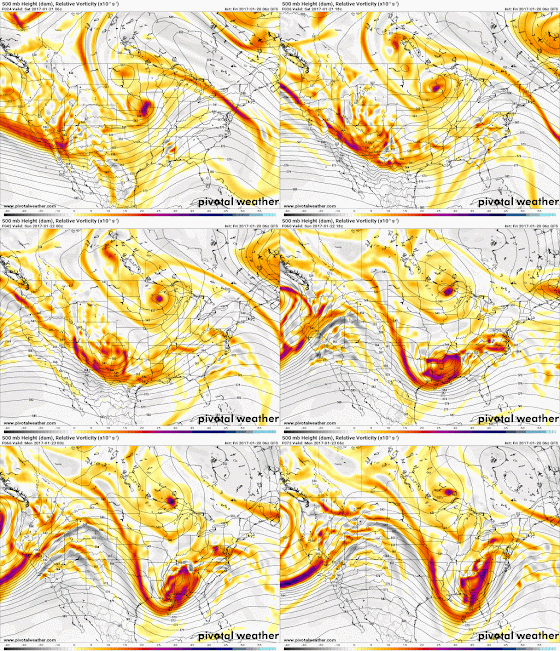
The lower level weather is being driven by what's going on in the upper level of the atmosphere. Today, that includes a large ridge of high pressure over the western half of the country and a fairly substantial trough along and east of the Mississippi River.

The American GFS model shows a large eastern U.S. trough and major upper level ridge over the western U.S. this evening. These features exist at about 30,000' up in the atmosphere. (PivotalWx)
In the north-northwest flow around that eastern U.S. trough, a wave of energy brought today's cloud cover, as well as light precipitation well to our north and east. In fact, big fat wet snowflakes fell in the Nashville metro this morning with temperatures in the upper 30s. As you can see from the animation below, which shows the pressure pattern and jetstream at about 30,000', that dip (or trough) in the wind flow will shift east as the large ridge to our west flattens out a bit.

An animation through the work week of the same level, from the same model, as above. Notice the trough exits east as the upper level patter becomes more "zonal." Towards the end of the loop, more wind energy is poised to move across the Mid-South late in the week. Can't view the loop? Click here. (PivotalWx)
That shift will serve to place a bit more ridging over the Mid-South, resulting in more sunshine and warmer conditions as we head into the work week. You can see the temperatures at about 5,000' respond accordingly in the beginning of the animation below. Blues (colder than average air) moves east and is replace by reds, indicating warmer than average temperatures. Surface temperatures will also warm with highs about 5° warmer on Monday than Sunday (mid to upper 50s) and another nearly 10° warmer on Tuesday, in the mid 60s. It'll once again feel like an early taste of spring!

An animation of 5,000' temperature anomalies (departures from normal) through the upcoming work week indicate colder then average air (blues) shifting east early in the week as warmer than average temperatures (red) seep across the southern U.S. The coldest air this week remains bottled up to our north. Can't view the loop? Click here. (PivotalWx)
Looking back at the first animation above, you'll see the jetstream sink south a bit about halfway through the loop. This reflects a lowering of pressure, which then causes it to dip south. As it does, a cold front moves through on Wednesday with cooler conditions at the surface also occurring.

Light precipitation is forecast over the area early Friday morning by the GFS model as a weak upper level disturbance moves through. Being 5 days out, the timing of these upper systems can be off by a day or so, but the pattern for most of the country is one of fairly benign weather. (PivotalWx)
We'll be back to near average temperatures for the latter half of the week with more cloud cover and sporadic, mainly light, rain chances. The upper level pattern remains fairly zonal (flowing west-to-east) through the end of the week, so any weather systems that move through will do so fairly quickly with low rain chances and no major cold outbreaks.

Next weekend, the pattern becomes a bit more active as upper level energy moves in from the west and causes the upper level patter to "buckle" a bit, resulting in a bit stronger weather systems and likely some higher rain chances a week out. Timing of these is difficult, but the overall pattern suggests a bit more active weather. We'll keep an eye on it for you!

The American GFS model forecasts a more significant system next weekend (Sunday morning in this forecast) that could bring heavier rain to the Mid-South. It's worth noting that the European model is much less bullish with this system but rain chances do appear higher next weekend than they do during the work week. (PivotalWx)
For the complete MWN Forecast, updated daily by trained human hands and mind, download the MWN mobile app or check our mobile or desktop website. Links can be found below.

Erik Proseus
MWN Meteorologist

----
Follow MWN on Facebook, Twitter, and Google+
Visit MemphisWeather.net on the web or m.memphisweather.net on your mobile phone.
Download our iPhone or Android apps, featuring StormWatch+ severe weather alerts!
MWN is a NOAA Weather Ready Nation Ambassador Meteorologist Erik Proseus is an NWA Digital Seal Holder

Thursday, January 26, 2017

AMS: Best Practices for Sharing Weather Information on Social Media

Earlier this year at the American Meteorological Society's (AMS) 2017 Annual Meeting in Seattle, the AMS Council adopted a set of "best practices" for publicly sharing weather information via social media. As most of you are aware, there are many choices when it comes to consuming weather information. From local TV, to national cable channels, to government and private company websites, to NOAA Weather Radio, to social media, to mobile apps, and even your refrigerator... anyone (or anything) can produce weather data. That information may originate from a degreed or certified meteorologist, a broadcaster or reporter, a young person with passion but little to no training (that was me 25 years ago!), or (more often these days) just a computer model run through the Internet of Things.

At MemphisWeather.net, we our proud of the fact that our forecasts are human-powered by a meteorologist with 25 years experience in the Memphis area and our social media content is generated by either that same meteorologist, who also holds the National Weather Association Digital Seal, or meteorologists-in-training under the careful tutelage of said meteorologist. We have espoused the practices adopted by the AMS since our first tweet in April 2009. In the vein of full disclosure and public transparency, we thought it would be a good idea to list those best practices and let you decide if you agree with our (admittedly-biased) assessment. Here is a statement from the document on who should observe these practices:
The best practices outlined below aim to encourage the dissemination of high-quality weather information to the general public on social media platforms (i.e., mobile and web-based technologies)...These best practices are also designed to help social media users know what to look for and what to avoid when seeking weather information.
In other words, the best practices are an outline not only of what good weather information should look like on social media, but also what you should expect from your "trusted sources." With that, here they are, with sub-comments (in parentheses) edited only for length.

Best Practices for Publicly Sharing Weather Information Via Social Media

The overall goal should be delivering a time-sensitive product that communicates weather information clearly and professionally commensurate with the users’ understanding of the science. A quality social media weather information service should:

  • Differentiate between short-range forecasts, extended-range forecasts, and outlooks. (In short- or medium-range forecasts (i.e., less than 7 days), offer as much detail as the science allows. Do not imply that extended-range forecasts (i.e., 8 days and beyond) are as reliable as short-range forecasts. Clearly identify outlooks as such and avoid misrepresenting an outlook as a specific forecast of weather elements for a specific area.)
  • Recognize the limitations of numerical weather predictions. (When displaying or sharing computer model forecasts, identify them as such. )
  • Communicate uncertainty and be transparent. (When displaying or sharing forecasts that are highly complex and/or involve longer lead times, communicate the full range of scenarios. Communicate the degree of confidence in their forecasts and educate their users about the level of agreement among forecast models and the likelihood of a particular outcome. Respond to all comments and replies to their social media posts in a manner that offers insight into their forecast reasoning while being professional and respectful.)
  • Carefully and responsibly craft headlines and key messages. (If providers work in organizations where they do not have total control of all weather-related content, they should work diligently to educate and influence the appropriate content producers regarding the responsible communication of weather information.)
  • Offer a schedule for updates (While a regular schedule may not be applicable, providers of social media weather information should advise users when they can expect more information.)
  • Include NOAA watch, warning, and advisory products or hazardous weather outlooks.
  • Use discretion when disagreeing with “official” NOAA forecasts, especially during high-impact events. (The reasoning behind the forecast and the disagreement should be explained.)
  • Alert the public about appropriate response to severe weather events.
  • Include climatology information. (Put the current or predicted weather conditions into perspective with background climatology.)
  • Identify where and when weather data originated and provide appropriate credit.
  • Provide links to other relevant data. (This is especially true during hazardous weather situations when the user may need a source for weather alerts or information about the appropriate response to the hazardous weather.)

So, do we measure up? Let us know what you think in the comments. We promise none will be censored! And thanks for trusting MemphisWeather.net for your weather needs!


----
Follow MWN on Facebook, Twitter, and Google+
Visit MemphisWeather.net on the web or m.memphisweather.net on your mobile phone.
Download our iPhone or Android apps, featuring StormWatch+ severe weather alerts!
MWN is a NOAA Weather Ready Nation Ambassador Meteorologist Erik Proseus is an NWA Digital Seal Holder

Tuesday, January 24, 2017

Brrr! Winter Returns to the Southeast This Week

Where has old man winter been for the past few weeks? Well, he has been found and is coming back again to the Memphis area, bringing temperatures that are much more seasonable for the metro. First, though, we need to get through our next chance of rain.

A Wet Wednesday Commute?

After a beautiful day throughout the area on Tuesday, clouds will be increasing overnight tonight ahead of some potential showers in the morning. The chance for rain comes as a low-pressure system moves into the Midwest, with a cold front dragging through the metro tomorrow morning. Ahead of this front, there will be the chance of light rain in the morning hours, though not consistent across the entire area. Best to have your umbrella ready for the morning commute or when dropping the kids off at the bus stop.

The surface analysis for 6am Wednesday shows the potential for light rain tomorrow morning across the Memphis area as a cold front approaches. Make sure you have your umbrellas for the early commute!
Once the cold front clears the area, expect clouds to clear and temperatures on Wednesday night to drop off significantly. After much of the metro reaches the mid 60s in the afternoon, temps overnight will slide down into the 30s. There will also be a significant wind shift, as a strong westerly wind will arrive Wednesday late and continue into Thursday.

The Winter Thaw Is Over (For Now?)

Heading into later this week, temperatures will return to around normal for this time of year around Memphis. This means the 60s and 70s are gone, and will be replaced by the chilly 40s during the day. Overnight temperatures will be cold too, with lows most nights around 30, with a few potentially in the upper 20s.

Where is the cold air coming from? As the low-pressure system that brings rain to our area on Wednesday morning (and snow to our friends in the Upper Midwest) exits, the cold air trapped over the mountains in the west will spill into the middle of the country, effectively silencing the winter thaw seen over early January.

Watch as the cold air on this temperature map (denoted in the blues), pours into the central states over the next 24 to 36 hours, per the Tuesday mid-day run of the North American Model (NAM). (COD.edu) (If loop doesn't load, click here to view.)
While conditions look colder into the weekend, the sky will be mostly sunny throughout the day. However, early signs suggest another warming trend is coming for the first week of February. As always, we’ll keep you covered on your upcoming Memphis weather with our team here at MWN.


Stay ahead of the storm by downloading our MemphisWeather.Net mobile app for your iOS or Android devices and get our human-engineered forecasts at your fingertips. Also be sure to follow @memphisweather1 on Facebook and Twitter for more great content! Links are below to download the app or follow us on social media.

Alex Herbst, Meteorologist
MWN Social Media Intern

----
Follow MWN on Facebook, Twitter, and Google+
Visit MemphisWeather.net on the web or m.memphisweather.net on your mobile phone.
Download our iPhone or Android apps, featuring StormWatch+ severe weather alerts!
MWN is a NOAA Weather Ready Nation Ambassador Meteorologist Erik Proseus is an NWA Digital Seal Holder

Saturday, January 21, 2017

Potential severe weather tonight, more storms Sunday

A bright sunny day with highs in the 70s in January sometimes ends with a bang. As in thunder. That appears to be the case tonight as storms, some potentially strong to severe, move through the Mid-South. Enjoy the awesome weather today, then be prepared for the likelihood of thunder and lightning as you retire for the night, or enjoy an evening on the town for some.

As one line of storms moves into the southeast coastal areas, another system starts organizing to our southwest. It will move our direction tonight. In the meantime, sunny skies prevail.

Today and tonight

A severe line of storms moved by to our south early this morning and is now trucking through southern GA and northern FL. Unfortunately, deaths were confirmed in Hattiesburg as a tornado likely touched down in the wee hours this morning. As that line moves away, sinking air behind the system is resulting in sunny skies behind it.

However, looking southwest, another storm system is brewing as low pressure starts moving east into the southern plains, preceded by upper level impulses that spin off the parent low. One such upper level wave will force scattered thunderstorms to form late this afternoon over the ArkLaTex area and move east-northeast. These storms will quickly become severe with large hail likely and a few tornadoes possible.


Storm threats

As we head into the evening hours, those storms will move towards across southern AR into north MS. The Memphis metro will be on the northern edge of where the strongest storms are expected, but we will likely see a round of thunder and lightning, with some residual hail or maybe a few strong wind gusts possible. The hail threat is a result of the strong updrafts in the storms and very cold air aloft. The updraft strength will weaken some as we head late into the evening, but cold air will still be present, so very large hail is not expected in the metro, but 1" severe hail is possible. Tornadoes are also not likely locally as the tornado parameters and overall shear diminish as storms approach, though an isolated tornado cannot be ruled completely out. High-resolution models with hourly forecasts indicate that a broken line of storms embedded in rain will move into the southern metro after 10pm and likely move through the heart of the city around midnight (+/- an hour), exiting to the northeast by about 2am. (Hopefully the storms hold off until after the parking lots around FedExForum empty after a Grizzlies win over the Rockets!)


A loop of forecast radar from 6pm Saturday to 6pm Sunday via the high-resolution NAM model shows storms arriving tonight around midnight and additional showers and thunderstorms on Sunday as the low passes just to our north. (PivotalWx)

A Sunday round

After the storms exit, we expect a lull in the activity until around sunrise or so Sunday morning, when more scattered showers and some thunderstorms arrive and continue off and on into the early afternoon hours as highs climb to near 60. This activity will be in response to the surface low pressure system currently in NM moving just north of Memphis. Due to the very cold air aloft associated with the low itself, a few storms tomorrow could produce small hail. By late afternoon, the low passes, wind shifts to the northwest and becomes gusty. Showers end during the evening as temperatures fall to near 40 by Monday morning with wind chills in the mid 30s.

The surface pressure and wind fields at noon Sunday from the GFS model show the main surface low pressure system just north of Memphis and moving east. As it passes, wind shifts to the northwest and becomes gusty with showers wrapping around the low tapering off in the evening hours. (PivotalWx)

Looking ahead

A cooler day is on tap Monday with highs only in the lower 50s as clouds move out. A couple "warmer" days near 60 are expected Tuesday and Wednesday before a significant pattern shift takes place that results in more winter-like temperatures, but dry weather, to end the week. Highs will be in the 40s and lows in the 20s to near 30.

With severe weather possible tonight after dark and probably after bedtime for most, we highly recommend having a way of receiving severe weather information. We encourage you to check out our MWN mobile app and add the StormWatch+ upgrade within the app. You can set the warnings you want to receive and only receive them for the specific location(s) you select. Tornado and Severe Thunderstorm Warnings are alerted with "wake-me-up" style audio, while the rest use your default notification sound. Check the app out in your app store or click the link below. We'll also be nowcasting the storms as they move through tonight on our social media feeds, which can be found below as well.

Erik Proseus
MWN Meteorologist

----
Follow MWN on Facebook, Twitter, and Google+
Visit MemphisWeather.net on the web or m.memphisweather.net on your mobile phone.
Download our iPhone or Android apps, featuring StormWatch+ severe weather alerts!
MWN is a NOAA Weather Ready Nation Ambassador Meteorologist Erik Proseus is an NWA Digital Seal Holder

Friday, January 20, 2017

Potentially stormy weekend ahead then... SUN returns!

** UPDATED 1:15PM FRIDAY**

After a week of rain, cloudiness, and an occasional rumble of thunder, next week is looking sunnier already. However, here in the metro we need to get through one of more weekend of unsettled weather before that bright sunshine sticks around for at least a few days.

While the sun will peek out this afternoon, a round of upper level energy will set up additional showers and thunderstorms overnight tonight and into early Saturday. Most of this activity will remain south of the Memphis area, but a few storms could potentially reach the metro. Saturday will see a break in the storms by midday, before the severe weather threat increases late in the afternoon and into the evening hours. This threat could carry into the overnight hours, particularly south of the metro.


The highest risk for severe weather will be south of the metro, south of a line from Oxford to Tupelo, where an Enhanced Risk, or category 3 of 5, exists. A Slight Risk (category 2 of 5) includes theMemphis metro and points north to Jonesboro, AR and Jackson, TN. The unstable air mass moving across the area could generate severe thunderstorms capable of producing heavy downpours, large hail, damaging winds, and isolated tornadoes.

Showers and thunderstorms are expected to continue into Sunday, with the severe weather threat limited over the metro area. Occasional heavy downpours, small hail, and gusty winds cannot be ruled out in these storms, however. More than likely these thunderstorms will move across as the low passes overhead Memphis in the morning to early afternoon hours.

An upper level low (oranges/reds rotating counter-clockwise and moving across the southern U.S.) sweeping west to east across our area, coupled with an unstable air mass, could bring severe weather to the Memphis area on Saturday and into early Sunday. Weather will improve into early next week, however, as the low moves east. (If image above does not animate, click here.) (PivotalWx)
As the upper level low that brings these storms lifts out of the region by the end of the weekend, some SUNSHINE will help kick off your work week. Temperatures will drop slightly, highs will still be around the 60° mark.


By the end of next week, we could see a return of more winter-like temperatures, with the mercury dropping overnight into the 30s and highs only in the 40s. You may have been asking where winter was, and it appears Mother Nature is ready to remind us!

Be prepared for this weekend’s severe weather by following us on social media for the latest information. Since the threat of severe weather could continue into the overnight hours on Saturday, having at least a couple ways to receive severe weather alerts is important. You can download the MemphisWeather.net app from your app store and add StormWatch+ for severe weather alerts for your hometown pushed to your phone or tablet. All pertinent links are listed below.

Alex Herbst, Meteorologist
MWN Social Media Intern

----
Follow MWN on Facebook, Twitter, and Google+
Visit MemphisWeather.net on the web or m.memphisweather.net on your mobile phone.
Download our iPhone or Android apps, featuring StormWatch+ severe weather alerts!
MWN is a NOAA Weather Ready Nation Ambassador Meteorologist Erik Proseus is an NWA Digital Seal Holder

Monday, January 16, 2017

Potentially Stormy Week Ahead in Memphis

Is this winter or is this spring? With a chance of showers and thunderstorms throughout the week ahead and temperatures in the 50s and 60s, many are wondering where Mother Nature sent away winter to and when it might come back.

Severe Potential on Monday Night

Showers and a few thunderstorms have been rolling through northern Mississippi, Arkansas, and western Tennessee throughout the day on Monday, but will increase in number and intensity into Monday night. A slow-moving system that helped bring lots of ice and wintry conditions to the Central Plains is driving a Marginal Risk (category 1 of 5) for severe weather this evening, mainly along and west of the Mississippi River.

With a Marginal Risk (category 1 of 5) of severe weather this evening across the Memphis metro, be on the lookout for heavy downpours, thunder, and some strong winds on occasion. These storms should weaken by the overnight hours. (NWS/SPC)
The key takeaways from the threat of these storms will be locally heavy downpours, thunder, and brief strong wind gusts. Not every passing shower or thunderstorm will produce these, however. Showers may continue into the overnight hours and early on Tuesday, but the thunderstorm threat should abate by about midnight tonight. Temperatures this evening will fall off into the mid to upper 50s. Winds continue out of the south between 10 to 15 mph.

Continued Showers Possible

More showers and an isolated thunderstorm are possible throughout the rest of the week as this expansive low pressure system slowly inches east. A cold front should be passing through the region early Tuesday morning, with a wind shift accompanying it from the south to the west. Temperatures will fall off slightly, with highs in the upper 50s to low 60s on Tuesday and Wednesday. Overnight lows should only drop off into the upper 40s to mid 50s, a far cry from how low those temps should be this time of year. (Our average low temperature in mid-January is near the freezing mark!)

The same system that brought very icy conditions to the Central Plains this weekend will slowly push east, bringing a continued chance of showers and thunderstorms through this week for the Memphis area. The map above is valid at 6pm Tuesday. (NWS/WPC)

Another round of rain/storms

Temperatures will rebound on Thursday, with highs in the mid-60s in the metro, but with an increased chance of showers and thunderstorms as the slow-moving stationary front to our south continues to push out and low pressure develops to our southwest and moves across the area. A couple of those storms could be severe Thursday afternoon and into the evening. However, that rain will give way to a good start to your weekend, with temps nearing 70 degrees and partly sunny skies on Friday into Saturday. Lows remain comfortable for January, in the mid-50s, just cool enough to need a light jacket when taking the kids to school in the morning.

Early next week

As one system exits our picture late this week, another is taking shape over the west coast. That system could once again bring showers and thunderstorms late in the weekend into early next week to the Memphis area, with the best chance coming on Sunday. A chance of showers continues to hold in the forecast through at least Monday, with temperatures taking a dive into the 50s for highs and 40s for lows to start your next work week.

Where is winter, you might ask? Most of the eastern U.S. has been under well above average temperatures for the past week or so. However, long range models suggest that warm pool will be cooling off and winter-like temperatures could make a comeback as soon as the end of this month.

NOAA's 8-14 day temperature outlook covering January 24-30 suggests that warmer temperatures across the eastern half of the country will weaken, letting old man winter back in. (NWS/CPC)
Be sure to stay on top of the human-powered MWN Forecast this week and into the next by downloading the MWN mobile app or bookmarking our website. We’ll provide continuous updates on our social media platforms as well. Links to all of these tools can be found below this post.

Alex Herbst, Meteorologist
MWN Social Media Intern

----
Follow MWN on Facebook, Twitter, and Google+
Visit MemphisWeather.net on the web or m.memphisweather.net on your mobile phone.
Download our iPhone or Android apps, featuring StormWatch+ severe weather alerts!
MWN is a NOAA Weather Ready Nation Ambassador Meteorologist Erik Proseus is an NWA Digital Seal Holder

Thursday, January 12, 2017

20s to 70s - it's winter in Memphis!

For those of you who were tired of the 88 hours of sub-freezing temperatures we had late last week and into the weekend, you got your wish. We're back in the 70s! Welcome to the bipolar weather of Memphis, where lingering snow one day is completely melted by 60s and 70s the next day!

Arrival of a cold front

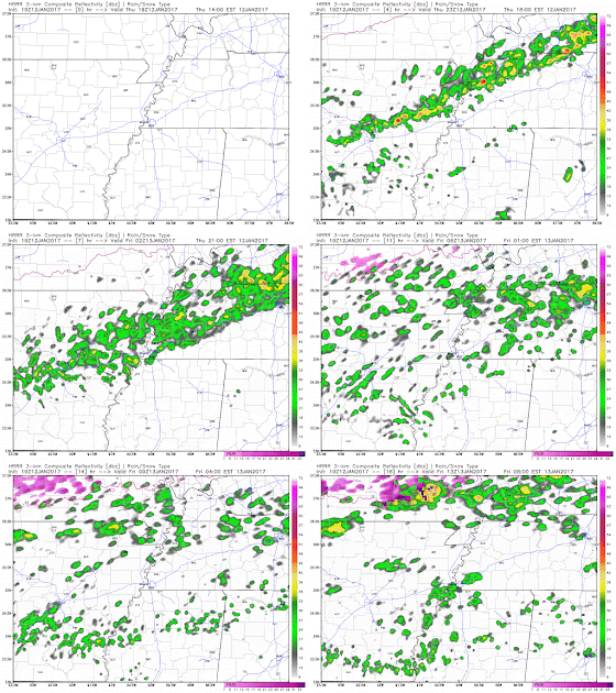
A general warm pattern looks to continue well into next week, but we do get a reprieve of closer-to-average conditions tomorrow, as a cold front moves across the metro this evening, lingers just to our south into Saturday, then makes a return trip back to our north as a warm front this weekend. If you're out and about this evening, you'll likely notice the front between 8-10pm as warm and humid conditions give way to showers and then a shift in the wind to the north, accompanied by a roughly 20-degree temperature drop. Here's forecast radar for this evening and overnight showing the rain:

Forecast radar for the evening and overnight hours from the HRRR model. If the GIF doesn't animate, click here. (WxBell)

Friday into the weekend

With the front stalling just to our south, the much cooler surface air combined with a strong temperature inversion (warming air with increased height, rather than typical cooling) and abundant low-level moisture that produces a low cloud deck, will result in much cooler temperatures tomorrow. Look for morning bus-stop temperatures in the mid 40s and highs not much warmer, in the lower 50s. A cool northeast breeze will provide a stark contrast to today's tropical breezes and mid 70s highs!

A vertical cross-section of the atmosphere at 6am Friday, according to the NAM model, clearly shows the inversion and low-level moisture that develops behind tonight's cold front. The inversion will serve to trap low clouds in place until sometime Saturday, resulting in much cooler and overcast conditions.
The inversion and cloud cover remain in place Friday night and into Saturday, keeping temperatures nearly steady Friday night near 50° and introducing the possibility of areas of dense fog. By Saturday afternoon, some sun may break out as the front starts to return back to the north. allowing the mercury to climb back to 60° or higher. Sunday promises to be a day not unlike the last couple with highs once again pushing the 70° mark and some afternoon sun expected between the clouds. With the exception of a stray shower, or drizzle Saturday morning, most of the weekend looks to be dry.

Next week

Looking at next week, a large scale system to our west, that is held at bay through the weekend by the Bermuda High pressure system over the southeast U.S., will start slowly moving east. A few showers are possible Monday, mainly afternoon and evening, as highs reach near 70° again. By Tuesday and probably into early Wednesday, periods of heavy rain and some thunderstorms are possible as the system, and it's upper level low, cross the region. Temperatures will remain mild, so there are no winter weather concerns, but not as warm as Sunday and Monday. We'll be watching rainfall amounts closely as some flooding is possible if heavy rain is prolonged.

The NWS predicts a solid 2" of rain for the metro over the next week with heavier amounts to our west where some impactful icing is also possible this weekend. (WPC/NOAA)
For those looking for more "winter-like" conditions, there are some long-range signs of a pattern shift late in the month. Cross your fingers! You can always check for details out a week in advance in the MWN mobile app or on our website. Look for the human-powered MWN Forecast!


Erik Proseus
MWN Meteorologist

----
Follow MWN on Facebook, Twitter, and Google+.
Visit MemphisWeather.net on the web or m.memphisweather.net on your mobile phone.
Download our iPhone or Android apps, featuring StormWatch+ severe weather alerts!
MWN is a NOAA Weather Ready Nation Ambassador Meteorologist Erik Proseus is an NWA Digital Seal Holder

MWN Interview: Dr. David Stephens, "Winter Weather in a Southern School District"

Earlier this week, MemphisWeather.net meteorologist Erik Proseus had the opportunity to sit down with Bartlett City Schools Superintendent Dr. David Stephens to talk about winter weather, and specifically the process a southern school district goes through in preparing for and executing operations when winter weather is forecast. Though his answers apply specifically to Bartlett, from our conversation it was clear that the process is fairly similar in other districts in the area. What follows is a Q & A from our conversation, edited for length. At the end of the post, you'll find a link to the audio of the entire conversation, as well as a full transcript. I think you'll find it enlightening, especially if you are a parent of school age children.

Can you start with just giving me a little bit of the background of the district? How many schools, how many students do you serve, and staff?

Bartlett has 11 schools, six elementary, three middle schools, one Ninth Grade Academy, and Bartlett High School. We have approximately 8700 students and about 850 staff members, so a fairly large district. In fact, as far as the municipal and city districts in the state, we are the largest.

It's said with probably some truth that southerners really don’t handle snow and ice well, and for good reason. First we don’t have a lot of practice with it, so even when you do put together a plan and you get to exercise it, you don’t get to exercise it again with your best practices a week later. And then as we all know, winter weather is a challenging meteorological question as well. So how early do you start to think about what your plans are going to be for this year in case of inclement weather?

Once we get school up and running and we get into the end of September, end of October, we start having discussions about our communication plan, how we’re going to do that. We look at what we’ve done in the past, and usually at the end of the snow season, we kind of sit down and see what works and what doesn’t.

What sources are you using for your information and are you consulting with other districts as you’re making these decisions?

Yeah, there’s a lot of communication. What I do is I constantly watch the weather. Fortunately, I’m kind of a weather nut. If you looked at my computer, you’d see different websites. I always look at 10 and sometimes I’ll even look at 15-day forecasts just to see, moisture and temperature. But I’ll say, Erik, and I’m not saying this in a gratuitous way, but the work you’ve done and the relationship we’ve been able to have where I can reach out to you and you can reach out to me with MemphisWeather.net has been extremely helpful. [...] I’ll take that text [you send me] and send it to on to some of my colleagues, cause we’re getting it from a lot of different sources. I look at the Weather Channel, that’s pretty global, but I have that [MemphisWeather.net] information here [locally]. I do enjoy the National Weather Service site and we will get on their conference calls.

So leading up to that, we’re [superintendents] having conversations because, you know, it’s kind of the domino. Once one district [cancels], then the heightened sense of, all right, what are you going to do? So we try to coordinate, and it may not be the same [decision for each district] because you can have a situation where Bartlett may be doing pretty good, but down in Collierville/Germantown, they may be the ones getting those issues, so it’s not always that we’re going to be the same, but we do try to coordinate and have discussions.

[Dr. Stephens continues about the process of making the cancellation decision]


We have a group of three of us that get out and drive the streets of Bartlett. We’re up at 3:30 a.m. We get out, we look at the conditions around our house, then we get out in our cars and go. [...] Then I touch base with some of the other superintendents to see what [they're] seeing. Then we’ll pull over in parking lots and I will meet with our staff. [...] It’s something that I take very seriously, because the thing we always want to do is, if we’re going to err, we’re going to err on the side of caution. We do not want to put any student, staff member, parent, anybody at any risk. [...] Between 4:30 and 5:00, we have to make that call because buses are going to start rolling. The bus drivers appreciate [letting them know] as early as we can so we’re not getting them out on the roads. [...] When I can’t see the lane lines, I’m not going to put buses and kids out in this.

What about early dismissals and late starts versus just calling off the day?

We have a fleet of [over 50] buses and they run three tiers. That’s how we’re able to economize and save. [...] From a parent perspective, the sooner we can let them know, I mean, perfectly, we’d let them know the night before. It’s hard to do that based on a forecast because, as we know, at times, it’s difficult. We understand they have young children and they have to make arrangements, so we want to let them know as soon as possible. But once we’re in school, let’s say it’s 9:00 and the snow’s coming down. We have to dismiss. Well then our schools that dismiss at 2:00, we would have to start [dismissing] those from 9:00 to 10:00, then your middle tier schools 10:00 to 11:00, [then the late schools from] 11:00 to 12:00. So you’ve got a three-hour period where you’re running those buses.

As far as the academic calendar is concerned, do they [snow days] have to be made up?

We do go some extra time [on each school day] to stockpile a few snow days. And then at the end of the year, I have to make a recommendation to the Board [of Education]. It’s a Board decision. Do we extend the school year by a day or two, or do we use those stockpiled days? If you miss a big chunk, if we’re out two weeks, that’s a lot of instruction [time missed]. But two or three days, if you look at adding that after Memorial Day, you really think how much instruction [will take place]? [...] I never plan a vacation the first week in June because you just never know if we’re [going to be] out for a long, extended period of time.

With social media I know that you’re hearing from people, good or bad. Does that make those decisions any more challenging?

We just have to deal with the facts. And at the end of the day, you have to be able to look yourself in the mirror and say, we’ve made the best decision for our kids and our community and our parents. [...] We want kids in school. We want those those things that are happening in classrooms to happen, but if I ever put a kid in a situation where somebody was hurt, [...] that’s a superintendent’s nightmare.

Finally, with 850 staff and almost 9000 kids and all their parents, what do you want them to know, bottom line, about the decisions you make regarding inclement weather and operations?

Well, we’re gathering a lot of information. We’re talking to other districts. We’re looking at those forecasts and we are going to make the best decision to keep our kids safe. That is the bottom line. We just don’t have the experience of driving on snow. We don’t have the equipment to mitigate snow. So we’re going to make that decision and sometimes we’re going to get it right. But if we’re going to miss it, we’re going to miss it on the side of caution.


You can get the same accurate and updated information Superintendent Stephens and many other decision-makers across the metro use by visiting MemphisWeather.net, following us on social media, downloading the MWN mobile app, or reading this blog. Many thanks to Dr. Stephens for taking some of his valuable time to speak with MWN and educating all of us on the process involved when winter weather affects his district!


Listen to the entire interview via the player below, or if the player does not work, click here.


A full transcript of the interview in PDF format can be found here.

----
Follow MWN on Facebook, Twitter, and Google+
Visit MemphisWeather.net on the web or m.memphisweather.net on your mobile phone.
Download our iPhone or Android apps, featuring StormWatch+ severe weather alerts!
MWN is a NOAA Weather Ready Nation Ambassador Meteorologist Erik Proseus is an NWA Digital Seal Holder

Saturday, January 7, 2017

Snow day recap - perhaps it wasn't ideal, but it was interesting!

Well, many of you got your wish - a day at home for kids and many parents alike! Enough snow fell to call off school and many businesses. I heard from several of you who (like our family) enjoyed a bonus lazy day on the first weekend after school starts back to recuperate from getting back into the "routine." And for those decision-makers out there, it started early enough that calling off school, etc.

However, it probably wasn't the ideal snow day for some. Why?

  1. It was COLD. I know, it has to be cold to get snow, but it was *really* cold. I think many would prefer a "30-degree-no-wind" snow day to a "wind-chills-near-10" snow day. It was hard to stay out for very long.
  2. The snow quality was sub-par compared to what we're used to. Not only was there not quite enough in the heart of the metro (granted there was more in north MS and up north a bit), but it was too dry to pack. Hard to make snowballs and snowmen with dry snow.
  3. Though it was drier than we usually get, there was enough on the streets prior to sunrise that when cars did get on it, and weren't going very fast, it just packed it down, which resulted in a thin layer of ice by the afternoon and evening. So it was too cold, too dry of a snow, and hard to drive in.


For those keeping score though, it was still a Mid-South snow, and probably more typical of what we should expect than the occasional 3-6" event that we see every few years. MWN on the north side of Bartlett was in a sort of minima with heavier snow north and south. The snow total there was 0.9". The airport on the south side of town officially measured 2" as it got in on a heavier band late in the event between 8-9am that brought totals up to 3" to parts of DeSoto County. Here's the NWS snowfall total map of the event:

Overall, I think the forecasts generally panned out pretty well too. Yes, we all pretty much started with "less than an inch" in some form or fashion on Wednesday and early Thursday, but by Thursday night, most sources had upped that to 1-2". We were on the early side of calling for the increase, and also mentioned that a band would set up that was capable of producing 3" totals, when I posted this in the MWN Blog just before 2pm Thursday:


That "somewhere in the metro" ended up being along and just south of the state line. Model data really caught on to the scenario that played out on Thursday morning and the new high-resolution hourly model data generally did a nice job of pinpointing where that band would set up by very early Friday morning. Kudos to our model developers at the NWS and affiliated research institutions for some fine work being done well-behind the scenes.

The high-res HRRR model simulated radar from 3am Friday, looping through to 10am. Note the heavier (brighter blue) it's depicting along and south of the TN/MS line, on the southern side of the precipitation area. Pretty good job comparing to what actually happened! (WxBell)
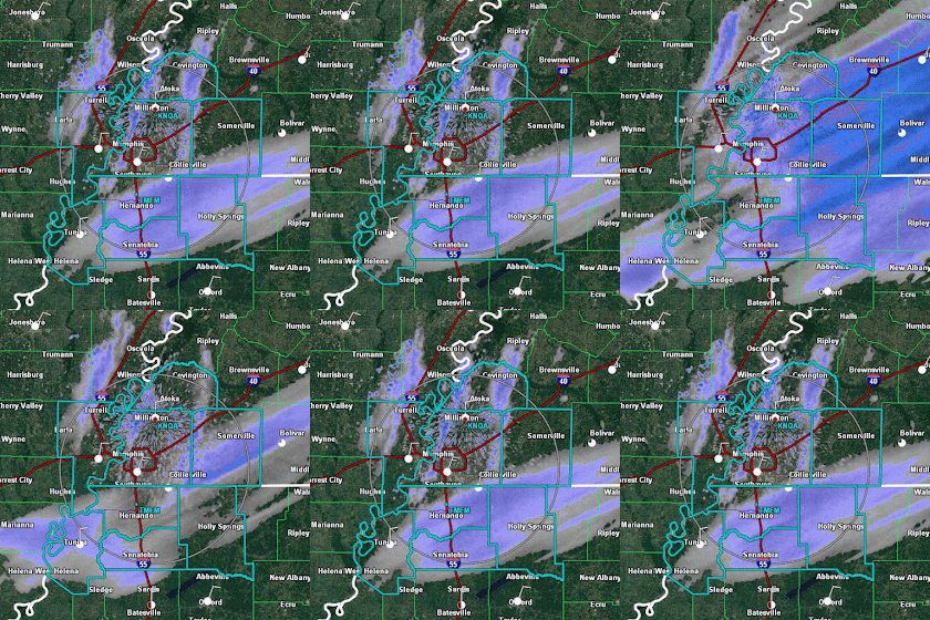
There was very one interesting scenario that developed by mid-morning and continued playing out throughout a good part of the afternoon. Two different "drivers" of light snowfall were occurring at the same time, in the same place. Check out this mid-morning radar loop and see two areas of snow moving in completely different directions:

Radar loop from mid-morning Friday when light snow was moving in two directions - west to east with the main weather system, and north to south as snow bands at lower levels than the primary system. 
And see it still happening several hours later as the late afternoon band of light snow approaches the metro:

Snow moving in multiple directions is still seen at mid-afternoon. The north-south bands of snow continued for several hours on Friday.
There are a couple of possible hypotheses on this strange phenomena, which includes multiple snow bands moving from north to south over the metro and more organized areas of snow moving from west-to-east (which was the snow that was better forecasted and driven by the synoptic setup).

One scenario, and the one I find most plausible at this point, involves the influence that warm water can have on a very cold airmass. It's much like lake-effect snow off the Great Lakes, only at a smaller scale. Cold and fairly dry air moves over that much warmer body of water, picks up moisture from that water, and also starts to rise as it warms a bit from the warm water below (warm air is less dense than cold air and rises). As the wind pushes the air downstream and it begins to cool, the moisture falls from the cooling air, creating a "path" of precipitation in a band that parallels the wind flow. The tell-tale signs are cold air blowing over a fairly substantial body of warmer water and bands of precipitation that are exactly in line with the low level wind.

There were 3 bands that formed in the morning. The first (western band) is believed to be a lake-effect band from Big Lake, which is just west of Blytheville, AR in  Big Lake Wildlife Management Area. The second (center band) is downwind of Open Lake (which is also right next to the Mississippi River) west of Ripley, TN. The easternmost, third, band was a little harder to figure out, but could be traced back to the Mississippi River itself, in an area west of Paducah where the river is fairly straight for several miles and is exactly lined up with yesterday's wind flow. The "fetch" is the amount of warm water the wind traverses. The longer that is, the more moisture it picks up. In this case, the wind was blowing from 020° (or NNE), which lines up with a length of the river that is oriented in the same direction. It's conceivable that we had the perfect scenario for river-enhanced snowfall yesterday! See the map below.

Three morning bands of snow, possibly traced back to their origins if they were indeed lake/river-enhanced snow. The eastern band had a long way to travel from north of Union City, but it likely could have been snowing all along that path from Ripley to Dyersburg to west of Union City. The radar would have been "overshooting" the relatively shallow depth of those precipitation bands that likely only extended a couple thousand feet into the air. 
The second hypothesis, which seemed a little more reasonable as we got farther into the afternoon and the bands became less pronounced, was that the light snow over the metro was due to a cold air miniature version of "convective rolls" which manifest themselves as cloud streets, or lines of cumulus clouds that form parallel to the wind flow. (See the Facebook post embedded above that has the satellite image of snow, then look at the bottom of the picture for cloud streets over the northern Gulf formed by Arctic air blowing over the warm Gulf waters. Another example is below.) If this were the case, in this situation we didn't just have rows of clouds, but clouds that precipitated! Satellite imagery didn't show these clouds like they usually do when typical cloud streets form because the sky was covered in clouds. They would've basically been buried by the other clouds around them. A hidden explanation? Perhaps.

Horizontal convective rolls, or cloud streets, off the U.S. Atlantic coast. Credit Jeff Schmaltz - NASA Earth Observatory.
I don't know exactly what happened, but theorizing and learning with real world experiences is part of why meteorology is so cool. :-)  I hope you enjoy the weekend, even if it is still way too cold. Don't worry, it's Memphis, so you always have this to look forward to:
(If you receive this blog by email and the animations don't work, click here for the online version.)

Erik Proseus
MWN Meteorologist

----
Follow MWN on Facebook, Twitter, and Google+
Visit MemphisWeather.net on the web or m.memphisweather.net on your mobile phone.
Download our iPhone or Android apps, featuring StormWatch+ severe weather alerts!
MWN is a NOAA Weather Ready Nation Ambassador Meteorologist Erik Proseus is an NWA Digital Seal Holder