However, it probably wasn't the ideal snow day for some. Why?
- It was COLD. I know, it has to be cold to get snow, but it was *really* cold. I think many would prefer a "30-degree-no-wind" snow day to a "wind-chills-near-10" snow day. It was hard to stay out for very long.
- The snow quality was sub-par compared to what we're used to. Not only was there not quite enough in the heart of the metro (granted there was more in north MS and up north a bit), but it was too dry to pack. Hard to make snowballs and snowmen with dry snow.
- Though it was drier than we usually get, there was enough on the streets prior to sunrise that when cars did get on it, and weren't going very fast, it just packed it down, which resulted in a thin layer of ice by the afternoon and evening. So it was too cold, too dry of a snow, and hard to drive in.
— Bobby Bellew (@bobbybellew) January 7, 2017
For those keeping score though, it was still a Mid-South snow, and probably more typical of what we should expect than the occasional 3-6" event that we see every few years. MWN on the north side of Bartlett was in a sort of minima with heavier snow north and south. The snow total there was 0.9". The airport on the south side of town officially measured 2" as it got in on a heavier band late in the event between 8-9am that brought totals up to 3" to parts of DeSoto County. Here's the NWS snowfall total map of the event:
Overall, I think the forecasts generally panned out pretty well too. Yes, we all pretty much started with "less than an inch" in some form or fashion on Wednesday and early Thursday, but by Thursday night, most sources had upped that to 1-2". We were on the early side of calling for the increase, and also mentioned that a band would set up that was capable of producing 3" totals, when I posted this in the MWN Blog just before 2pm Thursday:
That "somewhere in the metro" ended up being along and just south of the state line. Model data really caught on to the scenario that played out on Thursday morning and the new high-resolution hourly model data generally did a nice job of pinpointing where that band would set up by very early Friday morning. Kudos to our model developers at the NWS and affiliated research institutions for some fine work being done well-behind the scenes.
 |
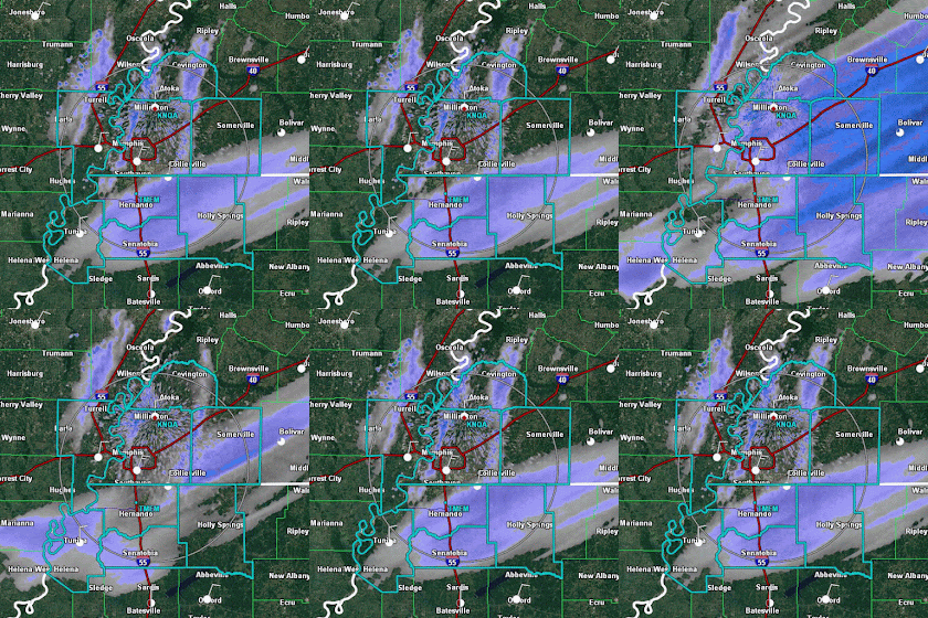
| Radar loop from mid-morning Friday when light snow was moving in two directions - west to east with the main weather system, and north to south as snow bands at lower levels than the primary system. |
 |
| Snow moving in multiple directions is still seen at mid-afternoon. The north-south bands of snow continued for several hours on Friday. |
One scenario, and the one I find most plausible at this point, involves the influence that warm water can have on a very cold airmass. It's much like lake-effect snow off the Great Lakes, only at a smaller scale. Cold and fairly dry air moves over that much warmer body of water, picks up moisture from that water, and also starts to rise as it warms a bit from the warm water below (warm air is less dense than cold air and rises). As the wind pushes the air downstream and it begins to cool, the moisture falls from the cooling air, creating a "path" of precipitation in a band that parallels the wind flow. The tell-tale signs are cold air blowing over a fairly substantial body of warmer water and bands of precipitation that are exactly in line with the low level wind.
There were 3 bands that formed in the morning. The first (western band) is believed to be a lake-effect band from Big Lake, which is just west of Blytheville, AR in Big Lake Wildlife Management Area. The second (center band) is downwind of Open Lake (which is also right next to the Mississippi River) west of Ripley, TN. The easternmost, third, band was a little harder to figure out, but could be traced back to the Mississippi River itself, in an area west of Paducah where the river is fairly straight for several miles and is exactly lined up with yesterday's wind flow. The "fetch" is the amount of warm water the wind traverses. The longer that is, the more moisture it picks up. In this case, the wind was blowing from 020° (or NNE), which lines up with a length of the river that is oriented in the same direction. It's conceivable that we had the perfect scenario for river-enhanced snowfall yesterday! See the map below.
 |
| Horizontal convective rolls, or cloud streets, off the U.S. Atlantic coast. Credit Jeff Schmaltz - NASA Earth Observatory. |
(If you receive this blog by email and the animations don't work, click here for the online version.)If you don't like the weather in Memphis, the European (and all other models) say "stick around"... #memwx pic.twitter.com/rhiSFoy6yk— MemphisWeather.net (@memphisweather1) January 7, 2017
Erik Proseus
MWN Meteorologist
----
Follow MWN on Facebook, Twitter, and Google+
Visit MemphisWeather.net on the web or m.memphisweather.net on your mobile phone.
Download our iPhone or Android apps, featuring StormWatch+ severe weather alerts!
 | |
| MWN is a NOAA Weather Ready Nation Ambassador | Meteorologist Erik Proseus is an NWA Digital Seal Holder |


No comments:
Post a Comment