WOW, that was quite a storm!
Memphis Light Gas and Water reports that, at peak, 188,000 customers were without power at some point after the monstrosity hit on Saturday night, darkening large portions of Shelby County. High wind also affected portions of Tipton and DeSoto Counties.
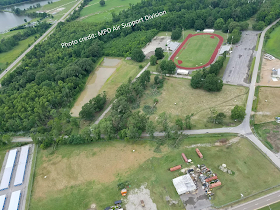
There will be more time to recap the entire event later, but in this post I'd like to focus on one particular area of damage where the highest wind likely occurred. The damage occurred at and around the Memphis Police Department Training Academy near the intersection of Highway 51 and North Watkins in Frayser. This is where the severe storm moving southeast intersected an outflow boundary moving southwest from storms that were occurring north of the metro.
It is typical for colliding outflow boundaries in an unstable airmass to produce new storms. We see it all the time. In this case, when pre-existing storms along one outflow boundary encountered the other outflow, mayhem resulted. What would have been a more "typical" severe wind event became a more rare one when explosive development produced a very strong microburst that landed on the area in question and spread out to the east and south, pushed by storms moving at near highway speeds. It is estimated from these damage photos, particularly the swath of trees that collapsed or were uprooted in the first image below, that wind speeds were near or exceeded 100 mph. This is corroborated by radar data that indicates wind of more than 100 mph just 1000' above ground in the hardest hit areas, which was likely forced to the ground by the microburst near the MPD Training Academy.
Wind that spread out from that area across north Memphis and south into downtown and midtown was likely in the 60-80 mph range. Aerial photo and radar documentation is shown below.
 |
| An aerial shot of part of the MPD Training Academy showing damage to structures and uprooting of large trees. |
 |
| Additional damage from overhead in the area of US 51 and North Watkins. |
 |
| Another view of the same damage shown in the image above. |
 |
| One more photo, taken west of the MPD Academy showing trees uprooted and additional damage. |
The National Weather Service in Memphis has posted this preliminary assessment of the storm:
I'd also like to use this venue to re-post what I wrote on Facebook Sunday night after having a chance to wrap my head around the events of the night before:
It's easy to get frustrated, but the guys and gals at MLGW are working hard on their holiday weekend to try and make your day a little brighter (literally). Personally, I greatly appreciate their hard work and sacrifice, as well as all those in public service who are working extra this weekend, even though I don't have power yet either!
Also, shout-out to all our colleagues in the weather enterprise, from SPC to US National Weather Service Memphis Tennessee to the TV mets and others, who did a phenomenal job leading up to, during, and after "Memphis in Mayhem!"
Finally, I owe a huge debt of gratitude to MWN intern Meteorologist Alex Herbst who covered 95% of last night's event on my, and your, behalf. Between my working weather for 901Fest, racing home to beat the storm, then promptly losing electricity and most cell coverage when it hit, without Alex being on top of things the entire time, this feed would've been largely silent. I and MWN followers alike thank you for your dedicated service, Alex. You have a bright future ahead of you, at much larger endeavors than this one!
Everyone stay safe, be grateful, and thank a utility worker this week! And don't forget it's Memorial Day weekend - take a minute to remember those who paid the ultimate sacrifice so that we can moan and groan over our #FirstWorldProblems!
I appreciate each and every one of you who choose to follow MWN and tell others about this service...Thanks again to all of you who have offered your appreciation for our presence before, during, and after the storm. Those comments keep us going! We'll have a more detailed recap in the days ahead. Be sure to follow us on social media at the links below for regular updates following this storm and updates on current weather in the Memphis area!
Best to you all on this Memorial Day,
Erik Proseus
MWN Meteorologist
----
Follow MWN on Facebook, Twitter, and Google+
Visit MemphisWeather.net on the web or m.memphisweather.net on your mobile phone.
Download our iPhone or Android apps, featuring StormWatch+ severe weather alerts!
 | |
| MWN is a NOAA Weather Ready Nation Ambassador | Meteorologist Erik Proseus is an NWA Digital Seal Holder |


Thanks for all you guys do in explaining what I knew but couldn't explain it the way I just read it.And thanks to MLG&W for all the hard work you guys did to get a lot of us back on
ReplyDeleteI'm very grateful and thank God for you all.
Memphis in May-hem: 105 mph microburst damage in Frayser
ReplyDeleteWOW, that was quite a storm!