One by-product of the stable conditions provided by surface high pressure late this week has been a buildup of ozone at the low levels. While ozone high in the atmosphere is a good thing, near the surface, it means difficulty breathing for those with asthma and other lung-related diseases, as well as the very young and old, and those who do strenuous work outdoors during peak heating hours. The ozone buildup resulted in the Shelby County Health Department issuing a "Code Orange" advisory for Friday and Saturday, indicating that the air was unhealthy to breathe for the sensitive groups listed above. In addition, ozone rose to a high enough level that a "Code Red" advisory (one higher than Code Orange) was issued for a few hours late Friday afternoon and evening, indicating that the ozone levels could cause difficulty breathing for all groups of people. You can monitor air quality status by visiting AirNow.gov or the MWN Air Quality/UV Forecast page.
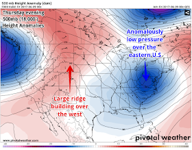
As we head deeper into the weekend, the trough over the east is being replaced by a very strong upper level ridge, which extends south into the Mid-South. This will mean much warmer temperatures (records in fact) for the next few days over the Midwest and into the Northeast, while we start to see warmer temperatures and increasing humidity thanks to high pressure over the southeast U.S. that is bringing more moisture from the Gulf. While the weather remains dry and partly cloudy, southerly wind and the building high aloft will push temperatures into the upper 80s to near 90 this weekend. Sunday in particular will see dewpoints rise well into the 60s, which will make it feel more muggy.
For next week, unfortunately, an unsettled pattern will be in place, promoting daily chances of showers and thunderstorms, particularly in the afternoon and evening when heating is at a maximum. With the high pressure ridge aloft in place to our northeast, surface high pressure over the southeast, and an upper level low over Texas, temperatures will be in the upper 80s to near 90 during the afternoon when scattered showers and thunderstorms are expected and lows will remain above 70 degrees, making for muggy and warm mornings. The pattern looks to let up, if not break, by late in the week to early next weekend when a weak cold front moves into the region. Until then, plan to keep an umbrella handy each day and prepare for downpours where slow-moving cells form. Severe weather threats appear minimal as wind energy and upper level dynamics remains weak.
The MWN app featuring the human-generated Memphis forecast and our social media feeds will keep you on top of the latest on what areas can expect to be affected by storms on a daily basis! Pertinent links can be found below.
Erik Proseus
MWN Meteorologist
----
Follow MWN on Facebook, Twitter, and Google+
Visit MemphisWeather.net on the web or m.memphisweather.net on your mobile phone.
Download our iPhone or Android apps, featuring StormWatch+ severe weather alerts!
 | |
| MWN is a NOAA Weather Ready Nation Ambassador | Meteorologist Erik Proseus is an NWA Digital Seal Holder |


No comments:
Post a Comment