Pages

Tuesday, May 29, 2018

Alberto rains on the Mid-South, then summertime heat returns!

Showers today courtesy of Subtropical Depression Alberto

We have started the day with plenty of cloud cover, helping to keep our temps a few degrees cooler than they have been. Our high today will be around 82°, which is actually a few degrees below average for the end of May - a rarity this month! This cloud coverage is associated with Subtropical Depression Alberto, which is currently located over central Alabama.

Satellite imagery from 10:30 AM shows Subtropical Depression Alberto located over central Alabama giving way to cloud coverage across the southeast. (College of DuPage)
This subtropical system will continue moving northward today, with the center of low pressure moving through Tennessee just to our east. While the center won't move directly over us, it will bring enough moisture for us to see showers and possibly a few thunderstorms later today. Outer bands associated with this storm will reach portions of our area later this afternoon. Alberto will be weak enough that we don't expect any major wind issues as it passes by to our east.

HRRR loop now through late tonight has showers reaching our area this afternoon and scattered showers continuing into the evening. (WeatherBell)
Overnight temps will fall into the low 70s. We could have a few scattered showers remain, but these should begin to move off as we move through the overnight hours.

Wednesday

Tomorrow we will begin to transition back to a somewhat summer-like pattern. High temps will rebound back to 90 with dew point temps coasting near 70°. Scattered clouds will hang around through most of the day, but expect much more sunlight tomorrow than we will see today.

As we move into the afternoon, our shower coverage will begin to increase. Scattered showers and thunderstorms can be expected, with some of us seeing these showers while others will not. Any showers that develop in the afternoon will begin to dissipate when the sun goes down. 
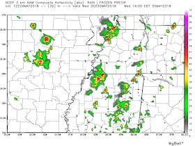
NAM 3km shows scattered showers and thunderstorms across our area tomorrow afternoon. (WeatherBell)


Thursday into the Weekend

By the second half of this week, we will begin to return to our summertime "norm". A somewhat zonal flow at the 500 mb level (a west-to-east wind at 18,000 feet - the level which typically drives our storm systems) will begin to turn into a more ridge-dominate flow. A high pressure system appears to build over Texas, leading to a ridge pattern over the Central U.S. We will be right on the edge of this ridge, which will help influence our overall weather pattern.

GFS 500mb loop from early Thursday through late Sunday night shows a high pressure building in over the Texas area with mid-level ridging across much of the Central U.S. (Pivotal Weather)
So what will this summertime norm look like for the second half of the week? Hot with a slight chance of an afternoon thunderstorm in short.


High temps look to coast in the low to mid 90s Thursday through the weekend with heat index values nearing or just over 100° on some of those days. We will also have plenty of moisture in the air to get that sticky feeling accompanying the above average temps. Dew point temperatures will rise into the low 70s, which will add that uncomfortable sticky feeling.

As for our rain chances, currently carrying everyone's favorite 20% chance Thursday through the weekend. These days will be our typical summertime rain lottery, where some of us will get lucky and steer clear of the showers, where others will have showers develop right on top of them. Luckily, any shower activity should occur primarily in the afternoon and thunderstorm activity will diminish greatly once the sun goes down each night. 

Caroline MacDonald
MWN Meteorologist Intern

----
Follow MWN on Facebook and Twitter for routine updates and the latest info!
Complete MWN Forecast: MemphisWeather.net on the mobile web or via the MWN mobile app
Download our iPhone or Android apps, featuring StormWatch+ severe weather alerts!
MWN is a NOAA Weather Ready Nation Ambassador Meteorologist Erik Proseus is an NWA Digital Seal Holder

Thursday, May 24, 2018

The May pattern continues as we cast our gaze towards the Gulf of Mexico

We really haven't caught much of any break over the past few weeks from the above average temperatures. The record average monthly temperature for May is 76.8° which occurred back in 1962. If May were to end today, we would have the second highest average temperature for the month of May at 76.6°. And for the period May 1-23, this year currently is the warmest on record! While we won't be setting any record high temps in the next few days, temps will still be 5 to 10 degrees above average.

End of the work week

Right now our overall weather pattern has been dominated by a weak mid-level ridge that has been hanging out over our area. This ridge has helped keep those afternoon thunderstorm chances down a bit the past day or two. At the surface, a high pressure system is located in the Ohio River Valley, which has also helped to keep our temps above average and afternoon shower chances to a minimum.
The majority of the Eastern U.S. is dominated by a surface high pressure, which has helped to keep our temps well above average this week. A cold front boundary is located nearly over the metro, but will not affect our temps that much unfortunately. (NOAA/WPC)
Overall, today and tomorrow look to be pretty similar. While mid-level features will try to push the already weak ridge out of our area, the trough following behind will not be strong enough to really impact our overall weather conditions, other than perhaps a few more afternoon showers or thunderstorms.

Taking a look at the 500mb (18,000') level, notice the higher heights (what looks like a hill) located over the eastern U.S. into tonight with some lower heights (a "valley") beginning to move into our area tomorrow. This change in mid-level heights shows a very weak trough moving into our area which will bring some more shower chances tomorrow. (Pivotal Weather)
Highs will stay in the upper 80s to finish up the work week with some scattered afternoon showers/thunderstorm chances each day. Given the location of the stationary boundary, this will help keep some cloud coverage around both days as well.

The holiday weekend

As we move into Memorial Day weekend, the previously mentioned mid-level trough will begin to have more of an impact. Overall, temps look to follow the typical summertime vibes with highs reaching the upper 80s on Saturday and Sunday. Dewpoint temperatures look to be pretty uncomfortable both days as well - near 70 degrees - making for a sticky, sweaty airmass. 


As for rain chances, our afternoon rain chances look to increase slightly both days. Showers and thunderstorms will likely still be scattered in nature, so not everyone will see these showers. Hopefully they will hold off in the AM for those running in the Great American River Run on Saturday. By Saturday afternoon, rain chances will increase a bit, but I wouldn't let that discourage you from going downtown for #901Fest to wrap up Memphis in May. Overall, there is no need to cancel any plans this weekend, but having a good rain plan just in case would be beneficial. 

The GFS model shows scattered showers mainly Saturday and Sunday afternoons around our area. This loop runs from late Friday night through late Sunday night. (Pivotal Weather)


Memorial Day


Yes, there is a developing tropical system in the Gulf of Mexico.

In short, the National Hurricane Center is keeping a very close eye on an area of low pressure currently stationed in the Yucatan Peninsula. This system is expected to become more well-defined in the coming days as it moves into the Gulf of Mexico where warm water awaits. The conditions in the Caribbean Sea, where it is currently located, are favorable for this system to develop into a tropical system. 

The image above displays the chance of tropical cyclone formation within the next five days.  The red bubble indicates the area where there is now a 90% chance of formation within the next five days. (NOAA/NHC)
There is a 70% chance of development within the next 48 hours and a 90% chance of formation in the next 5 days. The system will likely continue to develop in the coming days. While this developing system won't necessarily get to hurricane strength, the main threats will be in the form of copious rainfall for the southeast U.S. and rip currents on the coast, which will likely make the waters at many beaches dangerous.

So what exactly does this mean for us? Two things. 

First of all, we could potentially see some rain from this system in our area sometime next week. There are still enough variables at play that the "how much" and "when" questions can't be answered. We are currently expecting our scattered thunderstorm regime of this weekend to continue into Memorial Day and beyond.

Secondly, schools are getting out for the summer, which means a lot of people have beach trip plans. If you are planning to head to the central or Florida Gulf Coasts this weekend or next week, it would be a good idea to keep up with the National Hurricane Center statements and local National Weather Service offices and local media in the area you are planning to go to. Here are the latest key messages from NHC:


We hope that you all have a safe and enjoyable Memorial Day weekend as summer "unofficially" kicks off (despite it starting May 1 in the atmosphere here in the Mid-South)! Remember that you can take your MemphisWeather.net app with StormWatch+ activated with you on vacation for severe instant weather warnings, no matter where you go in the U.S.! And for local forecasts, radar, and current conditions nationwide, we recommend the free StormWatch+ standalone app for iOS devices. No need to pay for severe weather alerts in that app if you already have them in your MWN app!


Caroline MacDonald
MWN Meteorologist Intern

----
Follow MWN on Facebook and Twitter for routine updates and the latest info!
Complete MWN Forecast: MemphisWeather.net on the mobile web or via the MWN mobile app
Download our iPhone or Android apps, featuring StormWatch+ severe weather alerts!
MWN is a NOAA Weather Ready Nation Ambassador Meteorologist Erik Proseus is an NWA Digital Seal Holder

Saturday, May 12, 2018

April 2018 Climate Data for Memphis, TN

April Climate Recap

April will be remembered as much cooler than average with temperatures over six degrees below the climatological average. In fact, the month featured one sub-freezing morning low (30 degrees on the eighth) and a monthly high of only 80 degrees (just four days after the 30-degree reading in fact)! The overall average temperature ended up third coldest on record for April.

Precipitation was above normal as well, totaling nearly eight inches for the month. Again, heavy precipitation was not uncommon as there were only 9 days with rain but a few heavy rain events, including three with more than an inch and one (the 14th) with three inches of rain. Also due to the cool temperatures, the normal start of severe weather season was delayed as there were no severe reports during the month and only two Severe Thunderstorm Warnings in the metro, on the 3rd and 4th in norther MS.

Memphis International Airport, Memphis, TN


Temperature
Average temperature: 56.3 degrees (6.6 degrees below average)
Average high temperature: 67.0 degrees (6.0 degrees below average)
Average low temperature: 45.7 degrees (7.2 degrees below average)
Warmest temperature: 80 degrees (12th)
Coolest temperature: 30 degrees (8th)
Heating Degrees Days: 266 (129 above average)
Cooling Degree Days: 12 (63 below average)
Records set or tied: The month was the third coolest April on record.
Comments: One day recorded a temperature below freezing (30 degrees on the 8th). The growing season for 2018 commenced on April 9.

Precipitation
Monthly total: 7.86" (2.36" above average)
Days with measurable precipitation: 9
Wettest 24-hour period: 3.02" (14th)
Snowfall: 0.0"
Records set or tied: None
Comments: Three days recorded more than 1.0" and one day saw more than an inch of rain fall.

Miscellaneous
Peak wind: South/43 mph (13th)
Average wind: 9.7 mph
Average relative humidity: 65%
Average sky cover: 50%

Click here for a daily statistical recap for Memphis International Airport.

Cirrus Weather Solutions / MemphisWeather.net, Bartlett, TN


Temperature
Average temperature: 56.1 degrees
Average high temperature: 67.8 degrees
Average low temperature: 43.9 degrees
Warmest temperature: 82.5 degrees (12th)
Coolest temperature: 28.1 degrees (8th)
Comments: None

Precipitation
Monthly total: 7.22" (automated rain gauge), 6.95" (manual CoCoRaHS rain gauge)
Days with measurable precipitation: 8
Wettest date: 2.17" (14th) (via automated gauge)
Snowfall: None
Comments: None

Miscellaneous
Peak wind: South/29 mph (3rd)
Average relative humidity: 70%
Average barometric pressure: 30.04 in. Hg

Click here for a daily statistical recap for Bartlett, TN.

MWN Forecast Accuracy

MWN average temperature error: 2.35 degrees
MWN forecast temperatures within 2 degrees of actual: 62%
MWN average dewpoint error: 3.05 degrees
MWN forecast dewpoints within 2 degrees of actual: 42%

MWN's forecasts extend out five periods (2.5 days, or roughly 60 hours). Historical accuracy statistics can be found here.

----
Follow MWN on Facebook and Twitter for routine updates and the latest info!
Complete MWN Forecast: MemphisWeather.net on the mobile web or via the MWN mobile app
Download our iPhone or Android apps, featuring StormWatch+ severe weather alerts!
MWN is a NOAA Weather Ready Nation Ambassador Meteorologist Erik Proseus is an NWA Digital Seal Holder

Near record breaking temps for now, rain chances return Tuesday

Well, Mother Nature has decided to fast-forward through the rest of spring and propel us straight into summer for the foreseeable future. For this weekend through next, temps look to stay around 10 degrees above normal for mid-May.


Our weather pattern will continue to be dominated by an upper-level high pressure ridge over our area into the beginning of next week. Following this ridging pattern to the surface is a nice high pressure, keeping our skies filled with plenty of sunshine helping keep away any of those pesky afternoon showers for now.

Mid-morning Saturday surface analysis showing the high pressure built over the majority of the southeastern U.S. (NOAA/WPC)
Along with these well-above average temperatures, we will get close to a few record highs. Highs today through Monday look to stay in the low 90s with overnight temps dipping into the low 70s. To put these temps in perspective, the record high for today is 93°, tomorrow is 95°, and Monday is 91°. I would not be surprised to see that record broken on Monday.

Tuesday Forward

Tuesday into the second half of the week expect temps to stay above average with increasing mugginess. We could break a few more high temperature records on Tuesday and Wednesday, with forecast highs near and/or exceeding the current record for both days (91 and 92 degrees, respectively). As we stand currently, we could break more than one record between now and Wednesday. 


By Thursday, our temps will finally begin to back off a bit with highs in the mid to upper 80s. It'll still be hot, but not as hot as it has been.

12Z GFS loop of forecast precipitation from midday Tuesday through Saturday night showing scattered showers across much of our area. (Tropical Tidbits)

Two low pressure systems arrive towards the middle of next week and will re-introduce some rain chances. We will have a subtropical low system coming at us from the Gulf of Mexico, providing ample amounts of moisture and aiding in our rain chances through the second half of the week. The second system will pass by to our north, but will help to bring temps down a few degrees Thursday into the weekend. Shower chances begin on Tuesday and will continue each day into the weekend. For those planning to head to the Memphis in May World Championship Barbecue Cooling Contest Wednesday through Saturday, you may want to bring your small umbrellas (oversized ones not allowed), poncho and rain boots with you each day. 

I wouldn't let these rain chances hinder any plans you may have, but you might go ahead and have a good afternoon/evening rain plan just in case

A Glimpse into Next Weekend

Next weekend looks to be a lot like the second half of the week; mild temperatures, partly to mostly sunny skies, and daily afternoon scattered rain chances.

Climate Prediction Center's 6 to 10 Day Outlook valid May 17-21 shows a high likelihood of above average temperatures over our area. (NOAA/CPC)

Caroline MacDonald
MWN Meteorologist Intern

----
Follow MWN on Facebook and Twitter for routine updates and the latest info!
Complete MWN Forecast: MemphisWeather.net on the mobile web or via the MWN mobile app
Download our iPhone or Android apps, featuring StormWatch+ severe weather alerts!
MWN is a NOAA Weather Ready Nation Ambassador Meteorologist Erik Proseus is an NWA Digital Seal Holder

Tuesday, May 8, 2018

Hope you enjoyed spring! Summer conditions are upon us...

Following the third coolest April on record (which ended up just a touch warmer than March overall), it seems that the calendar flip to May also caused the thermometer to jump quite a bit. And we're still climbing! The highest temperature in the month of April was only 80° and we just reached that point just once. With the exception of this past Friday and Saturday, we've been into the 80s each day this month.

A string of consecutive days with highs in the mid 80s started on Sunday and doesn't look to end for at least a week as the numbers continue to slowly climb towards 90°. Projecting the forecast temperatures out over the next week and comparing to historical data, the first half of May could end up being close to the top 5 warmest starts to May on record! Say goodbye to those low utility bills from April!


A weak front will push a little closer to the region from the north over the next 48 hours, resulting in small rain and thunderstorm chances, mainly to our north. There will be enough sunshine between the clouds to keep the mid 80s temperatures around though as southerly wind continues. Don't be completely surprised though if a stray shower or thunderstorm occurs, mainly on Wednesday.

Later in the week, high pressure builds back over the region and pushes the storm track well to our north again. This pattern is somewhat similar to summer in the Mid-South, with the exception being humidity levels, which won't be quite to those mid-summer levels just yet. Thank goodness! Starting Friday, mostly sunny skies are expected through the weekend with highs reaching 90° and lows rising into the upper 60s to near 70°. This will likely be just our SECOND completely dry weekend of 2018 after the beautiful one we had two weekends ago to end the month of April.

Mid-level pressure pattern (500 mb, or 18,000') on Saturday evening with the primary storm track to our north (where the wind is stronger in the blues/pinks) and a ridge of higher pressure to the south. (PivotalWx)
By early next week, storm chances increase as the high weakens a bit, allowing the storm track to dip back south again. Increased cloudiness will likely put the lid on temps just a bit, bit we could be exchanging it for increased humidity. Thus, it'll still feel very warm out, only it will be more because of the humidity in the air. Hang on! Summer's getting a bit of a jump start!

Erik Proseus
MWN Meteorologist

----
Follow MWN on Facebook and Twitter for routine updates and the latest info!
Complete MWN Forecast: MemphisWeather.net on the mobile web or via the MWN mobile app
Download our iPhone or Android apps, featuring StormWatch+ severe weather alerts!
MWN is a NOAA Weather Ready Nation Ambassador Meteorologist Erik Proseus is an NWA Digital Seal Holder

Transition on #TeamMWN

It's the time of year when college students graduate and move on to the their chosen profession or graduate school. As you know, MemphisWeather.net relies a great deal on student interns that are studying meteorology at the college level to help bring you always-current weather content. So, this time of year can be bittersweet as I bid farewell to some and welcome others into the #TeamMWN fold!

Signing off

Alex Herbst has been an MWN intern since January 2017 as he has pursued his Master's Degree in Broadcast Meteorology at Mississippi State University. He graduated last week and is now off to pursue his dream job in a big market! I have nothing but great things to say about Alex. He has been focused on and dedicated to serving all of you, and has also been a good friend to me. He has written many a blog post, filled in occasionally on the forecast desk, and authored hundreds of tweets (at least)! He even flew solo on MWN when the Tom Lee Storm blew through last May while I was stranded in darkness with no internet! Being from the NYC area, I know he hopes to someday land an on-air gig in his hometown, and I have no doubt that that will happen. Alex knows his meteorology, he knows how to communicate it, and he is passionate about his chosen profession. Alex, we wish you well! And anytime you want to come back and pen a blog or work an overnight storm system in the Mid-South, the floor is yours! :-)

Here are some comments from Alex, in his own words:
One and a half years, and what a ride it has been. From the Memorial Day 2017 severe storms to the spin up tornadoes after Hurricane Harvey to all those quiet sunny days like today, it has been my honor and privilege to serve as part of Team MWN and bring you consistent, accurate, and timely weather information for the Memphis area. We have shared in many great moments, and many challenging ones, but MWN has been there to help guide us all through the storms, and will continue to be there for years to come.
I want to extend a sincere thank you to Erik Proseus, who brought me on board back in January 2017 and trusted me to help serve you all with the best forecasts and weather information in the mid-south region. He has been such a great person to work for and work with, continuing to improve my craft as a communicator and a meteorologist. He is a tireless advocate for his team, but he deserves so much of the credit on a daily basis for the successes of MemphisWeather.Net.
I also want to thank all of the interns that I have worked with over my time at MWN. Lauren Pounds, Adam Sabes, Trevor Birchett, Reggie Roakes, and Caroline MacDonald helped me grow and learn the ropes here at MWN, and many of them will continue to carry our brand forward. Lauren, Reggie, and Caroline will continue to be great ambassadors for MemphisWeather.Net and provide the great weather knowledge (and occasional memes and GIFs) that you all have come to know and love.
MemphisWeather.Net is in great hands going forward, and I am excited to watch and listen with all of you as they continue to provide all the weather you’ve come to rely on over the years. I hope to be able to share my future plans in the coming weeks. But for now, this is Meteorologist Alex Herbst signing off for the final time from MWN.

Moving forward!

Though she started a couple of weeks ago, I'll make this the formal introduction of Caroline MacDonald, who will be filling Alex's big shoes! Caroline also graduated from Mississippi State last week with her Bachelor's in Meteorology, but is starting graduate school at #HailState this fall. She resides in middle TN and interned with @NashSevereWx for the past 2 years, which means she knows her stuff - and is even fluent in GIF-ology! Caroline comes with the highest of recommendations and we look forward to having her as part of #TeamMWN! She will work social media, write blog posts, and also occasionally pick up some forecasting duties. Welcome aboard Caroline!

Fortunately, some things don't change, so our consistency going forward will be provided by rising Senior, Lauren Pounds, and brand-new graduate student, Reggie Roakes. Both are enrolled in Meteorology at Mississippi State (at some point, I may just need to go ahead and get a cowbell for the home office!). Reggie also just received his undergrad degree and starts a Master's program this fall. He has quickly come up to speed this spring since starting over Christmas break and brings his own unique perspective to the team! I know that will come out even more as begins blogging for MWN. Reggie will continue to be responsible for keeping social media updated in good weather and bad, and will also be writing periodic forecasts as well.

And though she is the youngest, Lauren has just a year of meteorology classes left and has proven to be a huge asset to us on the social media nowcasting side. As she gets into her forecasting classes this next year, I'll let her take the wheel more and start practicing her developing forecast skills on you all! Lauren hails from New Orleans and has stories to tell about surviving Hurricane Katrina, so there's no doubt where her passion lies. I look forward to the great content that Caroline, Reggie, and Lauren all bring to you all in the coming months!

#TeamMWN, summer 2018 - (L to R) Erik, Reggie, Lauren, and Caroline
Erik Proseus
MWN Meteorologist

----
Follow MWN on Facebook and Twitter for routine updates and the latest info!
Complete MWN Forecast: MemphisWeather.net on the mobile web or via the MWN mobile app
Download our iPhone or Android apps, featuring StormWatch+ severe weather alerts!
MWN is a NOAA Weather Ready Nation Ambassador Meteorologist Erik Proseus is an NWA Digital Seal Holder