The big story for today and tomorrow will be our Heat Index values. Our local NWS has placed all of our area under a Heat Advisory since most of us will experience heat index values in the 105 to 110 range in the afternoons and early evenings. Be sure to stay cool and hydrate over the next few days. Limiting long term exposure and taking breaks will help given these temperatures.
Today
Latest observations show that we have already reached the 90 degree mark for today. Taking a look at the current satellite imagery, we appear to be under a nice bubble of clear skies, which will allow our temps to continue warming into the afternoon.
 |
| Visible satellite imagery loops shows clouds to our east and more clouds funneling down the Mississippi River. (College of DuPage) |
You may notice some clouds to our north that are generally moving our direction. This may provide some relief this afternoon from our warm temps, but may also introduce some shower and thunderstorm activity. With any thunderstorms that develop, there is the possibility that some may become severe. For this reason, we are included in a Marginal Risk from the Storm Prediction Center.
 |
| The Storm Prediction Center includes some of our counties in a Marginal Risk for severe weather while placing other counties in general thunderstorm outlook. (NOAA/SPC) |
Truthfully, showers/thunderstorms are a possibility, but any that develop should remain fairly isolated. I would not let this small chance discourage you from participating in any fun, outdoor activities today like the Patriotic Pops. We will be keeping an eye on things for you if showers develop, but overall the biggest concern for today is the heat, so stay cool out there!
Into the evening hours tonight, things will stay fairly warm. The sky should remain mostly clear, which is good news for all of those heading out to see the Patriotic Pops. Overnight temps will only fall into the upper 70s, so not expecting much temperature relief.
Friday
Tomorrow appears to be a cut and paste copy of today, with highs reaching around 97. Precipitation chances will remain isolated for the area under a partly cloudy sky. Heat index values will be in the 105 to 110 range again.
This weekend into the beginning of next week
By this weekend, it will still be hot, but temps do appear to back off a degree or two. Highs will be in the mid 90s and with dew points still coasting in the 70s will allow heat index values to be near 100.
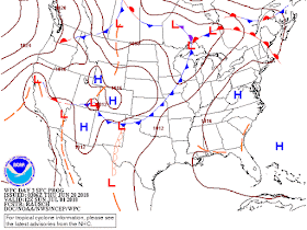
The good news for the weekend is that a high pressure system will continue to build into the eastern half of the U.S., which should keep afternoon showers and thunderstorms fairly isolated.
 |
| A high pressure system centered over the eastern half of the U.S. will dominate our weather pattern over the weekend. (NOAA/WPC) |
A quick look at 4th of July festivities on Tuesday and Wednesday
Taking a look into the middle of next week, things actually appear to be setting up nicely for the fourth of July holiday. We still appear to be under a high pressure by then, but temps do look like they may back down a bit by Wednesday. It will still be hot with highs in the 90s over the two days, but highs will probably stay in the low 90s compared to the upper 90s we've seen recently. This sets up for some pretty nice BBQ weather if you ask me.
As for our overnight temps, our lows appear to stay in the mid 70s. This will provide a little relief from the daytime heat, but still pretty warm for any firework viewing Tuesday and Wednesday.
Really the big question I'm sure many of you have is this: is it going to rain? Well, just like any good, summertime forecast, it is a bit complicated. Given the overall set-up, it does not appear like the third or fourth of July will have any kind of washout, which is good. Right now our medium-range models do vary in terms of precipitation though. The GFS wants to bring some scattered showers and thunderstorms on Tuesday, while the Euro keeps us dry. For the fourth, the GFS has some showers and thunderstorms in the area during the day, but has us fairly dry by the evening. With all of this in mind, and the weather set-up, I do think it is possible to have some scattered afternoon showers and thunderstorms. Luckily, these will likely be driven by daytime heating, so once the sun goes down, any thunderstorm that develops should quickly die out, which would leave clear and perfect viewing conditions for any evening firework displays!
MWN Meteorologist Intern
----
Follow MWN on Facebook and Twitter for routine updates and the latest info!
Complete MWN Forecast: MemphisWeather.net on the mobile web or via the MWN mobile app
Download our iPhone or Android apps, featuring StormWatch+ severe weather alerts!
 |  |
| MWN is a NOAA Weather Ready Nation Ambassador | Meteorologist Erik Proseus is an NWA Digital Seal Holder |


No comments:
Post a Comment