Pages

Friday, August 31, 2018

Fantastic Labor Day weekend, then we geek out on next week's forecast

A busy weekend is coming up for a lot of us with plenty of people wanting to take advantage of the long, holiday weekend. Luckily, Mother Nature has provided us with some pretty good weather for the weekend - it may even feel a little summer-like still.

Today

Happy Friday everyone! Things appear to be somewhat similar today to yesterday's conditions with highs near 90 and a chance of showers and thunderstorms. The good news is that storm coverage this afternoon/evening shouldn't be as high as it was yesterday. Some high resolution models show this scattered nature of storms later today.
HRRR model of simulated reflectivity from now through late tonight shows scattered showers and thunderstorms developing across the Mid-South primarily in the afternoon to early evening hours. (WeatherBell)
Any showers and thunderstorms that develop this afternoon should begin to lose strength shortly after sunset. Temps will remain in the 80s through the evening hours for all of those with plans to head out to high school football games.

Labor Day Weekend

For all of those with plans to take advantage of the long weekend, you are in luck! Besides some slight afternoon shower chances, the majority of the day should be filled with plenty of sunshine. Highs will remain in the low 90s, but a nice breeze each day could help.


If you will be out tailgating on Saturday for the Memphis Tigers season opening football game, you'll definitely want to have plenty of water and sunscreen! Recall the UCLA game last year? Yeah, it was hot... Same goes for the USL soccer exhibition at AutoZone Park on Saturday.

Sunday will likely be the warmest day of the weekend with heat index values nearing 100. If you do plan to be outside for prolonged periods of time, be sure to stay hydrated. 

Tuesday through next week

In short, next week will be pretty boring with highs in the lower 90s, lows in the lower to mid 70s, and minimal rain chances each day. For those of you that want a quick forecast, there it is. For those of you interested in learning why this is happening, let's get geeky - read on!


First things first, high pressure influences will be our friend next week. The map shown below represents mid-level flow (about 18,000 feet up in our atmosphere) averaged over a 5-day period from Sunday-Thursday. The average pressure pattern is shown by the solid black lines with a large high pressure system over the eastern U.S. Warmer colors, such as orange and yellow, mean a positive pressure anomaly (above normal pressure) whereas the cooler colors, such as blue, mean a negative pressure anomaly (below normal presure).


I know, it's a bit complicated. Essentially, areas with these "warm colors" means that average heights will be higher than normal through the period, which is correlated with high pressure. As you can see, these higher height anomalies are set up over the eastern half of the U.S., with our area feeling these influences.
European 5-day ensemble mean shows higher heights over the eastern half of the U.S. designated by the warmer colors. (WeatherBell)
So how does this translate to what we will see? For us, high pressure usually means near to above average temperatures depending on the set-up and rain chances kept to a minimum. Taking a look at a few additional resources, we see that this is the case. An NWS ensemble (basically a combination of a bunch of individual models) forecast shows highs near 90 or a bit higher, which is a touch above average, and overnight lows in the low to mid 70s, which is also a bit above average. 

NWS Blend of Models for next week shows temps a little above average for the first half of the week, with temps cooling to right around average for the second half of next week. (weathermodels.com)

Additionally, precipitation chances will be kept to a minimum next week. One of our medium-range models, the ECMWF,  shows very little precipitation occurring around the Memphis region through next week. The only exception appears to be isolated chances of afternoon thunderstorms like you might expect in a hot summer airmass. 
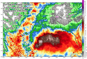
00Z European Model shows very little total precipitation around the Mid-South region with much more precipitation occurring along the Gulf Coast. (WeatherBell)
So while it may be a semi-boring weather pattern next week, there is actually a lot going on in the atmosphere to cause this!


For the complete forecast, be sure to visit the MWN app or our website. Links are provided below.

Caroline MacDonald
MWN Meteorologist Intern

----
Follow MWN on Facebook and Twitter for routine updates and the latest info!
Complete MWN Forecast: MemphisWeather.net on the mobile web or via the MWN mobile app
Download our iPhone or Android apps, featuring StormWatch+ severe weather alerts!
MWN is a NOAA Weather Ready Nation Ambassador Meteorologist Erik Proseus is an NWA Digital Seal Holder

Tuesday, August 21, 2018

Summer Takes A Hike, Briefly

We've got some cooler weather in this forecast, along with a dry spell. This pattern will certainly give the Mid-South an early fall taste that many will enjoy, before temperatures start to return to a summer style this coming weekend.

Summer is taking a hike for the next few days, giving a taste of fall-like weather for the Mid-South

Tuesday and Tuesday Night


Thanks to yesterday's cold front that brought a decent amount of storms through the Mid-South, temperatures today will be pleasantly cool. In the wake of the front, moisture wrapping around low pressure to our north will help with the production of clouds that should help limit the amount of sunshine we get, so temperatures for this afternoon are forecasted to only top off around 83 with humidity in the "tolerable" range.


Tuesday night, skies clear out meaning that there will be a combo of both less humid air and no clouds to hold in heat, equaling a crisp, fall-ish night/morning for Wednesday. Temperatures dip into the upper 60s for the city, but rural areas could be cooler in the mid 60s.


Wednesday Through Friday Night


Wednesday through Friday, the forecast remains dry as a high pressure system gradually traverses from the plains, to the Ohio Valley, and eventually for the weekend moving to the Atlantic coast. Until it reaches the coast, that high will help keep flow from the north/northeast, keeping cooler/less humid air in place. Look for highs to be in the mid 80s for Wednesday and Thursday, eventually climbing back to near 90 for Friday. Nighttime conditions, likewise, remain cooler with less moisture in the air: lows will be in the mid to upper 60s each night. Skies Wednesday could still see a few clouds, but Thursday and Friday will both see a good amount of sunshine.


The Weekend


All good things must come to an end, and that is the case for the weekend. Flow starts to return from the south starting Saturday. That means we will start to see our humidity slowly start to climb back up, along with our lows creeping back into the 70s. Saturday remains dry with a high in the lower 90s when our humidity first starts to increase. Skies remain partly cloudy through the day and into Saturday night when temperatures only drop to the low 70s.

Humidity continues to increase for Sunday, providing enough moisture to work with day-time heating and provide the chance of an isolated shower in the afternoon. Despite a high only in the low 90s, heat indices by this point will be back near the triple figures. Skies remain party cloudy. Sunday night, look for lows to return back to the routine: mid 70s


Next Work Week


The start of next work week will be very similar to Sunday's forecast. Look for humid conditions to remain, meaning summer is back and in full swing. Temps in the afternoons top in the lower 90s as heat indices approach the triple figures. Skies remain partly cloudy with the opportunity of a select few catching an isolated shower while most remain dry. At night, plan on a few clouds hanging around as temps struggle to drop with lows each night only in the mid 70s.

Reggie Roakes
MWN Meteorologist

----
Follow MWN on Facebook and Twitter for routine updates and the latest info!
Complete MWN Forecast: MemphisWeather.net on the mobile web or via the MWN mobile app
Download our iPhone or Android apps, featuring StormWatch+ severe weather alerts!
MWN is a NOAA Weather Ready Nation Ambassador Meteorologist Erik Proseus is an NWA Digital Seal Holder

Saturday, August 18, 2018

Storms possible through Monday night, then a taste of fall?

We've had a pretty interesting weather pattern here in Memphis over the past week. We've had days with above average temps and days with below average temps. Some areas have stayed pretty wet, while a lot of the metro area hasn't seen a drop recently. Luckily, cooler temps do look like they will be hanging around for the next few weeks. Along with that, uncertain rain chances will continue this weekend into the beginning of next week. However, by the middle of next week we will begin to see a pattern shift. If we can just make it until then, I bet you'll all like the rewards that Mother Nature is about to bring.

Today

Do you remember yesterday? Well, today appears to be very similar to what we experienced then. Highs will top off around 88 this afternoon with intermittent cloud coverage throughout the day. Dewpoint temperatures will coast in the 70s, leaving us with some pretty sticky conditions.


As for rain chances, most of us will probably stay dry today, but a shower or two cannot be ruled out. Overall we are expecting for the majority of the showers/thunderstorms to stay to the south of the metro area, but a scattered shower could creep towards us this afternoon into this evening as a weak cold front inches into the area and stalls.

HRRR radar loop now through 2 AM shows scattered thunderstorms primarily in northern MS with maybe a few showers closer to the metro area this afternoon. (WeatherBell)

Sunday

Another hot and humid day appears likely on Sunday as the front retreats to the north. Cloud coverage will continue to hang around, but temps will reach near 90 for our high. Dewpoint temps look to remain in the 70s, so expect mugginess to hang around. As for our rain chances, it appears that the majority of us will stay dry through a good portion of the day with the best scattered thunderstorm chances coming in the evening into the overnight hours as low pressure begins to crank up to our northwest. Things will stay pretty muggy overnight with temps only falling to 75.

Monday

I spy a pattern shift coming on Tuesday, but first we have to make it through a potentially soggy Monday. As a low pressure system develops north of the Ohio River Valley, a frontal system will be set up across the Mid-South, likely bringing some showers and thunderstorms. 

Weather Prediction Center's Day 3 surface map shows a low pressure system moving into Michigan with an associated cold front moving through the Ohio River Valley and down into the Mid-South early on Tuesday. (NOAA/WPC)
While we are not expecting a complete washout, we could see a few strong to severe thunderstorms on Monday. Showers and thunderstorms appear possible throughout the day, but any strong storms that develop would likely do so in the afternoon to evening hours and could pose a damaging wind or hail risk.

The Storm Prediction Center currently has us in a Marginal Risk (level 1/5) on Monday. (NOAA/SPC)
Highs will be near 88 on Monday with 10 to 15 mph winds possible throughout the day. We will continue to keep an eye on the timing of these showers and thunderstorms for Monday.

Tuesday through the rest of the work week

After all of the rain chances and sticky humidity levels we've had recently, the second half of next week looks amazing. Thanks to a cold front passing through early on Tuesday, rain chances will back off to nearly non-existent and things will dry out. Temps will remain below average with dewpoints falling back into the 60s, and maybe even the 50s!

The NWS forecast temperatures for the next week shows highs dropping back into the mid 80s with morning lows into the mid 60s by the middle of next week! (WeatherModels.com)

It may not feel quite like fall, but it will definitely be nice to catch a break from those high humidity values. Plus a few nights next week will save us some dollars on our cooling bills!


Looking into the future

The best news of all to share is that below average temps may be here to stay for the foreseeable future. The last week of August and both of the first two weeks in September appear to feature below average temps.


Caroline MacDonald
MWN Meteorologist Intern

----
Follow MWN on Facebook and Twitter for routine updates and the latest info!
Complete MWN Forecast: MemphisWeather.net on the mobile web or via the MWN mobile app
Download our iPhone or Android apps, featuring StormWatch+ severe weather alerts!
MWN is a NOAA Weather Ready Nation Ambassador Meteorologist Erik Proseus is an NWA Digital Seal Holder

Friday, August 10, 2018

Warmer weather returns; low rain chances persist

Rain output from the recent stalled front under-performed the past few days. Don't worry rain wanters; we have more shots at showers and storms over the next several days, after today.


Today and Tonight


With that stalled front moving out of here, our skies will be clearing out today. With the return of sunshine, temps will be back on the rise, topping off around 90. As we move into the afternoon, some leftover energy from the exiting front, combined with today's heat, could produce a few isolated storms that last into the early evening; however, most will be remaining dry. Tonight, any storms that could develop will end early on and skies finish clearing out. Despite the clear skies, temps tonight only drop to 72. Sorry, no 60s.


Saturday and Saturday Night


If you're wanting to pull off some outdoor activities this weekend absolutely rain free, Saturday morning is going to be your best bet. Clouds gradually trickle in throughout the day and a very weak front starts to dive southeast. Unfortunately, clouds won't move in fast enough to prevent heating, bringing highs to the mid 90s for the afternoon. The inbound front will bring the chance of a few storms mid-late Saturday afternoon. These could last into the evening, and possibly into the early night if enough instability hangs around after sunset. After any remaining isolated storms move out, skies turn clear and temps drop to a low around 74.

NAM 12km model at 7pm Saturday shows a few storms moving through the Mid-South along a weak front. Source-Tropical Tidbits.

Sunday and Sunday Night


That weak front that dives south later Saturday will stall out near Memphis, bringing a source to help give some lift for Sunday afternoon storms. So, Sunday will start dry and mostly sunny. As we head into the afternoon, sky conditions turn partly cloudy and we will watch for scattered storms to develop. Obviously by this point in the forecast, summer has returned with yet another day with temps in the 90s.
Summer heat makes it's return by the weekend and looks to mainly stick around for the next several days

Sunday night, a few storms could be hanging around early on. They will gradually weaken after sunset, bringing back mostly clear skies for the remainder of the night. Temps Sunday night drop to the lower 70s.


Monday and Tuesday


Monday, the weak, stalled front remains over Memphis, providing enough lift for another dose of isolated storms in the afternoon. Temps will again top off around 90, with partly cloudy skies trying their best to hold off the heat. Monday night, rain chances linger on early, before ending and skies turn mostly clear. Lows in the lower 70s.

Tuesday, high pressure ridging temporarily takes over, breaking down that weak, stalled front. Skies will be partly cloudy, with obviously some sun coming in. There is the chance for an isolated shower or storm in the afternoon; however, anything that develops will be purely instability driven thanks to temps warming into the low 90s. Tuesday night, skies will be mostly clear and temps drop to the mid 70s.


Wednesday through Friday


Wednesday through Friday all look to be similar temperature-wise at the moment with highs topping off in the 90s and nighttime lows in the mid 70s. Wednesday will be similar to Tuesday rain-chance-wise with just another shot at just an isolated shower or storm possible. Thursday and Friday, another front dives south and stalls out across the Mid-South, bringing a new shot at increased rain chances. As a disclaimer, rain chances do increase, but they will remain scattered, so its likely that not everyone will see rain both days and it will not last all day.

Reggie Roakes
MWN Meteorologist

----
Follow MWN on Facebook and Twitter for routine updates and the latest info!
Complete MWN Forecast: MemphisWeather.net on the mobile web or via the MWN mobile app
Download our iPhone or Android apps, featuring StormWatch+ severe weather alerts!
MWN is a NOAA Weather Ready Nation Ambassador Meteorologist Erik Proseus is an NWA Digital Seal Holder

Tuesday, August 7, 2018

July 2018 Climate Data for Memphis, TN

July Climate Recap

The month of July ended slightly above normal in the temperature category, but by less than a half degree. While the first three weeks of the month featured only 2 days below normal (and both by a mere degree), a cool spell to end the month helped bring the average down. There were no above average days in the final 10 days of July as a pleasant patter set in, allowing morning lows to reach 70 degrees or cooler on five occasions. No daily records were set during the month. Scattered thunderstorms during the month again resulted in varying rainfall totals. While the airport ended the month above average with exactly five inches of rain, MWN in Bartlett recorded about 3/4 of an inch less. Most rain at the airport fell on only 5 days, leaving large periods of dry weather between.

Severe weather reports for the month included trees down and wind damage from scattered storms in Shelby County on the 4th, 5th, 14th, and 15th. Also, wind damage and hail occurred in Shelby and DeSoto Counties on the 20th, and a very unfortunate fatality occurred on the 14th in Fayette County, in which lightning struck a tree that subsequently fell on an individual mowing his yard. There were also a couple of reports of wind damage in north MS on the 4th and 20th. There were multiple Severe Thunderstorm and Flash Flood Warnings issued for the greater Memphis metro over the course of the month.

Memphis International Airport, Memphis, TN


Temperature
Average temperature: 83.0 degrees (0.3 degrees above average)
Average high temperature: 92.0 degrees (0.4 degrees above  average)
Average low temperature: 74.1 degrees (0.3 degrees above average)
Warmest temperature: 97 degrees (5th, 11th, 13th)
Coolest temperature: 68 degrees (31st)
Heating Degrees Days: 0 (0 below average)
Cooling Degree Days: 567  (18 above average)
Records set or tied: None.
Comments: Twenty-four days recorded high temperatures at or above 90 degrees, which is 3.1 days above average.

Precipitation
Monthly total: 5.00" (0.41" above average)
Days with measurable precipitation: 8 (0.8 days below average)
Wettest 24-hour period: 2.01" (18th)
Snowfall: 0.0"
Records set or tied: None
Comments: Two days recorded more than 1.0" of rain.

Miscellaneous
Peak wind: Northeast/35 mph (15th)
Average wind: 6.2 mph
Average relative humidity: 70%
Average sky cover: 50%

Click here for a daily statistical recap for Memphis International Airport.

Cirrus Weather Solutions / MemphisWeather.net, Bartlett, TN


Temperature
Average temperature: 81.1 degrees
Average high temperature: 91.8 degrees
Average low temperature: 72.1 degrees
Warmest temperature: 97.1 degrees (15th)
Coolest temperature: 65.4 degrees (24th)
Comments: Temperature data was computed for 30 of the 31 days in July. Data was not available due to an equipment outage on the 17th.

Precipitation
Monthly total: 3.94" (automated rain gauge), 4.30" (manual CoCoRaHS rain gauge)
Days with measurable precipitation: 8
Wettest date: 2.03" (16th) (via automated gauge)
Snowfall: None
Comments: None

Miscellaneous
Peak wind: East/30mph (16th)
Average relative humidity: 81%
Average barometric pressure: 30.01 in. Hg

Click here for a daily statistical recap for Bartlett, TN.

MWN Forecast Accuracy

MWN average temperature error: 1.51 degrees
MWN forecast temperatures within 2 degrees of actual: 81%
MWN average dewpoint error: 1.76 degrees
MWN forecast dewpoints within 2 degrees of actual: 75%

MWN's forecasts extend out five periods (2.5 days, or roughly 60 hours). Historical accuracy statistics can be found here.

----
Follow MWN on Facebook and Twitter for routine updates and the latest info!
Complete MWN Forecast: MemphisWeather.net on the mobile web or via the MWN mobile app
Download our iPhone or Android apps, featuring StormWatch+ severe weather alerts!
MWN is a NOAA Weather Ready Nation Ambassador Meteorologist Erik Proseus is an NWA Digital Seal Holder

Monday, August 6, 2018

Summer plays on, but some relief is in sight

Today is the first that many make their return to school. Despite the return to school, summer keeps trucking for the Mid-South for the next week. However, it looks like we may have some relief in the forecast. Like most good things, a cool down will come at a bit of a cost - rain (though with drought conditions developing, some may appreciate the chance for some of it).

Today (Monday)

A similar forecast to what we saw yesterday: HOT! High pressure remains locked in the Mid-South allowing for temperatures to swell to 93. Now that isn't always so bad, but with the humidity now back in full force, especially compared to last week, temperatures are feeling much warmer, near 100. If you jump over the river into Arkansas, heat indices will be even higher near 105, bringing a warranted Heat Advisory that will last until 7pm. With how warm things will be, there will be a lot of instability as we head into the afternoon. Just like yesterday, we will have to watch for any isolated pop-up showers and storms, which if they get to fully develop, could bringing some serious localized rain and a lot of lightning.

Moving into tonight, look for mainly clear skies and mild nighttime conditions. With the amount of moisture in the air at night now, temps do not cool as efficiently as they were last week, so we will see our low dipping only to 76 (sorry, no crisp feeling 60s).

Tuesday

Tuesday, at least during the day, will seem similar to yesterday and today, with yet another repeat and hot weather. Look for another high of 93, partly cloudy skies, and another shot at afternoon storms driven by the afternoon heat. The bigger change will come later in the evening, into Tuesday night. A low in the Ohio Valley will spark a front that will be diving south. The forcing from this front, combined with the warm, moist environment present in the Mid-South, will lead to organized showers and storm activity during the night. The current thinking on the timing for this will be after midnight, Tuesday night. Increasing clouds Tuesday night with the inbound front will continue to hold temperatures overnight in the mid 70s.

Wednesday

The front that comes in Tuesday night stalls out over the Memphis area Wednesday. This is going to lead to an increased chance of rain throughout the day. Overall, we will likely see a fair amount of showers and storms for Wednesday (which should bring some mixed feelings since some are really needing this rain to help alleviate the developing drought conditions, while others may not want the rain). That said, some could make it through this will little to no rain, while others get a fair amount. The good news for everyone: COOLER WEATHER! Increased cloud cover will bring some heat relief for a short period of time, so maybe a little rain isn't a totally bad thing. High of 88.


Wednesday night, the front remains stalled over the area, providing lift to keep overnight convection going; however, look for a decrease in rain chances with the lost of daytime heating. Cloud cover overnight will prevent any significant cooling, so plan on temps only dipping to the lower 70s.

Thursday

Look for a repeat Thursday with the front remaining stalled over the area. More organized showers and storms are expected. Cloud cover will again hold temperatures back to the mid-upper 80s. Convection will still remain scattered, so it will be another day where some could slide by and not catch any rain while others do.

Rain chances drop, but remain in place Thursday night with no sign of the front budging. And just like Wednesday night, temperatures will remain in the 70s with extra cloud cover.

Friday and the Weekend

Finally, by this part of the forecast, the front starts to weaken as high pressure slowly starts to build back to our west; however, it will continue to remain stalled over top of us. Each day will bring the chance for a few scattered showers and storms, but convection will be less widespread as what we will experience Wednesday and Thursday. The decrease in rain chances bring our temperatures back up slightly to the upper 80s. Sunday will see even lower rain chances (around 30%) as the front really weakens and start to be ejected out of the Mid-South, thanks to the building high to the west that will be starting to take its place. Lows each night, Friday-Sunday, will remain locked in the lower 70s.

Next Monday

Next Monday brings the return of summer, because of course we can't get it to go away that easily. Ridging provided by the building high starts to dry us out, bringing our high back to 90. We could still see an afternoon shower or storm, but mostly everyone will be remaining dry.

Reggie Roakes
MWN Meteorologist

----
Follow MWN on Facebook and Twitter for routine updates and the latest info!
Complete MWN Forecast: MemphisWeather.net on the mobile web or via the MWN mobile app
Download our iPhone or Android apps, featuring StormWatch+ severe weather alerts!
MWN is a NOAA Weather Ready Nation Ambassador Meteorologist Erik Proseus is an NWA Digital Seal Holder