So what will all of this mean for us over the next week? Overall, we are expecting for some fairly wet conditions with temps right around to below normal thanks to the cloud coverage associated with these showers.
 |
| The Weather Predication Center 7-day quantitative precipitation forecast (QPF) brings around 2" of rainfall to the Mid-South from now through next Tuesday. (NOAA/WPC) |
Today & Tomorrow
As of mid-day, temps sit in the mid 80s with winds already around 10 mph. As we move through the remainder of today, expect for increasing clouds and increasing shower and isolated thunderstorm chances. Wind will continue to increase this afternoon as well with sustained winds around 15 mph with gusts a bit higher. Currently satellite imagery shows a band of clouds associated with Tropical Depression Gordon pushing up into the Mid-South.
 |
| Morning visible satellite imagery shows increasing cloud coverage across the Mid-South. (College of DuPage) |
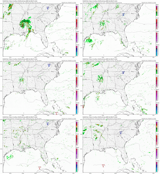
I would expect most of our Tennessee counties to stay dry through the first half of the afternoon with only our Mississippi counties possibly seeing a scattered shower or two. As we move into the late afternoon to evening hours and into tomorrow, our rain chances will continue to increase with thunderstorms becoming more likely on Thursday.
 |
| The NAM 3km model shows scattered showers moving through the Mid-South tonight into tomorrow. (Tropical Tidbits) |
Overall, temps will remain in the upper 80s for our highs and mid 70s for our lows over the next two days.
Friday & Saturday
As we reach the end of the week and beginning of the weekend, scattered showers are anticipated to stick around. Luckily, we are not expecting a wash out, just scattered cloud coverage with the occasional shower/thunderstorm or two. Highs will remain near 90 both days with overnight lows in the mid 70s.
Sunday into the beginning of next week
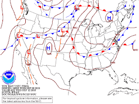
Clouds and showers will begin to return on Sunday as we enter back into another wet period. A surface cold front will begin to swing down to our area to start next week, but it won't ever completely pass through our area. Instead, the front is expected to stall out over our area and hang around for the first half of the week.
 |
| WPC surface forecast for Monday shows a surface low pressure over the Ohio River Valley with a corresponding front draped over the Mid-South. (NOAA/WPC) |
 |
| WPC shows this same front (48 hours later) still draped over the Mid-South, but has now become stationary. (NOAA/WPC) |
The good news is that this will help keep clouds and rain over our area, which in turn will help our temps stay in the mid 80s for the first half of next week. The bad news, depending how you look at it, will be that scattered showers and thunderstorms will be possible each day Sunday through Tuesday.
The best advice we can give at this point is to expect cooler temps next week with showers being possible each day. The forecast will become more fine-tuned as we head towards the beginning of next week, so be sure to reference the links below each day for the most up-to-date forecast.
MWN Meteorologist Intern
----
Follow MWN on Facebook and Twitter for routine updates and the latest info!
Complete MWN Forecast: MemphisWeather.net on the mobile web or via the MWN mobile app
Download our iPhone or Android apps, featuring StormWatch+ severe weather alerts!
 |  |
| MWN is a NOAA Weather Ready Nation Ambassador | Meteorologist Erik Proseus is an NWA Digital Seal Holder |


No comments:
Post a Comment