Pages

Monday, October 29, 2018

6 Things You Need to Know about the Halloween Forecast

Above average temperatures look to continue through the first half of this week before an anticipated cold front brings cool temps in for the second half of the week and into the weekend. Unfortunately, this cold front and rain will likely move through Wednesday evening, during the peak of Halloween festivities. Lots of events will be ongoing, but you should go ahead and prepare for rain that night.

Monday through Wednesday

Our brief period of "warming up" will continue through the first half of this week. A high pressure systems remains situated over the southeastern portion of the U.S., but that is expected to change in the coming days. As our anticipated low pressure system (bringing us the cold front on Wednesday) moves closer to our area, this high pressure will continue to get pushed farther to the east. For the remainder of today and into tomorrow, skies will remain mostly clear. Although, we will begin to see a slight increase in cloud cover tomorrow. 

Weather Prediction Center (WPC) frontal analysis for this afternoon shows high pressure dominating the Mid-South region. (NOAA/WPC)
WPC frontal analysis for Tuesday evening shows our high pressure pushed to the east with an incoming cold front from our west. (NOAA/WPC)
Something interesting to note is as this high pressure gets moved to the east, with the decreasing pressure to our west, we will see a noticeable difference in our winds on Tuesday and Wednesday. Both days, winds could reach 15 mph with gusts upwards of 25 mph. 

NAM1winds and mean sea level pressure analysis from this afternoon through Wednesday morning display this increase of surface wind speeds Tuesday and Wednesday across our area. (TropicalTidbits)
If you have Halloween decorations out, you may want to ensure that they are secure as gusts could make some loose decorations go flying.


As for our temperatures through the first half of the week, we will stay pretty warm if you ask me. Highs will reach near 81 on Tuesday and near 76 on Wednesday, both of these are considered above average for late October. Temps will stay fairly mild tonight and tomorrow night with lows near 56 tonight and near 66 Tuesday night. 

Wednesday will be when we really begin to notice things changing in our weather pattern thanks to a cold front that will pass through the area. We know that Wednesday is Halloween and a lot of you likely have plans of some kind. For that reason, we decided to include a Q&A that will hopefully answer any questions you may have about trick or treating! 


6 Things You Need to Know about the Halloween Forecast:

1. What time will the rain arrive?
We are expecting for the majority of the showers/thunderstorms to move through Wednesday afternoon into Wednesday night. A scattered shower or two will be possible earlier in the day, but the majority will hold off until later in the day, with rain most likely after 4pm and well into the nighttime hours.

NAM model displays showers beginning by Wednesday afternoon with rain continuing into the overnight hours. Showers will begin to move out sometime on Thursday. (TropicalTidbits)
For those with afternoon/evening Halloween plans, I would have the rain plan ready to go. Bring the umbrella if you are planning to go outside and rain boots would be advised. However, there are a couple more complicating factors...

2. How much rain are we talking?
Pretty much everyone will see rainfall on Wednesday, but amounts will likely vary depending where the heaviest bands of precipitation move through. Generally speaking, anywhere from an inch to potentially even three inches will be possible. Locally higher amounts could be possible as well. 

WPC shows the Mid-South potentially receiving some of the highest rainfall amounts Wednesday through early Thursday morning (NOAA/WPC)
While widespread severe weather is not expected (more on this later), heavy rainfall could become an issue on Wednesday evening. The Weather Prediction Center has included us in their "slight" risk for excessive rainfall for Wednesday. Essentially, this highlights our area for having a lot of rainfall over a short amount of time, which could lead to some ponding of water and localized flooding issues. This will be something to keep an eye on as we get closer to Wednesday evening. but that will make for some VERY wet children and chaperones if this pans out!

WPC has included much of the Mid-South in a slight risk for excessive rainfall on Wednesday (NOAA/WPC)

3. Thunderstorms too? Could any be severe?
Thunderstorms will certainly be possible, especially Wednesday evening, as the main line pushes through the area. In general, heavy rain and lightning appear to be the main concerns, but an occasional strong wind gust can't be completely ruled out. At this time, there does not appear to be a widespread severe weather threat. The Storm Prediction Center keeps the severe threat to our southwest, with only a "general thunder" risk over our area. But that still means a chance of thunder and lightning, and we definitely wouldn't want any of you becoming a lightning rod for Halloween!

SPC keeps the main severe weather threat area to our southwest with Memphis and the majority of the Mid-South only included in the general thunderstorm risk. (NOAA/SPC)
4. How about the temperatures?
Assuming the rain and thunder forecast becomes a bit more favorable, will it be cold, or sweaty? Temps will generally be in the lower 70s/upper 60s through the early evening hours before dipping into the mid 60s through the remainder of the evening. The persistent showers will likely make it feel a bit cooler than this throughout the evening. 


5. A lot of wind too?
As discussed in the previous section, winds will become fairly gusty on Wednesday and into Wednesday evening. Winds will remain from the southwest around 10 to 15 mph with gusts upwards of 25 mph. Having a way to secure any Halloween decorations and/or a hat to go with your costume would be advised. 

6. Tell it to me straight. Are you confident all this will occur?
We are confident that it is going to rain on Wednesday night unfortunately. Umbrellas would be advised if you are planning to embrace the rain. What we are "less" confident about would be thunderstorms and their severity. This is something to keep an eye on over the next few days, but at this time heavy rain, lightning, and a couple of strong wind gusts appear to be the main concerns. Honestly, it's not really looking that great. The hope is that it is all delayed a couple hours and maybe some early candy-grabbing can take place!


Thursday and Beyond

We will begin to shift back into a cooler temperature and hopefully somewhat dry pattern starting on Thursday. Leftover showers from Wednesday's frontal passage could remain Thursday morning, but should begin to clear out by the afternoon. Enough moisture Friday into the weekend causing scattered showers to remain possible, but coverage should not be widespread and I expect most weekend activities to be quite pleasant actually. Highs look to stay in the 60s through the weekend with overnight lows in the 40s.


Caroline MacDonald
MWN Meteorologist

----
Follow MWN on Facebook and Twitter for routine updates and the latest info!
Complete MWN Forecast: MemphisWeather.net on the mobile web or via the MWN mobile app
Download our iPhone or Android apps, featuring StormWatch+ severe weather alerts!
MWN is a NOAA Weather Ready Nation Ambassador Meteorologist Erik Proseus is an NWA Digital Seal Holder

Saturday, October 27, 2018

An awesome fall weekend, but Halloween could be ghoulish..

We have a great weekend ahead! This is what fall feels like!


In the wake of rain and dreariness the past couple of days, skies have cleared out nicely this morning and high pressure will be moving by to our north, resulting in a fantastic weekend if you have outdoor plans. Highs today rise into the mid 60s following a crisp autumn morning. Sunday will be even better as wind shifts to the south briefly, helping to push temperatures into the mid 70s by afternoon. A dry, cloud-less cold front is expected mid-day which will turn those winds around to the northwest, but won't have an effect on temperatures. Expect a decent breeze all day.


The pleasant trend continues as we start the week with sunny skies Monday and slightly cooler temperatures behind Sunday's front, but still eclipsing the 70° mark. On Tuesday, south wind picks up again with high clouds increasing as temperatures push well into the 70s, with an outside shot at a few locations seeing 80°! The increase in clouds may be the only thing that keeps most of us from seeing a temperature that starts with an '8' for the first time in nearly three weeks.

Unfortunately, the wettest system in some time looks like it will choose Wednesday, Halloween Day, to move across the region. There will also be some decent upper level support with the approaching cold front, so some thunderstorms are also expected. It's too early to know if there could be some strong storms, but the NWS has signaled the possibility, with low confidence. Rainfall amounts on Wednesday could easily eclipse an inch and a couple of inches is not out of the question. If you have the opportunity to try out those costumes this weekend at a local fall festival, we strongly recommend it!

NWS-Memphis is indicating a few strong storms are possible for Halloween. Confidence for now is low (1/5). (NWS-Memphis)

The overnight run of the European model is bullish on precipitation totals for the mid-week system with perhaps 2"+ in the metro region. The development of a low pressure area along the front and potential storms will drive rainfall totals. (WxBell) 

Model trends the last few days have been varying for trick-or-treat hours Wednesday night with some solutions indicating that the rain might move through more quickly, while others paint a very ghoulish forecast that would likely preempt all but the most dedicated of sugary-treat gatherers. The latest runs of the American GFS, European, and Canadian models all indicate that the front itself could move through by the evening hours, but lots of things could change that forecast. Halloween fans should hope for a quick frontal passage, which could mean just light rain and cool temperatures Wednesday evening. We'll hopefully have a more solid forecast by early in the week, which we'll post to the blog. Our best guess at temperatures Wednesday evening is about 60°, plus or minus 5°.

Behind the mid-week front, trends show fairly decent improvement by Thursday into the end of the week. It will definitely be back to cooler weather, and we'll be watching for the potential of upper level systems to produce a chance of rain here or there. For now, we're sticking with cool for the period about a week from now.


Erik Proseus
MWN Meteorologist

----
Follow MWN on Facebook and Twitter for routine updates and the latest info!
Complete MWN Forecast: MemphisWeather.net on the mobile web or via the MWN mobile app
Download our iPhone or Android apps, featuring StormWatch+ severe weather alerts!
MWN is a NOAA Weather Ready Nation Ambassador Meteorologist Erik Proseus is an NWA Digital Seal Holder

Tuesday, October 23, 2018

Sunshine holds on for a little longer, rain chances return by Thursday

Below average temps continue to be the main talking point of our overall weather pattern. This week has been fairly dry so far, but that looks to change for the second half of the week into the beginning of the weekend. Luckily, while we will see an increase in precipitation, our below average temps will continue for the foreseeable future.

Today

Yet another pleasant, fall day on tap as a high pressure system positioned over the southeast continues to keep rain chances away (for now). We could see a few additional clouds today compared to yesterday, but nonetheless partly sunny skies will remain. 


Highs will reach near 70 this afternoon with lows dropping down to 47 tonight. Winds will stay out of the northeast around 5 to 10 mph.

Tomorrow

While we won't see any major changes tomorrow, we will see a few differences. A weak cold front is expected to move through later today, which will help temps to drop a few degrees tomorrow. Highs will only reach the mid 60s. Additional high pressure will move in behind this cold front, allowing skies to clear out a bit more tomorrow.

Weather Prediction Center frontal map shows a cold front that has pushed through the southeast with a high pressure funneling in behind. (NOAA/WPC)

While mostly sunny conditions will remain through the first half of the day, clouds will begin to increase in the evening ahead of increasing showers late tomorrow night into Thursday. Lows will fall into the upper 40s.

Thursday & Friday

We will notice a distinct pattern shift for the second half of the week as we move away from sunny skies and more into a cloudy, rainy pattern. Thursday will be characterized by light showers throughout the majority of the day with light showers continuing into the first half of Friday.

GFS shows showers moving through the Mid-South throughout Thursday into the first half of Friday. (Tropical Tidbits)
Some interesting features are actually leading to this dreary period. To our west, an upper-level trough pattern will begin to develop on Wednesday. Energy from the northwestern U.S. combined with energy from the desert southwest and the remnants of Willa (currently a major hurricane expected to make landfall in Western Mexico) will help to create the shortwave pattern that will bring showers to our area.

An upper-level map from the GFS shows all three energy waves combining by the time they move over the Mid-South. (Pivotal Weather)

You will want to keep the umbrella handy Thursday and Friday. While showers should remain light, there could be some pockets of heavier rainfall worthy of an umbrella.


Additionally, this shortwave will help to keep temps below average through the foreseeable future. High temps will remain in the upper 50s to near 60 both days with overnight lows nearing the upper 40s to 50.

This Weekend

Clouds and some lingering, scattered showers will hang around into Saturday behind the aforementioned shortwave. Highs will near the mid 60s on Saturday with overnight lows dipping into the upper 40s.

We will begin to see some cloud coverage clearing into Sunday as things dry out across the Mid-South. Partly cloudy conditions will be in place by Sunday afternoon with highs in the lower 60s and lows in the upper 40s once again.

Next Week

For those who have been enjoying all of this cooler weather, you are in luck! Cooler temps are expected to continue into next week.

The Climate Prediction Center (CPC) keeps our area in the well below average category through next week. (Pivotal Weather)
CPC continues to show a slightly above average precipitation pattern into next week. (Pivotal Weather)
You'll want to keep the extra blankets out for the overnight hours too; temps will continue to dip into the 40s overnight.


Caroline MacDonald
MWN Meteorologist

----
Follow MWN on Facebook and Twitter for routine updates and the latest info!
Complete MWN Forecast: MemphisWeather.net on the mobile web or via the MWN mobile app
Download our iPhone or Android apps, featuring StormWatch+ severe weather alerts!
MWN is a NOAA Weather Ready Nation Ambassador Meteorologist Erik Proseus is an NWA Digital Seal Holder

Tuesday, October 16, 2018

Cooler temps for all, rain chances today and to end the week

Oh fall, you have been so good to us this week. I don't know about you, but I have certainly enjoyed the cooler weather we have had over the last few days. Thankfully, this cooler weather looks to stay for a while as we head into the second half of October. Today will continue to be a bit soggy, but we do have a break from the rain chances coming.

Today

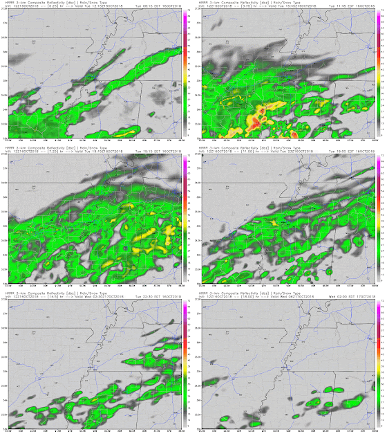
While we've stayed relatively dry so far, expect for that to change as we push through the day. Light showers continue to drift towards our area as we speak and will reach us by this afternoon.

HRRR shows this funnel of showers moving through the Mid-South through the majority of this afternoon with showers leaving during the evening hours. (WeatherBell)

While showers should remain light, they will stick around long enough that you will likely want to keep your umbrella handy for the rest of the day. This will be a chilly rain folks. 


Additionally, temps will not warm up that much today. Temps currently sit in the mid 40s and will only rise into the mid 50s by the end of the day. This will leave our highs nearly 20 degrees below normal ("normal" is around 74). Luckily temps won't fall too much overnight, leaving lows around 46 under a mostly cloudy sky.

Tomorrow & Thursday 

After our wet day today we will see a brief, couple day break from all of the soggy rain. Tomorrow and Wednesday look like pretty nice days to embrace the fall weather. While some clouds will be present each day, enough sunshine will be around to help highs warm into the low to mid 60s (which is still a few degrees below average). Overnight temps will cool off into the mid 40s. 


Friday & Saturday

Our period of dryness could only last so long as rain chances return to end the work week and begin the weekend. The main time frame we are looking at showers is anytime from Friday afternoon until Saturday morning. Friday morning and Saturday afternoon/evening look to remain dry at this point. Highs will remain in the low to mid 60s both days with overnight lows falling into the low 50s to near 50. 

GFS loop from Friday morning through Saturday afternoon shows showers arriving in the Mid-South during the afternoon on Friday and moving out early Saturday morning. (Tropical Tidbits)

Next Week

After Friday and Saturday morning's showers, we will begin to transition into a pretty dry period. Most models and outlooks for next week show minimal rain chances through the majority of next week. For those who have wanted a break from the soggy weather, it's coming.

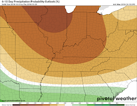
Climate Prediction Center (CPC) keeps the Mid-South in the slightly below average precipitation category for much of next week. (Pivotal Weather)
The good news along with this period of dryness is that temps will remain cooler. Even though high pressure looks to build in for much of next week, temps look to remain below average.

CPC keeps the Mid-South in the below average temperature category for next week. (Pivotal Weather)

Caroline MacDonald
MWN Meteorologist

----
Follow MWN on Facebook and Twitter for routine updates and the latest info!
Complete MWN Forecast: MemphisWeather.net on the mobile web or via the MWN mobile app
Download our iPhone or Android apps, featuring StormWatch+ severe weather alerts!
MWN is a NOAA Weather Ready Nation Ambassador Meteorologist Erik Proseus is an NWA Digital Seal Holder

Friday, October 12, 2018

Fall Is Here, Sergio brings Sunday rain, then Cold Blast #2

It is no argument that Fall has finally arrived with the surge of cooler air. All of that is thanks to Wednesday's cold front that came through. We do have some changes coming in the forecast over the next seven days; however, no worries! Our cooler weather is here to remain. Instead, we do have a decent amount of rain on the way, thanks partially to Sergio.

Tonight


A weak boundary moving through this afternoon and into tonight is bringing a short lived chance at some stray rain this evening and into tonight. As mentioned, rain will be light. Likewise, the wave will be weakening as it moves through so not everyone will see rain.

Light showers move through this evening as a weak boundary moves through the Mid-South. Source: HRRR model, WeatherBell
Clouds that arrive with this rain will be sticking around overnight and into tomorrow. These clouds will hold in some heat tonight, preventing us from dipping into the 40s. Instead, we will see lows in the lower 50s. Rain chances drop off tonight and we remain dry until at least mid-day Saturday.

Tomorrow (Saturday)


We start the weekend dry Saturday, but Sergio, formerly a major hurricane in the eastern Pacific that made landfall in Baja California early this morning, plans to change that, along with the help of a new low pressure system. That new developing low is what picks up Sergio and brings it over to the Mid-South. The moisture from this tropical remnant will start to bring light, scattered rain as early as late Saturday afternoon. As we move into the night, rain chances quickly ramp up. Thanks to the clouds Saturday afternoon, high temps remain in the upper 60s. As it stands now, most of the University of Memphis football game vs. Central Florida should remain dry, though if rain does arrive during the contest, it will be light.

3km NAM brings 1-1.5 inches of rain for the Memphis area by Sunday afternoon thanks to Sergio's remnants. (WeatherBell)

Saturday night, rain chances ramp up as steady rain moves in thanks to Sergio's remnants and a northward bound warm front from the parent frontal system that will be steering Sergio. That lifting warm front will bring in some warmer air, so Saturday night we only drop into the upper 50s to right at the 60 degree mark.

Sunday and Monday


If you thought that rain was going anywhere any time fast, you were wrong. The front takes its sweet time getting out of the Mid-South. That said, look for showers through the day Sunday, Sunday night, and into the earlier half of Monday as well. Lighter precipitation is possible during a relative lull Sunday afternoon, but look for rain rates to pick back up Sunday night.

Rain chances remain high, seen here with simulated reflectivity from the GFS model for Sunday evening. (Tropical Tidbits)


Temps through this time will remain slightly warmer than what we've recently seen, until Monday. Sunday climbs into the lower 70s. Sunday night, as the front pushes through, temps will be dropping into the mid 50s. By Monday, the front will finally be bringing with it cooler weather, so our high around 63 will be earlier in the day.

Tuesday


Here comes some serious cooler weather, so prep for a true surge of Fall obsession! With the front moving through Monday, Tuesday looks to be the coolest part of our upcoming forecast. Lows Tuesday morning will be in the upper 40s as clouds linger. As we move through the day, there will remain the slight chance of a shower as the front finishes its exit. Meanwhile, cooler air keeps funneling in. By that afternoon, we will only top off in the mid 50s. Talk about Fall-feels!

Look for a new surge of cool air Monday afternoon into Tuesday with lows Tuesday AM in the upper 40s. (WeatherBell)


Wednesday-Friday


Wednesday starts with another chilly morning in the upper 40s for lows. In fact, Wednesday, Thursday, and Friday mornings will see lows in the upper 40s. Highs remain pleasant not only for Wednesday, but Thursday and Friday as well where we will have highs in the mid 60s. Skies conditions will vary through this period as Wednesday will see a mix of sun and clouds. Thursday will see cloud cover increasing. By Friday, skies will be mostly cloudy as rain chances start to slightly increase with the introduction of a new system.

Reggie Roakes
MWN Meteorologist

----
Follow MWN on Facebook and Twitter for routine updates and the latest info!
Complete MWN Forecast: MemphisWeather.net on the mobile web or via the MWN mobile app
Download our iPhone or Android apps, featuring StormWatch+ severe weather alerts!
MWN is a NOAA Weather Ready Nation Ambassador Meteorologist Erik Proseus is an NWA Digital Seal Holder

Wednesday, October 10, 2018

September 2018 Climate Data for Memphis, TN

September Climate Recap

The month of September ended warmer than average overall, and the warmth was generally persistent throughout the month. With the exception of four below average days around the 10th, which featured a few days with highs in the 70s, every day was above average except three. In fact, nearly half the month (14 days) featured highs at or above 90°. This is nearly a week of 90° days above average. No records were set, but Memphis did reach 95 twice in the third week of September.

Precipitation was also fairly abundant in September with nearly 3 inches falling at the airport from the 7th to 9th and additional rainfall totaling nearly 2" from the 23rd to 25th. Flood Advisories were issued for the metro on the 8th due to heavy rainfall from thunderstorms, though no reports were received of flooding. There was no severe weather during the month.

Memphis International Airport, Memphis, TN


Temperature
Average temperature: 77.8 degrees (2.6 degrees above average)
Average high temperature: 85.5 degrees (0.4 degrees above  average)
Average low temperature: 70.1 degrees (4.9 degrees above average)
Warmest temperature: 95 degrees (19th, 20th)
Coolest temperature: 58 degrees (29th)
Heating Degrees Days: 1 (10 below average)
Cooling Degree Days: 395 (79 above average)
Records set or tied: None.
Comments: Fourteen days recorded high temperatures at or above 90 degrees, which is 6.3 days above average.

Precipitation
Monthly total: 5.27" (2.18" above average)
Days with measurable precipitation: 11 (3.7 days above average)
Wettest 24-hour period: 1.26" (24th)
Snowfall: 0.0"
Records set or tied: None
Comments: Four days recorded more than 0.5" of rain.

Miscellaneous
Peak wind: Southwest/30 mph (7th)
Average wind: 6.6 mph
Average relative humidity: 76%
Average sky cover: 50%

Click here for a daily statistical recap for Memphis International Airport.

Cirrus Weather Solutions / MemphisWeather.net, Bartlett, TN


Temperature
Average temperature: 75.8 degrees
Average high temperature: 86.4 degrees
Average low temperature: 67.3 degrees
Warmest temperature: 96.8 degrees (19th)
Coolest temperature: 54.6 degrees (29th)
Comments: None.

Precipitation
Monthly total: 5.23" (automated rain gauge), 6.42" (manual CoCoRaHS rain gauge)
Days with measurable precipitation: 12
Wettest date: 2.15" (8th) (via automated gauge)
Snowfall: None
Comments: None

Miscellaneous
Peak wind: Northwest/20 mph (26th)
Average relative humidity: 83%
Average barometric pressure: 30.02 in. Hg

Click here for a daily statistical recap for Bartlett, TN.

MWN Forecast Accuracy

MWN average temperature error: 1.74 degrees
MWN forecast temperatures within 2 degrees of actual: 76%
MWN average dewpoint error: 1.66 degrees
MWN forecast dewpoints within 2 degrees of actual: 76%

MWN's forecasts extend out five periods (2.5 days, or roughly 60 hours). Historical accuracy statistics can be found here.

Climate Outlook - October

The October climate outlook for the United State from the Climate Prediction Center is shown below. Temperatures are forecast to be above normal for much of the southern and eastern United States. For Memphis, odds of above normal temperatures in October are 70%, near normal 27% and below normal just 3%. Memphis typically averages just 64 degrees for the month of October, or about 14 degrees cooler than the September we just experienced.


A wet October is forecast for much of the United States with the exception of the Pacific Northwest and eastern seaboard and southeast. For Memphis, odds of above normal precipitation in October are 40%, near normal 33% and below normal 27%, or not far from equal chances of above/below. October averages about 4" of rain in Memphis.


----
Follow MWN on Facebook and Twitter for routine updates and the latest info!
Complete MWN Forecast: MemphisWeather.net on the mobile web or via the MWN mobile app
Download our iPhone or Android apps, featuring StormWatch+ severe weather alerts!
MWN is a NOAA Weather Ready Nation Ambassador Meteorologist Erik Proseus is an NWA Digital Seal Holder