Today
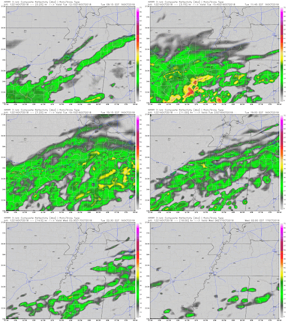
While we've stayed relatively dry so far, expect for that to change as we push through the day. Light showers continue to drift towards our area as we speak and will reach us by this afternoon.
 |
| HRRR shows this funnel of showers moving through the Mid-South through the majority of this afternoon with showers leaving during the evening hours. (WeatherBell) |
While showers should remain light, they will stick around long enough that you will likely want to keep your umbrella handy for the rest of the day. This will be a chilly rain folks.
Additionally, temps will not warm up that much today. Temps currently sit in the mid 40s and will only rise into the mid 50s by the end of the day. This will leave our highs nearly 20 degrees below normal ("normal" is around 74). Luckily temps won't fall too much overnight, leaving lows around 46 under a mostly cloudy sky.
Tomorrow & Thursday
After our wet day today we will see a brief, couple day break from all of the soggy rain. Tomorrow and Wednesday look like pretty nice days to embrace the fall weather. While some clouds will be present each day, enough sunshine will be around to help highs warm into the low to mid 60s (which is still a few degrees below average). Overnight temps will cool off into the mid 40s.
Friday & Saturday
Our period of dryness could only last so long as rain chances return to end the work week and begin the weekend. The main time frame we are looking at showers is anytime from Friday afternoon until Saturday morning. Friday morning and Saturday afternoon/evening look to remain dry at this point. Highs will remain in the low to mid 60s both days with overnight lows falling into the low 50s to near 50.
 |
| GFS loop from Friday morning through Saturday afternoon shows showers arriving in the Mid-South during the afternoon on Friday and moving out early Saturday morning. (Tropical Tidbits) |
Next Week
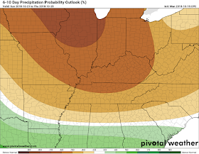
After Friday and Saturday morning's showers, we will begin to transition into a pretty dry period. Most models and outlooks for next week show minimal rain chances through the majority of next week. For those who have wanted a break from the soggy weather, it's coming. |
| Climate Prediction Center (CPC) keeps the Mid-South in the slightly below average precipitation category for much of next week. (Pivotal Weather) |
 |
| CPC keeps the Mid-South in the below average temperature category for next week. (Pivotal Weather) |
MWN Meteorologist
----
Follow MWN on Facebook and Twitter for routine updates and the latest info!
Complete MWN Forecast: MemphisWeather.net on the mobile web or via the MWN mobile app
Download our iPhone or Android apps, featuring StormWatch+ severe weather alerts!
 |  |
| MWN is a NOAA Weather Ready Nation Ambassador | Meteorologist Erik Proseus is an NWA Digital Seal Holder |


No comments:
Post a Comment