Looking over the next week or so, temperatures will remain fairly comfortable for the end of March and beginning of April. We will see some above-average temperatures over the next few days, with some cooler temps this weekend before things warm back up into the middle to end of next week.
Rest of today and tomorrow
Our sky will continue to remain mostly clear for the remainder of today into the overnight hours. For those with evening plans tonight, temps should remain in the upper 50s to low/mid 60s through most of the evening.
 |
| Visible satellite imagery from around 4 PM this afternoon shows a few, high cirrus clouds moving across the Ozarks region. (College of DuPage) |
Another beautiful day is on tap for tomorrow. Despite the occasional cloud or two, temps will reach to near 73 by the afternoon. While it won't quite be the weekend, tomorrow will be one of those days that makes you wish it was. If you get the chance to be outside tomorrow, be sure to enjoy it!
Friday
Things will still be pretty warm on Friday, with highs reaching near 72. Despite these above-average temperatures, we will see a few more clouds filling our skies with mostly cloudy conditions expected throughout the day. Although, we will have enough moisture present that a scattered shower or two cannot be completely ruled out. We aren't expecting a full-on washout, but some could see some showers by the afternoon and evening hours.Saturday
Unfortunately, our one day of likely rain has to fall over the weekend. While highs will still reach into the upper 60s, you will need your umbrella more than your sunglasses on Saturday. A cold front moving through the region will help to initiate some showers and thunderstorms. Scattered showers will be possible during the morning hours, before becoming more likely in the afternoon to evening hours. All of these showers will pass through by the early morning hours on Sunday. |
| The GFS model shows scattered showers moving through the Mid-South as a cold front pushes through the area. (Tropical Tidbits) |
 |
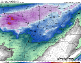
| The Weather Prediction Center shows around half an inch of precipitation falling on Friday and Saturday with the majority of this coming on Saturday. (Pivotal Weather) |
Sunday into the rest of next week
Following a somewhat dreary Saturday, Sunday fills all of our hopes and dreams of a dry weekend (even if it's just for a day). While things may be a bit on the chillier side, with highs only expected to reach the mid 50s, partly sunny skies will return. Looking into next week, high pressure will begin to move into the region, helping to keep away most showers through the beginning of next week.
 |
| The Weather Prediction Center's Day 6 surface forecast shows a high pressure system extending throughout much of the southeast, keeping any frontal system away from our area. (NOAA/WPC) |
There is a small chance of a scattered shower on Monday, but the rest of the week appears to be rain-free for now. Highs will slowly creep up throughout the week, only reaching the upper 50s by Monday before leaping up into the lower 70s by Wednesday.
Caroline MacDonald
MWN Meteorologist
----
Follow MWN on Facebook and Twitter for routine updates and the latest info!
Complete MWN Forecast: MemphisWeather.net on the mobile web or via the MWN mobile app
Download our iPhone or Android apps, featuring StormWatch+ severe weather alerts!
 |  |
| MWN is a NOAA Weather Ready Nation Ambassador | Meteorologist Erik Proseus is an NWA Digital Seal Holder |


No comments:
Post a Comment