Rest of today
Pleasant conditions are expected to hang around for the remainder of the day. Satellite imagery from this afternoon shows a few more clouds beginning to move into the area. Expect for this trend to continue as we move into the evening hours.
 |
| Visible satellite imagery from GOES-16 this afternoon shows clouds moving over much of the Mid-South with more clouds slowly drifting eastward. (College of DuPage) |
Tonight, expect for skies to remain mostly cloudy as overnight lows fall to near 62.
Wednesday
Tomorrow appears to be one of those it may rain/it may not type of days. What do we mean by this? Well for the first half of the day through the early afternoon hours, we should stay dry for the most part with mostly cloudy conditions overhead and highs nearing 79. However, by mid-afternoon to evening hours we will become fair game for some scattered shower activity. Most computer models want to keep scattered showers primary to our north, but it will be pretty close. A stray shower cannot be completely ruled out.
 |
| NAM3 from tomorrow afternoon through late tomorrow night shows scattered showers beginning to develop in the afternoon and moving just to the north of much of the Mid-South area. (Tropical Tidbits) |
Widespread showers are not expected to arrive until early Thursday morning.
Thursday
We've got some bad news for you Miss Rhode Island, Thursday does not appear to be that great of a day weather-wise. Highs will reach near 72 by the afternoon, so a light jacket probably won't be needed. However, you will want a rain jacket and/or umbrella. Showers are expected throughout the day with a few thunderstorms possible.
 |
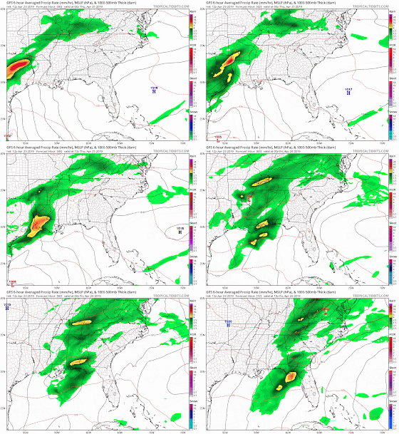
| GFS precipitation loop from Wednesday evening through late Thursday evening. (Tropical Tidbits) |
Now you may be thinking, are we expecting yet another round of severe weather? Luckily, no severe weather is expected with any thunderstorms that may develop, just heavy rain and lightning at times is possible. Why, you may ask? Well, it all has to do with the low pressure system driving the cold front helping to bring the precipitation. The low pressure system (you may have noticed this on the precipitation loop above) tracks through Arkansas and into Mississippi without going to our north. For us, this a good thing because it keeps some of the severe weather ingredients needed away from our area and to the south, leaving us with just some general thunderstorms.
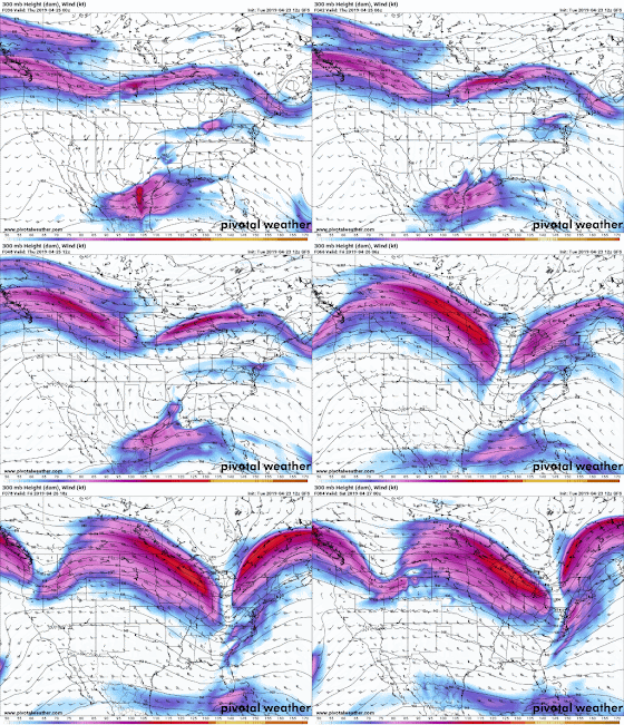
If you want another nerdy explanation/visualization, look no further. The graphic below represents 300mb (jetstream level) pressure and wind, which is just a big fancy way for meteorologists to get an idea of the overall flow pattern in the atmosphere (i.e. where the trough/ridges are). At the beginning of the graphic, we can see faster winds over the western U.S, forming a ridge-like pattern. By the middle of the sequence, you can see some of these upper-level winds beginning to create a trough-like feature over the eastern half of the U.S. You may notice the bottom of this trough (the U type appearance) moves through areas primarily south of the Memphis area. This just goes to show that what is occurring high in the atmosphere is driving what is occurring at the surface (i.e. where the bottom of the trough is located is closely located to where the "L" appears on the graphic early).
Going back to what we can expect on Thursday, heavy rainfall will be possible at times and could lead to some ponding in low-lying areas. Although, widespread flooding is not expected. When all is said and done, most of the Mid-South is expected to receive around an inch in rainfall, more or less.
Friday
Wave goodbye to the gloomy weather and rain because beginning on Friday we are expecting lots of sunshine in our forecast. Mostly sunny conditions are expected throughout the day with highs reaching near the mid 70s. Keep those sunglasses handy folks!
This Weekend and Next Week
Sunshine for all! Besides some mainly high clouds and a very small chance of a shower, this weekend looks pretty fantastic if you ask me. Temps will remain near average in the mid 70s with overnight lows in the 50s. Saturday and Sunday look to be a good combination of warmer temperatures, but not too warm that they are unbearable. If you have outdoor plans this weekend, enjoy them!
Into early next week, rain chances should remain minimal to non-existent as much of our area remains under the influence of a high pressure system. Additionally, temps could get pretty toasty next week, with highs expected to rise into the 80s.
MWN Meteorologist Intern
----
Follow MWN on Facebook and Twitter for routine updates and the latest info!
Complete MWN Forecast: MemphisWeather.net on the mobile web or via the MWN mobile app
Download our iPhone or Android apps, featuring StormWatch+ severe weather alerts!
 |  |
| MWN is a NOAA Weather Ready Nation Ambassador | Meteorologist Erik Proseus is an NWA Digital Seal Holder |


No comments:
Post a Comment