First, overnight tonight (Tuesday) and much of Wednesday appears to be dry for most, as there are no real "triggers" for showers and storms despite the humid airmass in place. In fact, tomorrow will likely be pretty hot (actually, right at normal) with highs near 90 and heat indices well into the 90s. Southwest breezes will also pick up in the afternoon with gusts in the 20s. A stray shower or thunderstorm is possible in the heat of the afternoon, but your guess is as good as mine as to where. We'll go with a 30% chance of rain.
Wednesday night is when a frontal system approaches, but more importantly, some upper level support that will serve to fire off thunderstorms in our humid and unstable air. The timing on these is still hard to pin down, but most of us will likely hear thunder overnight, and perhaps multiple rounds. By dawn, most of the rain and convective weather will be to our east, leaving diminishing clouds in their wake Thursday.
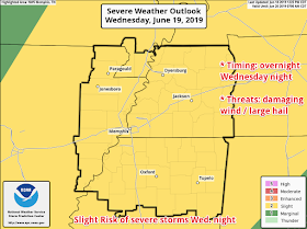
As for the severe weather chances, the Storm Prediction Center currently has our area in the middle of a Slight Risk (level 2 of 5) for the overnight hours. Damaging wind will be the main concern, while some hail can't be ruled out. Of course, heavy downpours and lightning are a given. Tornadoes are not a concern.
Many areas could pick up over an inch of rain (and for many of us, that would be kind of welcome!). Chances of this risk increasing seem pretty low, especially given the overnight timing of the storms. Keep an eye on our social media feeds for any changes on Wednesday.
Heading into the weekend, rain chances appear pretty low (0-20%) from Thursday afternoon through Sunday morning. It will be very toasty with highs creeping back up above normal (lower 90s) and lows in the muggy mid 70s. The next frontal system that should have an impact arrives Monday.
Erik Proseus
MWN Meteorologist
----
Follow MWN on Facebook and Twitter for routine updates and the latest info!
Complete MWN Forecast: MemphisWeather.net on the mobile web or via the MWN mobile app
Download our iPhone or Android apps, featuring StormWatch+ severe weather alerts!
 |  |
| MWN is a NOAA Weather Ready Nation Ambassador | Meteorologist Erik Proseus is an NWA Digital Seal Holder |


No comments:
Post a Comment