Pages

Wednesday, August 21, 2019

A pattern shift is coming - goodbye heat! (Hello rain!?)

I haven't had near as much response to a social media post of late as I did a couple days ago announcing that the hot spell to start this week could well be the last with Heat Advisories included for the rest of 2019! Some of y'all are ready for fall!


No more heat (advisories)!

As I type this, that Heat Advisory is about to expire and I still feel the same way I did a couple days ago. Heat abates a bit to end the week as highs slip back towards 90, then into the 80s throughout the weekend and into next week. One thing that will not go away quite yet though is the humidity. As a wetter pattern sets up, dewpoints will remain in the 70s, so it'll be muggy, but just not as hot.


About those rain chances... 

As high pressure releases its grip on the region, the tail end of a trough of low pressure aloft brushes the area to end the week, dragging a cold front into the region.  That will set off scattered showers and thunderstorms starting Thursday and continuing into the weekend, as what will likely be multiple rounds of rainfall develop. The good news is that, while localized deluges could occur, we're not looking at widespread washout-style rains. In fact, total rainfall generalized across the region should be in the 1" range, more in spots that get multiple storms. Severe weather is not a big threat, although a few storms ahead of the front on Thursday could bring locally gusty wind and lightning.

A Marginal Risk (level 1/5) of severe weather exists along and north of the I-40 corridor on Thursday as a few storms could get frisky and drop some strong wind gusts. (SPC)

As we head into the weekend, low pressure aloft develops to our west and shifts into the Mid-South. This will keep rain chances pretty high this weekend and early next week. It's likely that much of this rainfall could be diurnally-driven, meaning it is most prevalent during the warmer parts of the day. Fortunately, "warmer parts" can be defined as mid to upper 80s during that period of time! Mild overnight lows continue as dewpoints remain sticky.

For the upcoming week (through next Wednesday night), rainfall totals look to average about 2" across the region. Some places will see more depending on where storms set up that drop locally heavier rain. (NOAA/WPC via PivotalWx)


First fall front on the horizon?

While we should see a general decrease in precipitation chances (but not to zero) around Tuesday and Wednesday of next week, a fairly substantial push of fall air drops south into the Midwest and Ohio Valley by mid-week. This will help push a cold front through by about Thursday of next week. Extended range temperatures reflect a high likelihood of below average temperatures to end next week and continue into early September. Taken altogether, you see where I get my confidence in the likely end of mid-summer-like temperatures!


Let's now cross our fingers that that front is well to our south by the end of next week, setting the stage for a fabulous night for football as your local Friday Night Lights shine bright, and Saturday at the Liberty Bowl as the Tigers kick off the season at the Liberty Bowl! I sense the start of football season weather!


Erik Proseus
MWN Meteorologist

----
Follow MWN on Facebook and Twitter for routine updates and the latest info!
Complete MWN Forecast: MemphisWeather.net on the mobile web or via the MWN mobile app
Download our iPhone or Android apps, featuring StormWatch+ severe weather alerts!
MWN is a NOAA Weather Ready Nation Ambassador Meteorologist Erik Proseus is an NWA Digital Seal Holder

Saturday, August 10, 2019

Steamy heat settling into the Mid-South

By most standards, this summer has actually been relatively mild in the Memphis metro. While May was warmer than average, the hottest it got was 92°. June's average temperature was 2° below normal and once again the highest temperature was 92°. July also finished a little over a degree below normal despite some hotter days. However, the high temperature only eclipsed the average high (92°) on five occasions and the hottest we got was 95°. Granted the humidity in mid-July pushed the heat index close to 110° a few days, but the end of the month was actually quite pleasant as dewpoints backed off for a good stretch of time. And to start August? Well, Tuesday and Wednesday were in the mid 90s, but otherwise each day has averaged below normal. All that to say - summer isn't over!


Heat builds, humidity lingers

A strong ridge of high pressure in the mid levels of the atmosphere is centered over Texas this morning but will expand east into the Mid-South as we head into the beginning of the week. That ridge will help to push temperatures up into the mid to maybe upper 90s in a few spots by the start of the week.

The European model through Wednesday morning shows a mid-level (500mb, or 18,000 feet) ridge of high pressure expanding from Texas north and east into the area to start the week. Yellow colors show where high pressure is stronger than normal. Blues are anomalously lower pressure areas. You can see at the end of the loop how the yellows retreat though as high pressure weakens. (WeatherBell)

And as you know in the Mid-South, it isn't just the heat, it's the humidity! Plenty of moisture from recent rain, as well as southerly wind originating over the Gulf of Mexico, will keep our dewpoints well above even sultry Memphis standards - in the mid to upper 70s. That means high humidity levels will couple with the building heat to create conditions that could become dangerous.

The NAM model shows forecast dewpoints through mid-day Tuesday. There is no reprieve from mid to upper 70s dewpoints, which means high humidity values to go with the strengthening high pressure. That combination produces excessive heat conditions. (WeatherBell)


A hot forecast

"Typical" summertime heat can be expected today (Saturday) with highs near 90° but with dewpoints in the mid 70s, look for heat indices to top the century mark this afternoon. An isolated shower or thunderstorm can't be ruled out, but most of those will be southwest of Memphis and could affect north MS.

Sunday will see the upper level ridge expand closer. Coupled with low rain chances outside of a few possible morning showers, highs should reach the mid 90s. Dewpoints remain in the mid 70s or a touch higher, so expect heat indices to climb towards 110°. This will match the hottest days we've had so far this summer.


Monday will start even warmer as the ridge builds and dewpoints remain high with lows just below 80°. That will allow highs to climb to the hottest so far this year, around 97°. Dewpoints in the upper 70s will put heat indices at a dangerous level, near 115° in the afternoon, just in time for kids to return to school.


One more day of excessive heat occurs on Tuesday with similar conditions to Monday - heat indices topping out above 110° and high temperatures near 97°. We could start to see a few thunderstorms around the area by Tuesday afternoon and evening. Fortunately, Tuesday marks the end of the excessive heat, so while intense, it won't be prolonged.


A marked shift in the upper level pattern allows a cold front to move through Tuesday night or Wednesday morning. Additional showers and thunderstorms are possible during that period, leaving most of Wednesday dry with falling dewpoints and highs back down to average levels near 90°. The rest of the week should see highs just below average and (better yet) humidity readings also below average!


Heat Preparation and Safety

Excessive heat is nothing to mess around with. First remember that temperature and heat index is computed in the shade! Add multiple degrees if in direct sunlight. A heat index reading above 105° is considered dangerous. Physical effects to the body often build slowly, so it is important to make sure that you are prepared. Of course, avoidance is best. Stay in climate-controlled areas as much as possible and check regularly on those without air conditioning. Warm overnight temperatures will compound the issue.


If you must be out for any length of time, plan frequent breaks and drink plenty of water before before, during, and after exposure. Light-colored clothing that reflects heat and loose-fitting garments that allow the body to breathe are best. Listen to your body and know the effects of heat exhaustion and heat stroke.


You certainly also want to make sure you take care of your pets with plenty of water and a shaded place to stay if they are outside, otherwise allow them in during the hottest parts of the day.

And finally, it should go without saying, NEVER leave a young person unattended in your vehicle for any length of time. It only takes minutes for the inside of a car to get dangerously hot. LOOK BEFORE YOU LOCK.


Erik Proseus
MWN Meteorologist

----
Follow MWN on Facebook and Twitter for routine updates and the latest info!
Complete MWN Forecast: MemphisWeather.net on the mobile web or via the MWN mobile app
Download our iPhone or Android apps, featuring StormWatch+ severe weather alerts!
MWN is a NOAA Weather Ready Nation Ambassador Meteorologist Erik Proseus is an NWA Digital Seal Holder

Sunday, August 4, 2019

July 2019 Climate Data for Memphis, TN

July Climate Recap

While June featured below average temperatures nearly all month, July ended a bit below normal for the month, driven mainly by cooler than average temperatures in the latter half of the month. The first half of July was slightly above normal temperature-wise, but with a maximum for the month of 95 degrees, it didn't get exceptionally hot. The humidity from routine rainfall though made for very hot heat indices. The second half of the month had some above average days, but was well below normal (and much less humid) for about the last 10 days, resulting in slightly cooler than normal temperatures for the month. A low temperature record was tied on the 25th as much of the Mid-South outside the urban heat island fell into the 50s.

Following the fifth wettest June on record, July broke into the top ten wettest as well, almost 3 inches more than average at the airport. As in June though, the southeastern portion of the area was wetter than the northern part of Shelby County with 2 inches more rain at the airport than at MWN in Bartlett, resulting in a difference for the two months combined of about 8 inches between the two sites! The two-month total at the airport was just over 17 inches of rain, good for third wettest June-July on record. A daily rainfall record of 2.28 inches was set on the 16th as remnants of Hurricane Barry moved through the northern Mid-South.

Observed precipitation for July in the Memphis area. (NOAA/WPC)

Departure from average precipitation for July, expressed as percent of normal. (NOAA/WPC)

The main weather hazards in the metro during July were related to heavy rain with multiple Flash Flooding Warnings posted on the 14th and, especially, the 16th, when record rainfall occurred at Memphis International as the remnants of Hurricane Barry moved by to the north. Also on the 16th, a very large tree fell at Memphis Botanical Gardens. A single Severe Thunderstorm Warning was issued on the evening of the 15th for northern Shelby and Tipton Counties. Finally, a brief EF-0 tornado touched down on the 16th in Victoria, MS (Marshall County), causing some roof and tree damage.

Memphis International Airport, Memphis, TN


Temperature
Average temperature: 81.5 degrees (1.2 degrees below average)
Average high temperature: 89.7 degrees (1.9 degrees below average)
Average low temperature: 73.4 degrees (0.4 degrees below average)
Warmest temperature: 95 degrees (8th)
Coolest temperature: 62 degrees (25th)
Heating Degrees Days: 0
Cooling Degree Days: 523 (26 below average)
Records set or tied: Record low tied (62 degrees on the 25th).
Comments: Twenty-two days recorded a high temperature of 90 degrees or warmer, 1.1 days more than the average for July.

Precipitation
Monthly total: 7.53" (2.94" above average)
Days with measurable precipitation: 10 (3.8 days above average)
Wettest 24-hour period: 2.28" (16th)
Snowfall: None
Records set or tied: Record daily rainfall set (2.28" on the 16th). Tenth wettest July on record. Third wettest June-July period on record.
Comments: The month ranked as the tenth wettest July on record. Five days recorded more than 0.5" of rain and three days recorded over 1.0" of rain.

Miscellaneous
Peak wind: West/45 mph (29th)
Average wind: 7.1 mph
Average relative humidity: 76%
Average sky cover: 50%

Click here for a daily statistical recap for Memphis International Airport.

Cirrus Weather Solutions / MemphisWeather.net, Bartlett, TN


Temperature
Average temperature: 80.2 degrees
Average high temperature: 90.6  degrees
Average low temperature: 71.3 degrees
Warmest temperature: 96.3 degrees (9th)
Coolest temperature: 56.6 degrees (25th)
Comments: None

Precipitation
Monthly total: 4.86" (automated rain gauge), 5.39" (manual CoCoRaHS rain gauge)
Days with measurable precipitation: 9
Wettest date: 2.11" (16th) (via automated gauge)
Snowfall: None
Comments: None

Miscellaneous
Peak wind: South/28 mph (15th)
Average relative humidity: 81%
Average barometric pressure: 30.00 in. Hg

Click here for a daily statistical recap for Bartlett, TN.

MWN Forecast Accuracy

MWN average temperature error: 1.43 degrees
MWN forecast temperatures within 2 degrees of actual: 86%
MWN average dewpoint error: 1.69 degrees
MWN forecast dewpoints within 2 degrees of actual: 75%

MWN's forecasts extend out five periods (2.5 days, or roughly 60 hours). Historical accuracy statistics can be found here.

Climate Outlook - August

The August climate outlook for the United State from the Climate Prediction Center is shown below. Below average temperatures are expected across the Great Plains stretching east into the Great Lakes and Ohio Valley, though with lower confidence. Above normal temperatures are likely to be found in the Pacific Northwest and in the far southern U.S., extending up the east coast. Odds favor near average temperatures for Memphis in August. Memphis averages 82.0 degrees for the month, just under a degree cooler than July, and is typically the second warmest month of the year.


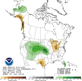
A wet July is forecast for the Central Plains west into the Rocky Mountains, as well as south Florida. Below average precipitation is expected in the Ohio Valley and central Great Lakes, as well as in south-central TX. For Memphis, odds favor near average rainfall, which historically averages just 2.88" in August, which is climatologically the driest month of the year.


----
Follow MWN on Facebook and Twitter for routine updates and the latest info!
Complete MWN Forecast: MemphisWeather.net on the mobile web or via the MWN mobile app
Download our iPhone or Android apps, featuring StormWatch+ severe weather alerts!
MWN is a NOAA Weather Ready Nation Ambassador Meteorologist Erik Proseus is an NWA Digital Seal Holder

Friday, August 2, 2019

Rain chances return just in time for the weekend

Happy Friday, and happy August! Current outlooks for this upcoming week have most of the Mid-South below average in terms of humidity along with heat indices, but rain chances will return once a front begins to push north up towards metro this weekend. No washouts expected, but some areas may see more rain than others. We are now getting closer and closer to the kiddos getting back to school, so it's time to make the most of these last few weekends of summer!


Friday


Still sticking to that average summer weather to begin your weekend, with partly cloudy skies and highs near 90. Dewpoints are luckily staying in the mid 60’s, so it’s still feeling a little humid out but not nearly as muggy as it was a couple of weeks ago. Northerly winds at 10 mph help to relieve that sticky feeling.

Friday morning satellite imagery shows cloudiness and rain to our west and southeast, but a sunny sky over the Mid-South.

Tonight


Overnight clouds will begin to clear out, bringing us clear skies and just a sliver of moonlight to light up outside. Lows in the lower 70’s, but some rural areas could possibly enter into the upper 60’s. NE winds at 4 mph.  

Saturday


Saturday is when the rain and thunderstorms return, with a front previously in Mississippi now beginning to push North. Partly sunny skies for most of the day however, and keeping those rain chances at only a 30%. Still staying warm with highs in the upper 80’s. Northerly winds at 7 mph. Overnight those clouds stick around, along with some of those rain chances. Lows in the lower 70’s, with still a consistent 30% chance of showers. 

The European model showing precipitation chances for the Mid-South Saturday morning until Monday evening with chances peaking during afternoon heating this weekend. (WxBell)

Sunday


Sunday is looking to be the wettest day in this week’s forecast, with a 40% chance of scattered showers and thunderstorms. The front that pushed north will hang out in the Mid-South and apparently just wanted to enjoy the weekend here! On the bright side, increased rain chances will also bring some slightly cooler weather with it with highs Sunday afternoon only warming into the mid 80’s. Rain chances linger into overnight and lows will drop into the lower 70’s. 

Monday

The NAM model showing possible rainfall amounts for the whole U.S. through this weekend. The Memphis metro could see 1/4-1/2" of rain, but some areas could see none, while others get more under a thunderstorm. (PivotalWeather)

The beginning of your work week will remain warm warm with highs near 90 and partly cloudy skies. After increased weekend humidity, it will be a bit more pleasant with the dewpoints in the mid 60’s. An isolated shower is possible, but a high pressure system is welcomed back into the Mid-South, suppressing rain chances from the weekend. Lows drop down near 70 overnight with clearing skies.

Tuesday


Aaaand just like that we are back to the same weather as today. Partly cloudy skies, a slight chance of afternoon thunderstorms, highs in the lower 90’s, and lows in the lower 70’s. This is all beginning to sound very familiar! It won’t stay that way for long though because the high pressure system suppressing rain chances will weaken a bit, allowing another cold front to approach the area by mid-week. 

August Outlook

NOAA's Climate Prediction Center released their August outlook for the U.S. this past week. It's looking like the Mid-South will be near average for late-summer in both the temperature and precipitation categories.

The Climate Prediction Center's August precipitation outlook indicates no clear signal for above or below precipitation in the Mid-South. (NOAA/CPC)


The Climate Prediction Center's August temperature outlook also indicates no clear signal for above or below temperatures in the Mid-South. (NOAA/CPC)

Jennifer LambersMWN Meteorologist Intern

----
Follow MWN on Facebook and Twitter for routine updates and the latest info!
Complete MWN Forecast: MemphisWeather.net on the mobile web or via the MWN mobile app
Download our iPhone or Android apps, featuring StormWatch+ severe weather alerts!
MWN is a NOAA Weather Ready Nation Ambassador Meteorologist Erik Proseus is an NWA Digital Seal Holder