Sunday through Tuesday
Sunday will feature nice weather with highs that top out in the low 60s with some cloud cover over the area. Sunday night temperatures will only get down to the mid 50s due to the increased cloud cover and small chance of a shower. Monday and Tuesday look to be our "rain-maker" this week. A slight chance of rain exists Sunday night. The high on Monday will be in the mid 60s, with rain chances increasing throughout the day. Monday night temperatures will drop quickly with the passage of a cold front as we could get all the way down to the upper 30s. Due to the passage of the cold front, temperatures will probably only max out in the low 40s with a cold rain falling. Tuesday night could be bitter cold with temperatures into the upper 20s. Even though we will likely get rain Monday through Tuesday, it doesn't look like totals will be that high, averaging less than a half inch.
 |
| The Quantitative Precipitation Forecast (QPF), or total rainfall, from late Saturday through late Tuesday, shows rain totals expected to be from one-quarter of an to half an inch . (WPC) |
Wednesday through Saturday
Wednesday through Saturday look like they will be dry and cold. These conditions will be present from Wednesday through Saturday because we will be under the influence of high pressure system. Wednesday highs will only top out in the mid 40s, with mostly sunny conditions. Wednesday night will get down to the upper 20s. Thursday highs will again only top out in the mid 40s with partly sunny conditions. Thursday night temperatures will drop to the low 30s. Friday temperatures during the day will top out in the upper 40s, with partly cloudy conditions. Friday night temperatures will drop to the mid 30s again. The high on Saturday will be pleasant with a high of about 50.
Glancing into Week Two
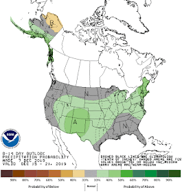
The weather conditions that will be present during week two (December 15th-21st) are most likely going to be near average, as shown by the Climate Prediction Center (CPC) below. Mid-month high temperatures average in the lower 50s with lows in the mid 30s.
 |
| CPC temperature map for the United States that shows temperatures will be around normal in the Mid-South. |
 |
| CPC precipitation map for the United States that shows precipitation will be around normal locally. |
MWN Meteorologist Intern
----
Follow MWN on Facebook and Twitter for routine updates and the latest info!
Complete MWN Forecast: MemphisWeather.net on the mobile web or via the MWN mobile app
Download our iPhone or Android apps, featuring StormWatch+ severe weather alerts!
 |  |
| MWN is a NOAA Weather Ready Nation Ambassador | Meteorologist Erik Proseus is an NWA Digital Seal Holder |


No comments:
Post a Comment