For most of last week we had rather sunny skies, with bearable temperatures. Unfortunately, as I'm writing this blog it looks like it'll be hot and steamy over the next week...that is until a potential tropical disturbance. From the end of this week, over the weekend, and into the beginning of next week it looks like it'll be hot and steamy before the remnants of Cristobal brings tropical moisture and rain to the area (primarily on Tuesday). After the remnants of Cristobal leaves the area it looks like conditions for the middle of June could be cooler and dry.
Thursday and Friday
Our chances of showers and thunderstorms will continue overnight into Thursday (50% chance). Temperatures will only drop to the lower 70s under mostly cloudy skies before our chance for showers and thunderstorms increase during the day and afternoon hours on Thursday (60% chance). Thursday will top out in the mid to upper 80s with winds coming from the southwest at about 10 mph. Luckily overnight into Friday chances for showers and thunderstorms will decrease slightly (to about 30%) as temperatures drop to the lower 70s again. During Friday, the shower and rain chances will stick with us (30% chance) as we reach a hot and humid high just below 90. Friday night into Saturday we will see temperatures drop into the lower 70s, under partly cloudy skies, and with a slight chance of rain (20% chance).
The reason we are seeing the shower and thunderstorm chances stick with us is due to a pesky upper level disturbance. This upper level disturbance brings with it some cyclonic vorticity (or counter-clockwise spin in the upper levels of the atmosphere), which leads to pressure falls, instability and sometimes active weather (such as showers and storms).
Saturday, Sunday, and Monday
Saturday and Sunday will mirror each other in almost every way. Both days look like they will top out in the lower 90s, with heat indices nearing 100 (HOT and HUMID!!!!). Sky conditions on both days will be partly cloudy to partly sunny, with very low rain chances. The overnight lows heading into Saturday and Sunday will drop to the lower 70s under some clouds. As we head into Monday temperatures will drop to the mid 70s under a mostly cloudy sky. Monday we have a chance of rain showers (30%) as we top out near 90 once again.
Tuesday and Wednesday (Cristobal)
Tropical Storm Cristobal has formed in the Bay of Campeche near southern Mexico and will sit down there for a couple days before moving north towards the Gulf Coast. It'll likely make landfall somewhere along the LA coastline late Sunday then continue north towards the Mid-South. Looks like it could be wet if you're headed to the AL/FL beaches to start next week. On Tuesday we might see the remnants of Tropical Storm Cristobal reach Memphis bringing with it tropical moisture, some soaking rain, and temps in the mid 80s. As of right now the European Model is predicting around 1" of rain, with the Weather Prediction Center (WPC) predicting 1-2" of rain. Overnight temperatures heading into Wednesday will drop to the mid 70s before a pleasant Wednesday arrives in the area. On Wednesday we will likely top out in the mid 80s under mostly sunny skies.
 |
| European model output showing rain totals for early next week. The model gives us around one inch of rain in the metro area as it tracks Cristobal through AR. (WxBell) |
 |
| This is how much rain is predicted to fall by the WPC late Monday into late Tuesday. Rain totals predicted by the WPC look to be between one and two inches. |
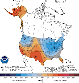
After the remnants of Cristobal pass during the first half of the week, the Climate Prediction Center (CPC) is predicting that temperatures will be more pleasant, possibly below normal. The CPC is also predicting that precipitation could be below normal, potentially making for a pleasant and dry period from June 11th-17th.
 |
| Temperature outlook provided by the CPC showing that temperatures in Memphis could be a little below normal from June 11th-17th. |
 |
| Precipitation outlook provided by the CPC showing that precipitation in Memphis could be a little below normal from June 11th-17th. |
Max Magness
MWN Meteorologist Intern
----
Follow MWN on Facebook and Twitter for routine updates and the latest info!
Complete MWN Forecast: MemphisWeather.net on the mobile web or via the MWN mobile app
Download our iPhone or Android apps, featuring StormWatch+ severe weather alerts!
 |  |
| MWN is a NOAA Weather Ready Nation Ambassador | Meteorologist Erik Proseus is an NWA Digital Seal Holder |


No comments:
Post a Comment