February Climate Recap
A cool January continued right into February, which can best be described as cold, wet, and memorable! Though there were a couple of short warm spells with highs in the 60s and 70s, the average temperature for the month was more than 2 degrees below normal, with low temperatures accounting for most of that deficit, averaging over 3.5 degrees below normal. There were two periods in particular during the month that were significantly below average - one that started with a generational ice storm, and another late in the month that had a bit of snow.
The "memorable" event is still in the cleanup stages as perhaps the most impactful ice storm since 1994 hit the city on the 3rd. Nearly 2" of liquid water fell with temperatures right at to just below freezing that day. Overall, most areas saw anywhere from 0.25" to 0.75" of ice accumulation and many reports of thunder-sleet at times as well. Tens of thousands of trees were damaged, leading to a massive cleanup effort that continues into mid-March. In addition, nearly a quarter million Memphis Light Gas and Water customers lost power, with the overall restoration effort taking a week and a half.
 |
| A birds-eye view of the city after the generational ice storm on February 3. Photo courtesy of The Daily Memphian/Patrick Lantrip. Used with permission. |
As of noon, over 100,000 @MLGW customers are without power, and limbs and lines are still falling. Please stay away from downed lines and exercise caution walking around ice laden trees! #memice pic.twitter.com/9QGa6KjGO5
— MemphisWeather.net (@memphisweather1) February 3, 2022
In addition to heavy precipitation early in the month, thunderstorms also dropped an inch of rain on the 17th and produced additional widely scattered tree damage due to wind, then another very wet week occurred starting on the 22nd with over 4.5" of rain falling through the 27th. Despite being the shortest month, it certainly provided plenty of impactful weather events!
Memphis International Airport, Memphis, TN
Temperature
Average temperature: 44.0 degrees (2.1 degrees below average)
Average high temperature: 54.9 degrees (0.6 degrees below average)
Average low temperature: 33.0 degrees (3.7 degrees below average)
Warmest temperature: 75 degrees (16th)
Coolest temperature: 22 degrees (4th, 5th, 6th)
Heating Degrees Days: 582 (50 above average)
Cooling Degree Days: 0 (2 below average)
Records set or tied: None
Comments: 14 days saw temperatures fall below freezing which is 4 above average
Precipitation
Monthly total: 8.02" (3.47 " above average)
Days with measurable precipitation: 10 (0.1 days above average)
Wettest 24-hour period: 2.31" (23rd-24th)
Snowfall: Trace (1.0" below average)
Records set or tied: Tied record daily snowfall - Trace (23rd)
Comments: A trace of snow was recorded on the 3rd, 4th, and 23rd. 0.71" of freezing rain accumulated on the 3rd.
Miscellaneous
Peak wind: Southwest/49 mph (17th)
Average wind: 9.0 mph
Average relative humidity: 64%
Average sky cover: 50%
Click here for a daily statistical recap for Memphis International Airport.
Cirrus Weather Solutions / MemphisWeather.net, Bartlett, TN
Temperature
Average temperature: 42.3 degrees
Average high temperature: 54.2 degrees
Average low temperature: 30.6 degrees
Warmest temperature: 72.8 degrees (11th)
Coolest temperature: 17.6 degrees (5th)
Comments: None
Precipitation
Monthly total: 7.14" (automated rain gauge), 8.40"(manual CoCoRaHS rain gauge)
Days with measurable precipitation: 9
Wettest date: 2.03" (22nd) (via automated gauge)
Snowfall: Trace
Comments: 0.3" of freezing rain on the 3rd. Traces of snow occurred on the 3rd and 4th.
Miscellaneous
Peak wind: South to southwest/29 mph (16th & 17th)
Average relative humidity: 71%
Average barometric pressure: 30.22 in. Hg
Click here for a daily statistical recap for Bartlett, TN.
Comments: None
MWN Forecast Accuracy
MWN average temperature error: 2.80 degrees
MWN forecast temperatures within 2 degrees of actual: 52%
MWN average dewpoint error: 2.77 degrees
MWN forecast dewpoints within 2 degrees of actual: 53%
MWN's forecasts extend out five periods (2.5 days, or roughly 60 hours). Historical accuracy statistics can be found here.
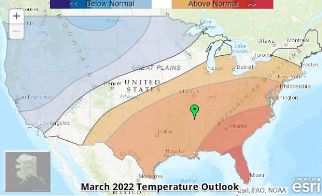
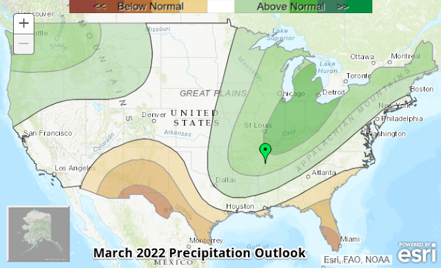
Climate Outlook - March 2022
The March climate outlook for the United States from the Climate Prediction Center is shown below. Above average temperatures are forecast for a large area from the Mid-Atlantic through the Ohio River Valley and southeast U.S. into the south-central U.S with strongest chances in the Deep South and Florida. Below average temperatures are expected across the Northern Rockies and west coast. Odds favor above average temperatures (46%) for Memphis over the course of the month versus a 22% chance of below average temperatures. The average temperature for March is 54.2 degrees.
Precipitation is expected to be above normal from the Northeast U.S. into the Midwest and south through the Mississippi River Valley, as well as the Pacific Northwest. Highest odds of wet conditions are in the Great Lakes and Ohio Valley. Below average precipitation is forecast for the Rio Grande Valley into the Desert Southwest, as well as in Florida. For Memphis, odds favor above average precipitation (46%) versus a 21% chance of below average precipitation, which historically averages 5.74 inches in March.
---
Complete MWN Forecast: MemphisWeather.net on the mobile web or via the MWN mobile app
Download our iPhone or Android apps, featuring StormWatch+ severe weather alerts!
 |  |
| MWN is a NOAA Weather Ready Nation Ambassador | Meteorologist Erik Proseus is an NWA Digital Seal Holder |


No comments:
Post a Comment