Overall, it appears most of the area made it through Wednesday's Level 4 severe weather risk pretty well, thank goodness! Outside of a funnel cloud over West Memphis, stealthily captured on video from a vantage point on Mud Island by Jordan Booth, no there were no tornado sightings or damage locally.
@memphisweather1 looking across to west Memphis pic.twitter.com/g2y7L1eN89
— Jordan booth (@jbooth0722) April 13, 2022
The biggest problem seemed to be very heavy rainfall that caused minor flooding issues around the area. Thursday was a welcome respite from the storms with clear blue skies and low humidity. Unfortunately, the pattern changes quickly this time of year!
For those hoping for a delightfully warm and sunny Easter weekend, Mother Nature has other plans. The good news is I don't expect a washout of a weekend, and not a lot of severe storms. The tougher news is that many of our activities - including Easter egg hunts, proms, Sunday morning worship services, and Grizzlies playoff parties on the FedExForum plaza - might have to deal with some rain. Let's talk it through....
Friday into Friday Night: storms arrive
Clouds increase today as high pressure has shifted to our east and southerly wind becomes re-established. That also means an increase in moisture and building rain chances, especially by this evening, though a couple spotty showers are possible this afternoon. Look for highs to reach the mid 70s after a cool start to the day.
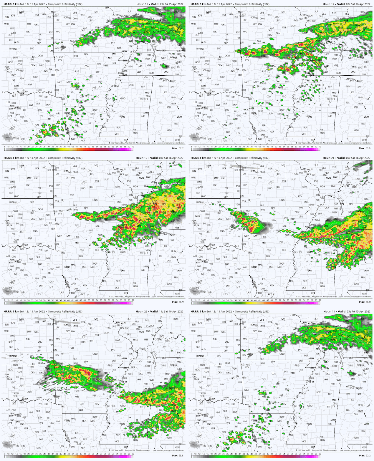
By tonight, we'll be involved in a "squeeze play" as a warm front pushes north from the deep south and a cold front advances into Arkansas from the north. Once the warm front arrives, showers and thunderstorms will become likely. In addition, some thunderstorms forming ahead of the cold front in northern AR will move southeast into our area. All of this means rain chances increase this evening and it is likely to be a wet overnight period with periods of thunderstorms to wake the kids and dog. I expect the highest probability of some storms will be from around midnight through the wee hours of the morning.
 |
| The HRRR model forecast radar loop from 6pm Friday through 6am Saturday shows showers and thunderstorms moving through the Memphis area much of the night. (WeatherBell) |
As for severe weather, we are in a Slight Risk (level 2 of 5) for scattered strong to severe storms. Main threats are large hail, strong wind gusts, and heavy rainfall. I really am not concerned about tornadoes tonight and the better chance of severe storms is to our west in the Ozarks and central AR, however some storms in the wee hours of Saturday morning could produce hail stones and strong wind gusts. Flooding could become a concern in spots as rainfall will likely be "efficient" owing to a very saturated airmass overhead and thunderstorms dropping heavy rain. The sinking cold front will overtake the lifting warm front and push south through the metro by sun-up Saturday, bringing the thunderstorm chances to an end. However, the front looks to stall over central MS, which brings us to the rest of the weekend...
.png) |
| A Level 2 (Slight) Risk of severe storms is forecast for Friday night. (NOAA/SPC) |
Saturday: Easter eggs, NBA playoffs, proms, and rain showers
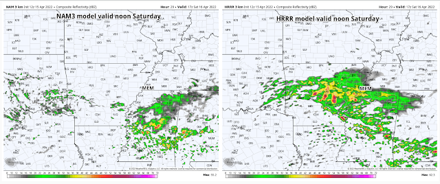
With the cold front to our south, but not too far away, I expect a cloudy day with mild temperatures and a northeast wind. We should stay in the 60s most of the day. We also will likely be dodging rain showers off and on. Model data has been inconsistent on the most likely timing, even the "good" high-resolution model runs this morning. While lingering showers are possible early in the day behind the front, upper level energy could also prompt some showers throughout the day. The normally reliable HRRR model says more wet than dry hours during the day Saturday, while the also very good NAM3 model thinks most of the daytime will be dry. Take your umbrella.
 |
| Comparison of "future radar" from two well-respected models for noon Saturday. #shrug |
The good news here is that with northeast wind and the front to the south, thunderstorms should be few and far between. Saturday night looks to continue the trend with additional chances for rain showers throughout the night, as well as chilly conditions with lows dropping below 50 by the time any Easter Sunrise services start early Sunday morning, while leads us to Easter Day...
Easter Sunday: rain chances continue
Unfortunately, Easter Sunday may not bring excellent opportunities for family photos in your Sunday best, at least outside with the azaleas. Overnight rain chances will likely continue into the morning hours. If there's a dry period Sunday, it could be late morning through mid-afternoon, because by late afternoon and evening, one more wave of moisture production arrives as a reinforcing cold front moves through. I can't rule out some thunderstorm activity late Sunday afternoon and evening with the front, but severe weather chances look slim to none. All of that activity moves out Sunday night though. As for temperatures, it'll be cool Sunday. Starting in the upper 40s, we'll only see temperatures top out in the lower 60s, or about 10 degrees below average.
 |
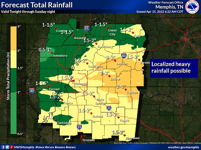
| Rainfall totals for Easter weekend will likely be close to 2" total, more to the east of the city and less to the west. Keep the umbrella handy! (NWS-Memphis) |
Next week: mostly dry and warming by mid-week
Behind this weekend's systems, we finally look to catch a multi-day break from rain and storms, though below average temperatures continue. Generally, expect sunny skies Monday and Tuesday with lows in the 40s and highs in the mid 60s. Clouds increase Wednesday leading to a minor chance of rain Thursday, though it looks like it might stay to our west as warmer high pressure builds over the southeast U.S. and temperatures climb back into the 70s for highs mid to late week.
MWN Meteorologist
----
Follow MWN on Facebook and Twitter for routine updates and the latest info!
Complete MWN Forecast: MemphisWeather.net on the mobile web or via the MWN mobile app
Download our iPhone or Android apps, featuring StormWatch+ severe weather alerts!
 |  |
| MWN is a NOAA Weather Ready Nation Ambassador | Meteorologist Erik Proseus is an NWA Digital Seal Holder |

.gif)
No comments:
Post a Comment