Saturday, August 20, 2022

Changes ongoing and upcoming at MemphisWeather.net!

A lot has been going on behind the scenes this year for MemphisWeather.net. While most changes take place "under the hood," some will manifest themselves to our followers and friends over the coming few months. We thought it would be a good time to shine the light on a few of them:

Staff addition to Cirrus Weather

For at least a few years, I've been keeping my eyes open for the right person to help expand the MWN offerings, grow the brand, and honestly, take a bit of the load off once in a while, especially during active weather periods. In the fall of 2020, I brought on a friend and local meteorologist in a contracting role to write a few blog posts, cover inclement weather for MWN occasionally, and help maintain the StormWatch+ brand. The "trial period" was highly successful and this past spring, our business relationship was formalized. Meteorologist Richard Hoseney joined me as co-owner of Cirrus Weather Solutions, LLC!

Richard was born and raised in the Mid-South, and has always been a fan of the weather since getting involved with Storm Spotter training from the NWS here in Memphis.  He attended Mississippi State and earned his Bachelor's Degree in Meteorology in 2005, interning back in 2003 at FOX 13 with Jim Jaggers.  He chased some prominent hurricanes too! Richard was in Gulfport during Hurricane Katrina, in Orange (Texas) during Hurricane Rita, and in Pascagoula during Hurricane Ivan.  

After graduating, he met his wife who is originally from eastern Oklahoma.  They moved to Oklahoma where Richard worked at a locally-owned radio group as their staff meteorologist, covering everything from severe weather to ice storms to flooding, and formed a partnership with the county's Emergency Management in assisting the storm spotters during severe weather.  While in Oklahoma, Richard got into aviation, obtaining his private pilot certificate and his own plane. (And now he pilots #MWNDrone1 as well!)  In 2018, Richard and his wife moved back to the Mid-South after accepting a job as a meteorologist at FedEx.  He loves the Mid-South and enjoys forecasting the weather, especially severe weather. Richard has been actively working on several projects to improve the services offered by MWN over the past few months. You'll be seeing more of the fruits of his labor soon! Speaking of which...

MWN Live Streams

One of the projects Richard has taken on that we think you all will benefit greatly from is the addition of severe weather live streams via YouTube. We've been tweaking the software setup and training behind the scenes in order to begin offering you the opportunity to "look over our shoulder" and see detailed views of radar and other tools we use during severe weather. There will also be a live chat where you can ask us questions and get explanations on what you see out your window, or just over the horizon! We might even bring on one of our meteorology student interns at times to help out! 


Our goal is to enhance MWN's content in a way that provides real-time updates for the storms affecting YOU. We'll basically be making our hyperlocal, no-hype coverage more widely available - via your mobile device or even your smart TV! And it will be done with no ads, no fees, and no preempting your favorite shows. We'll let everyone know via our Facebook and Twitter feeds when we start a broadcast, but the best way to find out is to subscribe to our YouTube channel then click the bell for notifications when we go live! Be watching for a debut broadcast soon!

Changes to the Cirrus Weather app offerings

A significant shift has taken place over the past year in our mobile app sector. Most of you are aware that we offer two mobile apps - MemphisWeather.net and StormWatch+. These apps (including Android and iOS versions of each) have been the work of a single app developer since their inception over 10 years ago. Our "app guy" is unbelievably smart. He has shown his dedication to all of you for a decade and receives all of the credit for your ability to get your daily dose of MWN, and also to receive valuable severe weather alerts that ensure your safety and sanity. We are eternally grateful for his tireless and dedicated efforts. 

But maintaining what is effectively four apps was becoming a challenge, so we mutually agreed to move in new directions. Fortunately, after searching for just the right match, we are excited to have secured a new development firm based in our home state of Tennessee, Rise Above Creative! This transition will mean a change in our mobile app offerings though (which, to be honest, was the path we were headed down anyway).

The StormWatch+ app is currently being rebuilt from the ground up in an easier-to-maintain format. Once it is "re-launched" in a couple months, we will be integrating your trusted MWN content into the StormWatch+ app. This will simplify things for us significantly, while still allowing us to provide the most-used content from MWN in app form. In addition, you'll gain access to reliable nationwide weather information that some of you have been asking for in the MWN app, as well as maintaining the super-fast and pinpoint-accurate SW+ Alerts severe weather notifications that many of you already use in either the MWN or StormWatch+ apps. As always, all of this will be available without a single advertisement in the app and with a tight grip on your personal data!


We'll be communicating further as the transition time nears, but for right now, there is nothing you need to do. We look forward to a streamlined experience for our app users and getting all of the information you need in a one-stop shop!

That's the gist of it! We hope these changes and additions are well-received, and we always appreciate your support as well as your inquiries. We would appreciate you taking a minute to hop over to our YouTube page and clicking subscribe (then don't forget to click the bell!), and we'll keep you posted on app updates as they draw near!

----
Follow MWN on Facebook and Twitter for routine updates and the latest info!
Complete MWN Forecast: MemphisWeather.net on the mobile web or via the MWN mobile app
Download our iPhone or Android apps, featuring StormWatch+ severe weather alerts!
MWN is a NOAA Weather Ready Nation Ambassador Meteorologist Erik Proseus is an NWA Digital Seal Holder

A weather "squeeze play" this weekend, then near average conditions for the coming week

The overall weather pattern has become more favorable for drought and heat relief over the past couple of weeks, with improvements in both categories following a brutal June, July, and early August. So far this month, the average temperature has been over four degrees cooler than July, and yet we're still slightly above the typical August average. (That says more about July than it does August.) 

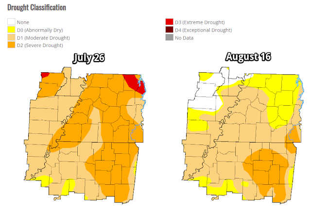
Rainfall the past few weeks has also put a dent in the drought. Below are the drought index maps from late July and this week. We still have a ways to go, particularly getting wet conditions deeper into the soil, but it's improving and what we see above ground is in much better shape than it was a few weeks ago!

Comparison of the drought maps for late July and mid-August show significant improvement in northeast AR and some decent improvement along the Mississippi River and west TN as well. (U.S. Drought Monitor)

Saturday-Monday: a weather "squeeze play"

A couple of frontal systems will play into how the weather evolves over the next 48-72 hours, which probably isn't ideal if you are looking for a completely dry and sunny weekend! Although we're not expecting any washouts, rain chances will be elevated, especially on Sunday.

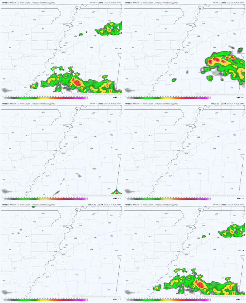
A warm front to our south on Saturday morning is lifting north, bringing scattered showers and thunderstorms to north MS this morning, spreading northeast. Additional pop-up showers and storms are possible across the metro this afternoon. While models aren't indicating a great deal of rain, we could see a little "whack-a-mole" on the radar throughout the day. In general, clouds will increase and dewpoints will slowly tick up into the low 70s on a southwest breeze as well. Look for highs near or just above 90 degrees. Overall coverage of cells will diminish to isolated overnight, so if you have tickets for Live at the Garden or other activities outdoors this evening, it's not likely to be wet.

The morning HRRR model shows thunderstorms over north MS moving northeast and largely missing the metro. While it stays mainly dry after that, we can't rule out a few showers or t'storms popping up briefly this afternoon. (WeatherBell)

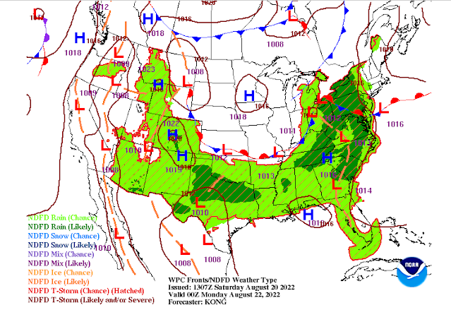
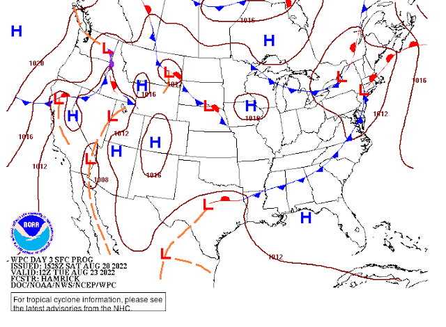
Meanwhile, to our north, a cold front is also inching south from the Ohio River Valley and Missouri. It will approach on Sunday as the warm front lingers over the area. This combination will provide our best chances of rain maybe for the coming week. Once again, it won't be a washout, but chances are probably higher than 50/50 that you will get at least some rain tomorrow, and thunderstorms are also possible, especially in the afternoon. Wea re not outlooked for severe weather, so the chances of strong wind and hail are minimal, but the lightning threat will need to be monitored if you plan to be outdoors. We'll probably have a "Pool Alert" at some point! Southwest wind will continue to feed the moisture into the area, so highs near 87 could be a bit uncomfortable in the muggy air. Rainfall should generally be a half inch or under for most, though some heavier cells could drop up to an inch. Rain chances wind down some, though not zeroed out, Sunday night with the cold front dropping over the metro.

The surface weather map for Sunday evening shows a cold front just to our north, while the warm front to the south is largely dissipated. Scattered showers and storms will be possible Sunday. (NWS/WPC)

By Monday, the cold front/warm front mash-up will be along the I-40 corridor and slowly continuing to ooze south. We'll see wind shift to the west with mostly cloudy skies. Rain chances continue, but at a bit lower level (30% or so), and the best chance will be in the afternoon over north MS ahead of said frontal boundary. Highs will remain in the mid 80s and there will still be some sticky air, but high dewpoints should start to retreat a bit as the front eases southward. 

The cold front, by Tuesday morning, will be well to our south, ensuring drier conditions and less humid air heading into the mid-week period. (NWS/WPC)

Rest of the week: fairly average for August

With the front pushing into north MS, rain chances should diminish even further for the mid-week time period. We're looking at partly cloudy skies, not-intolerable humidity levels, and high temperatures near 90 degrees, which is average for this time of year. With dewpoints suppressed a bit, there will be no big heat index issues and morning lows will probably drop into the upper 60s outside the city while remaining near 70 in the urban jungle. 

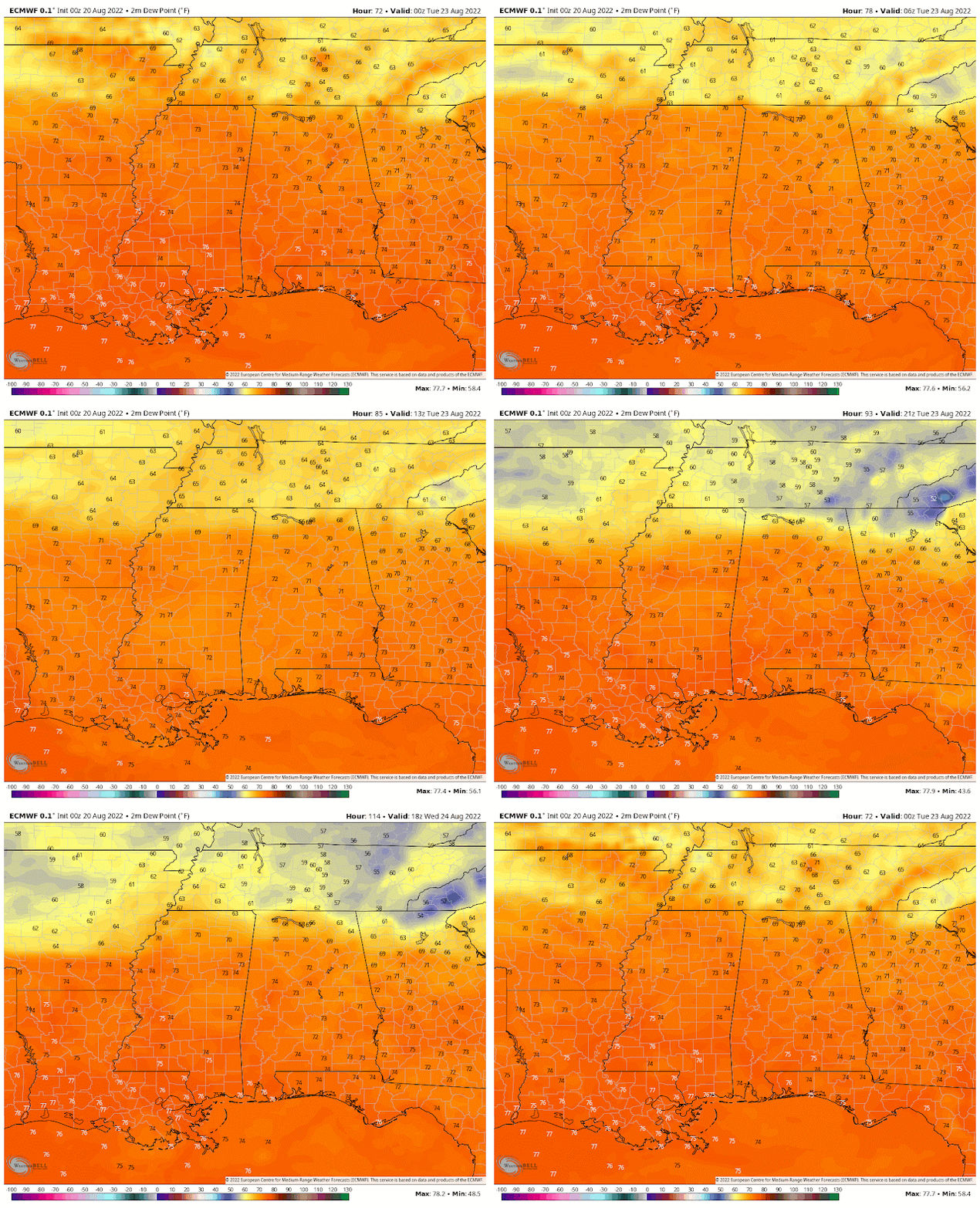
Forecast dewpoints from the European model for the period between Monday evening and Wednesday evening clearly show tropical moisture (oranges, dewpoints in the 70s) just to our south across the southeast states, but drier air (yellows, dewpoints in the 60s) just to the north, including the Memphis metro. We're on the good side of that moisture boundary! (WeatherBell)

There are hints from some mid-range model data that we could get a return of the front to our south by late in the week, which might bring a few heat-of-the-day thunderstorms on Thursday and Friday. Other solutions indicate that it will stay dry with high pressure strengthening aloft. It does appear that temperatures could tick up just a bit towards next weekend, so lower 90s during the day and lower 70s in the early mornings seems to be where temps will fall. 

To recap: scattered rain chances the next couple days, highest on Sunday, with slightly below average temperatures Sunday and Monday. Then mainly dry for much of the week ahead with temperatures returning to near average. It appears that August will indeed go down as a "cooler" month than July was. And for that, our utility budgets are appreciative!

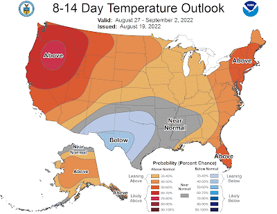
The temperature outlook for the last week of August favors near normal temperatures for our area, while the west and east bake. Excessive moisture and rain chances result in cooler than average conditions in the south-central portion of the country. (NWS/CPC)


Erik Proseus
MWN Meteorologist

----
Follow MWN on Facebook and Twitter for routine updates and the latest info!
Complete MWN Forecast: MemphisWeather.net on the mobile web or via the MWN mobile app
Download our iPhone or Android apps, featuring StormWatch+ severe weather alerts!
MWN is a NOAA Weather Ready Nation Ambassador Meteorologist Erik Proseus is an NWA Digital Seal Holder

Saturday, August 6, 2022

July 2022 Climate Report for Memphis, TN

July Climate Recap

Heat was the story in the month of July as the hot and dry pattern from the second half of June blasted right through the calendar change and continued for nearly the entire month. Only four days failed to reach a high of at least 95 and three were the final three days of the month. The century mark was reached or exceeded ten times during the month (third most on record) with a max of 103 on two occasions. The low temperatures remained above 70 degrees for the entire month and only dropped below 74 once, a feat that has only occurred one other time in recorded history (2011). 

In sum, the month ended well above average temperature-wise (second warmest on record behind 1980). The average high temperature was third warmest on record and the average low temperature was second warmest on record. For the period June 1 through July 31, the average temperature in Memphis was the hottest on record at 85.2 degrees.


Drought conditions that began in June worsened considerably through the first few weeks of July with the persistent heat and lack of widespread precipitation, resulting in a large portion of the metro in "severe drought" as we approached the end of the July. When rain did fall, it tended to be fairly localized and heavy, resulting in local relief from dry conditions, but little relief over the entire area until we neared the end of the month. Reflective of the mainly localized nature of the storms, the rain gauge at MWN in northern Shelby County received almost three more inches of rain than the airport. Over 50 percent of the rain that fell for the month at the official observing site occurred in the last three days of the month and much of the rest fell on the 18th. Flood Advisories during those two events were the only weather alerts issued by the National Weather Service for the metro in July.

Comparison of the Drought Index from the middle of June to the end of July shows the results of  the very dry pattern experienced for much of the last two months. (U.S. Drought Monitor)


Memphis International Airport, Memphis, TN

Temperature 
Average temperature: 87.1 degrees (4.3 degrees above average) 
Average high temperature: 97.1 degrees (5.2 degrees above average) 
Average low temperature: 77.2 degrees (3.6 degrees above average) 
Warmest temperature: 103 degrees (5th, 8th) 
Coolest temperature: 71 degrees (18th) 
Heating Degrees Days: 0 (0.0 above average)
Cooling Degree Days: 693 (143 above average) 
Records set or tied: Daily high temperature records were set or tied on the 7th (101 - tied) and 8th (103), while record warm minimum temperatures were set on the 5th (80) and 20th (82).
Comments: 29 days saw high temperatures meet or exceed 90 degrees, which is 6.9 above normal. Ten days met or exceeded 100 degrees, ranking third behind 1980 (19) and 1954 (11). The average temperature for the month placed July second warmest on record behind 1980. The average high temperature was third warmest on record and the average low temperature was second warmest on record.

Precipitation 
Monthly total: 4.24" (0.58" below average) 
Days with measurable precipitation: 9 (0.5 days below average) 
Wettest 24-hour period: 1.50" (31st) 
Snowfall: 0.0"
Records set or tied: None
Comments: None 

Miscellaneous 
Peak wind: Northeast/35 mph (17th) 
Average wind: 7.5 mph 
Average relative humidity: 63%
Average sky cover: 47%

 Click here for a daily statistical recap for Memphis International Airport.
 

Cirrus Weather Solutions / MemphisWeather.net, Bartlett, TN

Temperature 
Average temperature: 84.0 degrees 
Average high temperature: 94.8 degrees 
Average low temperature: 74.5 degrees 
Warmest temperature: 101.0 degrees (8th) 
Coolest temperature: 64.7 degrees (11th) 
Comments: None 

Precipitation 
Monthly total: 6.91" (automated rain gauge), 7.08"(manual CoCoRaHS rain gauge) 
Days with measurable precipitation: 8
Wettest date: 2.12" (1st) (via automated gauge) 
Snowfall: 0.0"
Comments: None

Miscellaneous 
Peak wind: Northeast/28 mph (17th)
Average relative humidity: 72% 
Average barometric pressure: 29.97 in. Hg
Comments: None

Click here for a daily statistical recap for Bartlett, TN.
 

MWN Forecast Accuracy

MWN average temperature error: 1.81 degrees 
MWN forecast temperatures within 2 degrees of actual: 73% 
MWN average dewpoint error: 1.86 degrees 
MWN forecast dewpoints within 2 degrees of actual: 72% 

MWN's forecasts extend out five periods (2.5 days, or roughly 60 hours). Historical accuracy statistics can be found here.

--- 
Follow MWN on Facebook and Twitter for routine updates and the latest info! 
Complete MWN Forecast: MemphisWeather.net on the mobile web or via the MWN mobile app 
Download our iPhone or Android apps, featuring StormWatch+ severe weather alerts!
MWN is a NOAA Weather Ready Nation Ambassador Meteorologist Erik Proseus is an NWA Digital Seal Holder