The Thanksgiving holiday has been somewhat dreary and damp, and definitely cloudy, thanks to a slowly-lumbering upper level low that passed nearby. As that 800-lb gorilla moseys away, a much more dynamic atmospheric setup will move through the Mississippi Valley early this week - one that poses a level of severe weather risk that we have not seen in some time. These late-season severe patterns can be tricky, but also quite potent when they do come into form. (Some may remember or have heard of the Thanksgiving weekend Germantown EF-3 tornado that occurred nearly 30 years ago. Tornadoes in the cool season are definitely possible in the Mid-South.) This one will definitely bear watching, and require your attention and preparation.
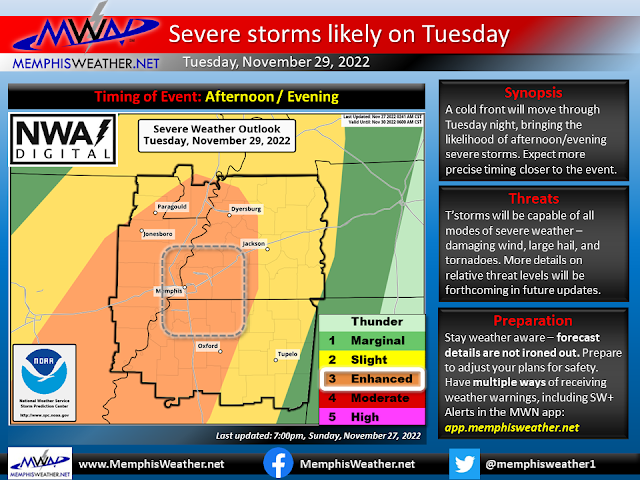
Tuesday is the day of concern. While this event is still 48+ hours out, some atmospheric parameters are coming into place and others are still unknown, and as usual there are also a few potential flies in the ointment. Currently, the Memphis metro is in an "Enhanced Risk" of severe weather, or level 3 out of 5, according to the severe weather experts at the National Weather Service. Let's run through the scenario.
What we know: an upper level jet stream blowing at over 150 mph will be screaming overhead from the west-southwest, ahead of a strong upper level trough (lower pressures) moving east across the Plains. Also, very strong wind at the low and mid levels also appears to be a given (50+ mph at about 2000 feet and gusts to 30 mph at the surface, blowing from the south). That means that we have one key ingredient: wind shear. There also will be a lifting mechanism to get air rising - producing the convective process to initiate thunderstorms: an approaching cold front, and perhaps a pre-frontal surface trough. In addition, moisture will be abundant is well-above-average surface dewpoints in the lower, to possibly mid, 60s are expected.
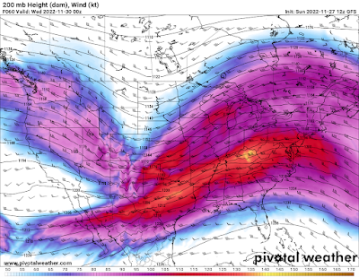 |
| The jet stream will be strong (150 mph wind), and basically directly overhead, by 6pm Tuesday. (GFS model, Sunday 12Z) |
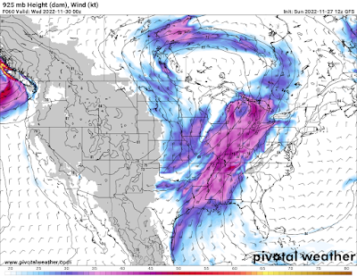 |
| A low level jet stream will also be quite strong and overhead early Tuesday evening, topping out above 50 mph. (GFS model, 12Z Sunday) |
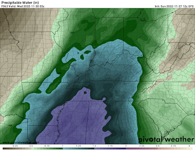 |
| Atmospheric moisture, as measured by precipitable water (PW) at 9pm Tuesday is forecast to be well above average, or nearly 1.5" (GFS model, 12Z Sunday) |
What is not quite as certain: the amount of "storm food," or fuel, that is needed to keep air rising once it is lifted, and thus tap into the abundance wind shear. In the cool season, it doesn't take nearly as much instability to generate severe weather as it is often compensated for by an abundance of wind shear, which will be the case this time. It does take SOME instability though, and how much we will have is a big question mark. Models are all over the place, and tend to under-forecast this parameter a few days out. I'm betting we'll have enough to generate strong storms, and if they can become strong, they will certainly have the potential to be severe.
How it might play out: I expect that we'll see some daytime "elevated" thunderstorms, mainly in the afternoon hours, as an initial push of moisture and mid-level instability arrives on gusty south wind, as dewpoints climb into the 60s. These could have the potential to produce some gusty wind and large hail, as well as localized downpours.
By late afternoon, and more likely during the evening, the more potent atmosphere appears to move in as surface-based instability rises (again, we don't know how much). While it is possible that there will be fewer echoes on radar after sunset than during the afternoon, the potential for them to be strong to severe will be heightened. Rotating storms are entirely possible, and thus we have a potential for large hail, damaging wind gusts, and even a few tornadoes, which could be strong. Late in the night, the cold front itself arrives, so the storm threat continues overnight. It's a bit more uncertain how those could behave. We may have to wait and see how the day unfolds to know for sure.
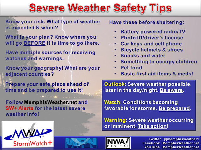
Bottom line: all Mid-Southerners need to be preparing now for the potential for severe storms, capable of large hail, damaging wind, and tornadoes, from Tuesday afternoon into Tuesday night. Secure items outdoors that you want to keep, plan to garage vehicles as able on Tuesday, and stay tuned to additional details that will help you plan your activities for the day. As of right now, Tuesday evening is my greatest concern. If you have flexible plans, go ahead and adjust now. By all means, STAY IN TOUCH with your trusted weather sources as details are likely to change in the next 48 hours, and have multiple methods of receiving severe weather alerts prepared in case they are needed Tuesday.
MWN Meteorologist
----
Follow MWN on Facebook and Twitter for routine updates and the latest info!
Complete MWN Forecast: MemphisWeather.net on the mobile web or via the MWN mobile app
Download our iPhone or Android apps, featuring StormWatch+ severe weather alerts!
 |  |
| MWN is a NOAA Weather Ready Nation Ambassador | Meteorologist Erik Proseus is an NWA Digital Seal Holder |


No comments:
Post a Comment