First half of December wet and warm
We have dealt with almost two solid weeks of cloud cover, periods of fog, and multiple rainy systems and thunderstorms to start December. The result was 4-6" of rain, saturated ground, and a bunch of Mid-Southerners fighting Season Affective Disorder (making us feel SAD heading into the Christmas season)! Despite all this damp weather, the Drought Index valid this past Tuesday is a bit discouraging:
I expect we'll see improvement in next week's edition as it tends to lag actual conditions just a bit. But it is also proof that it takes prolonged wet weather to dig out from under a long-term drought! I suspect if you were to try and dig a hole in your yard, you would have some trouble once you get below the top 2-4"! That is drought -- not the standing water on top of the yard!
For the first two weeks of December, despite feeling cool and damp, the average temperature is actually 6.8° above normal! That is driven by both above average highs and lows, but low temperatures in particular have been quite warm for December thanks to all the cloud cover keeping us from dropping anywhere close to freezing since the 1st. That will change quickly now following yesterday's cold front. Readings near 60° are over for the month!
Second half of December brings the chill
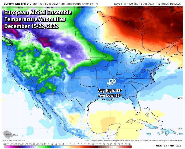
A large dome of Arctic air has dropped across much of the eastern 2/3 of the nation, resulting in high temperatures locally in the 40s for the next week. We'll also get down to freezing nearly every morning for the next week. High pressure will control the weather for the majority of this time period resulting in mostly sunny skies. A cold front on Monday looked to potentially bring some precipitation, but it is starting to look like it may not be able to tap into enough moisture in the air to produce more than clouds, drying out as it approaches us Monday. If very light precip were to occur, it would likely be rain.
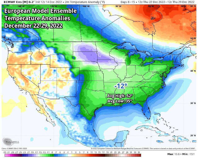
Behind that front, we'll have a couple more dry and cool days before a massive shot of polar air that will dive into the central U.S. will shove its way southeast into the Mid-South. While the next week will be chilly, the airmass arriving late next week promises to be #StupidCold, just in time for Christmas weekend. Early indications are that we may not rise above freezing for a few days over the Christmas holiday with wind chills probably into the single digits! As for precipitation....
Maybe?!
With all the usual caveats - it's a week out, it's the Mid-South, we have bluffs and I-40 (kidding!!) - the front will be potent enough that it could definitely generate precipitation, probably on Thursday the 22nd.
 |
| Weather forecast map valid Thursday morning, Dec. 22. Polar air dropping through the central U.S. reaches the Mid-South with the potential for a quick shot of snow along the front. (NWS) |
Factors that will have to be considered: timing (of the day) and near-surface temperatures, available moisture, system dynamics, etc. One negative factor to a potentially "good" snowfall is the speed of this system. The polar airmass will hit quickly and with a fury. Precipitation won't linger around as the very dry air behind the front quickly shuts precipitation off. Long-range models are not super helpful right now, but the ensembles of those models (which we use at longer ranges to detect trends, not details) are hinting at a quick shot of snow with the front. The MWN Forecast carries a chance of rain and snow on Thursday. We'll keep you posted as we get closer! What you should prepare for though is bitterly cold air for Christmas weekend!
Erik Proseus
MWN Meteorologist----
Follow MWN on Facebook and Twitter for routine updates and the latest info!
Complete MWN Forecast: MemphisWeather.net on the mobile web or via the MWN mobile app
Download our iPhone or Android apps, featuring StormWatch+ severe weather alerts!
 |  |
| MWN is a NOAA Weather Ready Nation Ambassador | Meteorologist Erik Proseus is an NWA Digital Seal Holder |


No comments:
Post a Comment