Pages

Saturday, December 31, 2022

Return of warmth brings a risk of severe storms, and a few words to close out 2022

Another year with overall above average temperatures and precipitation is wrapping up, though this month will end up slightly cooler than average, but marked by large temperature swings. It's also been wet this month with nearly 6 inches of rain. The major cold spell that marked the days leading up to and through the Christmas weekend has reversed course, with well above average temperatures the past couple of days, which will lead us right into 2023. Of course, 60s at this time of year means we need to keep an eye on the potential for storms as the pattern changes once again!

Ringing in 2023 with warm air

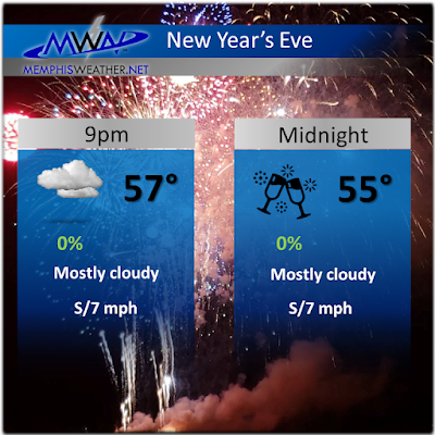
As for the New Year's weekend, you really can't ask for much better, particularly for outdoor celebrations, as temperatures will be in the 60s today and Sunday during the day and in the 50s overnight. In addition, rain chances are basically nil, so grab the light jacket if you are headed out tonight and enjoy your time responsibly! Despite a lack of rain, lots of clouds will mark the sky condition with maybe some afternoon peeks of sunshine later this afternoon and again Sunday afternoon. 


As we head into the first Monday of 2023, the next major trough of low pressure starts to approach the area and precipitation chances ramp up as gusty south wind brings in even more humid air, forcing temperatures towards the 70 degree mark. Best chances of rain Monday are in the afternoon and scattered thunderstorms will be possible as a warm front moves through the area. A couple of these could be strong with a few strong wind gusts and small hail, but the warm front itself will escort in an airmass with a bit more instability that sets the stage for overnight storms.

An early look at forecast radar for Monday afternoon from the high-res NAM model shows the potential for a batch of storms to move through with a warm front. This is NOT the most likely time for severe weather, which would be during the wee morning hours on Tuesday. (WeatherBell)

Severe weather potential Monday night

Monday night is the most likely time for severe weather, as storm chances increase late in the night. However, the trend today versus yesterday is for a slightly lower chance of severe storms in our area. To our southwest though, severe storms containing high wind and a few tornadoes appear likely from east TX into LA and the southern half of AR. Nonetheless, heavy rain and thunderstorms are likely overnight locally, and probably late at night (after midnight) as the system moves east. Due to more uncertain severe weather parameters, including instability levels and stronger upper level dynamics, the chance for severe weather in the Memphis area currently sits in the level 1-2 range (Marginal to Slight Risk). The storms could produce a few strong to severe wind gusts, as well as copious lightning and periods of heavy rain that could result in minor flooding with saturated soil and a couple of inches of rain expected. Stay abreast of this situation for later updates as details are still to be refined and our risk could increase.
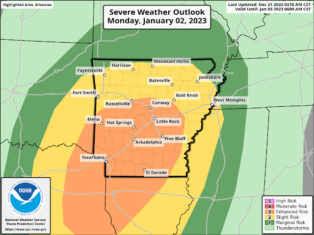
The greatest severe weather risk is to our southwest, although severe storms are possible in the metro as they move out of AR into north MS and west TN late Monday night. (NWS/SPC)

Rest of the week trends "normal"

A few lingering showers could last into Tuesday morning, but we should see a general drying trend Tuesday afternoon, even as the cold front associated with the overnight system finally moves through. Because most of the day will be in the warm sector, any breaks in the clouds could easily push the temperatures up to 70 degrees, which might spark a few showers along the front late in the day.

Beyond that, dry conditions and another cooldown is expected from mid-week to next weekend. Highs recede to the 40s to end the week as lows drop to near freezing, which is much more typical for this time of year. 

Looking ahead to 2023!

I'd like to close with a word of sincere appreciation for following MemphisWeather.net this past year and continuing to tell friends and family in the area about us! We're grateful that you include MWN as one of your trusted local weather sources and we look forward to a great year in 2023! 

Our plans for 2023 include a significant shift in our delivery of information online, particularly via mobile app, as well as more timely updates in a live format. Of course, we'll be continuing our tradition and calling to serve as a training ground for the next generation of talented young weather professionals, as they hone their skills in a practical, real-world environment. Our interns are the best and we're grateful for their service to us, and all of you! Special thanks to MWN veteran Caroline Sleeper who wraps up her second stint as a meteorology intern today and then finishes up her Master's Degree this spring! She is looking forward to "landing" a career in aviation meteorology, while gaining hours as a private pilot.

Blessings and good health in the New Year!


Erik Proseus
MWN Meteorologist

----
Follow MWN on Facebook and Twitter for routine updates and the latest info!
Complete MWN Forecast: MemphisWeather.net on the mobile web or via the MWN mobile app
Download our iPhone or Android apps, featuring StormWatch+ severe weather alerts!
MWN is a NOAA Weather Ready Nation Ambassador Meteorologist Erik Proseus is an NWA Digital Seal Holder

Tuesday, December 20, 2022

"Arctic Blast" - Video Forecast Discussion - December 20, 2022

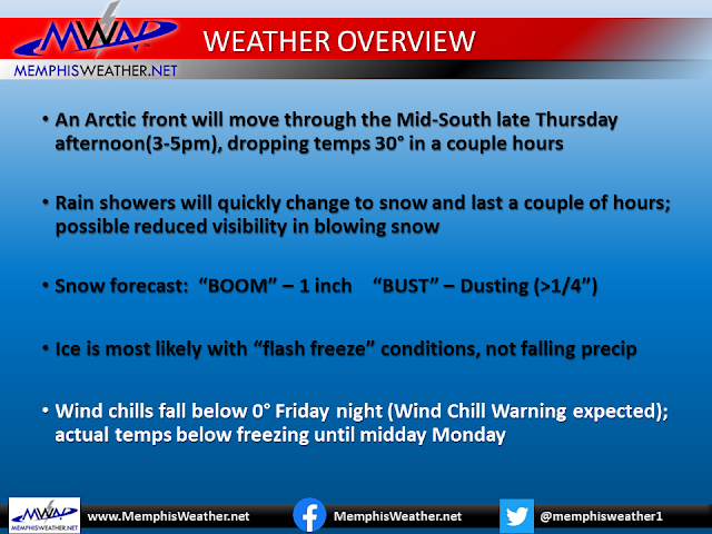
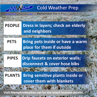
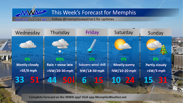
As the coldest December air in 33 years prepares to infiltrate the Mid-South just ahead of the busy holiday weekend, we review the atmospheric setup, the timing, the impacts, how to best prepare, and how long this cold spell will last! Below are a couple of the graphics used in the video to help summarize the event. 


Erik Proseus
MWN Meteorologist

----
Follow MWN on Facebook and Twitter for routine updates and the latest info!
Complete MWN Forecast: MemphisWeather.net on the mobile web or via the MWN mobile app
Download our iPhone or Android apps, featuring StormWatch+ severe weather alerts!
MWN is a NOAA Weather Ready Nation Ambassador Meteorologist Erik Proseus is an NWA Digital Seal Holder

Thursday, December 15, 2022

Winter arrives! Brace for cold air (...and winter shenanigans?)

First half of December wet and warm

We have dealt with almost two solid weeks of cloud cover, periods of fog, and multiple rainy systems and thunderstorms to start December. The result was 4-6" of rain, saturated ground, and a bunch of Mid-Southerners fighting Season Affective Disorder (making us feel SAD heading into the Christmas season)! Despite all this damp weather, the Drought Index valid this past Tuesday is a bit discouraging: 

The Drought Index valid December 13 indicates we still have a ways to go to get out from under our summer/fall drought, though areas south of I-40 in west TN could be out of the abnormally dry conditions as soon as next week. (UNL)

I expect we'll see improvement in next week's edition as it tends to lag actual conditions just a bit. But it is also proof that it takes prolonged wet weather to dig out from under a long-term drought! I suspect if you were to try and dig a hole in your yard, you would have some trouble once you get below the top 2-4"! That is drought -- not the standing water on top of the yard!

For the first two weeks of December, despite feeling cool and damp, the average temperature is actually 6.8° above normal! That is driven by both above average highs and lows, but low temperatures in particular have been quite warm for December thanks to all the cloud cover keeping us from dropping anywhere close to freezing since the 1st. That will change quickly now following yesterday's cold front. Readings near 60° are over for the month!

Second half of December brings the chill

A large dome of Arctic air has dropped across much of the eastern 2/3 of the nation, resulting in high temperatures locally in the 40s for the next week. We'll also get down to freezing nearly every morning for the next week. High pressure will control the weather for the majority of this time period resulting in mostly sunny skies. A cold front on Monday looked to potentially bring some precipitation, but it is starting to look like it may not be able to tap into enough moisture in the air to produce more than clouds, drying out as it approaches us Monday. If very light precip were to occur, it would likely be rain. 
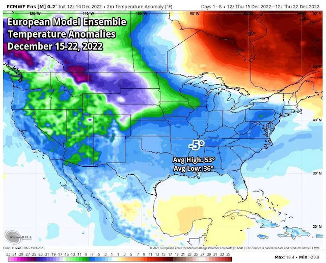
The European model ensembles from Wednesday morning (supported by other long-range model data) indicate a chilly airmass in the week behind yesterday's front with even colder air poised to dive southeast over the northern Plains. A 5° departure from normal would equate to highs in the 40s and lows near freezing, on average. (WeatherBell)

Behind that front, we'll have a couple more dry and cool days before a massive shot of polar air that will dive into the central U.S. will shove its way southeast into the Mid-South. While the next week will be chilly, the airmass arriving late next week promises to be #StupidCold, just in time for Christmas weekend. Early indications are that we may not rise above freezing for a few days over the Christmas holiday with wind chills probably into the single digits! As for precipitation....


Maybe?!

With all the usual caveats - it's a week out, it's the Mid-South, we have bluffs and I-40 (kidding!!) - the front will be potent enough that it could definitely generate precipitation, probably on Thursday the 22nd. 

Weather forecast map valid Thursday morning, Dec. 22. Polar air dropping through the central U.S. reaches the Mid-South with the potential for a quick shot of snow along the front. (NWS)

Factors that will have to be considered: timing (of the day) and near-surface temperatures, available moisture, system dynamics, etc. One negative factor to a potentially "good" snowfall is the speed of this system. The polar airmass will hit quickly and with a fury. Precipitation won't linger around as the very dry air behind the front quickly shuts precipitation off. Long-range models are not super helpful right now, but the ensembles of those models (which we use at longer ranges to detect trends, not details) are hinting at a quick shot of snow with the front. The MWN Forecast carries a chance of rain and snow on Thursday. We'll keep you posted as we get closer! What you should prepare for though is bitterly cold air for Christmas weekend!

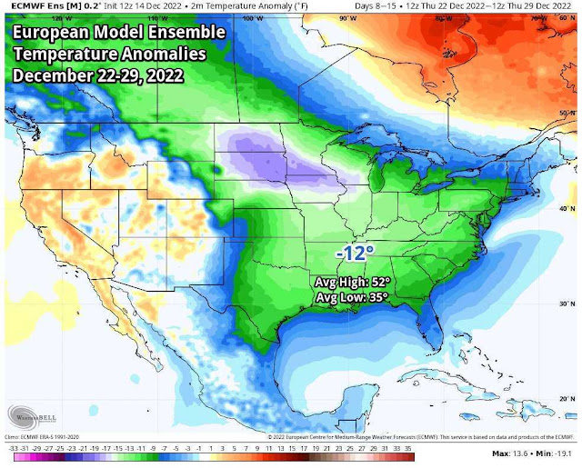
The same European model ensemble model temperature anomaly data shown above, only for December 22-29, showing that cold blast from the northern Plains encompasses much of the eastern U.S. A 12° departure from normal would mean highs averaging near 40° and lows in the low 20s. (WeatherBell)

Erik Proseus
MWN Meteorologist

----
Follow MWN on Facebook and Twitter for routine updates and the latest info!
Complete MWN Forecast: MemphisWeather.net on the mobile web or via the MWN mobile app
Download our iPhone or Android apps, featuring StormWatch+ severe weather alerts!
MWN is a NOAA Weather Ready Nation Ambassador Meteorologist Erik Proseus is an NWA Digital Seal Holder

Wednesday, December 14, 2022

Perspective on the 35th anniversary of the West Memphis tornado

[ This blog post was originally posted on the 25th anniversary of the West Memphis tornado of 1987. I am resurfacing it ten years later, on the 35th anniversary, for multiple reasons. 1) It was a significant and deadly event, which could have MUCH worse had the tornado hit the dog track packed with spectators. 2) And as the first in a triplicate of major weather events in a roughly two-week span, it also sparked the flame in me that continues to burn to this day, resulting in a career in aviation weather that has been fruitful and rewarding, as well as a side business that provides another outlet to exercise my passions for weather, making a difference by keeping people safe and informed, and giving back by mentoring the next generation of successful meteorologists. Thanks for reading! /EP ]

ORIGINALLY POSTED DECEMBER 14, 2012:

A quarter-century ago, I had been living in the Memphis area for just over a year and was in middle school when an event occurred that I now believe was the first spark that started the fire, igniting a passion that lives in me to this day and likely determined my future career path.

The West Memphis Tornado of 1987

On Monday, December 14, 1987, at 9:40pm, a major twister touched down just southwest of West Memphis, AR and moved rapidly northeast at 60 mph, tearing a path through the city across the Mississippi River from it's namesake, then blew across the Mighty Mississippi (thus disproving the myth that the river and bluffs protect Memphis and Shelby County) and into Meeman-Shelby Forest State Park in northwest Shelby County before lifting just west of Millington, TN.

Track of the F-3 tornado that passed through West Memphis, AR and crossed the river into Shelby County, TN

By the time it was done, F-3 damage was recorded in both Arkansas and Tennessee along a 25-mile path, six people were dead, and 121 others were injured.  Damage estimates were approximately $35 million [1987 dollars], including 235 homes, 35 businesses (many along Broadway street in downtown), and a school in West Memphis and 88 homes in the Northaven development west of Millington that were destroyed or heavily damaged.  In all, 1,500 people, or roughly 5% of the population of West Memphis, were left homeless.

According to Associated Press archives, Arkansas Governor Bill Clinton sent in the National Guard and additional state troopers to put a halt to looting in the central business district following the tornado.

The tornado also struck several high voltage power lines, including two 500,000 volt lines and three 161,000 volt lines, leaving much of Crittenden County, AR without electric power. Those killed included a woman in her mobile home, an elderly man in a boarding house, a teenager in a grocery store parking lot, a one-year-old child in an apartment building, a person in a vehicle that was thrown on I-40, and a person in a truck stop parking lot.

As bad as it was, the destruction could have been much worse.  At the time of the tornado, 7000 spectators were at Southland Greyhound Park dog-racing track in West Memphis, which the twister missed by just one-quarter mile. Video below is courtesy KATV meteorologist Todd Yakoubian (@KATV_Weather on Twitter).


Meteorological setup

From a meteorological perspective, the tornado appeared to form just behind a warm front that lifted through the area.  From observations taken at Memphis International Airport (the closest recording station to the tornado), it was 50 degrees at 7pm with wind from the east at 6 mph and dense fog being reported. An hour later, the temperature had climbed to 66 degrees (after dark) and wind shifted to the southeast at 21 mph with fog lifting. Between 9:00-10:15pm, the temperature was 70 degrees and wind gusted from the southwest at up to 40 mph as pressure bottomed out at 29.38".

Surface map valid at 9pm with the surface low moving by just west of West Memphis.  The map indicates that it was 70 at Memphis Int'l and 40 in Jonesboro, AR with heavy snow falling in the Ozarks.

By 7am the next morning, the temperature had fallen back to 32 degrees following a night of westerly wind that gusted between 35-48 mph.  Weather maps show a potent upper-level disturbance moving by just west of the area and a rapidly-strengthening surface low moving through AR that evening.

Daily weather map for the morning of December 14, 1987. Low pressure over south TX lifted rapidly north and strengthened, reaching Chicago the next morning. The track of  the low through AR put the Mid-South in prime position for wintertime severe weather.

Upper level weather maps from December 14, 1987 at 6pm. Upper left: a strong jet stream over the Mid-South. Upper-right: an upper-level disturbance moving by to the west. Lower-left: low pressure at 5,000' over southern MO. Lower-right: surface low pressure over AR moving rapidly north, placing the Mid-South in the storm's "warm sector."

A triple case of bad luck

Unfortunately, the tornado was just the first event in a series of cases of bad luck dealt by Mother Nature. The town had not recovered from the tornado when parts of it flooded from 12" of rain eleven days later, on Christmas Eve night, leaving 1000 homes flooded and another person dead. Then, 7-10" of snow fell on January 6, another 11 days after the flooding rains. As snow melted, it added to the already existing misery caused by the flood and the destruction caused by the tornado.  Oddly enough,  West Memphis became the first U.S. city to be declared a federal disaster area twice in a two-week period due to this string of events.

A personal note

Many times, when a meteorologist is asked what triggered their interest in weather, it is a singular event that had an impact on their life. For many years, I was unsure of what that event in my life was.  However, I knew that my passion began in the middle school years, shortly after I relocated with my family to the Memphis area. There is no doubt now though, as I now vividly recall the destruction of the city upon driving through it with my parents within a few days of the tornado, that the West Memphis tornado of 1987 was THAT event in my life. I find it hard to believe that it was 25 years ago!  Perhaps that is also why I am so passionate about making sure people are informed and taking precautions when severe weather strikes, which has resulted in the services offered by MemphisWeather.net and our mobile app-based weather alert system - StormWatch+.

Do you have more than a passing interest in weather, even if you're not in the profession?  What event triggered your  interest?  If you've lived in the Mid-South for a quarter century, what do you recall about this event? I'd love to see your comments below!

Erik Proseus
MWN Meteorologist

--- 
Follow MWN on Facebook and Twitter for routine updates and the latest info! 
Complete MWN Forecast: MemphisWeather.net on the mobile web or via the MWN mobile app 
Download our iPhone or Android apps, featuring StormWatch+ severe weather alerts!
MWN is a NOAA Weather Ready Nation Ambassador Meteorologist Erik Proseus is an NWA Digital Seal Holder


Saturday, December 10, 2022

November 2022 Climate Report for Memphis, TN

November Climate Recap

Temperatures for the month of November in Memphis averaged just below normal, though about two-thirds of the month was actually above normal. The average was skewed down by a 10-day cold snap mid-month with multiple days 10-16 degrees below average, several of them sporting highs only in the 40s. That also drove up the number of sub-freezing mornings we experienced, with 11 days at or below 32 versus an average for November of about four. 

The temperature anomaly map for the month of November shows slightly below average temperatures across the Mid-South. (PRISM temperature data via WeatherModels)

With slightly below average precipitation recorded, minor drought conditions continued through the month, and actually worsened slightly for Tipton and Fayette Counties (from abnormally dry to moderate drought). East AR remains in severe drought as we head into December. The wettest day of the month was on the 5th when thunderstorms moved through the area. The cold spell mid-month was primarily dry, before multiple wet days occurred in the last week of the month, though not with excessive rainfall. A little over an inch fell with additional storms on the 29th. These storms also brought hail to southern Shelby County and sporadic wind reports south and east of Collierville. Severe Thunderstorm Warnings were issued.

Memphis International Airport, Memphis, TN

Temperature 
Average temperature: 52.1 degrees (0.6 degrees below average) 
Average high temperature: 61.9 degrees (0.7 degrees below average) 
Average low temperature: 42.3 degrees (0.6 degrees below average) 
Warmest temperature: 82 degrees (8th) 
Coolest temperature: 24 degrees (21st) 
Heating Degrees Days: 398 (19 above average)
Cooling Degree Days: 20 (8 above  average) 
Records set or tied: None
Comments: Eleven days dropped to 32 degrees or below this month, which is 6.7 days above the average November. 

Precipitation 
Monthly total: 3.62" (1.07" below average) 
Days with measurable precipitation: 9 (0.0 days below average) 
Wettest 24-hour period: 1.61" (5th) 
Snowfall: 0.0"
Records set or tied: Daily maximum rainfall set on the 5th (1.61")
Comments: None 

Miscellaneous 
Peak wind: South-southeast/45 mph (4th) 
Average wind: 6.7 mph 
Average relative humidity: 69%
Average sky cover: 49%

 Click here for a daily statistical recap for Memphis International Airport.
 

Cirrus Weather Solutions / MemphisWeather.net, Bartlett, TN

Temperature 
Average temperature: 50.0 degrees 
Average high temperature: 62.2 degrees 
Average low temperature: 39.6 degrees 
Warmest temperature: 81.1 degrees (9th) 
Coolest temperature: 19.8 degrees (21st) 
Comments: None 

Precipitation 
Monthly total: 3.40" (automated rain gauge), 3.35" (manual CoCoRaHS rain gauge) 
Days with measurable precipitation: 9
Wettest date: 1.89" (5th) (via automated gauge) 
Snowfall: 0.0"
Comments: None

Miscellaneous 
Peak wind: Southeast/32 mph (29th)
Average relative humidity: 73% 
Average barometric pressure: 30.17 in. Hg
Comments: None

Click here for a daily statistical recap for Bartlett, TN.
 

MWN Forecast Accuracy

MWN average temperature error: 2.08 degrees 
MWN forecast temperatures within 2 degrees of actual: 69% 
MWN average dewpoint error: 2.25 degrees 
MWN forecast dewpoints within 2 degrees of actual: 65% 

MWN's forecasts extend out five periods (2.5 days, or roughly 60 hours). Historical accuracy statistics can be found here.

--- 
Follow MWN on Facebook and Twitter for routine updates and the latest info! 
Complete MWN Forecast: MemphisWeather.net on the mobile web or via the MWN mobile app 
Download our iPhone or Android apps, featuring StormWatch+ severe weather alerts!
MWN is a NOAA Weather Ready Nation Ambassador Meteorologist Erik Proseus is an NWA Digital Seal Holder


Sunday, November 27, 2022

Early details on the severe weather threat for Tuesday (Nov. 29)

The Thanksgiving holiday has been somewhat dreary and damp, and definitely cloudy, thanks to a slowly-lumbering upper level low that passed nearby. As that 800-lb gorilla moseys away, a much more dynamic atmospheric setup will move through the Mississippi Valley early this week - one that poses a level of severe weather risk that we have not seen in some time. These late-season severe patterns can be tricky, but also quite potent when they do come into form. (Some may remember or have heard of the Thanksgiving weekend Germantown EF-3 tornado that occurred nearly 30 years ago. Tornadoes in the cool season are definitely possible in the Mid-South.) This one will definitely bear watching, and require your attention and preparation.

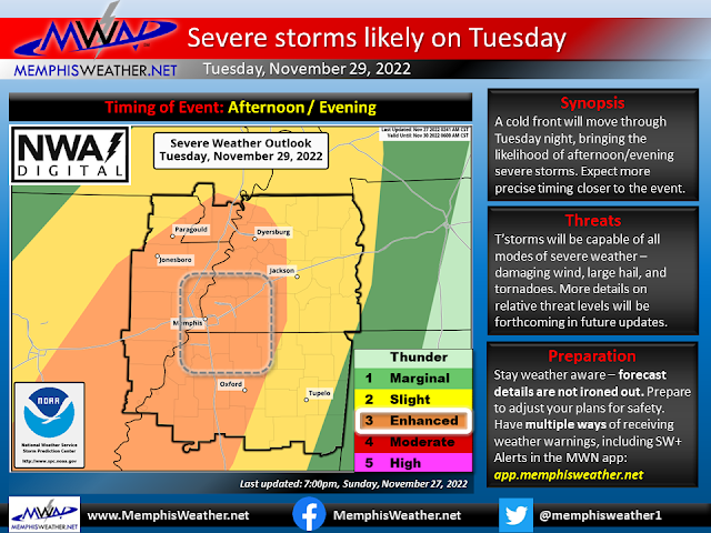
Tuesday is the day of concern. While this event is still 48+ hours out, some atmospheric parameters are coming into place and others are still unknown, and as usual there are also a few potential flies in the ointment. Currently, the Memphis metro is in an "Enhanced Risk" of severe weather, or level 3 out of 5, according to the severe weather experts at the National Weather Service. Let's run through the scenario.

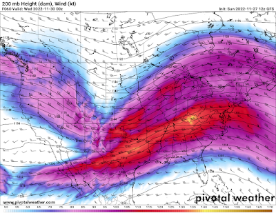
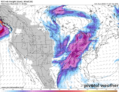
What we know: an upper level jet stream blowing at over 150 mph will be screaming overhead from the west-southwest, ahead of a strong upper level trough (lower pressures) moving east across the Plains. Also, very strong wind at the low and mid levels also appears to be a given (50+ mph at about 2000 feet and gusts to 30 mph at the surface, blowing from the south). That means that we have one key ingredient: wind shear.  There also will be a lifting mechanism to get air rising - producing the convective process to initiate thunderstorms: an approaching cold front, and perhaps a pre-frontal surface trough. In addition, moisture will be abundant is well-above-average surface dewpoints in the lower, to possibly mid, 60s are expected. 

The jet stream will be strong (150 mph wind), and basically directly overhead, by 6pm Tuesday.  (GFS model, Sunday 12Z)

A low level jet stream will also be quite strong and overhead early Tuesday evening, topping out above 50 mph. (GFS model, 12Z Sunday)

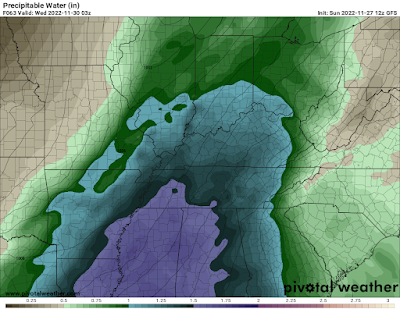
Atmospheric moisture, as measured by precipitable water (PW) at 9pm Tuesday is forecast to be well above average, or nearly 1.5" (GFS model, 12Z Sunday)

What is not quite as certain: the amount of "storm food," or fuel, that is needed to keep air rising once it is lifted, and thus tap into the abundance wind shear.  In the cool season, it doesn't take nearly as much instability to generate severe weather as it is often compensated for by an abundance of wind shear, which will be the case this time. It does take SOME instability though, and how much we will have is a big question mark. Models are all over the place, and tend to under-forecast this parameter a few days out. I'm betting we'll have enough to generate strong storms, and if they can become strong, they will certainly have the potential to be severe.

Instability, or storm fuel, as measured by CAPE is one of the big question marks, though we should have sufficient fuel for storms. This Euro model representation at 9pm Tuesday is one of the higher solutions we have seen, with values near 1000. Other models only show a couple hundred CAPE. (WeatherBell)

How it might play out: I expect that we'll see some daytime "elevated" thunderstorms, mainly in the afternoon hours, as an initial push of moisture and mid-level instability arrives on gusty south wind, as dewpoints climb into the 60s. These could have the potential to produce some gusty wind and large hail, as well as localized downpours. 

By late afternoon, and more likely during the evening, the more potent atmosphere appears to move in as surface-based instability rises (again, we don't know how much). While it is possible that there will be fewer echoes on radar after sunset than during the afternoon, the potential for them to be strong to severe will be heightened. Rotating storms are entirely possible, and thus we have a potential for large hail, damaging wind gusts, and even a few tornadoes, which could be strong. Late in the night, the cold front itself arrives, so the storm threat continues overnight. It's a bit more uncertain how those could behave. We may have to wait and see how the day unfolds to know for sure.


Bottom line: all Mid-Southerners need to be preparing now for the potential for severe storms, capable of large hail, damaging wind, and tornadoes, from Tuesday afternoon into Tuesday night. Secure items outdoors that you want to keep, plan to garage vehicles as able on Tuesday, and stay tuned to additional details that will help you plan your activities for the day. As of right now, Tuesday evening is my greatest concern. If you have flexible plans, go ahead and adjust now. By all means, STAY IN TOUCH with your trusted weather sources as details are likely to change in the next 48 hours, and have multiple methods of receiving severe weather alerts prepared in case they are needed Tuesday.


Erik Proseus
MWN Meteorologist

----
Follow MWN on Facebook and Twitter for routine updates and the latest info!
Complete MWN Forecast: MemphisWeather.net on the mobile web or via the MWN mobile app
Download our iPhone or Android apps, featuring StormWatch+ severe weather alerts!
MWN is a NOAA Weather Ready Nation Ambassador Meteorologist Erik Proseus is an NWA Digital Seal Holder

Tuesday, November 22, 2022

Consider the forecast before making those Thanksgiving holiday plans!

After two weeks of cold weather, a little bit of a warmup is in store for the southeast this week! The past couple of days have shown this cold trend. Temperatures on Saturday only reached the low 40s with lows in the upper 20s. Sunshine was abundant on Sunday as temperatures were once again in the low 40s with an even colder night than Saturday. Yesterday was the first day of our warmup with temperatures climbing into the low 50s as a warm front is beginning to make its way through. Despite the chilly weather, skies have been mostly clear the past few days as a high pressure was over our region. This week, a low-pressure system is going to be moving into the area from the southern plains which will bring some warmer temperatures but also a good bit of rain Thursday and into Friday.

Tuesday Night into Wednesday

Today temperatures are continuing to be on the rise with highs near 60 degrees with mostly sunny skies. While this is average for this time of the year, it is going to be great relief from the chilly weather we have been experiencing. Tuesday night will be chilly with temperatures in the upper 30s, but temperatures will warm up to the low to mid 60s for the day Wednesday thanks to the warm front and high pressure that is continuing to push through the area. Skies are going to be partly sunny with clouds increasing through the day but no rain is expected. Wednesday is looking to be a beautiful day for anyone traveling for Thanksgiving!

Thanksgiving and Black Friday

Surface weather map for Thursday morning showing the rain for the area caused by the low-pressure system over Oklahoma. (Weather Prediction Center) 

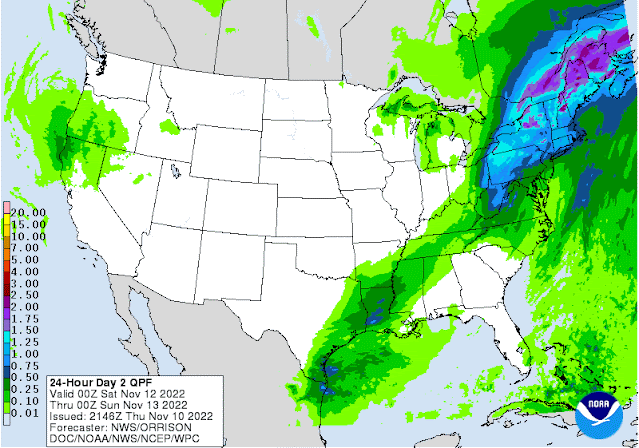
As the high pressure moves out of the area, a low-pressure system will begin to take its place, which is going to make for a soggy Turkey Day. Rain showers are looking to begin early Thursday morning and will continue to be scattered throughout the area through late morning. Widespread rain will be moving in from the southwest during the afternoon due to the low-pressure system and cold front that is going to park itself over Oklahoma and Texas. Despite this, temperatures will rise to the low 60s. With winds from the east/southeast, plenty of moisture will be available for this system to use from the Gulf. We could see anywhere from one-half to over two inches of rainfall in the region through midnight Thursday with amounts being greater to the south.

Total rainfall forecasted through Friday at noon. (Weather Prediction Center) 

On Friday, we see a large upper-level trough continuing to move east into the southeast region of the country. Thursday’s rainfall will decrease and end into the Friday morning hours, leaving mostly cloudy skies for Black Friday shopping. Temperatures will be a bit cooler, in the mid-50s, after the Thanksgiving rain, but still warmer than last week! Going into the nighttime hours, temperatures will drop into the mid-40s so a jacket will be needed for any evening shopping or playoff football! We will likely see rain showers from the low-pressure system to the south, especially as we head later into Friday night.

500mb (18,000') pressure and wind pattern from the GFS model showing the large upper level low pressure system, which will be responsible for our Friday and Saturday rain chances, centered over Oklahoma/Texas on Friday. (Pivotal Weather)

Saturday and Sunday

Scattered showers will continue into Saturday morning. By Saturday night the low pressure system will have moved north/northeast and the rain will have moved out of the area. High temperatures will rise to the mid-50s and the low will be in the lower 40s. Going into Sunday, a high-pressure system trailing behind the low pressure that just moved out is going to fill into the area. This ridge is going to dry us out once again for the end of the weekend and into early next week. Temperatures will warm up to around 60 and the low will drop to the mid-40s. After a wet holiday week and beginning of the weekend, Sunday is going to be pleasant and dry with partly cloudy skies.

As low-pressure moves out of the area late Saturday, high pressure will move into the area Sunday, as shown by the GFS model. (Pivotal Weather)
Kailah Gordon
MWN Intern

----
Follow MWN on Facebook and Twitter for routine updates and the latest info!
Complete MWN Forecast: MemphisWeather.net on the mobile web or via the MWN mobile app
Download our iPhone or Android apps, featuring StormWatch+ severe weather alerts!
MWN is a NOAA Weather Ready Nation Ambassador Meteorologist Erik Proseus is an NWA Digital Seal Holder

Thursday, November 10, 2022

Big changes coming: Temperatures tumble, plus the tropics aren’t done

If you’ve found yourself wishing away the unseasonably warm temperatures we’ve had this fall, you’re going to enjoy the changes headed our way! We have a pretty active weekend ahead of us.

First: The Tropics

Nicole made landfall just south of Vero Beach, Florida early Thursday morning as a category one hurricane with estimated wind speeds of 75 miles per hour. The current National Hurricane Center Track takes Nicole through central Georgia on Friday and to the northeast towards New England by Saturday. While most of the tropical system’s impacts will remain well to our east, north MS and west TN might see some clouds filter in and winds pick up a bit on Friday as the low makes its northern turn through Georgia.

Nicole stays well to our east as it moves up the east coast and a strong cold front approaches from the plains. (Pivotal Weather)


Big temperature swing coming...

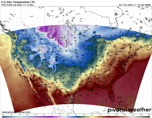
More rural areas have already seen sub-freezing temperatures, but this weekend will likely bring our first sub-freezing temperatures in the city itself. Our main story starting Friday is a strong cold front brought about by an upper-level trough swinging through the eastern U.S. As of lunchtime on Thursday, the cold front was draped from Wisconsin down through Oklahoma and continues to push eastward.  The front will be approaching the metro Friday evening, ushering in borderline-winter-like temperatures, and the cold is here to stay this time. A strong northerly wind will pick up in the wake of the front, and temperatures will drop to the mid-30s Friday night with showers likely, but probably not until after high school football playoff games end for the evening! Precipitation from the front itself will dissipate as it approaches the metro, but a weak upper level disturbance following just after will bring rainfall in from the southwest.

Nicole stays well to our east as it moves up the east coast and a strong cold front approaches from the plains. (Pivotal Weather)

Here’s a still shot from the HRRR of surface temperatures at 6pm on Friday as the front approaches the metro. (Pivotal Weather)


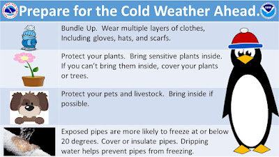
Now, I tread carefully with this one, but areas northwest of us in NE Arkansas have the potential to see some sleet/wintry mix in the pre-dawn hours Saturday morning as cold air rushes in. Rest assured, surface temperatures will still be above freezing so there will be little to no impact. I’m not expecting too much in the way of precipitation amounts - maybe a tenth to a quarter of an inch with slightly higher amounts well to the south of the metro. Saturday night, lows to drop to around 30, so remember to cover your plants and bring your four-legged friends inside. Don’t be caught without a coat this weekend as temperatures won’t make it out of the 40s during the daytime despite sunshine. Thankfully these overnight temperatures aren’t quite cold enough to warrant more extreme precautionary measures, such as dripping faucets or covering outdoor pipes.


Early next week

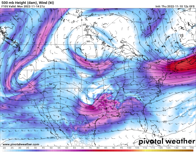
Temperatures start to creep back up into the 50s on Monday, which is actually when our next chance for rain presents itself. A strong upper level trough pushes its way across the U.S. early next week, bringing about a storm system across the southern Plains into the Mid-South. Our chances for rain extend from Monday night into early Tuesday morning. Right now I’m looking for somewhere between a quarter and a half of an inch of precipitation with areas south of Memphis (again) receiving higher amounts. Rain gives way to a drier pattern in the middle of the week, but cooler temperatures stick around with highs in the upper 40s/low 50s through the end of the week.

The upper level disturbance responsible for our rain chances on Monday night can be seen over northern TX on this forecast map of the atmosphere at about 18,000 feet up. (Pivotal Weather)

Caroline Sleeper
MWN Meteorologist

----
Follow MWN on Facebook and Twitter for routine updates and the latest info!
Complete MWN Forecast: MemphisWeather.net on the mobile web or via the MWN mobile app
Download our iPhone or Android apps, featuring StormWatch+ severe weather alerts!
MWN is a NOAA Weather Ready Nation Ambassador Meteorologist Erik Proseus is an NWA Digital Seal Holder

Monday, November 7, 2022

October 2022 Climate Report for Memphis, TN

October Climate Recap

Temperatures for the month of October in Memphis averaged just below normal, though the number of above and below average days were fairly equal. Most of the above average days were in the last third of the month, while a cold spell mid-month (highs in the 50s) helped to skew the monthly average down. Despite the swings in temperatures, there were no days that reached 90 degrees.

The temperature anomaly map for the month of October shows slightly below average temperatures across the Mid-South. (PRISM temperature data via WeatherModels)

Drought conditions continued early in the month with no precipitation until mid-month, when a couple of wet systems moved through dropping a couple of inches of rain as well as producing thunderstorms. After another dry spell, rainfall returned again in the past week of the month, including the wettest day in over 18 months at the airport on the 29th with 2.37" of rain. The thunderstorms on the 12th resulted in a couple of reports of hail in northwest MS. Severe Thunderstorm Warnings were issued on the 15th for storms moving through Tipton County though there were no reports of severe weather. 

Memphis International Airport, Memphis, TN

Temperature 
Average temperature: 63.2 degrees (1.4 degrees below average) 
Average high temperature: 74.5 degrees (0.6 degrees below average) 
Average low temperature: 51.9 degrees (2.1 degrees below average) 
Warmest temperature: 85 degrees (6th, 12th) 
Coolest temperature: 35 degrees (19th) 
Heating Degrees Days: 102 (14 below average)
Cooling Degree Days: 54 (48 below  average) 
Records set or tied: None
Comments: No days reached 90 degrees this month, which is 0.9 below the average October. 

Precipitation 
Monthly total: 4.82" (0.84" above average) 
Days with measurable precipitation: 6 (1.5 days below average) 
Wettest 24-hour period: 2.37" (29th) 
Snowfall: 0.0"
Records set or tiedDaily maximum rainfall set on the 29th (2.37")
Comments: None 

Miscellaneous 
Peak wind: Northwest/46 mph (12th) 
Average wind: 7.9 mph 
Average relative humidity: 58%
Average sky cover: 31%

 Click here for a daily statistical recap for Memphis International Airport.
 

Cirrus Weather Solutions / MemphisWeather.net, Bartlett, TN

Temperature 
Average temperature: 60.6 degrees 
Average high temperature: 75.0 degrees 
Average low temperature: 48.4 degrees 
Warmest temperature: 87.9  degrees (12th) 
Coolest temperature: 29.3 degrees (19th) 
Comments: None 

Precipitation 
Monthly total: 2.77" (automated rain gauge), 2.90" (manual CoCoRaHS rain gauge) 
Days with measurable precipitation: 5
Wettest date: 1.60" (29th) (via automated gauge) 
Snowfall: 0.0"
Comments: None

Miscellaneous 
Peak wind: Southeast/29 mph (29th)
Average relative humidity: 66% 
Average barometric pressure: 30.07 in. Hg
Comments: None

Click here for a daily statistical recap for Bartlett, TN.
 

MWN Forecast Accuracy

MWN average temperature error: 1.78 degrees 
MWN forecast temperatures within 2 degrees of actual: 78% 
MWN average dewpoint error: 1.98 degrees 
MWN forecast dewpoints within 2 degrees of actual: 81% 

MWN's forecasts extend out five periods (2.5 days, or roughly 60 hours). Historical accuracy statistics can be found here.

--- 
Follow MWN on Facebook and Twitter for routine updates and the latest info! 
Complete MWN Forecast: MemphisWeather.net on the mobile web or via the MWN mobile app 
Download our iPhone or Android apps, featuring StormWatch+ severe weather alerts!
MWN is a NOAA Weather Ready Nation Ambassador Meteorologist Erik Proseus is an NWA Digital Seal Holder