Thursday, December 21, 2023

Not a White Christmas, but a Wet Christmas

As fall officially turns to winter, temperatures are (of course!) warming as we head into a long Christmas weekend. I think we'll take that if the other option is what we had last year - frozen pipes and rolling blackouts! The trade-off is going to be rainy conditions off and on through the weekend. Let's talk about it.

Temperature in Bartlett just before 6am on December 23, 2022 (-0.3°)

As high pressure that brought us cold weather earlier this week slides to our east, wind has shifted to the south, resulting in warmer air over the Mid-South. Low pressure will develop to the west and moisture will increase from the Gulf of Mexico. That will mean less itchy, dry skin as dewpoints have risen from the teens a couple of days ago into the 30s by Friday, and eventually the 40s to 50s later this weekend. 


With the increase in moisture, small rain chances in the form of hit-and-miss brief showers will pop up late Friday and into the weekend. Outdoor plans through much of the weekend, until Sunday evening, should not be overly impacted, and the mild temperatures will make for pleasant conditions for outdoor activities outside of breezy south wind. Just keep in mind that a shower could pop up about anytime 

A loop of the surface weather maps from Friday morning through Tuesday morning, showing 

The main event from the next system will occur on Sunday evening though Monday morning - Christmas Eve into Christmas Day. Heavy rain is likely at times overnight Sunday night and a few rumbles of thunder are even possible. (It may not be reindeer hooves on the roof you hear that night!) Severe thunderstorms are not expected as the primary low pressure center passes well to our north and instability will be limited. Some showers appear to linger into Christmas Day, but could be departing by the afternoon hours. Still too early to know... stay tuned to the MWN Forecast for updates throughout the next few days. The rest of the intra-holiday week looks to be dry and cooler again.

And for those asking about winter weather in early January, it's ENTIRELY too early to even discuss...


Erik Proseus
MWN Meteorologist

----
Follow MWN on Facebook and Twitter for routine updates and the latest info!
Complete MWN Forecast: MemphisWeather.net on the mobile web or via the MWN mobile app
Download our iPhone or Android apps, featuring StormWatch+ severe weather alerts!
MWN is a NOAA Weather Ready Nation Ambassador Meteorologist Erik Proseus is an NWA Digital Seal Holder

Thursday, December 7, 2023

Digging into the potential for a holiday-season storm event on Saturday

As we approach another busy holiday season weekend, the threat of rain and thunderstorms is threatening to put a damper on at least half of it. The fact that there is some potential for strong to severe storms reminds us that it is not just the holiday season, but also still secondary severe weather season in Dixie Alley. Let's take a look at what to expect for those with Saturday shopping, decorating, baking, or other "tis the season" plans.

Priming the atmospheric pump

A December warm-up has commenced. High temperatures were back into the lower 60s Thursday afternoon and slightly warmer conditions are on tap Friday, despite more cloud cover, as southerly flow has become established across the region. That will also lead to milder overnight conditions heading towards the weekend, as well as rising dewpoints - a sign that moisture is increasing. 

Friday will be "pump primer day" as dewpoints steadily climb into the 50s on gusty south wind, heading towards 60 degrees by Saturday morning. Cloud cover will also thicken up Friday as upper level moisture also increases. A few sprinkles or a brief afternoon shower are possible, though most stay dry before sunset. By Friday evening, conditions will be very mild with after-dusk temperatures near 60 and southerly wind gusts to 25 mph. The chance of showers climbs in the evening as well, so though it will be comfortable, raindrops will be scattered around if you are going to holiday parties/events or the Grizzlies matchup with the Timberwolves downtown.

Forecast dewpoints from Friday sunrise through midnight. Southerly flow will bring increasing moisture to the region on Friday. (WeatherBell)

Saturday: a wash-out at a minimum

By Saturday morning, the cold front that will likely disrupt outdoor events during the day will have made its across AR a chunk of Arkansas. Where exactly it will be is still TBD, but it is safe to say it will be to our west, which puts areas from Louisiana and southern AR into the Mississippi Delta, and potentially the Memphis metro, in a zone of unsettled conditions. As low pressure moves along the front, it will bring more unstable air into this "zone of unsettled-ness," juxtaposed with increasing wind aloft that could serve to strengthen any storms that can form in warm, unstable air. We do expect to see thunderstorms embedded within areas of heavy rain during the day Saturday, but the degree to which they become "strong" or even severe, is a tricky question, even if you were to forget that it is indeed December. 

Surface weather map on Saturday at 6am (NWS/WPC)

What is unknown as of Thursday evening is how much storm fuel (aka, instability) will be present over our area and when exactly the front will move through, which will bring an abrupt end to the severe weather chances. While the wind energy over the Mid-South seems sufficient to support a low-end severe weather threat, instability is likely to be more prolific to our south. The later the front arrives (i.e., late afternoon), the better the chances are that we see scattered strong to severe wind gusts. If it seeps southeast into the metro earlier in the day, it will shove the unstable air to our east and we'll be in for a wet, but not too stormy, day. 


Most computer model solutions right now favor a mid-afternoon frontal passage. Thus, the Storm Prediction Center currently has their level 2 ("Slight") severe weather risk area extending over the metro (see above). Should we get strong storms, they would be most likely in the afternoon hours and damaging wind would be the greatest concern, besides heavy rain. Tornado and hail threats appear fairly low. In any case, rain looks to continue through the evening hours and could be heavy at times, as temperatures begin their plummet from the upper 60s towards the upper 30s by Sunday morning. It won't be a pleasant evening by any stretch.

Cold winter air arrives

Behind the front, cool high pressure quickly builds in. In fact, it will be downright cold on Sunday, despite abundant sunshine. Wind chills in the morning will be in the 20s and high temperatures in the afternoon only in the mid 40s! A great day to sip a warm beverage indoors and gaze outside at the seemingly beautiful day. The rest of next week is dominated by cool high pressure. Rain chances don't reappear until the following weekend, natch, with highs generally in the mid 50s and lows in the 30s. 

Erik Proseus
MWN Meteorologist

----
Follow MWN on Facebook and Twitter for routine updates and the latest info!
Complete MWN Forecast: MemphisWeather.net on the mobile web or via the MWN mobile app
Download our iPhone or Android apps, featuring StormWatch+ severe weather alerts!
MWN is a NOAA Weather Ready Nation Ambassador Meteorologist Erik Proseus is an NWA Digital Seal Holder

Tuesday, December 5, 2023

November 2023 Climate Report for Memphis, TN

November Climate Recap

The month of November was generally warm and averaged more than a two degrees above normal. The start of the month was below freezing the morning of the 1st, with temps only making it to the low 50's during the afternoon. Temperatures warmed to the low 70's by the 4th, and into the low 80's on the 6th through 8th, but fell to the 60's by the 10th. High temperatures generally remained in the 60's to near 70 degrees through mid-month, dropping back to the 50's by the 21st. On Thanksgiving, we were near 60 degrees, with highs back in the upper 40's to near 50 to finish out the month.

Departure from normal temperatures for November for the Lower 48 states

Below normal precipitation trends continued in November. The ongoing drought improved somewhat in Tennessee, but much of north Mississippi continues to experience severe to extreme drought, with exceptional drought further south.  The image below highlights the drought conditions as of November 28th, and the second one shows the improvement (green) or worsening (yellow) drought conditions. There was no severe weather during the month, although thunderstorms with heavy rain affected the metro on the 20th.
Current drought conditions as of November 28th, 2023

Change in drought conditions from October 31st to November 28th

Memphis International Airport, Memphis, TN

Temperature 
Average temperature: 55.0 degrees (2.3 degrees above average) 
Average high temperature: 65.4 degrees (2.8 degrees above average) 
Average low temperature: 44.6 degrees (1.7 degrees above average) 
Warmest temperature: 84 degrees (8th) 
Coolest temperature: 29 degrees (27th) 
Heating Degrees Days: 313 (66 below average)
Cooling Degree Days: 22 (10 above average) 
Records set or tied: Record highs on the 6th (81) and 8th (84); record high tied on the 7th (83)
Comments: None

Precipitation 
Monthly total: 3.02" (1.67" below average) 
Days with measurable precipitation: 6 (3.0 days below average) 
Wettest 24-hour period: 1.54" (20th) 
Snowfall: None
Records set or tied: None
Comments: None

Miscellaneous 
Peak wind: Southwest/40 mph (8th) 
Average wind: 6.3 mph 
Average relative humidity: 62%
Average sky cover: 47%

 Click here for a daily statistical recap for Memphis International Airport.
 

MemphisWeather.net Headquarters, Bartlett, TN

Temperature 
Average temperature: 51.5 degrees 
Average high temperature: 64.0 degrees 
Average low temperature: 40.7 degrees 
Warmest temperature: 82.6 degrees (8th) 
Coolest temperature: 26.6 degrees (27th) 
Comments: The high of 80.4 degrees on the 6th broke the previous record high of 78.1 for that day in 2005.

Precipitation 
Monthly total: 2.51" (automated rain gauge), 2.62" (CoCoRaHS rain gauge) 
Days with measurable precipitation: 4
Wettest date: 1.41" (20th) (via automated gauge) 
Snowfall: None
Comments: None

Miscellaneous 
Peak wind: South/26 mph (8th)
Average relative humidity: 72% 
Average barometric pressure: 30.15 in.
Comments: None

Click here for a daily statistical recap for Bartlett, TN.
 

MWN Forecast Accuracy

MWN average temperature error: 2.15 degrees 
MWN forecast temperatures within 2 degrees of actual: 59% 
MWN average dewpoint error: 2.39 degrees 
MWN forecast dewpoints within 2 degrees of actual: 69% 

MWN's forecasts extend out five periods (2.5 days, or roughly 60 hours). Historical accuracy statistics can be found here.

----
Follow MWN on Facebook and Twitter for routine updates and the latest info!
Complete MWN Forecast: MemphisWeather.net on the mobile web or via the MWN mobile app
Download our iPhone or Android apps, featuring StormWatch+ severe weather alerts!
MWN is a NOAA Weather Ready Nation Ambassador Meteorologist Erik Proseus is an NWA Digital Seal Holder

Wednesday, November 29, 2023

Rainy and breezy as the calendar flips, but what about the weekend?

A generally cool and dry pattern changes for a few days as we head to the end of November and into the last month of 2023. A storm system exiting the Rockies and heading across the southern Plains and into the Deep South will bring us rainfall and perhaps a few thunderstorms in the next 36 hours. It could also affect your outdoor Christmas decor! But it is also a weekend chock full of seasonal activities, so what about rain chances and temperatures for the weekend? Let's dive in!

Thursday/Thursday night

A bit milder weather is expected tonight with southerly wind and high clouds moving in as temperatures only reach the 30s in rural areas. The rest of us will see lows at or above 40 tonight. Clouds thicken tomorrow as low pressure moves through the southern Plains and rain spreads towards the Mid-South, arriving around mid-afternoon as temperatures peak near 60. Rain picks up heading into the evening with a few rumbles of thunder possible as well. 

Forecast precipitation via the NWS National Blend of Models shows totals should generally run above a half inch, but less than an inch in the metro. (WeatherBell)

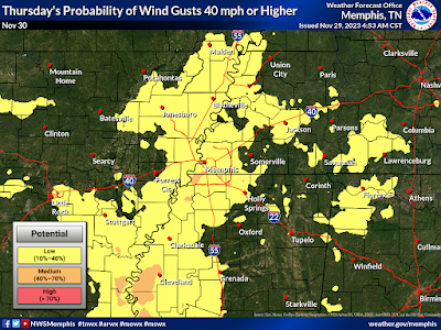
Southerly wind also increases Thursday night with frequent gusts to 30 mph and a few possibly approaching 40 mph! A Wind Advisory has been issued so make sure the outdoor decor is tied down well, or maybe just moved inside if possible for those inflatables! Temperatures remain mild overnight - in the 50s - as rain falls much of the night. 

Probability of wind gusts exceeding 40 mph on Thursday (night). Frequent gusts above 30 mph are likely. (NWS-Memphis)

Friday/Saturday

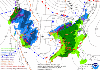
Most rain will be gone by Friday morning, but with the front still to our west as it's parent low pressure center moves into the mid-Mississippi Valley, it will remain mild with a breezy southwest wind. High temperatures should be well above average despite persistent cloud cover, peaking in the upper 60s. 

The Friday morning weather map shows rain moving to the east as a cold front approaches from the west. The front arrives Friday evening dry. (NWS/WPC)

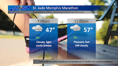
Behind the cold front on Friday evening (which will pass through with no additional rainfall), temperatures drop to the mid to upper 40s Saturday morning before rising to the lower 60s in the afternoon. Clouds will continue to stream overhead with a north wind at 5-10 mph. Overall, it should be a pretty good day for the St. Jude Memphis Marathon and other outdoor activities.


Sunday and beyond

As the late-week system finally pulls to the east, sunshine returns Sunday and continues through the first half of the week, at least. Temperatures will be a bit cooler, but not cold, with lows mostly in the 40s and highs in the upper 50s to low 60s until Wednesday when it gets a bit cooler. Overall, not much to complain about with this forecast! 

Erik Proseus
MWN Meteorologist

----
Follow MWN on Facebook and Twitter for routine updates and the latest info!
Complete MWN Forecast: MemphisWeather.net on the mobile web or via the MWN mobile app
Download our iPhone or Android apps, featuring StormWatch+ severe weather alerts!
MWN is a NOAA Weather Ready Nation Ambassador Meteorologist Erik Proseus is an NWA Digital Seal Holder

Saturday, November 18, 2023

Drought relief and possible strong storms Monday, otherwise good weather for Thanksgiving week

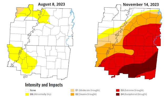
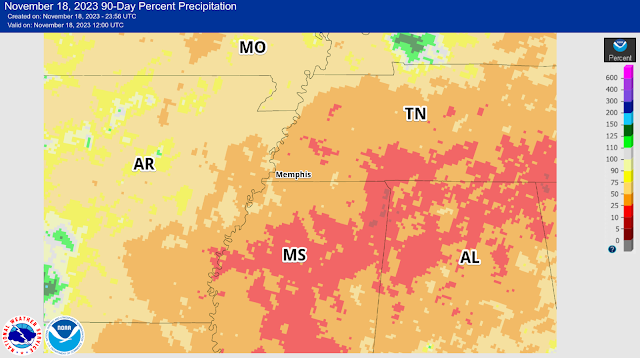
The lack of soaking rain in the past three months has resulted in quite the drought, measuring "extreme" in parts of the metro. But typically November can be counted on to bring some relief from dry fall conditions, and the next system on Monday should do just that.

A comparison of the Drought Index for the Mid-South from early August to this week tells the story about the lack of beneficial rainfall. (UNL Drought Monitor)

The rainfall deficit in the past 90 days is shown above. For the Memphis area, we only received about 25-50% of normal rainfall in this period. Conditions are worse to our south and east. (NOAA/NWS)

We'll end the weekend with similar conditions to how it started though, as Sunday looks very pleasant with plenty of sunshine, dry air, and highs in the mid 60s. A light wind shifting from the northeast to the east is a sign of what's to come though, as low pressure moves into the Plains, turning those winds around to the southeast Sunday night when a smattering of light showers are likely to start moistening the atmosphere and "priming the pump" for Monday.

By Monday, southeast wind will pick up and rain chances increase as the day goes on, particularly by mid-afternoon, as low pressure moves into AR. Highs will again be in the mid 60s, but dewpoints surge from the 30s Sunday to the 50s Monday. By late afternoon, some showers could be heavy. As of Saturday evening, it appears that low pressure system will pass by just to the north of the metro on Monday night, bringing a round of thunderstorms during the evening hours. 

The surface map for 6pm Monday shows a cold front and approaching low pressure center to our west and a warm front lifting north into the area. Locations south of that warm front could see a few strong storms Monday evening. (WPC)

To our south, where instability will be maximized, some storms could be strong to severe across southern AR into MS and eventually (later in the night) western AL. While thunder will be possible, perhaps likely, in the metro, the severe weather threat should stay just to our south, though a storm could produce strong wind gusts locally. 

The severe weather threat for Monday evening is mostly to our south, though a couple of strong storms are possible in north MS, per the Storm Prediction Center outlook posted Saturday. (SPC)

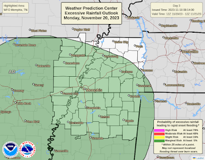
In addition, rain will be heavy, particularly from around rush hour through the evening, tapering off as a cold front moves through around midnight or so. Up to 2" of rain is possible for this event, though most places will likely remain under that, but receive at least an inch. This will certainly help with the drought, keeping it from getting any worse if nothing else.

There is a Marginal Risk of excessive rainfall that could result in flooding for the entire area on Monday. (Weather Prediction Center)

Behind this system, cooler and drier weather sets in once again for the rest of Thanksgiving week. A few lingering showers are possible Tuesday morning with temperatures that pretty much sit in the 50s all day on north wind. Skies clear for mid-week and conditions remain dry through at least Friday. Look for morning lows in the 30s to near 40, including for Thanksgiving Day, and highs generally in the mid 50s under fair skies. Sounds like a good time to take some time off work, eat too much, and maybe get the Christmas decorations out!

Erik Proseus
MWN Meteorologist

----
Follow MWN on Facebook and Twitter for routine updates and the latest info!
Complete MWN Forecast: MemphisWeather.net on the mobile web or via the MWN mobile app
Download our iPhone or Android apps, featuring StormWatch+ severe weather alerts!
MWN is a NOAA Weather Ready Nation Ambassador Meteorologist Erik Proseus is an NWA Digital Seal Holder

Saturday, November 4, 2023

October 2023 Climate Report for Memphis, TN

October Climate Recap

The month of October was generally very warm, and averaged more than a two degrees above normal. We started the month in the low 90's, dropped to the 70's by the 4th, then into the 60's by the middle of the month. A gentle warmup followed, with highs in the upper 80's by the 23rd. We finally saw much cooler temperatures on the 29th as a strong cold front moved in, with highs dropping to 49 on the 30th!

Departure from normal temperatures for October for the Lower 48 states

The ongoing drought continued in October with only just above 1.5" of rain for the month (almost 2.5" below normal). The drought was particularly bad in the counties to the south, and creeped northward into most of the Mid-South throughout the month. All of the metro is now somewhere between a moderate drought to an extreme drought. Most of the rain (1.26") occurred at the end of the month. We saw a trace amount on the 4th, 0.3" on the 5th, then only trace amounts on the 15th and 19th, followed by 0.03" on the 27th, 0.29" on the 28th, 0.42" on the 29th, and 0.52" on the 30th. In addition, the Mississippi River at Memphis set a new record low river stage at -12.04' on the 17th, 1.23 feet lower than the previous record of -10.81 set October 21st of last year.


Memphis International Airport, Memphis, TN

Temperature 
Average temperature: 67.0 degrees (2.4 degrees above average) 
Average high temperature: 77.4 degrees (2.3 degrees above average) 
Average low temperature: 56.7 degrees (2.7 degrees above average) 
Warmest temperature: 92 degrees (1st) 
Coolest temperature: 33 degrees (31st) 
Heating Degrees Days: 88 (28 below average)
Cooling Degree Days: 158 (102 above average) 
Records set or tied: Record high tied (86) and record high minimum (69) on the 24th
Comments: None

Precipitation 
Monthly total: 1.57" (2.41" below average) 
Days with measurable precipitation: 5 (2.5 days below average) 
Wettest 24-hour period: 0.94" (29th-30th) 
Snowfall: None
Records set or tied: None
Comments: None

Miscellaneous 
Peak wind: North/40 mph (6th) 
Average wind: 7.4 mph 
Average relative humidity: 61%
Average sky cover: 49%

 Click here for a daily statistical recap for Memphis International Airport.
 

MemphisWeather.net Headquarters, Bartlett, TN

Temperature 
Average temperature: 63.6 degrees 
Average high temperature: 76.1 degrees 
Average low temperature: 53.3 degrees 
Warmest temperature: 91.3 degrees (1st) 
Coolest temperature: 29.2 degrees (31st) 
Comments: High temp of 91.3 (1st) was a record for that day (since 2005); 29.2 (31st) was a record low for that day (since 2005)

Precipitation 
Monthly total: 1.56" (automated rain gauge), 1.86" (CoCoRaHS rain gauge) 
Days with measurable precipitation: 5
Wettest date: 0.55" (28th) (via automated gauge) 
Snowfall: None
Comments: None

Miscellaneous 
Peak wind: South/24 mph (26th)
Average relative humidity: 72% 
Average barometric pressure: 30.03in. Hg
Comments: None

Click here for a daily statistical recap for Bartlett, TN.
 

MWN Forecast Accuracy

MWN average temperature error: 1.98 degrees 
MWN forecast temperatures within 2 degrees of actual: 69% 
MWN average dewpoint error: 2.04 degrees 
MWN forecast dewpoints within 2 degrees of actual: 69% 

MWN's forecasts extend out five periods (2.5 days, or roughly 60 hours). Historical accuracy statistics can be found here.

----
Follow MWN on Facebook and Twitter for routine updates and the latest info!
Complete MWN Forecast: MemphisWeather.net on the mobile web or via the MWN mobile app
Download our iPhone or Android apps, featuring StormWatch+ severe weather alerts!
MWN is a NOAA Weather Ready Nation Ambassador Meteorologist Erik Proseus is an NWA Digital Seal Holder

Friday, October 27, 2023

We interrupt late summer for a taste of early winter!

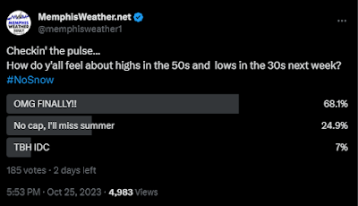
According to a recent poll we conducted on X, nearly 70% of you are ready for late summer warmth to end and "deep fall" to begin.


Well, your wish is my command! But first, let's try and get a little drought relief after suffering through less than two inches of rain since September 1. Unfortunately, rain chances are increasing over a fairly busy Halloween/fall fest weekend!

The most recent Drought Index map shows the majority of the metro in a severe (D2) drought after weeks of very little rain. (UNL)

Pre-frontal warmth and rain

A seriously cold Canadian front will ooze through the Mid-South late this weekend. However, it will be close enough the next 48 hours to bring off and on rain chances. We'll still be on the warm side of it until at least midday, or maybe evening, on Sunday so mild temperatures continue, but not quite the 80s we have had the past week. Rain will be spotty through mid to late afternoon Saturday before the next organized round of showers moves in and blankets the area Saturday evening. You'll want a Plan B for any outdoor activities starting at dinner time Saturday. Temperatures should remain mostly in the 70s after starting in the mid 60s Saturday morning. 

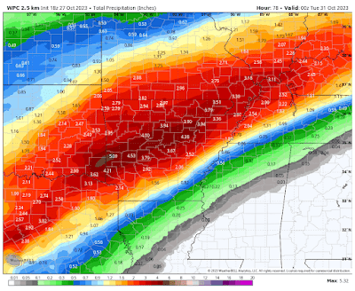
NWS forecast rainfall amounts through Monday show the potential for 1-2" across the metro with higher amounts over AR where the front stalls this weekend. (WPC/WxBell) 

Showers will continue to be scattered Sunday ahead of the front, then become increasingly likely along and behind it as we head into Sunday night. We could stay in the 60s Sunday, but at best we'll see lower 70s if there are long enough breaks in the showers.

Arrival of Canadian air

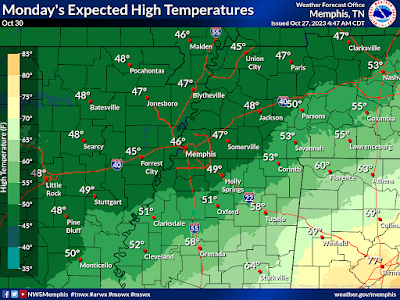
As cold air moves in Sunday night, rain continues to fall, lasting until probably mid-day Monday. And boy will it be COLD after we've been acclimated to 70s and 80s lately! (No, not cold enough for s**w though!) Monday morning we'll wake up to showers, a cold north wind, and temperatures in the mid 40s. And with rain still around and clouds not departing until late in the day, we may well not see temperatures rise at all as cold air continues to advect in on breezy north wind!

Expected high temperatures (not lows!) on Monday (NWS)

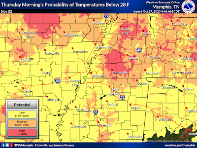
The rest of the week, starting Tuesday morning, will feel more like December or January despite abundant sunshine. Morning lows will likely drop to freezing - even in the city - while some upper 20s are possible in coldest outlying areas on Wednesday and Thursday mornings. High temperatures look to be near 50 degrees  Halloween Day and Wednesday before rebounding a bit on Thursday, then back into the low 60s by week's end. Bundle up those trick-or-treaters as wind chills will be in the 30s Tuesday evening! 

Probability of freezing temperatures Wednesday morning (NWS)

Probability of a hard freeze (28°) on Thursday morning. (NWS)

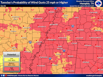
Potential for wind gusts over 25 mph is high on Halloween Day. Paired with max temperatures near 50, it will be a COLD night of trick-or treating! (NWS)

If you have outdoor winterizing that needs to be done - this weekend is the time to do it! Hose bibs should be covered, exterior doors sealed, and sensitive plants brought into the garage or indoors for a few days next week. Fortunately, the cold snap should only last a few days, as we'll be back to near normal (that's highs in the upper 60s and lows in the mid 40s) as we head into next weekend.
Erik Proseus
MWN Meteorologist

----
Follow MWN on Facebook and Twitter for routine updates and the latest info!
Complete MWN Forecast: MemphisWeather.net on the mobile web or via the MWN mobile app
Download our iPhone or Android apps, featuring StormWatch+ severe weather alerts!
MWN is a NOAA Weather Ready Nation Ambassador Meteorologist Erik Proseus is an NWA Digital Seal Holder

Wednesday, October 11, 2023

Solar eclipse "warm-up act" will occur on Saturday

While the "Great American Eclipse" will be the big story as far as solar events go in the next several months, this weekend's annular eclipse for part of the country, and partial for the rest of us, will be a very nice warm-up act! 


Occurring over a three-hour window from late morning through early afternoon on Saturday, October 14, over 60% of the sun's disk will be obscured by the moon at noon as it passes directly between the sun and Earth. 


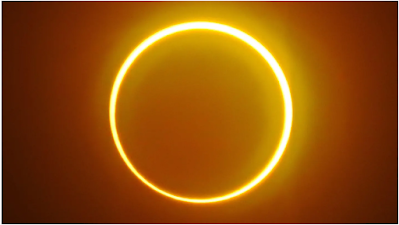
The April 2024 Great American Eclipse will be a total eclipse, in which the entirety of the sun will be obscured by the moon. However, this Saturday's eclipse will be an "annular" eclipse for those in the western United States. Annular refers to the fact that, while the moon passes directly in front of the sun like in a total eclipse, it is too small (due to its distance from our perspective) to completely block the sun, thus a "ring of fire" is visible around the outside of the moon. 

A "ring of fire" produced by an annular eclipse. Photo by Ferdinandh Cabrera/AFP via Getty Images)

For those who are outside the path of totality, a partial eclipse will be visible with a "Pac-Man shaped" sun as the moon passes in front of it. The last annular eclipse visible in the continental U.S. was in 2012, but the next one won't be until 2048! (Of course, we will have a total eclipse crossing the U.S. just 6 months from now!)


For the Memphis metro, the eclipse will start about 10:30am, peak at maximum obscuration of 61% at noon, and finish at 1:35pm. Because it is not a total eclipse, viewers absolutely should NOT look directly at the sun to observe the eclipse, unless they are wearing appropriately-rated eye protection such as rated eclipse glasses. You can also use an indirect method like a pinhole camera that can be made at home with the kids! Here is a great article covering several ways to enjoy the eclipse safely.

The forecast looks good for Saturday with a cold front arriving Friday night that should clear out by Saturday morning, leaving mostly sunny to partly cloudy skies and a northwest breeze with temps in the mid to upper 60s during the eclipse. 


More information on the annular eclipse can be found at EarthSky.orgGreatAmericanEclipse.com and NASA's Scientific Visualization Studio.

Erik Proseus
MWN Meteorologist

----
Follow MWN on Facebook and Twitter for routine updates and the latest info!
Complete MWN Forecast: MemphisWeather.net on the mobile web or via the MWN mobile app
Download our iPhone or Android apps, featuring StormWatch+ severe weather alerts!
MWN is a NOAA Weather Ready Nation Ambassador Meteorologist Erik Proseus is an NWA Digital Seal Holder

Saturday, October 7, 2023

September 2023 Climate Report for Memphis, TN

September Climate Recap

The month of September was generally very warm, and averaged more than a degree and a half above normal. But Mid-Southerners experienced a nice reprieve from the heat during the middle third of the month as "false fall" brought low dewpoints and fairly pleasant conditions following a strong front on the 7th. However, summer returned for much of the last third of the month as temperatures rose above 90 degrees once again on multiple days. No records were set despite the late season heat.


Early signs of drought that began in the Mississippi Delta spread north across the metro during the month as precipitation ended well below average during the climatologically driest month of the year. Most precipitation fell on just a few days in September, with thunderstorms occurring on the 4th, 6th, and 20th. Otherwise rainfall was spotty to non-existent. Storms resulted in Severe Thunderstorm Warnings in north MS (on the 6th) and 20th (Shelby/Tipton Counties). A tree was downed in Memphis on the 20th and a few were taken down in north MS on the 6th. In addition, the Mississippi River at Memphis preliminarily set a new record low river stage at -10.97' on the 14th, a couple inches lower than the previous record set just last year.


Memphis International Airport, Memphis, TN

Temperature 
Average temperature: 77.7 degrees (1.7 degrees above average) 
Average high temperature: 87.8 degrees (1.8 degrees above average) 
Average low temperature: 67.6 degrees (1.7 degrees above average) 
Warmest temperature: 97 degrees (4th) 
Coolest temperature: 60 degrees (18th) 
Heating Degrees Days: 0 (7 below average)
Cooling Degree Days: 388 (53 above average) 
Records set or tied: None 
Comments: 11 days reached 90°, which is 0.8 days above average for the month of September

Precipitation 
Monthly total: 1.63" (1.40" below average) 
Days with measurable precipitation: 4 (3.1 days below average) 
Wettest 24-hour period: 0.97" (6th) 
Snowfall: None
Records set or tied: Record daily rainfall tied (0.97" on the 6th)
Comments: 92% of the month's rainfall fell on just two days

Miscellaneous 
Peak wind: Northwest/39 mph (6th) 
Average wind: 6.1 mph 
Average relative humidity: 63%
Average sky cover: 41%

 Click here for a daily statistical recap for Memphis International Airport.
 

MemphisWeather.net Headquarters, Bartlett, TN

Temperature 
Average temperature: 73.5 degrees 
Average high temperature: 86.8 degrees 
Average low temperature: 63.5 degrees 
Warmest temperature: 95.8 degrees (4th) 
Coolest temperature: 53.8 degrees (15th) 
Comments: None 

Precipitation 
Monthly total: 1.32" (automated rain gauge), 1.27" (CoCoRaHS rain gauge) 
Days with measurable precipitation: 5
Wettest date: 0.53" (12th) (via automated gauge) 
Snowfall: None
Comments: None

Miscellaneous 
Peak wind: South-southwest/18 mph (5th)
Average relative humidity: 76% 
Average barometric pressure: 30.02in. Hg
Comments: None

Click here for a daily statistical recap for Bartlett, TN.
 

MWN Forecast Accuracy

MWN average temperature error: 1.83 degrees 
MWN forecast temperatures within 2 degrees of actual: 76% 
MWN average dewpoint error: 1.77 degrees 
MWN forecast dewpoints within 2 degrees of actual: 79% 

MWN's forecasts extend out five periods (2.5 days, or roughly 60 hours). Historical accuracy statistics can be found here.

----
Follow MWN on Facebook and Twitter for routine updates and the latest info!
Complete MWN Forecast: MemphisWeather.net on the mobile web or via the MWN mobile app
Download our iPhone or Android apps, featuring StormWatch+ severe weather alerts!
MWN is a NOAA Weather Ready Nation Ambassador Meteorologist Erik Proseus is an NWA Digital Seal Holder