A very wet month is about to get wetter before we turn the page to February on Tuesday. Multiple rounds of precipitation have moved through in the past couple of weeks, and looking ahead we've got another wet pattern expected for the next several days, as waves of precipitation move through. This time though, temperatures will be much more critical than recent events!
Round 1 - Saturday night/Sunday
A cold front will move into the Mid-South Sunday, stalling not far to our south by Monday morning. The first round of precip starts today and will drop 1/2" to 3/4" of rain through Sunday morning as an upper level trough precedes the cold front. Rain will be steadiest overnight tonight with a few rumbles of thunder possible in the pre-dawn hours Sunday. In addition, wind will pick up quite a bit and gusts could exceed 30 mph overnight. Temperatures should remain near 50 overnight.
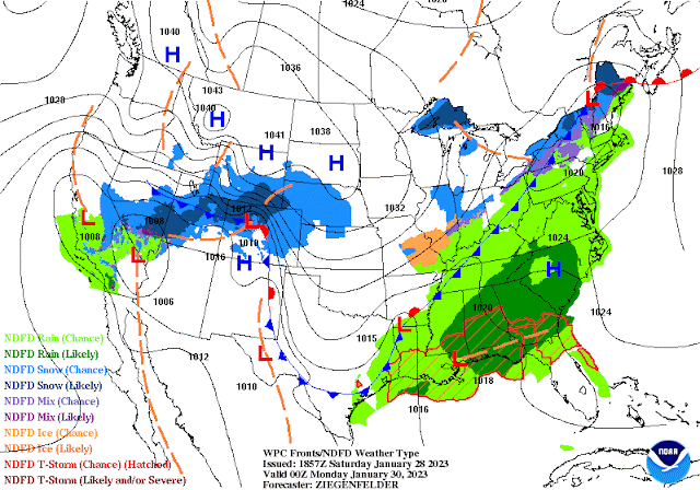 |
| As of Sunday evening, a cold front will be positioned across the metro, sinking a bit further south and ushering in cold air that will be a factor in precipitation type for a few waves of precipitation the first half of the week. (NWS/WPC) |
By mid-morning, that batch should move out and we'll be left with cloudy skies and continuing chances of showers, especially in north MS, as the wind subsides and highs top out in the upper 50s. The cold front itself moves through by early evening with another chance of scattered showers, then low clouds and drizzle overnight as temperatures fall into the upper 30s, a bit cooler north of the city. Monday will be an "in-between" day with clouds lingering and temperatures much cooler behind the front, in the mid 40s for highs.
Round 2 - Monday night/Tuesday
After Monday's lull, and with cold air in place, the next round of precipitation looks to arrive Monday night into Tuesday. This is where our medium-range models start to diverge a bit. The American models that cover that period of time bring in a pretty decent slug of moisture Monday night into early Tuesday, while the trusty European model holds back a bit, with less precipitation and not quite as early of a start Monday evening. However, all of them bring temperatures down to near or at the freezing mark by dawn Tuesday, plus or minus a couple of hours.
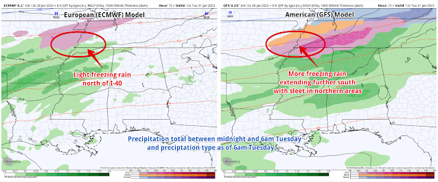 |
| A comparison of the Saturday morning European and American models for Tuesday morning. These are just two possible scenarios and do not represent all potential options. (WeatherBell) |
Because the cold air is shallow and there is warm air (above freezing) above the surface during this time (and in fact all week it appears), areas that get down to 32 degrees will receive freezing rain. The most likely place for that to happen is along and north of I-40. Northern sections of the metro (Tipton County) have a higher chance of this occurring than southern sections (north MS). The amount of precipitation that falls at 32 or below is the big question and one the models don't have a good handle on yet.
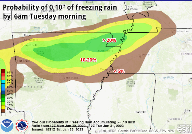 |
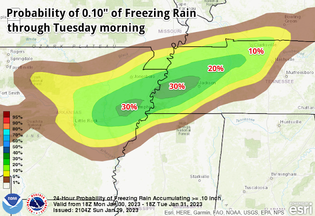
| The NWS Weather Prediction Center freezing rain probability forecast shows where the greatest chance of impactful icing is most likely on Monday night into Tuesday, specifically northern AR into northwest TN. (NWS/WPC) |
Predicting shallow cold air more than 24-48 hours out is maybe one of the biggest challenges we face and models tend to not do so well at it. One to two degrees will make all the difference. At this point, I am forecasting a chance of light freezing rain, probably less than 0.10" accumulation, for Tuesday morning roughly along and north of I-40 (or Highway 70 in west TN, if you think I-40 is overused as a geographical reference!). Higher amounts are possible well north of the metro.
Round 3 and beyond
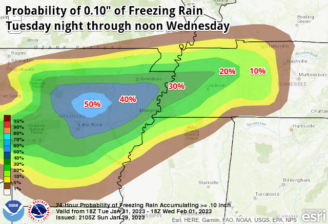
The next wave of precipitation may be the most drawn-out, though there could be some breaks the models don't see yet. It starts sometime later Tuesday and could continue through Thursday. For this time period, there are also question marks regarding the thermal profile from onset of precipitation through Wednesday morning. Since we're talking 3-4 days out, it's too early to make any definitive statements, other than to express the uncertainty involved. The European and American medium range models both agree that most areas of the greater metro, particularly south of I-40, should remain above freezing and therefore see cold rain. Just to the north, we still have some concern for northern sections of the metro, especially Tipton Co and going north from there.
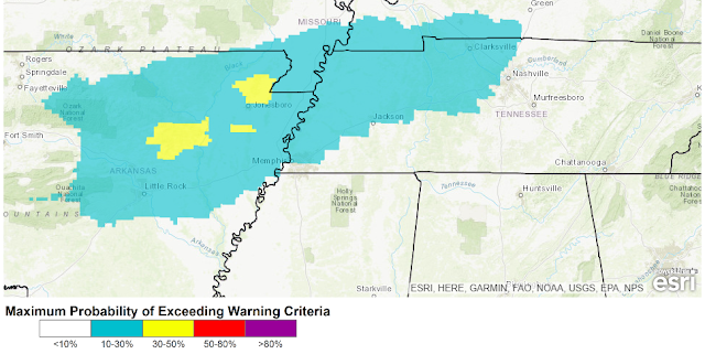 |
| The Weather Prediction Center Winter Storm Outlook depicts the probability of a Winter Storm Warning being required in the extended range, specifically for Tuesday and Tuesday night, in this graphic. Winter Storm Warning criteria is 0.25" of freezing rain. Once again, northeast AR is the most likely area where significant icing is possible, though it does not preclude lighter amounts as far south as the Memphis metro. (NWS/WPC) |
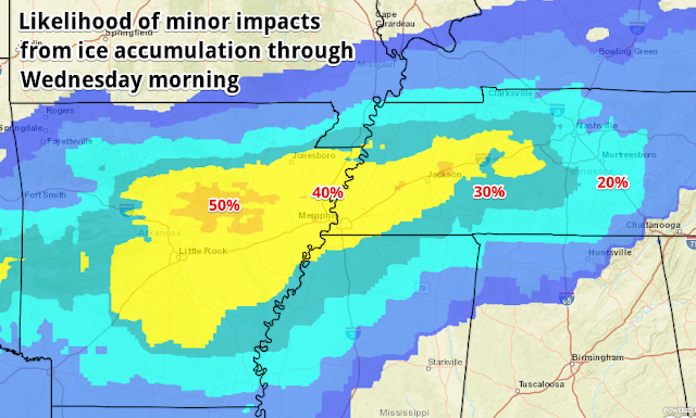
Temperatures are likely to be within a couple of degrees of freezing from Tuesday through at least mid-day Wednesday. It could be a miserable cold rain, or ice accumulation that threatens some tree limbs and power lines. Once again, the greatest concern is north of Memphis, and probably north of Shelby County, but we'll have to see what it looks like as we get closer in time. It does appear that the last 24 hours or so of precipitation (mid-day Wednesday through Thursday) should be all rain at this point, as the front lifts a bit north and warmer temps (comparatively speaking) follow. For now I am forecasting 40 degrees for a high Wednesday, mid-30s for a low Thursday morning, and low 40s Thursday afternoon. Cross your fingers!
So to recap: rain this weekend, mainly dry Monday, more rain Monday night and the potential for light icing early Tuesday, more precip starting late Tuesday with a threat of additional icing in the northern metro and points north, then rain Wednesday mid-day through Thursday. Because of warm temperatures aloft, we are NOT looking at a snow event. Colder areas in the far northern metro might see a bit of sleet at times, but freezing rain is the main concern.
We'll have more updates, especially on social media, as the forecast gets refined. The latest forecast from MWN can always be found on our mobile app or website.
Closing remarks from a team member
#TeamMWN intern Jacob Woods has had his last shift with us and will be missed a great deal. Though still a junior at Mississippi State, he has landed his first broadcast meteorology job with WVUA-TV in Tuscaloosa and starts soon. I asked him if he wanted to write a few words. Here they are:
A year full of extreme weather, learning curves, and forecast challenges has made this experience beyond humbling and necessary for my Meteorological career. I can not thank MemphisWeather.net enough for presenting this opportunity to me, allowing me to dive head first into an engaging internship that has expanded my knowledge and conceptual understanding of just how complex this atmosphere really is. Most of all, thank you for giving us younger people a chance to get our feet wet and for trusting our wording and forecasts. One like or share on social media can be a pat on the back, and for myself, this has been the most rewarding internship in my career thus far! It has been a pleasure serving the metro, but it is time to move onto my next chapter...keep it sunny Memphis!
Jacob is knowledgeable, passionate, and a great communicator and will have a phenomenal career in broadcast meteorology. We wish him all the best and thank him for his time with #TeamMWN!
Joining the team a couple of weeks ago, Dorien Minor is completing his Master's in Atmospheric Sciences at Georgia Tech and will graduate in May. Dorien hails from Maryland and is already making his mark (/DM) on our social feeds. Replacing Jacob will be Carter Bentley, a senior Professional Meteorology major at Mississippi State that also graduates in May. You'll see his social media posts (/CB) in the very near future!




.gif)

