This is an update to the blog posted on Saturday.
Recent model data, including high-resolution data that now extends out through Tuesday/Wednesday, has trended a bit cooler than previously. For those that were hoping we might miss out on icy conditions in the Memphis metro, it's not necessarily good news. For those hoping for a "snow day" (or ice day), your chances might be increasing. Now we have to hope that significant impacts will be avoided. Let's get right to it.
Monday night/Tuesday morning
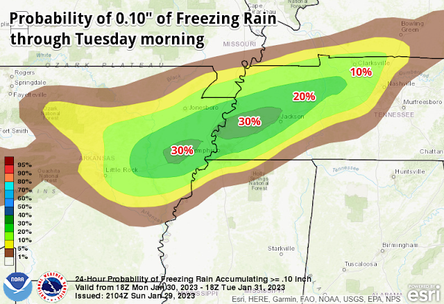
There are two time periods of concern for freezing rain in the metro. The first is Monday night/Tuesday morning. Light rain is expected to move in Monday evening with temps falling slowly in the 30s. High-res models have surface temperatures reaching freezing by about midnight with a low around 30 degrees. Precipitation from this first round should move out Tuesday morning shortly after sunrise. While precipitation should be light, it is possible that one-tenth of an inch of ice could accumulate overnight between midnight and mid-morning Tuesday.
Tuesday night/Wednesday morning
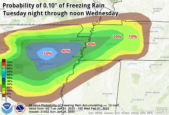
The second round of precipitation arrives sometime Tuesday afternoon or early evening. Highs Tuesday will be in the mid 30s, so it is appearing likely that by evening, we'll once again see the mercury drop to the freezing mark. While some melting of Monday night's light icing will occur in dry and "warmer" conditions Tuesday, additional accumulation appears likely Tuesday night through Wednesday morning, before temperatures once again rise above freezing. Right now, our best guess on when that happens is mid-morning Wednesday. While additional rainfall is likely Wednesday through Thursday, we expect temperatures to remain above the critical 32° point after mid-morning Wednesday. It is possible that round two could bring another 0.10-0.20" of ice.
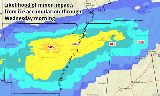
The highest potential for seeing total accumulation of one-quarter inch or more are along and north of I-40. Lighter amounts appear likely in northwest MS (DeSoto, Tunica, Marshall Counties). The city of Memphis can expect some minor icing that will likely make travel hazardous both early Tuesday morning and likely Tuesday night into Wednesday. Whether it will be enough to result in tree damage and widespread power outages is to be determined, but scattered power outages seem likely by Wednesday morning. Preparations should be made in the next 24 hours for this potential.
Also as an FYI, Winter Weather Advisories are issued by the National Weather Service when impacts to travel and commerce are expected within 24-36 hours. Winter Storm Warnings are issued when there is higher confidence in more significant impacts that may necessitate avoiding travel and preparing for more widespread power outages - which equates to at least 1/4" of ice.
Continue to monitor your local weather sources that can interpret the flood of data meteorologists are seeing over the next few days, and be aware of hyperbole or social media shares that seem "extreme." Some model data that is likely to be shared WILL be overblown and unrealistic. Rely on trusted sources that can properly filter the information. We'll keep you posted!
Erik Proseus
MWN Meteorologist
----
Follow MWN on Facebook and Twitter for routine updates and the latest info!
Complete MWN Forecast: MemphisWeather.net on the mobile web or via the MWN mobile app
Download our iPhone or Android apps, featuring StormWatch+ severe weather alerts!
 |  |
| MWN is a NOAA Weather Ready Nation Ambassador | Meteorologist Erik Proseus is an NWA Digital Seal Holder |


No comments:
Post a Comment