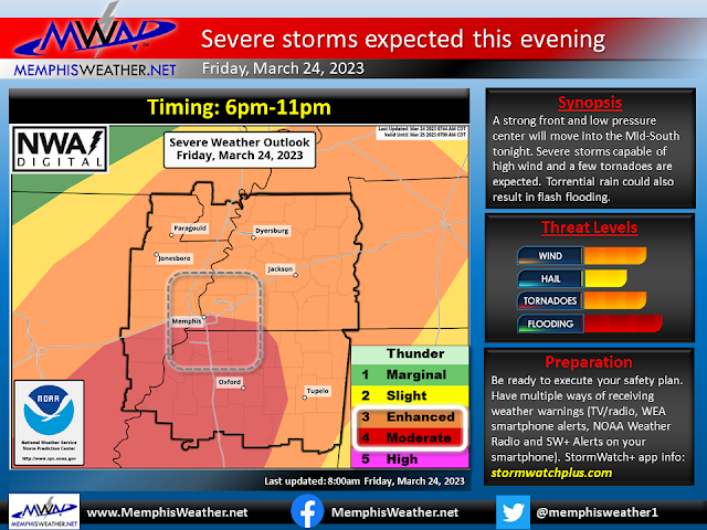
A severe weather outbreak is expected late this afternoon and evening across the Lower Mississippi Valley. The Memphis metro is on the northern edge of where the strongest storms will be possible. This blog post will go into the details, and is effective as of 11:30am Friday. Note that the severe weather outlook graphic (embedded in the slide above) will be updated a couple more times today. This blog will likely not. I don't expect a lot of change, and even if the "lines" on the outlook move a bit. The threats and your response should really not change.
Atmospheric setup
The setup for this event is a developing low pressure system that will move southwest to northeast across Arkansas this afternoon and evening, dragging a cold front with it. Very strong wind fields will result in plenty of energy for this system to tap into. Turning of those winds with height will mean there will also be plenty of wind shear to result in strengthening and maintenance of storms once they develop. Instability, particularly once you get north into west TN, will be a factor to watch. It will not be as high as areas to our south where better chances of tornadoes exist. All of these factors will be maximized during the evening hours (6pm-midnight or so). Let's look at the individual storm threats.
Damaging wind
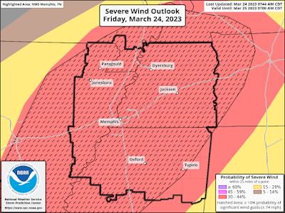
This will be our main threat tonight. There is a 30% chance of severe wind (roughly 55 mph or higher) within 25 miles of you location. There is also at least a 10% chance of 75 mph wind, shown by the black hatched area in the graphic below. We WILL get a squall line that will move through the metro. That is most likely in the 8-10pm timeframe for Memphis (earlier west, later east). High wind will be likely, some gusts could reach hurricane force.
Tornadoes
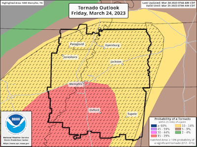
Tornadoes will be a secondary threat. There are two areas these could develop. First, in supercells that form ahead of the line (after 6pm). These are most likely in MS and northern LA, but they'll move rapidly northeast, towards southwest TN. The threat for these is higher to our south, in the MS Delta, where instability is expected to be highest. Secondly, in the squall line itself, where tornadoes could "spin-up" within the line. There is more than enough shear for this to happen, and they could also be strong, but would not likely last very long. The chance of occurrence in 10% for west TN and northeast AR and 15% in the southern metro and further south. The entire area also has a 10% chance of an EF-2 or stronger tornado due to the strong wind shear expected.
Large Hail
Large hail is the least of the the three main threats. There is about a 10% chance of occurrence for all of us. Hail would be most likely in any supercells that form (again, mainly in north MS), thus there is also a 10% risk that hail could be 2" in diameter or larger in the more unstable air south of Memphis (black hatched area below).
Flash or urban flooding
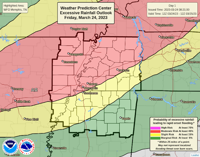
There will be a LOT of water falling in a short period of time this evening. Atmospheric moisture levels are very high. So, flash flooding is possible, small creeks and streams will rise, and low-lying areas in the concrete jungle will likely become hazardous. The NWS has placed the northern half of the Mid-South in a moderate risk (3 of 4) for excessive rainfall that could lead to flash flooding, while the southern half is in a Slight Risk (2 of 4). Rainfall amounts will easily exceed an inch in a few hours, and could approach 2-3" north of I-40. Turn around, don't drown!
Limiting factors
We've had questions about whether the morning rain that dropped south to about the state line, along with a cooling north breeze and lower dewpoints, would limit the severe potential this evening. I say "probably not."
.gif) |
| Radar loop from 9:30am Friday, showing the rain-cooled air dropping south. The warm/moist air is poised just to the south of that area where rain fell and will move back north this afternoon. |
The strong southerly wind and higher dewpoints are only a couple counties south of us. As the low forms and starts moving northeast, it will drag that warmer and more unstable air back to the north. By this evening, we'll likely be right back where we were forecast to be by the models, which leads to the setup described above. The northern areas of the metro and places north already had a slightly lower risk of severe storms, and especially supercell storms, than places to the south. That really doesn't change. So I think the current severe weather outlook from SPC (first image above) factors all of that in. It will definitely be something we watch though! If instability does not rise as expected in west TN, perhaps it will slightly limit the severe threat. Let's prepare for the worst and hope for the best though!
Prepare
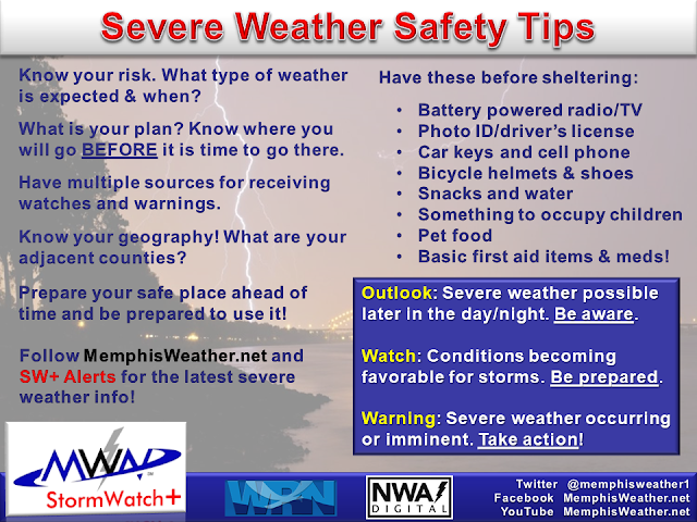
It's time to finalize your plans for this evening. Be where you know you can get to shelter if need be and be ready to act quickly. Storms will be fast-moving. Expect a line of storms with high wind between about 8-10pm. Make sure stuff outside is tied down. Know the counties around you and stay weather aware so you know when it is getting close. Finally, have multiple ways to get warning information, as any one could fail in severe weather. We recommend a NOAA Weather Radio, local TV outlets, Wireless Emergency Alerts on your smartphone, and a more customizable app option, such as our StormWatch+ app for Android and iOS. Of course, keep those devices charged today! Power outages are expected tonight.
Erik Proseus
MWN Meteorologist
----
Follow MWN on Facebook and Twitter for routine updates and the latest info!
Complete MWN Forecast: MemphisWeather.net on the mobile web or via the MWN mobile app
Download our iPhone or Android apps, featuring StormWatch+ severe weather alerts!
 |  |
| MWN is a NOAA Weather Ready Nation Ambassador | Meteorologist Erik Proseus is an NWA Digital Seal Holder |


No comments:
Post a Comment