Pages

Thursday, April 13, 2023

Beautiful spring weather may be interrupted by severe weather on Saturday

A cloudy and cool Easter weekend gave way into a pleasant early week for the Memphis Metro. As the weekend approaches, we prepare for our next round of rain and the possibility of severe weather that could disrupt some Saturday evening plans.

Thursday

A low pressure system is currently sitting over southern Mississippi, this will bring clouds and some passing showers in the afternoon to evening hours. Due to the positioning of the low pressure to our south, rain will be moving to the west, rather than its usual eastward motion, as it rotates counter-clockwise around the low. Despite the clouds and rain, temperatures reached the mid 70s for highs and will drop into the upper 50s overnight.

Visible satellite from Thursday afternoon shows the center of the low-pressure over southern Mississippi with western moving clouds over Memphis. (College of DuPage)

Friday

Clouds will begin to be more broken throughout the day on Friday as the low pressure to the south begins to weaken and moves off to the northeast. Temperatures will be warmer ahead of the next system with highs in the mid 70s and lows in the lower 60s.

Saturday

The Storm Prediction Center has placed the Memphis Metro in a Slight Risk (level 2 of 5) for severe storms on Saturday.

A level 2 out of 5 severe weather risk has been issued for Saturday. (SPC)

Highs temperatures nearing 80 and dewpoints climbing into the mid 60s will provide the fuel for this system, and a cold front moving across the great plains towards the east coast be the spark for these storms to start to form. Some prefrontal showers are possible in the morning. Due to the time difference between these storms and a line expected to move through, they will not have much of a limiting impact on the later storms. 

Isolated storms are possible in western Arkansas when they are first forming in the afternoon, but they quickly become linear over central Arkansas by late afternoon. As the storms approach the metro, they will lose daytime heating and some intensity. Once the line nears the river around midnight it should begin to break up, meaning that our Arkansas counties have a slightly higher chance of seeing some severe storms, but strong to severe storms are possible across the whole metro. The primary threats with this system will be strong winds, large hail, and locally heavy rainfall.

The high-resolution NAM model shows what the radar could look like from 5am Saturday to 1am Sunday. The line should begin to break up as it nears the river. (WeatherBell)

Sunday-Thursday

The front will be followed by clear skies and highs in the mid 60s. Skies will remain clear as temperatures build back into the 80s early next week before the next chance of rain near the end of next week

Carter Bentley
MWN Intern

----
Follow MWN on Facebook and Twitter for routine updates and the latest info!
Complete MWN Forecast: MemphisWeather.net on the mobile web or via the MWN mobile app
Download our iPhone or Android apps, featuring StormWatch+ severe weather alerts!
MWN is a NOAA Weather Ready Nation Ambassador Meteorologist Erik Proseus is an NWA Digital Seal Holder

Saturday, April 8, 2023

March 2023 Climate Report for Memphis, TN

March Climate Recap

Temperatures for the month of March in Memphis averaged 0.9 degrees above normal, though that departure was driven exclusively by overnight lows averaging more than two degrees above normal due to extensive cloud cover and precipitation. Those same conditions actually resulted in daytime high temperatures averaging below normal for the month.  March started out with highs in the 70's, followed by a cold front on the 8th that pushed highs into the 50's & even upper 40's by the 13th.  After a brief warm-up, another reinforcing front resulted in highs in the 40's and 50's from the 18th to 22nd and lows dropping into the mid 20's on the 19th and 20th, freezing many early blooming plants. Highs rose back above normal to the 60's to 70's for the remainder of the month, with lows in the 40's and 50's.


March's precipitation was almost three inches above normal and totaled nearly nine inches for the month. Overall, rain fell on almost half of the days during the month with a few rounds of severe weather mixed in as well. Over three inches of rain was recorded from the 1st to the 3rd.  Additional rain fell from the 8th thru the 12th, 16th-17th, 21st-22nd, and 1.6 inches fell on the 24th.  Light amounts fell from the 27th through the end of the month. Thunderstorms occurred on the 1st-3rd, 12th, 24th and 31st. Sporadic wind damage and flash flooding were reported across the metro on the morning of the 3rd and the evening of the 24th. Hail was also reported in northern Marshall County on the evening of the 1st. 

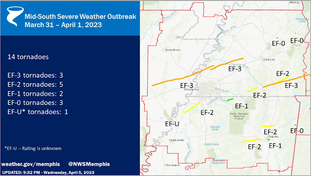
To end the month, a severe weather outbreak, producing multiple strong tornadoes from a small handful of supercell thunderstorms, affected the Memphis region on the evening of March 31. A total of 14 tornadoes touched down in the Memphis County Warning Area (CWA), which encompasses west TN, northeast AR, the Missouri bootheel, and north Mississippi. Three of these tornadoes were rated EF-3 and another five were EF-2. The graphic below summarizes their tracks.  More information from the NWS can be found here & in our recent blog post here.

Tornado tracks from March 31-April 1 in the NWS-Memphis county warning area


All NWS warnings issued and subsequent storm reports received for March 31-April 1


Memphis International Airport, Memphis, TN

Temperature 
Average temperature: 55.1 degrees (0.9 degrees above average) 
Average high temperature: 63.7 degrees (0.5 degree below average) 
Average low temperature: 46.4 degrees (2.1 degrees above average) 
Warmest temperature: 79 degrees (23rd & 26th) 
Coolest temperature: 25 degrees (19th & 20th) 
Heating Degrees Days: 318 (34 below average)
Cooling Degree Days: 20 (2 above average) 
Records set or tied: None
Comments: Five days dropped to freezing or below. A cold snap mid-month, with lows of 25 degrees on both the 19th and 20th, was damaging to early growth on plants. However, the last spring freeze of the season occurred on the 20th, only two days later than average.

Precipitation 
Monthly total: 8.67" (2.93" above average) 
Days with measurable precipitation: 14 (3.5 days above average) 
Wettest 24-hour period: 2.04" (1st-2nd) 
Snowfall: None
Records set or tied: None
Comments: None

Miscellaneous 
Peak wind: West/38 mph (24th) 
Average wind: 9.5 mph 
Average relative humidity: 66%
Average sky cover: 56%

 Click here for a daily statistical recap for Memphis International Airport.
 

Cirrus Weather Solutions / MemphisWeather.net, Bartlett, TN

Temperature 
Average temperature: 54.0 degrees 
Average high temperature: 64.6 degrees 
Average low temperature: 44.2 degrees 
Warmest temperature: 83.5 degrees (26th) 
Coolest temperature: 26.1 degrees (14th) 
Comments: None 

Precipitation 
Monthly total: 8.25" (automated rain gauge), 7.75" (manual CoCoRaHS rain gauge) 
Days with measurable precipitation: 15
Wettest date: 1.63" (24th) (via automated gauge) 
Snowfall: None
Comments: None

Miscellaneous 
Peak wind: 33 mph (occurred twice - from the northwest on the 24th and south on the 31st)
Average relative humidity: 69% 
Average barometric pressure: 30.05 in. Hg
Comments: None

Click here for a daily statistical recap for Bartlett, TN.
 

MWN Forecast Accuracy

MWN average temperature error: 2.13 degrees 
MWN forecast temperatures within 2 degrees of actual: 67% 
MWN average dewpoint error: 2.13 degrees 
MWN forecast dewpoints within 2 degrees of actual: 64% 

MWN's forecasts extend out five periods (2.5 days, or roughly 60 hours). Historical accuracy statistics can be found here.

----
Follow MWN on Facebook and Twitter for routine updates and the latest info!
Complete MWN Forecast: MemphisWeather.net on the mobile web or via the MWN mobile app
Download our iPhone or Android apps, featuring StormWatch+ severe weather alerts!
MWN is a NOAA Weather Ready Nation Ambassador Meteorologist Erik Proseus is an NWA Digital Seal Holder

Thursday, April 6, 2023

Recap of the March 31, 2023 tornado outbreak in the Memphis area

A severe weather outbreak, producing multiple strong tornadoes from a small handful of supercell thunderstorms, affected the Memphis region on the evening of March 31-April 1. A total of 14 tornadoes touched down in the Memphis County Warning Area (CWA), which encompasses west TN, northeast AR, the Missouri bootheel, and north Mississippi. Three of these tornadoes were rated EF-3 and another five were EF-2. The graphic below summarizes their tracks.


Within the eight-county Memphis metropolitan area covered by MemphisWeather.net (MWN), there were four tornado paths. Detail on each of these is summarized below. More detailed information from NWS-Memphis on all 14 tornadoes can be found here.  


Cross/Crittenden/Tipton County Tornado

Rating:                 EF-3
Est. Peak Wind:   150 mph
Path Length:        73.00 miles
Path Width (max):   1600 yards (0.91 miles)
Fatalities:             4
Injuries:               26
Start Time:           4:30pm
End Time:            5:54pm
Approx. Speed:    52 mph


Summary:
The "Wynne Tornado" touched down in western Cross County, AR at 4:30pm, spawned by the same supercell thunderstorm that resulted in tornado damage in North Little Rock earlier. The storm moved quickly east-northeast across Wynne with EF-3 strength, ravaging Wynne High School and destroying multiple residences. Slightly weaker, it passed north of Earle, AR (Crittenden Co) and crossed farmland before regaining EF-3 strength as it crossed Corna Lake in far western Tipton Co (west of the Mississippi River) before crossing the river and producing EF-2 damage in Wilder Farms (Tipton Co), eventually lifting near Burlison.


Tipton/Haywood County Tornado

Rating:                 EF-3
Est. Peak Wind:   150 mph
Path Length:        39.53 miles
Path Width (max):   2000 yards (1.14 miles)
Fatalities:             1
Injuries:               28
Start Time:           5:48pm
End Time:            6:29pm
Approx. Speed:   58 mph


Summary:
The "Covington Tornado" originated from the same supercell thunderstorm as the Wynne tornado, and touched down six minutes before the Wynne tornado lifted, meaning the supercell produced twin tornadoes for that six-minute period over Tipton Co. This tornado touched down at 5:48pm just northwest of Munford and moved quickly northeast while increasing in strength as it approached Highway 51 south of Covington. Several homes and businesses were completely destroyed and many more were significantly damaged. Fifty-three power poles had to be replaced along Highway 51 south of Covington. The elementary and middle schools sustained heavy damage, as did additional homes along Highway 54. A couple of large metal power poles were bent to the ground as the tornado widened to a mile in width as it moved across rural area east of Covington. It continued east-northeast across farmland and Hatchie River wetland before weakening and eventually lifting north of Brownsville in Haywood Co. 


Tunica/DeSoto County Tornado

Rating:                 EF-2
Est. Peak Wind:   130 mph
Path Length:        22.87 miles
Path Width (max):   1200 yards (0.68 miles)
Fatalities:             0
Injuries:               0
Start Time:           7:31pm
End Time:            8:02pm
Approx. Speed:   47 mph


Summary:
The "Prichard-Nesbit Tornado" touched down just northeast of the Tunica airport, moving northeast, mainly through rural areas of Tunica and DeSoto Co. Snapped and uprooted trees were observed in Tunica and southwest Desoto county.  Roof damage occurred after passing thru the Arkabutla bottom, with extensive tree damage and damaged or destroyed homes noted west of Highway 301.  Between Baldwin & Fogg Rd there was EF-2 damage and the tornado dissipated southwest of Nesbit.


Marshall County Tornado

Rating:                 EF-1
Est. Peak Wind:   95 mph
Path Length:        8.13 miles
Path Width (max):  100 yards
Fatalities:             0
Injuries:               0
Start Time:           8:27 pm
End Time:            8:37 pm
Approx. Speed:   50 mph


Summary:
An EF-1 tornado touched down in Marshall county west of Highway 311, moving northeast before dissipating about ten minutes later northeast of Slayden. Primary damage was to hardwood trees that were snapped or uprooted, while one home also sustained roof damage.

Shelby County Damaging Wind

Finally, MWN surveyed the Sea Isle area of southeast Memphis, near I-240 and Mt. Moriah Road leading into the area of Quince and Estate, as well as American Way between Getwell and Mt. Moriah Roads. Over this large area, many mature hardwood trees were uprooted or had large branches snapped by strong wind. Trees were observed to have fallen on houses, vehicles, and power lines/poles, resulting in additional damage and thousands of customers without power. Near American Way and Getwell, a high-voltage transmission tower was bent over (though a photo of the tower prior to the storm suggested that it may have had preexisting damage that had weakened the structure). In addition, there were three fatalities, including two children, due to a tree falling on their home on South Edgewater Road in the area of Memphis International Airport.

Given the scattered nature of the damage and no "ground path" observed, the damage was due to straight-line wind on the edge of a strong supercell that moved by just to the east of this area into Germantown. The National Weather Service and NEXRAD radar corroborates that this damage was caused by up to 85 mph wind generated by the "forward flank downdraft" of the supercell.

Erik Proseus
MWN Meteorologist

----
Follow MWN on Facebook and Twitter for routine updates and the latest info!
Complete MWN Forecast: MemphisWeather.net on the mobile web or via the MWN mobile app
Download our iPhone or Android apps, featuring StormWatch+ severe weather alerts!
MWN is a NOAA Weather Ready Nation Ambassador Meteorologist Erik Proseus is an NWA Digital Seal Holder

Tuesday, April 4, 2023

A windy and stormy Wednesday ahead - details on potential threats

After severe storms have battered the Southeast for the past two weeks, we unfortunately have another severe risk this week. Today, we will warm up into the mid-80s with mostly cloudy skies as the warm sector takes over. The severe threat today clips the metro, but will stay to the northwest mostly, with our threat moving in tomorrow. After last Friday's severe weather, any preparations need to be made ahead of time, especially for areas impacted by the last storm system. The worst of this system appears to be well north of the Mid-South, but we are still in a heightened severe weather risk zone.

Overview

A strong storm system is going to be moving across the country, causing severe weather to impact millions from the Great Lakes to the Gulf Coast. Most of the northern metro is under an Enhanced Risk (Level 3/5) Wednesday with the southern half mostly in a Slight Risk (Level 2/5). This can still change as we get closer to the event. This means that severe weather is possible to likely in the area, but that does not necessarily mean your exact town will see severe weather. The timeframe for our biggest concern is looking to be early afternoon into the evening, with more specific timing as we get closer to the event. Some pop-up showers and storms are possible ahead of the main threat too, which could play a factor into the instability, or the storm fuel that is required to produce severe weather.


Tornado Threat

The Enhanced and Slight risks can be broken down into threat by severe weather type, including tornadoes, damaging winds, and hail. Starting with the tornado threat, compared to the last few events the threat for tornadoes is lower than last week, but still present. Our area lies between the 2% and 5% risk for tornadoes, meaning that the threat for tornadoes is low, but one could still spin up with any storms that become severe. Any showers and storms during the day before the main threat could keep instability in check, which could help limit the threat.

Tornado risk for Wednesday (NOAA/SPC)

Damaging Wind Threat

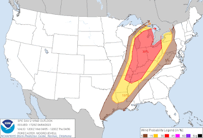
While the tornado threat is in the lower side, this is looking to be more of a damaging wind threat for our area. Outside of storms, we could see gusts above 30 mph during the day with higher winds aloft. The metro lies mostly in the 30% risk area, which is the chance of seeing 60+ mph winds within a 25 mile radius of a location. The southern half of the metro lies within a 15% risk area. Any storm that becomes severe will be capable of damaging winds as broken storms move arrive during the afternoon and more of a squall line in the early evening hours. Power outages and wind damage will be possible so make sure any loose objects are to up and secure.

Damaging wind risk for Wednesday (NOAA/SPC)

Hail Threat

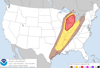
Most storms that become severe do have hail potential, and so we do have a hail risk for tomorrow's event. Our hail threat is not as high as northern states impacted by this same event, but we do have a 15% chance of hail within 25 miles of a location. Along with a hail threat, we also have a threat for minor flooding during the afternoon and evening as 1-3” of rain is possible. Avoid low-lying areas and roadways and do not drive through flooded areas.

Hail risk for Wednesday (NOAA/SPC)

Summary

Timing: early afternoon into the mid-evening
Overall threat: Enhanced (level 3/5) (west TN, northeast AR) to Slight (level 2/5) (north MS)
Tornado risk: 2-5% within 25 miles
Wind risk: 30% within 25 miles
Hail risk: 15% within 25 miles

Preparation

Use today and Wednesday morning to prepare for potential severe weather. That includes being ready to use your safe place if necessary, having outdoor items secured, and having multiple ways of receiving weather warnings, including LOCAL TV/radio, NOAA Weather Radio, Wireless Emergency Alerts on your phone, and a reliable weather warning app, such as StormWatch+ that is programmed ahead of time.

Kailah Gordon
MWN Intern

----
Follow MWN on Facebook and Twitter for routine updates and the latest info!
Complete MWN Forecast: MemphisWeather.net on the mobile web or via the MWN mobile app
Download our iPhone or Android apps, featuring StormWatch+ severe weather alerts!
MWN is a NOAA Weather Ready Nation Ambassador Meteorologist Erik Proseus is an NWA Digital Seal Holder