After severe storms have battered the Southeast for the past two weeks, we unfortunately have another severe risk this week. Today, we will warm up into the mid-80s with mostly cloudy skies as the warm sector takes over. The severe threat today clips the metro, but will stay to the northwest mostly, with our threat moving in tomorrow. After last Friday's severe weather, any preparations need to be made ahead of time, especially for areas impacted by the last storm system. The worst of this system appears to be well north of the Mid-South, but we are still in a heightened severe weather risk zone.
Overview
A strong storm system is going to be moving across the country, causing severe weather to impact millions from the Great Lakes to the Gulf Coast. Most of the northern metro is under an Enhanced Risk (Level 3/5) Wednesday with the southern half mostly in a Slight Risk (Level 2/5). This can still change as we get closer to the event. This means that severe weather is possible to likely in the area, but that does not necessarily mean your exact town will see severe weather. The timeframe for our biggest concern is looking to be early afternoon into the evening, with more specific timing as we get closer to the event. Some pop-up showers and storms are possible ahead of the main threat too, which could play a factor into the instability, or the storm fuel that is required to produce severe weather.
Tornado Threat
The Enhanced and Slight risks can be broken down into threat by severe weather type, including tornadoes, damaging winds, and hail. Starting with the tornado threat, compared to the last few events the threat for tornadoes is lower than last week, but still present. Our area lies between the 2% and 5% risk for tornadoes, meaning that the threat for tornadoes is low, but one could still spin up with any storms that become severe. Any showers and storms during the day before the main threat could keep instability in check, which could help limit the threat.
 |
| Tornado risk for Wednesday (NOAA/SPC) |
Damaging Wind Threat
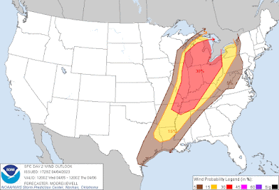
While the tornado threat is in the lower side, this is looking to be more of a damaging wind threat for our area. Outside of storms, we could see gusts above 30 mph during the day with higher winds aloft. The metro lies mostly in the 30% risk area, which is the chance of seeing 60+ mph winds within a 25 mile radius of a location. The southern half of the metro lies within a 15% risk area. Any storm that becomes severe will be capable of damaging winds as broken storms move arrive during the afternoon and more of a squall line in the early evening hours. Power outages and wind damage will be possible so make sure any loose objects are to up and secure.
 |
| Damaging wind risk for Wednesday (NOAA/SPC) |
Hail Threat
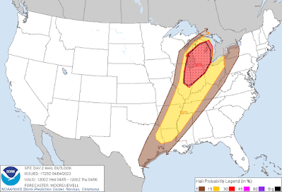
Most storms that become severe do have hail potential, and so we do have a hail risk for tomorrow's event. Our hail threat is not as high as northern states impacted by this same event, but we do have a 15% chance of hail within 25 miles of a location. Along with a hail threat, we also have a threat for minor flooding during the afternoon and evening as 1-3” of rain is possible. Avoid low-lying areas and roadways and do not drive through flooded areas.
 |
| Hail risk for Wednesday (NOAA/SPC) |
Summary
Timing: early afternoon into the mid-evening
Overall threat: Enhanced (level 3/5) (west TN, northeast AR) to Slight (level 2/5) (north MS)
Tornado risk: 2-5% within 25 miles
Wind risk: 30% within 25 miles
Hail risk: 15% within 25 miles
Preparation
Use today and Wednesday morning to prepare for potential severe weather. That includes being ready to use your safe place if necessary, having outdoor items secured, and having multiple ways of receiving weather warnings, including LOCAL TV/radio, NOAA Weather Radio, Wireless Emergency Alerts on your phone, and a reliable weather warning app, such as StormWatch+ that is programmed ahead of time.
MWN Intern
----
Follow MWN on Facebook and Twitter for routine updates and the latest info!
Complete MWN Forecast: MemphisWeather.net on the mobile web or via the MWN mobile app
Download our iPhone or Android apps, featuring StormWatch+ severe weather alerts!
 |  |
| MWN is a NOAA Weather Ready Nation Ambassador | Meteorologist Erik Proseus is an NWA Digital Seal Holder |


No comments:
Post a Comment